The Sinking Of The Norwester

The friendliest place on the web for anyone who enjoys boating.
If you have answers, please help by responding to the unanswered posts.
Where were the high capacity pumps with which the USCG could have used in an attempt to keep her afloat while towing to a yard? It just looks like everybody is standing around with their thumbs hitched in their belts in exceptionally benign water conditions. Also makes me wonder whether there was anybody aboard with the knowledge oh how to attempt slowing the water ingress.


After reading all the threads and see the GoFundMe posting, I’d say this is mighty suspicious. It would be interesting to see if there was anything of high value onboard or if any of that had been previously removed.
 
It is not the insurance carriers job to make arrangements for salvage, pollution cleanup, etc...

That is YOUR job as a boat owner. YOU are liable for the results of your boat accident.

The insurance companies job is to write the checks based on your policy language.

+1 Thanks Kevin.
 
Offering a few pointers for new boaters to consider has they read through this tragic account. This seems like a situation where everybody loses and there are no winners. Some of my points may help some of the folks with less sea time under their belts.
1. Just because you have the latest a greatest electronic device to display chart data doesn't mean the chart data is the latest and greatest.
2. Charts are not perfect, every rock or part of a reef may not be charted. If a group of rocks is shown expect other uncharted rocks close by like 25-100feet.
3. Charts in some developing countries may be based on soundings from ages ago and the will not match GPS coordinates. The general shape of an island may be correct but it may be 1/4 mile off from it's actual location. Yes an island may be a 1/4 or more off from where it's suppose to be.
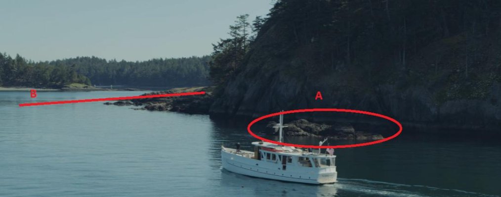
4. You need to pay attention to your surroundings and think. In the picture attached note rock A, if you see something like that anywhere on the west coast of the U.S., Canada or Alaska consider that there may be a similar rock below the surface close by. In the picture look at the red line B. If a shoreline that gradually slopes into the water expect the underwater contour to be similar. These are not absolute statements but general guidelines that can help keep you out of trouble. Do you really want to be running at speed going by rock A and do you want to cross line B? Even if the chart shows that it's clear use the clues that mother nature gives you to evaluate the situation. If you have a choice stay away from rock A and don't cross line B. Also consider the event of a mechanical failure close to a rock or reef that could do you harm. It's my opinion the Norwester was running close to shore to create compelling marketing material. Running close to a rocky shore is not a best practice, again I am guessing they were running the shoreline for a specific purpose. Think about if you lose your steering how many minutes or seconds you may have before you smack a rock. If you have the ability to give yourself some space from danger do it.
5. If you have to go through an area that you are unsure of go check it out with a dinghy first and get soundings. No depth sounder in the dinghy, no problem use a thin rope and weight(lead fishing weight, wrench, rock in a bag) After you confirm a viable path then bring the big boat through.
6. If you have no dinghy, kayak or other vessel to scout with go dead slow like 1 or 2 knots. Click the in and out of gear, if you're going to clip a rock with your prop it's better to do it in neutral than in gear. There is usually a big difference in hitting something at 1 knot vs 5, 10 or 20 knots.

Stay safe gang.
 

Attachments

  • Rock.jpg
    Rock.jpg
    40.8 KB · Views: 55
6. If you have no dinghy, kayak or other vessel to scout with go dead slow like 1 or 2 knots. Click the in and out of gear, if you're going to clip a rock with your prop it's better to do it in neutral than in gear. There is usually a big difference in hitting something at 1 knot vs 5, 10 or 20 knots.


And if doing this and you're getting close to minimum comfortable depth, put someone on the bow, especially if the water is clear-ish. They may not be able to accurately judge depth, but you at least have a shot at knowing about and avoiding anything that's sticking up from the bottom.
 
OMG - Image from RedRascal on post 93 tells just how dumb the captain was... or how clever... depending on "things"; that may or may never come to light.

Video [clstevens - post #32] showing how totally damaged the entire keel and bottom was stem to stern shows either fairly high speed collision or a very poorly maintained bottom [rot, old fasteners maybe] or a combination of both??

This whole situation is sad and leaves a lot of questions!
 
Last edited:
One article reported that the Coast Guard requested they drop their anchor so the boat didn't float away. And in the first video posted here you could see the anchor chain was out.


Why do you suppose the anchor was retrieved or released, allowing the boat to float away? Maybe it was taken as part of stripping the boat?
 
It looked to me from the diver video that the anchor was dropped straight down with no scope at all. If it was still deployed its unlikely it did much good, but the diver mentioned they had put a stern anchor down as well so was that also not correctly deployed? Hard to believe they didn't set the stern anchor but I suppose anything is possible.
Something doesn't make sense with the whole anchoring situation.
 
2. Charts are not perfect, every rock or part of a reef may not be charted. If a group of rocks is shown expect other uncharted rocks close by like 25-100feet.

Plotters are not perfect either. Assuming operator had WAAS and WGS84 selected, and assuming external antenna, gps is only accurate to 3-4 meters. And that is highly dependent upon satellite configuration.

Surveying equipment may be accurate to 1", but your $300 Garmin is not.
 
This article has a drone video following the vessel before the strike and after. That drone would have video of the strike as it occurred.
https://www.einnews.com/pr_news/539513257/john-wayne-s-first-yacht-sinking-in-the-san-juan-islands

The picture I posted in post #93 came from about the 39 second mark in the above video. Probably about 10-15 seconds more would have been the point of grounding.

The reef is discussed in the $35 Waggoner Cruising Guide which I believe is one of the popular guides for the area. It clearly talks about the reef going dry and not cutting the corner. Cruising guides can be great way to supplement charts. If someone writes about a rock or hazard I believe them over what I see on a chart.
 
One article reported that the Coast Guard requested they drop their anchor so the boat didn't float away. And in the first video posted here you could see the anchor chain was out.

Why do you suppose the anchor was retrieved or released, allowing the boat to float away? Maybe it was taken as part of stripping the boat?

I could see it being a communication issue, salvage crew was told to stripe the boat so they did. Who knows if they were told to secure the hull or leave it unsecure.

At this point I wish somebody would sink it or pull it out before it causes trouble.
 
The picture I posted in post #93 came from about the 39 second mark in the above video. Probably about 10-15 seconds more would have been the point of grounding.

The reef is discussed in the $35 Waggoner Cruising Guide which I believe is one of the popular guides for the area. It clearly talks about the reef going dry and not cutting the corner. Cruising guides can be great way to supplement charts. If someone writes about a rock or hazard I believe them over what I see on a chart.
yes saw your post 93. At that moment they were heading away from point of impact. IMO, it looked that way.
I am sure there is video from the drone showing the collision and beyond. As I understand these drones can be programmed to follow. No way that drone landed on the ship seconds before the strike and then took off again. 4 of 5 on board ended in the water. The missing minutes may be interesting footage.
 

Latest posts

Back
Top Bottom