Lopez Island Grounding

The friendliest place on the web for anyone who enjoys boating.
If you have answers, please help by responding to the unanswered posts.
I saw the boat on the hard in La Conner yesterday. It looked like a crack on the keel at the bow had been patched with something like MarineTex. There were also some nasty dents on either side, maybe 6 or 8 inches wide and an inch or two deep. It must have hit pretty hard to dent it like that.

That’s really interesting that they wound up in La Conner. Thanks for the report, ScottRhodes!
 
I hope that wasn't a relocation by the vendor's relocation crew.
Why do you say that? Are you thinking liability? Future employment?

Absolutely. The speculation was that frequently, a boat named with the model is a 'display/show'. Nobody wants to go aground, but it happens. It sucks when it happens to a recreational mariner, but ramifications could be potentially far worse when it happens with a professional mariner.
 
I saw the boat on the hard in La Conner yesterday. It looked like a crack on the keel at the bow had been patched with something like MarineTex. There were also some nasty dents on either side, maybe 6 or 8 inches wide and an inch or two deep. It must have hit pretty hard to dent it like that.

probably patched with splash zone. that stuff is almost magic. i keep a supply of it on board all the time. you can apply a patch under water and it'll cure. hull breaches, emergency fuel or water tank repairs, whatever.
 
Not knowing any details of this incident —-


With more and more use of plug and play navigation accidents can arise. Dead reckoning, range markers, physical buoy locations and paper charts remain a viable first choice in many cases.
Lol physical bouys are starting to disappear and replaced with electronic (AIS) bouys!
 
Lol physical bouys are starting to disappear and replaced with electronic (AIS) bouys!

Can you clarify? An AIS equipped buoy would still need to float. In additional, it would need to have a power source and the ability to broadcast an AIS signal.

I also could find no reference to the USCG removing ATONS.
 
Thread Drift - AIS Aids to Navigation

Please move to new thread if deemed appropriate.

Overview (2014) of AIS aids to navigation including terms:

https://gcaptain.com/uscg-ais-aton-navigation/

A more comprehensive overview:

https://www.nauticalcharts.noaa.gov/publications/portrayal-of-ais-aids-to-navigation.html

Three types of AIS ATON:

There are thousands of buoys and beacons in U.S. waters. A growing number of these are AIS ATONs, of which there are three types. The Coast Guard calls these “real” (or “physical”), “synthetic,” and “virtual.”

Real AIS ATON - A physical aid to navigation structure on which an AIS transmitter is affixed and from which AIS messages are broadcast.

Synthetic AIS ATON - A physical aid to navigation structure, without an AIS transmitter, but for which AIS messages are broadcast from another (usually land-based) location.

Virtual AIS ATON - An aid to navigation with no physical structure. It exists only through AIS messages broadcast from another location. A few uses of virtual ATONs include environments where buoys are moved seasonally, such as in sea ice, or where a marker needs to be placed quickly, such as to mark a newly identified isolated danger or wreck. These aids can only be seen on an Electronic Chart Display and Information System (ECDIS), or other AIS enabled display, such as a ship’s radar.
 
Last edited:
Thank You Jeff.

An example would be the west entrance to Juan De Fuca, Cape Flattery is a rock. It used to have a physical red can. It no longer there. It has been removed and an AIS ATON has replaced it.
 
And that’s why I use a chartplotter for every move.
 
Thank You Jeff.

An example would be the west entrance to Juan De Fuca, Cape Flattery is a rock. It used to have a physical red can. It no longer there. It has been removed and an AIS ATON has replaced it.


And most of, if not all of the puget sound VTS turn buoys or virtual now.
 
Earlier today, I put ARCTUROS into marinetraffic.com and looked at the her past track and speed. I plotted the location of a speed reduction to Navionics and the position is marked by the “crosshairs” on the attached screen shot.

Not any conclusion, but the information indicates to me that the incident did not occur in the entrance channel. Indeed the entrance-proper has soured many weekends…we have seen it ourselves.

To be clear, I am NOT slinging mud here…only pointing out the probable location for safety and awareness of ourselves and others.

Agreed, the track recorded by Marinetraffic does look fairly supportive of hitting a charted rock. I uploaded a recording of the playback: 
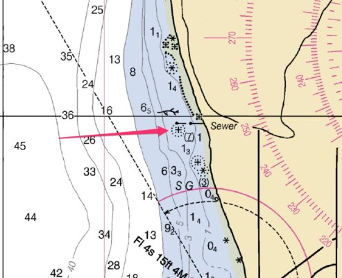
https://adobe.ly/3w0n7As Attached is a screenshot of the NOAA Raster chart of the location.

If my calculations are correct this would have been just after 8pm on Friday Aug 5th, which was just above a 6' tide and within half an hour of sunset. The symbol for the rock I drew the arrow to (just a guess, obviously) means "Rock awash at the level of chart datum" so that could definitely be an unseen but dangerous rock at that tide level.

Please note that this track is not a full depiction of reality. It is only as good as the data the vessel was sending, and the track between data points (which, sometimes confusingly, are not just the places with the arrows marked) is interpolated. It doesn't consider other traffic, etc. The speeds and positions at the arrows should be accurate based on what the vessel reported, however everything between is subject to interpolation (ie. made up).

This is pure speculation, however if I were in that situation I could easily imagine it being late, trying to get in before sunset, and being focused on reviewing the "known dangerous" tricky entrance and thus missing this danger. Again, pure speculation based on me thinking how I could end up in this situation: this is especially true if you are trying to use your primary chart plotter to review the entrance while still underway at 8 knots.
 

Attachments

  • rock.jpg
    rock.jpg
    104.9 KB · Views: 18
Arcturos

Arcturos was the covergirl on Passagemaker Magazine (I think) a few years ago as a new build with an in-depth article. We've seen her around Puget Sound a few times over the last several years.
 
Back
Top Bottom