Transit of Moriches Bay area (New York)

The friendliest place on the web for anyone who enjoys boating.
If you have answers, please help by responding to the unanswered posts.

GB32Patience

Senior Member
Joined
Oct 29, 2020
Messages
117
Vessel Name
Patience
Vessel Make
1978 GB 32 Sedan
Each year we head "East" on our annual 2-3 week getaway out to the East end of Long Island, Block Island, Etc.. Staying on the "inside" the intercoastal route takes us E/W and W/E through the Moriches Bay area. We typically rely on local knowledge from TowBoat US as the local Captain provides great support/direction, we have made the transit the past two years with minimal fuss in our GB32 with 3' 10" draft.... 4'....

Heading out in mid July and will be pinging TowBoat Moriches (left FB message tonite) regarding this year's routing guidance as year to year this area, with strong currents and shifting sand, is very subject to change... will post local conditions as we gain knowledge or actual transit... does anyone have current 2022 knowledge of this area?

Thanks! Patience
 
I’d like to try that route with my Pilgrim 40. Will you be keeping a track with your navigation program?
 
Will do. Will be transiting 7-14/7-15. Have older school Garmin Chartplotter but pretty sure can export tracks. Will post as well as I gain knowledge from TowBoatUS. Are you in the Great South Bay?
 
When I was younger, while my uncle and cousin were clamming in Moriches Bay, I would go scuba diving. I remember there was a "ship wreck" out there that I wanted to dive on. Really just an old wooden runabout that sank. I never did see it though because I could literally put my face mask in the mud at the bottom and the only thing visible was my nose.

Great memories! Hope you have a nice trip, @Patience.
 
I'm in New Bedford Harbor and I transit south to Jacksonville each year.

I'm interested in the route as I usually have to navigate through strong NWers
either going or coming. And the sound can really suck.

Or strong NEers also terrible.

Route also avoids timing Hell's Gate. and the whole East River to Governor's Island traffic zoo.
 
Thanks all for reply and will post status of this passage as we gain information and/or transit on this route. Ah yes... Moriches Bay... whatever your memories, this inlet and bay still has great fresh inflow from the ocean and has the clearest water of any inlet on the south shore of Long island... BTW just had some clams from there this weekend... superb... al in all , in this day... Moriches is still a pristine place ... come on back and check out! :)
Charlie!! Splashing this Thursday!
- Just wrapping up install of Permateek aft deck.. see "GB32 Teak deck" post
- Completing install of new "Full size" electronic head.
- Engine up and running! Repaired manifold, new elbow, new engine and trans oil coolers, new impeller, removed and blown out heat exchanger, removed and reinstalled valvecover and all components striped and painted GB (when they were doing the "marinization") Gold.
- New 58 Gal Mollher Fuel tank refilled with filtered fuel removed from way funkey (removed) fuel tank.
- Finally time for "normal" launching duties, zincs, bottom paint, bilge pumps, etc... Phew... would love to compare more notes as we share the Lehman 120.. and I am finding out more and more.... all good but "stuff to do"..
be well and enjoy your new home port!!!
 
Moriches Bay local routing...

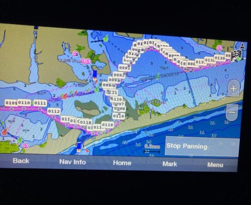
@PMF1984 Well, we had a very pleasant 2 week trip (I know short by many standards but fitting our current lifestyle), East Islip, Moriches Bay, Greenport, Shelter Island, Block Island and home via similar routing through the Moriches Bay area. I had called the local TowBoat US Captain and they advised us that successful routing from the last two years would be successful this season based on the current water depths at high tide. Our strategy has been time our transit to hit the "inlet" area at 1 hour before high tide as the problem area is typically "Harts Cove" East and North of the Inlet where the water gets thin and the markings can be a stick at one point. Our GB32 Sedan officially draws 3'10" but we go with 4'.... on our return trip, we actually hit the area 2 hours before high, with the knowledge that a rising tide would provide some fallback. We also, through the Harts Cove area, crept along at 2-3 Kts... room for a bump... although we had literally inches of water under the keel at times, we made it through with no "bump".... the following image is only a screenshot of our Garmin.. I plotted a route as an aggregate of the "breadcrumbs" from the last two seasons... hence the multiple waypoints needed for granularity.... I am in the process of installing ActiveCaptain on our plotter and will then (I understand) be able to extract the waypoints and routing itself. I'll follow up with that information... send me a PM if you want to chat this route... enjoy!

Moriches Routing.jpg
 
Congrats on a safe and enjoyable trip.

I know a guy who made a bad decision in there despite decades of cruising experience, just a few weeks ago. He was persuaded to change his itinerary on a trip north via the Sound, to go up the coast and in there. He felt he had obtained local knowledge / advice.

His boat is / was a go-fast cruiser. You crept in, and bumped a few times. He made a bad call and in some spot was pushing 20 knots when he hit a bar. The net result was one passenger was airlifted to the hospital with a broken back and jaw, and several others were briefly hospitalized but not as severely.

I mention this because since someone may do a search on this inlet at some point in the future. Do it your way, not his.
 
Moriches Hazards

Very good point @FWT... the inlet itself, only a few years ago we went out with some very local knowledge but vowed never to do so again as the shoaling is so very unpredictable. On the inside, east to west and vice versa...with proper respect for the tide, this route is do-able but very worth noting.. at a velocity that will accomodate a bump and backoff. sorry to hear of this event, but always worth noting the potential. Hopefully those involved recovered... no matter how mays years on the water... always a lesson to be learned.
good note... thank you
 
ActiveCaptain Routing through Moriches Bay

I’d like to try that route with my Pilgrim 40. Will you be keeping a track with your navigation program?

@PMF1984 Please see attached file with my routes contained within. Take a look at the ones named "Moriches Local". You will need "ActiveCaptain" program to reference.

View attachment garmin_export-1.gpx

Let me know how you make out!
 
Moriches Bay Routing 2023

Just an update on the above posted routing. We, Patience, along with "Giddy II" made this transit without any issue in early July of 2023. Target is to transit the area 1-2 hours prior to High Tide at the Moriches Coast Guard. GO SLOW.... 5-7Kts as you dont want to veer off path.... no issue this year with two GB32's with 3'10" of draft... east and west. PM if any questions at all....
 
Back
Top Bottom