Anchorages in Northern BC

The friendliest place on the web for anyone who enjoys boating.
If you have answers, please help by responding to the unanswered posts.
Joined
Aug 5, 2016
Messages
752
Location
USA
Vessel Name
Tortuga
Vessel Make
Nordhavn 63
We are hoping to transit BC to move our boat to Alaska and I'm working on a float plan.

Pending the appropriate approvals, we intend to move through as quickly as we safely can do (80 mile days), and are hoping to stop in secure anchorages and avoid populated areas to the extent possible. I'm familiar enough with the area inside Vancouver Island to plan our stops accordingly. Its the area north of VI that I can use some help with.

We expect to go by the most direct route, which is a fairly well-beaten path. In another year, I would include stops at docks or floats to avoid some sketchy anchorages with mining debris on the bottom, or steep sided small anchorages.

Its the area between Blunden Harbor and Foggy Bay that I'm working on now. Some suggestions for safe anchorages along this path would be helpful and appreciated. We are only stopping to sleep so area attractions are not a factor. Safe, secure, close to the route, and hopefully free of anchor-snagging debris are the qualifications.

thanks
 
How many stops would you like to make between those two points, considering your speed?
 
Some of my favorites for such a transit, starting just before Cape Caution:

Skull Cove

Fury Island Cove

Kisameet Bay

Rescue Bay (be careful going through Jackson Narrows the next morning)

Bottleneck Inlet

Khutze Inlet

Lowe Inlet

Klewnuggit Inlet, Exposed Inlet

Pillsbury Cove (be careful skirting the aquaculture on the way in)

Brundige Inlet

Foggy Bay inner cove
 
Last edited:
You guys are right; my question is too broad to answer. I will narrow it down a bit and ask specific questions if I get stumped. I've made the run before but never with the guidelines we need to follow this time. I tried a few versions but it gets tougher when every stop has to be an anchorage and you are pushing for (reasonably) max miles each day.


RCook, thanks for the list. I will look those up.
 
I do have the guidebooks but there are a huge number of options to check out and every change affects the stop before and/or after.
 
Don't over think it.
If, for whatever reason, you have a 50 mile day, every other day is thrown off and your well intended float plan is scuppered. That plan is for CBSA, RCMP, etc. and is somewhat of an assurance to them, you have chosen the "most direct reasonable route."

Use RCook's stops as a guide and go from there. Almost anywhere, you will be within decent reach of alternatives, which you can scope out on Waggoners before you get there.

Bottom debris shouldn't be a huge worry and again check Waggoners on approach.
 
Why don't you go to marine traffic and follow US flagged boats now heading to Alaska and see where they are overnighting to get ideas where to stop.
 
I do have the guidebooks but there are a huge number of options to check out and every change affects the stop before and/or after.

Your boat is probably big enough to shrug off whatever summer winds you'll see, so you most likely won't have to wait for weather windows in anchorages close to the next big crossing or big body of water like we have to do.

Thinking this way, you probably have the luxury of being able to have a more definitive plan for anchorages. We're always keeping bailout options in mind, because even afternoon winds can make things very uncomfortable very fast in our size of boat.

Maybe you could check out how Washington State commercial fishing boats get to Alaska and what anchorages they prefer. Pretty sure they grind their way through the Inside Passage as efficiently as possible.
 
Why don't you go to marine traffic and follow US flagged boats now heading to Alaska and see where they are overnighting to get ideas where to stop.

Marine Traffic has near zero coverage from Milbanke Sound to Prince Rupert.

Here are some alternates (bailouts) to go along with RCook’s plan.

Shearwater

Wigham Cove

Coghlan Anchorage
 
Last edited:
Great suggestions from everyone, including to not overthink it. I don’t expect a perfect plan but I’m wired to be prepared with planned stops and alternates identified before we head out through unfamiliar territory.

I’ve looked up all the suggested anchorages and added them to my list of stops or alternates. I was having trouble with a couple stretches but now I think I’ve got good possibilities all the way up. Its just a matter of assembling the float plan and that will be much easier now with the additional info I now have.

Our submitted plan will be as optimal as possible and I will have alternates along the way if/when the schedule gets changed by weather or other factors. I mostly wanted to make sure we have good options so we aren’t forced to run at night or stop in a sketchy spot where sleep won’t happen.

Thanks to everyone for the insight and specific suggestions. The cumulative knowledge and experience here on TF is impressive.
 
I'm glad the angst is lessened. Remember, there are hundreds of 7 knot boats, some as small as 28 feet, making this trip in 5-8-10 hour days. Many would give up their favorite whatever, to be in your boots.

You will be just fine.
 
One we have used going north before committing to crossing Chatham Sound to Prince Rupert is a bit north of Oona River, between the top end of Lewis Island and the east side of Porcher Island, through Bloxam Passage.

Barnard Harbor, south end of Whale Channel also came in handy. We stopped very abruptly while backing down on our anchor there. Thought we were going to lose our anchor to some massive ancient waterlogged spruce log/root ball, but it came up easy.

Both these spots are good for bigger boats and the anchorages have flattish bottoms.
 
We completed this passage last week. Our stops north of Pt McNeill were:


1. Codville Lagoon
2. Bottleneck Inlet
3. Lowe Inlet
4. Brundige Inlet


All of these worked well for us with good protection and holding.


We initially planned for shorter legs and a longer passage but once underway you realize that since you aren't able to leave your boat there isn't much reason to get to an anchorage early, so we averaged 9-10 hours days at 8 - 8.5 knots.


Fortunately we didn't encounter any weather delays. Good luck with your trip.
 
63 is too big for a couple of my fav's, Miles Inlet and Walker Group (Kent/Staples Islands). I find Miles really convenient riding an afternoon tide out the strait and slipping past Slingsby with the morning flood. Blunden is a good choice for a big boat. If not N/NW wind Jones Cove (SW Smith Snd) is good, anchor just inside the rocks off the point, beautiful view in the sunset light. Millbrook Cove (NW Smith) is a regular stop, use caution approaching in a big boat, avoid the north part inside, it shallows up sooner than you'd expect. Further up the line Green Island Anchorage is a good one. At the top of Fitz Hugh Long Point Cove is a convenient stop (not in outflow winds tho). Just past Bella Bella Ormidale Hbr is good anchorage for large boats. These are secure spots close by the route, mostly easy in and out. Wigham Cove is a couple miles out of the way but an excellent anchorage, especially the south cove. If you're not wary about transiting Reid Passage (Ivory Is) in a big boat, Oliver Cove is a good stop. Rescue Bay is a good stop but about 3 miles out of the way of the most direct route.
 
We completed this passage last week. Our stops north of Pt McNeill were:


1. Codville Lagoon

Curious about Codville Lagoon. Last time up there, we dragged our anchor all over the west cove before getting a dubious set. There were a couple of boats close to the north shore of that cove who seemed to have no problem but filled that space. 2 other boats came in after us and similarly made many attempts before setting, one of them dragged in the night and had to move.

Where in Codville is the good bottom? North cove?
 
I've anchored in the east area of Codville. It was windblown, that day at least, and I wasn't impressed. There might be better cover at the north end although it's deeper. A far better spot nearby is Fancy Cove, on the south side of Lama Passage. Can't help with Codville's bottom and holding.
 
Last edited:
63 is too big for a couple of my fav's, Miles Inlet and Walker Group (Kent/Staples Islands). I find Miles really convenient riding an afternoon tide out the strait and slipping past Slingsby with the morning flood. Blunden is a good choice for a big boat. If not N/NW wind Jones Cove (SW Smith Snd) is good, anchor just inside the rocks off the point, beautiful view in the sunset light. Millbrook Cove (NW Smith) is a regular stop, use caution approaching in a big boat, avoid the north part inside, it shallows up sooner than you'd expect. Further up the line Green Island Anchorage is a good one. At the top of Fitz Hugh Long Point Cove is a convenient stop (not in outflow winds tho). Just past Bella Bella Ormidale Hbr is good anchorage for large boats. These are secure spots close by the route, mostly easy in and out. Wigham Cove is a couple miles out of the way but an excellent anchorage, especially the south cove. If you're not wary about transiting Reid Passage (Ivory Is) in a big boat, Oliver Cove is a good stop. Rescue Bay is a good stop but about 3 miles out of the way of the most direct route.


Miles is also one of my favorites, I've been in there when there have been some stick boats larger then 60. I suspect if you haven't been in there before it might be a little bit of a pucker factor the first time you enter it.


Jones cove has some foul areas in it I suspect it at one time was used to store log rafts. I much prefer fly basin a couple of miles further down Smith as long as you have good charts there are no issues getting in and out of there.
 
Sorry I said west and meant "the other west" (east). Thanks for the tip on Fancy Cove - I'll check that next time.
 
Fancy Cove can be uncomfortable with a NW wind getting in there. For large boat, Anchor Bight is a lot easier than Fly Basin.
 
Curious about Codville Lagoon. Last time up there, we dragged our anchor all over the west cove before getting a dubious set. There were a couple of boats close to the north shore of that cove who seemed to have no problem but filled that space. 2 other boats came in after us and similarly made many attempts before setting, one of them dragged in the night and had to move.

Where in Codville is the good bottom? North cove?
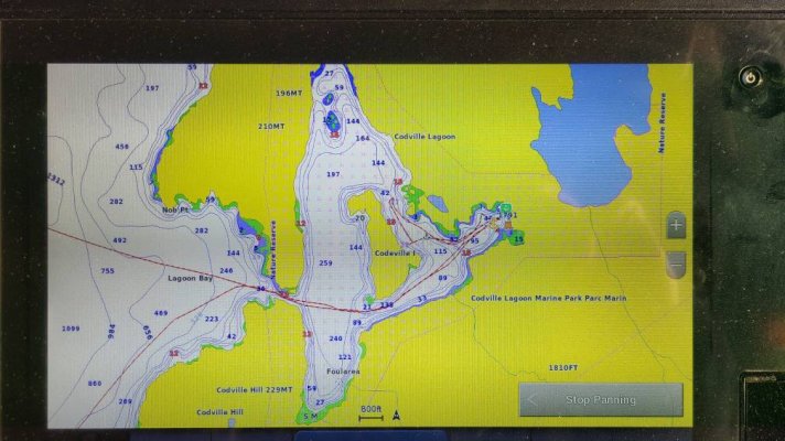
We entered Codville just as some weather caught up with us, so we anchored in driving rain and strong wind.

After trying the east cove we moved looking for more protection just as the wind decided to change direction. We ended up back in the east cove shown at yellow anchor location below.

The holding was good throughout the night. 20210519_053443.jpeg
 
There's a good spot for N or W wind at the N end of Codville, N of the small island.
 
I can confirm that the north end of Codville Lagoon DOES NOT have consistently good holding throughout. When we were there about 5 days ago, we were in the center of that cove and when we set (or tried to) the anchor we could feel it scraping across what sounded like a very very large flat smooth rock bottom. We got a “good enough” hold for the conditions, but not enough to be confident in any sort of blow.

Still, Codville Lagoon is beautiful and we’ll definitely go back - and look for a good set somewhere.
 
I just returned from the transit north from LaConner to Hoonah. I sent in my transit plan ahead of time and also had a transit plan printed to hand to the customs officer. They are not too concerned about staying where you chose to stay. They are more concern that your transit is as expediant as possible. Some of the anchorages suggested are now closed, such as Bottleneck & Kynoch. Check before you leave. You may call ahead for groceries. We did with the IGA in Port McNeill, delivered to the fuel dock. I also called US Cusoms and they suggested that if you use CBP Roam that you check in from Prince Rupert (better coverage). We did this and that was it! There is a new app coming out for CBP so check to make sure that you are up to date. The same will be required when heading home.
 
Re CBP Roam: both of us onboard have NEXUS, but we were nonetheless instructed to use the ROAM app to clear into Canada when we called from Prince Rupert.

We tried repeatedly to submit our application for entry through the app, starting from the time we left Prince Rupert. For us, the app would not accept the submission until we were almost directly on top of the border.
 
I can confirm that the north end of Codville Lagoon DOES NOT have consistently good holding throughout. When we were there about 5 days ago, we were in the center of that cove and when we set (or tried to) the anchor we could feel it scraping across what sounded like a very very large flat smooth rock bottom. We got a “good enough” hold for the conditions, but not enough to be confident in any sort of blow.

Still, Codville Lagoon is beautiful and we’ll definitely go back - and look for a good set somewhere.

That is what we got in the east cove of Codville. Could feel the anchor chain, anchor was simply sliding along rock. On about the 5th attempt, we got it to catch something which held though the night.
 
I checked my charts, and I now realize that our “rock bottom” experience was also in the east cove of Codville Lagoon. When we were there, there was a fishing boat anchored to the northwest of the central island, in the passage between the north and east coves. We’ll try there on our next visit.
 
Back
Top Bottom