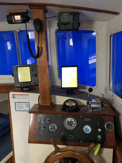
Upgraded Electronics

The friendliest place on the web for anyone who enjoys boating.
If you have answers, please help by responding to the unanswered posts.
Greetings,
Mr. k. Welcome aboard if I've missed you. I second all of the above. Keep in mind the "biggest and the best" will be out of date (considered "old" electronics) in a couple of years.


We have an entry level GPS/plotter (Garmin 560S, I think) on board that does everything WE want it to. I don't even use a lot of the features. Just want to see where I am and what the depth is. Older radar and autopilot (both work). VHF, as well.


As mentioned, YOUR needs will depend on what you want.
The best will be out of date in two years? Perhaps, but that belies the fact that this same equipment will continue to do a fine job for many years in its original form. I think what is forgotten is that the MFDs that have been marketed in the last five-seven years are of such high quality and clarity that subsequent improvements have only been marginal and will continue to be so. Couple that with manufacturer updates to operating software, what results is an MFD that is quite useful for many, many years.

I navigate with an MFD and two tablets. I like having a 12-inch screen right in front of my eyes that displays charts, depth, and a radar overlay if I choose all at a glance. I and my wife use the tablets with two different charting programs on each, Navionics and Aquamaps. A phone is too small for my taste, way to much opportunity to miss something and constant expanding and contraction of the screen. I would not feel safe operating that way.
 
Electronics onboard the 48' trawler I am purchasing:

Radar: Raymarine C120
Depth Sounder: Unknown mfg.
Autopilot: Simrad AP11
GPS: Raymarine C70
VHF: Icom M602
Compas: Uknown mfg.

With simplicity in mind...I'm open to suggestions...New chart plotter, AIS, advanced radar, VHF and depth sounders are in my bucket list...I need help with the rest...

Some items will need to be duplicated on the flybridge...Yes?


If they all work, and if the Raymarine C70 is also a plotter?, I think you're good to go.

Use the boat for a while, let it tell you what else -- if anything -- you might need and/or just want. The way you end up using the boat, for example, may well dictate what (if anything) you might eventually want installed on the flybridge.

Maybe augment with a tablet app and a handheld VHF in the meantime, both of which will be useful no matter what else you eventually do.

Two schools of thought: buy all nav equipment from one manufacturer (plus radios from ICOM or Standard Horizon), or buy best-in-class for each individual unit. Pros and cons for each approach.

And then you can take into account what you've already got. (Some of) Your existing stuff could make fine backups, for example (even move it around if necessary)... and/or you could build a full suite based on Raymarine or Simrad units to extend what you have now.

Et cetera...

-Chris
 
I think it depnds a lot on what your cruising plans are. For example, Charlie O going up the Hudson to Lake Champlain, it would be hard to get lost or get in much trouble with just a set of charts. Good to have depth and handheld VHF, but you don't need a lot of sophisticated equipment for a trip like that.
 
Yep! More info...........

As to ethernet, I see it replacing N2k over time. Its bandwidth and speed is far greater. But N2k being a bus type network that has its advantages too. Great for smaller boats! Once you get into the 40+ footers, you are running ethernet between wheelhouse, flybridge and radar at a minimum. Just waiting to see what's coming down the pipe. Look at CZone for example?

Iggy,

OneNet is the new NMEA standard that will probably come on line next year. I attended four work shops conducted by NMEA in September. I think cruisers and vendors will drive the change. The chartplotters and radar I purchased have those connections.

I was surprised to find out that most commercial boats are still for the most part outfitted with 0183 cabling.
 
If they all work, and if the Raymarine C70 is also a plotter?, I think you're good to go.

Use the boat for a while, let it tell you what else -- if anything -- you might need and/or just want. The way you end up using the boat, for example, may well dictate what (if anything) you might eventually want installed on the flybridge.
Sound advice! :popcorn:
 
New auto-pilot $4,500, new chart-plotter $1,200, new vhf radio $300, new AIS transponder $700, plus what ever you want. Good luck - oh, forgot the radar
 
Iggy,

OneNet is the new NMEA standard that will probably come on line next year. I attended four work shops conducted by NMEA in September. I think cruisers and vendors will drive the change. The chartplotters and radar I purchased have those connections.

I was surprised to find out that most commercial boats are still for the most part outfitted with 0183 cabling.

Thank you for the response. I did a little reading on OneNet and a little confused by it. It uses IP protocol and POE. But why use IP6 and make it more confusing over IP4. But I am no expert and not seeing the real deference between OneNet and the ethernet that we all know.
 
Thank you for the response. I did a little reading on OneNet and a little confused by it. It uses IP protocol and POE. But why use IP6 and make it more confusing over IP4. But I am no expert and not seeing the real deference between OneNet and the ethernet that we all know.

I don’t think there will be much of a difference. NMEA is the standards organization. If they didn’t address and develop standards across the electronics industry for it, no one would, which would be a net loss for the consumer.

The interesting thing to me is what it will mean for marine electronics. It is a bigger “pipe”. So, much more information will flow across it than N2K (CanBus architecture) can permit. Easy answers are more inbound feeds to chart plotters from more and more information access points.

However, until the industry figures out how to make real time information from the internet more readily available, to mesh with the on board data, I just don’t see an explosive change in the amount of information moving through the system.

If I let my imagination run wild, the capability to overlay weather, and shipping data, fuel prices, port conditions, and other info on the net, would allow for more situational knowledge, and would perhaps up the safety of previously disconnected marine transit. At the same time, I am concerned about the tools becoming so esoteric, that any complications to the system will require expensive tools, specially trained techs, etc. to troubleshoot, kind of like the automotive industry today.

As far as using IP6, I think they are just incorporating that because many expect that the entire net will eventually be there anyway.

Interesting times!
 
Talk about electronics getting updated. A couple of months ago I ordered a new suite of Raymarine electronics. I got the new Quantum 2 radar. UPS delivered it and the very next day I get an email from Raymarine that they have a new radar out…. Of course.
 
All electronics are outdated as soon as they come out.
 
I don’t think there will be much of a difference. NMEA is the standards organization. If they didn’t address and develop standards across the electronics industry for it, no one would, which would be a net loss for the consumer.

The interesting thing to me is what it will mean for marine electronics. It is a bigger “pipe”. So, much more information will flow across it than N2K (CanBus architecture) can permit. Easy answers are more inbound feeds to chart plotters from more and more information access points.

However, until the industry figures out how to make real time information from the internet more readily available, to mesh with the on board data, I just don’t see an explosive change in the amount of information moving through the system.

If I let my imagination run wild, the capability to overlay weather, and shipping data, fuel prices, port conditions, and other info on the net, would allow for more situational knowledge, and would perhaps up the safety of previously disconnected marine transit. At the same time, I am concerned about the tools becoming so esoteric, that any complications to the system will require expensive tools, specially trained techs, etc. to troubleshoot, kind of like the automotive industry today.

As far as using IP6, I think they are just incorporating that because many expect that the entire net will eventually be there anyway.

Interesting times!

It all sound interesting. Even right now, my MFDs are both using N2k and ethernet to make everything work together. Would love to cut down the wiring, but than hub/switches would be needed. Interesting to see how this would be done!

As far as IP6, just like many home devices. They support it but its not being used. POE will be a great advantage too. Running one wire vs two
 
All electronics are outdated as soon as they come out.

Well, some of it is marketing. But I think, and who am I! That every 5 to 6 years, what you now have is outdated to the new stuff. But the other side to this, does that old device work well and does the new stuff work even better to make it worth having?

I general wait for the 2nd to 3rd model up before upgrading. To upgrade to the next model up, general speaking, the advantages are small and the bang per dollar to what you gain is small.
 
I think, like computers, that capabilities are nearing a point where chart plotters become commodities. Along with tablets and phones using navigation software, it seems to me that “single purpose” hardware will continue to die out, over time. If that is true, then folks won’t be putting multiple displays of. Arming sizes and types on their helms, which means that a lot of folks will need to resurface their helms prior to replacing equipment, on the flybridge, I am just going with a single interface chart plotter, while on the interior helm, I will have a cp, ap, and engine display.

The other variable is PGN definitions and the management of those. NMEA controls those, while manufacturers can add new ones, test them, and have them approved. There are a couple of spots in a PGN that can be custom for a manufacturer, but the definition and presentation to the system is controlled. With the much greater bandwidth available, will that change? If so, I don’t think different manufacturers systems will talk with one another as well as they do now.
 
There’s so much information a human can process at one time. There’s a point where information over load can decrease your performance. So when looking at new protocols you potentially run the risk of screen hypnosis. Even now screen hypnosis is a real risk for many. Increasing processing speed by nanoseconds is meaningless to me. Increasing the size of pipe hits a point where it doesn’t make any meaningful contribution to safe navigation.
When underway I want a screen telling me the information I want to stay safe and operate efficiently. Although my current new simrad system allows me to look at weather and do multiple other things by decision don’t use those features. Rather want whoever is on watch looking for safety issues and maximizing performance. We use other screens when those things (fuel prices, dockage, points of interest, music etc) are wanted.
Know cruisers including circumnavigators who get by with an IPad. Know others who have dedicated computers running nav and monitoring programs . Both have eschewed MFDs at opposite ends of the spectrum. I still like MFDs. Wish manufacturers spent less time on bells and whistles and more on hardening their system, improving service life and decreasing cost. Not tech aversive. Voice commands and heads up displays might be quite helpful.
 
Last edited:
Hippocampus

Increase "YOUR" CPU and memory:)


I am only kidding
 
Last edited:
There’s so much information a human can process at one time. There’s a point where information over load can decrease your performance. So when looking at new protocols you potentially run the risk of screen hypnosis. Even now screen hypnosis is a real risk for many. Increasing processing speed by nanoseconds is meaningless to me. Increasing the size of pipe hits a point where it doesn’t make any meaningful contribution to safe navigation.
When underway I want a screen telling me the information I want to stay safe and operate efficiently. Although my current new simrad system allows me to look at weather and do multiple other things by decision don’t use those features. Rather want whoever is on watch looking for safety issues and maximizing performance. We use other screens when those things (fuel prices, dockage, points of interest, music etc) are wanted.
Know cruisers including circumnavigators who get by with an IPad. Know others who have dedicated computers running nav and monitoring programs . Both have eschewed MFDs at opposite ends of the spectrum. I still like MFDs. Wish manufacturers spent less time on bells and whistles and more on hardening their system, improving service life and decreasing cost. Not tech aversive. Voice commands and heads up displays might be quite helpful.

I think your approach is the right one, and one I endorse, though it may not be the most popular one amongst boaters. In the mad rush to sell more features, will the manufacturers, and the NMEA make the level of information flow less safe? I think they will. I need depth, gps info, speed and course, and in lower light conditions, radar. I need the ability to communicate safely. I like AIS. Those parameters largely satisfy immediate navigational needs while motoring. Of course, for planning I need more, but not when motoring along.
 
You may also look into a multiplexing system that can combine your 0183 information, AIS and GPS and transmit it on a WiFi network throughout your boat. I have done this and use an iPad running iSailor. The beauty of this is you can view on multiple devices anywhere onboard.

I do have a stand alone radar with the display at the lower helm. The depth finder and electronic compass remain as backup.

IMG_5688.jpg
 
Last edited:
I just installed a new Furuno system with 16" MFD, high end transducer, special satellite compass with four antennas, 48 mile radar, autopilot, chart plotter, fish finder, maps, depth finder, etc. Just north of $16,000 installed.

I could have spent much less buy buying a regular flux gate compass, smaller radar, simple transducer, and smaller MFD.

I love the speed and accuracy of the satellite compass. My radar can see a seagull swimming past the boat, the 16" screen is great but 12" would have been fine, I don't fish at 2,500 feet so I could have saved several hundred dollars on a cheaper transducer. The fish finder software and chart plotter software come with the MFD. The transducer selected allows for varying capabilities and you spend what you want to unlock pre-loaded maps.
 
We are in the process of upgrading ours. Some of the equipment can be used, others no. Adding AIS, new auto helm, replacing depth sounder.
I am expecting somewhere in the $15 k range.
 
In the scheme of things and boating expenses, $15K or so for a new suite of of the latest electronics does not sound too bad to me and certainly adds to re-sale value if that's in your plans in the next few years.
 
I agree with most of the above. However, if you're going to do any offshore at all, or coastal where there is fog, I would want at least a minimal modern radar and an AIS transceiver.


I also like very much using a satellite compass, particularly if you have bridges, tunnels, or locks in your path -- it's ability to ignore steel around you is comforting when the water is swirling around a bridge. When we first got Fintry, she would turn 45 degrees to starboard when we crossed the Ted Williams tunnel in Boston Harbor. The satellite compass cured that.


I have used OpenCPN -- freeware -- as my principal char plotter on both Fintry and Morning Light. I like it much better than any of the commercial chart plotters, most of which I have used.


Jim
 
New Electronics

We installed all new Garmin components last year.
2-8610 10" Chartplotters
24" Fantom Radar
AIS transceiver
Sonar thru hull transducer
Autopilot
2- VHF/GPS enabled Radio
Misc network interface connections
$15000 this was the price for equipment everywhere we checked (Hamiltons, West Marine, etc)
$5000 Labor....including seatrial, training

All worth it's weight in gold....reduction in navigational stress=priceless

Happy Holidays
Mike Dana
Third Reef
36'Grand Banks Classic
Potts Harbor Maine
 
I agree with most of the above. However, if you're going to do any offshore at all, or coastal where there is fog, I would want at least a minimal modern radar and an AIS transceiver.


I also like very much using a satellite compass, particularly if you have bridges, tunnels, or locks in your path -- it's ability to ignore steel around you is comforting when the water is swirling around a bridge. When we first got Fintry, she would turn 45 degrees to starboard when we crossed the Ted Williams tunnel in Boston Harbor. The satellite compass cured that.


I have used OpenCPN -- freeware -- as my principal char plotter on both Fintry and Morning Light. I like it much better than any of the commercial chart plotters, most of which I have used.


Jim

Never had that problem crossing the Ted Williams Tunnel. Interesting?

Ether on my boat and driving or crewing on a ferry that goes right over that tunnel for the past 4 years. I would love to know way that happens to you. The depth in that area is in the 45 to 50' range. The air port radar is about 1/4 mile away opposite Castle Island. Now that I have seen cell interference every time we get close to it.

For what it's worth, the ferry uses a Garmin and I have Simrad electronic compass.
 
Last edited:
I agree with most of the above. However, if you're going to do any offshore at all, or coastal where there is fog, I would want at least a minimal modern radar and an AIS transceiver.


I also like very much using a satellite compass, particularly if you have bridges, tunnels, or locks in your path -- it's ability to ignore steel around you is comforting when the water is swirling around a bridge. When we first got Fintry, she would turn 45 degrees to starboard when we crossed the Ted Williams tunnel in Boston Harbor. The satellite compass cured that.


I have used OpenCPN -- freeware -- as my principal char plotter on both Fintry and Morning Light. I like it much better than any of the commercial chart plotters, most of which I have used.


Jim

I like the idea of the unparalleled accuracy of a satellite compass in general but have a hard time understanding the concern with a fluxgate going crazy near bridges. The concern you cite suggests that the boat is on autopilot when going underneath a bridge. Many are narrow and have challenging currents as you mentioned. That is not something I would do. Nor would I be on autopilot when approaching a lock. Am I missing something? It is curious about passing over the Ted Williams Tunnel.
 
Find the reports of compass difficulties interesting. Know multiple long distance cruisers who have gone to standalone very simple APs not integrated into the nav system after bad experiences.
We had rare difficulties with our prior RM system. On rare occasions ( 1-3 times a year) the AP would decide to do a 360. Watch would hit standby so other than a rare gybe no harm done. Never figured out why that would happen even with techs burning boat bucks after our unsuccessful attempts to personally troubleshoot it.
Don’t know enough to say if satellite compass would eliminate that risk. Do think there’s been occasions where it seems our gps signal has been degraded. Go to screen showing number of satellites and it’s fallen or see our position jump on the chart screen. Have thought that’s due to nearby military activity, atmospherics (lightening etc.) or something I don’t understand.
Think the most important button on the AP is standby.
 
I have a fluxgate compass on my AP and it is not affected by steel bridges.

Most of the bridges here in the PNW cross large bodies of water so using AP under them is not an issue. Though as someone mentioned, I prefer hand steering when the waterway narrows.
 
2 years ago, I bought a Simrad bundle with 4g radar, 9 inch MFD, and a basic transducer. $5k (there are less expensive options that are not as expandable, plus I wanted a knob input on MFD vs touchscreen.

So what do you think of the performance of that 4G radar, both short and long range?
 
So what do you think of the performance of that 4G radar, both short and long range?
Although I've run a lot of radar, tough for me to compare. My radar is fine for 6 miles which is what I typically run when coastal (I normally run offset, so about 9 nm in front, 3 behind). Inside that range is very good. Guessing it doesn't pickup storms 15-20 miles away like a decent open array would.i can't speak to how it does when I zoom out periodically to scan horizon.

I thought about a high power open array. The expense vs benefit didn't pencil out for me. If all the threads on radar and electronics, I don't recall one discussing the comparative benefits of a 72-nm radar. I know bigger is better. But it's also a LOT more expensive. Wonder what the benefit is for coastal passage making say, headed down coast of Baja.

Peter
 
Back
Top Bottom