You are using an out of date browser. It may not display this or other websites correctly.
You should upgrade or use an alternative browser.
You should upgrade or use an alternative browser.
Navionics Boating app no longer shows current station
- Thread starter ScottRhodes13
- Start date
The friendliest place on the web for anyone who enjoys boating.
If you have answers, please help by responding to the unanswered posts.
If you have answers, please help by responding to the unanswered posts.
SteveK
Guru
- Joined
- Jul 5, 2019
- Messages
- 5,082
- Location
- Gulf Isalnds BC canada
- Vessel Name
- Sea Sanctuary
- Vessel Make
- Bayliner 4588
look in the menu, on mine tide and then current, before it was on when started, today I had to go to menu to turn on, try thatMine shows tide, as it always did, but still no current.
Portage_Bay
Guru
- Joined
- Oct 19, 2015
- Messages
- 2,457
- Location
- United States
- Vessel Name
- Pacific Myst
- Vessel Make
- West Bay 4500
Does it turn current predictions on for Deception Pass? Or for your present location? I'm sitting ashore on the Oregon coast in Manzanita. When zoomed into Deception Pass and I go to the menu to turn currents on Navionics pans to the Oregon coast and gives a menu of near to me current predictions. I can then pan to other areas and in most places see current. However currents for Deception Pass are still not shown.look in the menu, on mine tide and then current, before it was on when started, today I had to go to menu to turn on, try that
klee wyck
Guru
- Joined
- Feb 8, 2014
- Messages
- 987
- Location
- USA
- Vessel Name
- Domino and Libra
- Vessel Make
- Malcom Tennant 20M and Noordzee Kotter 52
Does it turn current predictions on for Deception Pass? Or for your present location? I'm sitting ashore on the Oregon coast in Manzanita. When zoomed into Deception Pass and I go to the menu to turn currents on Navionics pans to the Oregon coast and gives a menu of near to me current predictions. I can then pan to other areas and in most places see current. However currents for Deception Pass are still not shown.
Exactly my experience.
It will show currents for areas of low consequence but for areas that I frequent where it really matters like Deception Pass and the Port Townsend Canal, it will not show a current from where I sit.
SteveK
Guru
- Joined
- Jul 5, 2019
- Messages
- 5,082
- Location
- Gulf Isalnds BC canada
- Vessel Name
- Sea Sanctuary
- Vessel Make
- Bayliner 4588
Does it turn current predictions on for Deception Pass? Or for your present location? I'm sitting ashore on the Oregon coast in Manzanita. When zoomed into Deception Pass and I go to the menu to turn currents on Navionics pans to the Oregon coast and gives a menu of near to me current predictions. I can then pan to other areas and in most places see current. However currents for Deception Pass are still not shown.
Yes, it is 43 nautical miles from me, I click on deception island and it jumps there showing current speed and direction. But it is not under the bridge or in the pass, but at the mouth.
Current predictions I do not see on the computer, but there is one on the smartphone that you can scroll to the time of day you want.
Last edited:
klee wyck
Guru
- Joined
- Feb 8, 2014
- Messages
- 987
- Location
- USA
- Vessel Name
- Domino and Libra
- Vessel Make
- Malcom Tennant 20M and Noordzee Kotter 52
Yes, it is 43 nautical miles from me, I click on deception island and it jumps there showing current speed and direction. But it is not under the bridge or in the pass, but at the mouth.
Current predictions I do not see on the computer, but there is one on the smartphone that you can scroll to the time of day you want.
Yeah, this is how you get in trouble.....
That station that Navionics call Deception Island (not Deception Pass) is actually out in Rosario Strait which is just a couple of miles from the actual Deception Pass. It shows a slack tomorrow morning at 8:48 AM. At that time Deception Pass itself will be running around 6 knots if you believe TidesNear Me. Ayetides and Realtides agree.
I guarantee you that you do not want to be in there with a slow boat at that time.
Deception and others like it are a hair trigger. You do not want to miss by 20 minutes on a big swing. I respect Navionics for removing it from the app if it was not accurate. There are other resources.
Last edited:
Hurray!
I now have both Deception and Skookumchuk!
I now have both Deception and Skookumchuk!
SteveK
Guru
- Joined
- Jul 5, 2019
- Messages
- 5,082
- Location
- Gulf Isalnds BC canada
- Vessel Name
- Sea Sanctuary
- Vessel Make
- Bayliner 4588

MichaelD
Veteran Member
Does it turn current predictions on for Deception Pass? Or for your present location? I'm sitting ashore on the Oregon coast in Manzanita. When zoomed into Deception Pass and I go to the menu to turn currents on Navionics pans to the Oregon coast and gives a menu of near to me current predictions. I can then pan to other areas and in most places see current. However currents for Deception Pass are still not shown.
I think the surrogate tide/current station for Deception Pass is the one at Yokeko Point, which is quite close, although in a wider channel so probably will under-report the strength of current for DP.
La Conner currents are very tricky to predict. An app called My Tide Times has predictions. I don't know how good they are.
klee wyck
Guru
- Joined
- Feb 8, 2014
- Messages
- 987
- Location
- USA
- Vessel Name
- Domino and Libra
- Vessel Make
- Malcom Tennant 20M and Noordzee Kotter 52
Now it is back, even the station right at the pass, and this time there is greater agreement between the four apps I look at compared to before when Navionics tended to be an outlier.
Hope it sticks because I agree that it is convenient to have it on a chart I am looking at anyway rather than opening another app.
If it is accurate......
Hope it sticks because I agree that it is convenient to have it on a chart I am looking at anyway rather than opening another app.
If it is accurate......
OP
OP
ScottRhodes13
Member
- Joined
- Nov 16, 2021
- Messages
- 22
- Vessel Name
- Wanda June
- Vessel Make
- Atlas Pompano 21
Now it is back, even the station right at the pass, and this time there is greater agreement between the four apps I look at compared to before when Navionics tended to be an outlier.
Hope it sticks because I agree that it is convenient to have it on a chart I am looking at anyway rather than opening another app.
If it is accurate......
Hmm. I'm still not seeing current tables for Deception Pass, Skagit Bay, or Port Townsend Canal on my Navionics Boating app. I see current tables for other areas. I even tried uninstalling and reinstalling the app.
SteveK
Guru
- Joined
- Jul 5, 2019
- Messages
- 5,082
- Location
- Gulf Isalnds BC canada
- Vessel Name
- Sea Sanctuary
- Vessel Make
- Bayliner 4588
There is none inside the pass
klee wyck
Guru
- Joined
- Feb 8, 2014
- Messages
- 987
- Location
- USA
- Vessel Name
- Domino and Libra
- Vessel Make
- Malcom Tennant 20M and Noordzee Kotter 52
There is none inside the pass
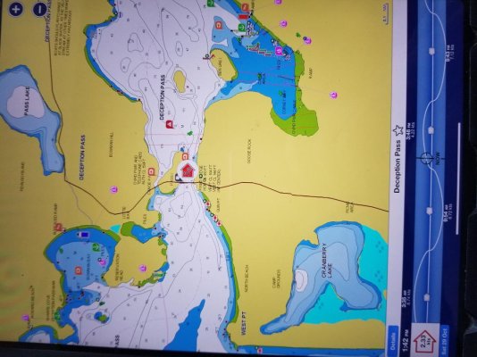
Here is what I am getting and have been getting for the last couple of days. It was gone for a while before that but now back to what displayed previously except now seems more accurate.
I have the subscription form of Navionics on an Ipad Pro (and not the InavX version.
If you zoom in on the chart to look at Deception Pass or the PT Canal now, the red or blue arrow shows up (flood or ebb). If you click on the arrow, the real time current speed and direction shows up on the now enlarged arrow and then the predictions of past and future currents show up at the bottom f the chart. You can scroll on that prediction graph to futures days and times for route planning.
I hope this photo of the chart screen shows up decent. I would apologize for the sideways picture but what I really think is that it is well past time for the forum owners to apologize for how poorly their software works with photos and do something about it.....I know of no other software that gives me this kind of trouble and I refuse to make work out of this.
Attachments
SteveK
Guru
- Joined
- Jul 5, 2019
- Messages
- 5,082
- Location
- Gulf Isalnds BC canada
- Vessel Name
- Sea Sanctuary
- Vessel Make
- Bayliner 4588
Well this is odd. Neither my phone or laptop version shows what you have displayed.
I have the subscription and logged in, still no current.
I have the subscription and logged in, still no current.
Last edited:
Portage_Bay
Guru
- Joined
- Oct 19, 2015
- Messages
- 2,457
- Location
- United States
- Vessel Name
- Pacific Myst
- Vessel Make
- West Bay 4500
I have a subscription on the Android app. Current predictions for Deception Pass are still absent. Current predictions for near by passes and channels are showing and behave as you describe. Not terribly important to me because my primary nav app is Coastal Explorer on the PC. Main backup is OpenCPN on the tablet. I use Navionics for long distance rough draft route planning and backup to the backup.Here is what I am getting and have been getting for the last couple of days. It was gone for a while before that but now back to what displayed previously except now seems more accurate.
I have the subscription form of Navionics on an Ipad Pro (and not the InavX version.
If you zoom in on the chart to look at Deception Pass or the PT Canal now, the red or blue arrow shows up (flood or ebb). If you click on the arrow, the real time current speed and direction shows up on the now enlarged arrow and then the predictions of past and future currents show up at the bottom f the chart. You can scroll on that prediction graph to futures days and times for route planning.
I hope this photo of the chart screen shows up decent. I would apologize for the sideways picture but what I really think is that it is well past time for the forum owners to apologize for how poorly their software works with photos and do something about it.....I know of no other software that gives me this kind of trouble and I refuse to make work out of this.

SteveK
Guru
- Joined
- Jul 5, 2019
- Messages
- 5,082
- Location
- Gulf Isalnds BC canada
- Vessel Name
- Sea Sanctuary
- Vessel Make
- Bayliner 4588
I am 48 nautical miles away, how far are you Klee wyck?
Maybe you need to be within a certain distance.
Maybe you need to be within a certain distance.
klee wyck
Guru
- Joined
- Feb 8, 2014
- Messages
- 987
- Location
- USA
- Vessel Name
- Domino and Libra
- Vessel Make
- Malcom Tennant 20M and Noordzee Kotter 52
I am 48 nautical miles away, how far are you Klee wyck?
Maybe you need to be within a certain distance.
I am 200+ miles away in the desert on dry land. It still is working as I type.
RedRascal
Senior Member
Just update my charts after seeing this thread and no Deception Pass or Port Townsend canal currents for me. I am showing currents in other waters to the north and south. This is on an android phone and I tried it with GPS off and on. Also restarted the app and rebooted the phone. Didn't check on my tablet but that is android too.
Seems like if you will be going through some critical passages you can't count on navionics and need another source.
Seems like if you will be going through some critical passages you can't count on navionics and need another source.
SteveK
Guru
- Joined
- Jul 5, 2019
- Messages
- 5,082
- Location
- Gulf Isalnds BC canada
- Vessel Name
- Sea Sanctuary
- Vessel Make
- Bayliner 4588
Then it has to do with Ipad Pro. On my search I find that Android version does not have anchor drag either. I bet they are re writing software and this will return to all platforms.I am 200+ miles away in the desert on dry land. It still is working as I type.
MichaelD
Veteran Member
There's a real mystery here.
The two Garmin products, Active Captain and Navionics, seem to mostly not have Deception Pass currents. Except sometimes they do.
AyeTides does.
MyTideTimes does not.
NOAA tables does.
Further, comparing event timing and magnitude, currents and tides, among the various apps at common stations, there are differences, sometimes significant e.g. up to 20 minutes difference in Slack time.
For much of the US coast, this isn't too big an issue. For some places, such as the Salish Sea, its a big deal. Hence our local Power Squadron
(America's Boating Club of the San Juan islands, https://abcsji.org) is developing a localised seminar on electronic navigation in these waters.
Last edited:
klee wyck
Guru
- Joined
- Feb 8, 2014
- Messages
- 987
- Location
- USA
- Vessel Name
- Domino and Libra
- Vessel Make
- Malcom Tennant 20M and Noordzee Kotter 52
There's a real mystery here.
The two Garmin products, Active Captain and Navionics, seem to mostly not have Deception Pass currents. Except sometimes they do.
AyeTides does.
MyTideTimes does not.
NOAA tables does.
Further, comparing event timing and magnitude, currents and tides, among the various apps at common stations, there are differences, sometimes significant e.g. up to 20 minutes difference in Slack time.
For much of the US coast, this isn't too big an issue. For some places, such as the Salish Sea, its a big deal. Hence our local Power Squadron
(America's Boating Club of the San Juan islands, https://abcsji.org) is developing a localised seminar on electronic navigation in these waters.
To further complicate things and by way of an update, the current information and predictions for DP and the PT canal have again disappeared from Navionics on my IPad.
tiltrider1
Guru
- Joined
- Aug 2, 2017
- Messages
- 4,358
- Location
- Pacific North West
- Vessel Name
- AZZURRA
- Vessel Make
- Ocean Alexander 54
When this thread started. I went to my navionics, zoomed in on Deception pass, saw the arrow and clicked on it, up popped the current chart. I then posted a comment that I still had the currents but that I was on an Apple OS. Yesterday, I pulled up Navionics and low and behold, the current arrow is gone.
Obviously, they updated android and some time later updated Apple. Why? Don’t know. I can confirm that the arrow was definitely there not long ago it has ceased to exist.
Obviously, they updated android and some time later updated Apple. Why? Don’t know. I can confirm that the arrow was definitely there not long ago it has ceased to exist.
Doug
Senior Member
- Joined
- Aug 15, 2009
- Messages
- 266
- Location
- Victoria, BC Canada
- Vessel Name
- Timeless
- Vessel Make
- CHB 34
Current data for Dodd Narrows, Gabriola Passage & Porlier Passage
Further to the discussion above, I note that the Navionics boating app running on my IPad Pro does not include current information for Dodd Narrows, Gabriola Passage or Porlier Passage in the Canadian Gulf Islands. Interestingly current data is shown for the much more benign Sansum Narrows.
I don’t know how long this has been the case as I usually rely on other sources for current information.
OP
OP
ScottRhodes13
Member
- Joined
- Nov 16, 2021
- Messages
- 22
- Vessel Name
- Wanda June
- Vessel Make
- Atlas Pompano 21
Current information is back (but not all)
I see that Navionics is once again showing current information for Deception Pass and other locations in Skagit Bay. It is still not showing current information for Dodd Narrows or any of the other passes in the Gulf Islands.
I see that Navionics is once again showing current information for Deception Pass and other locations in Skagit Bay. It is still not showing current information for Dodd Narrows or any of the other passes in the Gulf Islands.
Similar threads
- Replies
- 21
- Views
- 2K