iPad enough?

The friendliest place on the web for anyone who enjoys boating.
If you have answers, please help by responding to the unanswered posts.
I dont get all the negativity about sounders, especially from experienced skippers. For me they are an indicator of what's going on with the bottom profile. Sure there are circumstances where the bottom shoals suddenly but often the trend is apparent first.

Sounders have saved my butt multiple times because they alerted me to the fact that something different than I expected was going on and I better slow or stop until I figure it out.

BTW all charts are wrong, depth included but just as with visual sightings of surface features underwater info provides information about location.
 
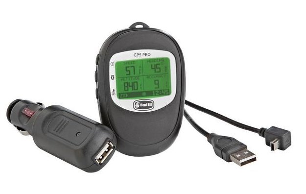
12 inch I pad Pro with Bad Elf gps. On a winding intercoastal route my Furuno 10.5 plotter will cross land where the Navonics stays true. $65 to update my C map a year verses $29 for last Navonics. No problem with visibility under my hardtop.
 
yes, our Raymarine used to show us aground near the Rockpile in SC while the Garmin charts showed us in the channel. This doesn't have as much to do with GPS, I think, than with the chart itself.

If you have Garmin Wifi, you can probably use the network GPS for your iPad that lacks the telephone capability. At least that works on my boat.
 
Even year to year and where the charts are from can make a difference.

My 2012 Raymarine e7 with lighthouse raster charts has been dead on in the ICW from NJ to Ft Pierce, Fl. Also the raster from NOAA and my OpenCPN.

Now I have had all of them be off in some creeks or places where routine navigation and surveys are few and far between or non existent since George Washington,
 
On a winding intercoastal route my Furuno 10.5 plotter will cross land where the Navonics stays true.


FWIW, I'd expect that to more likely be a chart problem, maybe, versus a GPS problem.

Still... could be GPS, but... when was the last time you updated the charts in the Furuno?

Another way to check would be to compare the actual GPS-reported coordinates on the two systems... when one chart shows you on land and the other says you're floating. If the coordinates are virtually the same, it's likely a chart issue. If the coordinates are different, well then maybe that one GPS (or the other) has gone wacko. :)

-Chris
 
A buddy has navigated all over the Caribbean with nothing but an Iphone. No problems.

I tried using an Ipad once on an offshore trip. One of my other Apple nut buddies said it was the most awesome thing on the planet (Apple people can be that way). I found it worked ok but rather clunky to use as a nav tool. I turned it off and went back to Coastal Explorer on a laptop.
 
Out of curiosity, honestly, how current are the charts on your iPad (when were they updated) and what is the edition date of the paper charts you have onboard?

That is a good point. Out of date charts, wheather paper or electronic are worse than useless. I use iNavX on my iPad, partly because NOAA charts are free, which means that I can update at least twice a year. Updates on my chartplotter are expensive.
 
I did two bare boat charters of a week each and used an iPad exclusively. Not ideal but it worked fine. The screen is difficult to read in the sun. Try it for a season and see if it works for you.
 
"IMO no boat in the ICW should be without a depth sounder."

Agreed , The first and BEST sounder is a marked pole that is strong enough to use to push off , and long enough to use from deck level.

It should also be light enough to use in the dink, to find the deep water.

This will help in laying out an anchor to kedge off.

Bamboo is usually first choice .

If an electric sounder is desired it should be the chart printing style so you can do contour nav. when the GPS is dead.
 
Sounder for Navionics/iPad

I use Navionics on my Ipad as my main route planning and nav system. Works fine and MUCH cheaper than buying a similar size screen chartplotter. Also much more user friendly. I think it costs me about $30/year to get all the updates I need. I also have Navimatics which I use almost exclusively for its integration with Active Captain.

I also recently bought for about $150 a SonarPhone. Depth sounder transducer can be mounted inside my fiberglass boat, and it wirelessly connects to the Ipad. Better yet, they say (I haven't actually installed it yet). that it integrates with Navionics and can display the depth in a window on the Navionics display. Hopefully the wireless signal will reach both helm stations....we'll see. But it sounds great.

Best,
Oldersalt
 
Touch screen computer monitor

So going beyond using an iPad or a laptop, has anyone just mounted a simple touchscreen LCD computer monitor on their bridge (with the computer hidden away)? A typical 22"+ unit can be bought for about $300.
 
I'm currently running an iPad alone for navigation. I use Navionics, and have the Skipper app (basic GPS on downloaded charts) on my iPhone for backup. For inland/coastal cruising, I'm having trouble picturing why I would need anything else (like chart plotter, Garmin GPS, etc). Thoughts on why that might not be the case?

I and millions of others navigated well before electronic charts and GPS so as long as you have a compass(adjusted) a good set of binoculars a DF and paper charts you are good to go.
 
How to clear your iPad's RAM :
You’ll occasionally need to clear your iPad's RAM. Clearing your iPad's RAM (I do once a week) can make a big difference in performance:
- Unlock your iPad,
- While you are on the home screen, hold the Sleep/Wake button until you see “slide to power off” message.
- Then release the Sleep/Wake button, press & hold “Home” button until the "slide to power off" dialog disappears AND you see your home application screen.

How to Hard Reboot your iPad : (I do twice a month)
- Unlock your iPad,
- Hold both the Sleep/Wake button and the home button - hold both buttons at same time - until the screen goes black AND you see Apple logo.

How to close background apps running in multi tasking mode : (I do everyday)
- Unlock your iPad,
- Double press the home button, then swipe up on window(s) you want it to close.
 
Last edited:
My iPad will only show a position within 65 meters when I'm out of cell phone range. Any ideas on how to fix? I've tried a complete reset but still have the problem
 
Two iPads. One for Navionics (new 12.9") and the other for Furuno wireless radar (old 9" one). Raymarine wireless depth sounder. Rarely at the lower helm, but all I need to do is take them below and viola - same electronics at the lower helm. Inexpensive, easy to update, and low boat buck investment.
 
@meridian: You definitely don't need cell coverage for the GPS in your iPad to work. Cellular can just help you get a fix *faster* when you're first starting it up. GPS signals can be obstructed by tall buildings and other dense objects between you and the sky, but the GPS receiver on the iPad is pretty good and should be as precise as any other handheld.
 
GPS via Bad Elf GPS receiver. Bluetooth to iPad. Works anywhere.
 
My iPad will only show a position within 65 meters when I'm out of cell phone range. Any ideas on how to fix? I've tried a complete reset but still have the problem

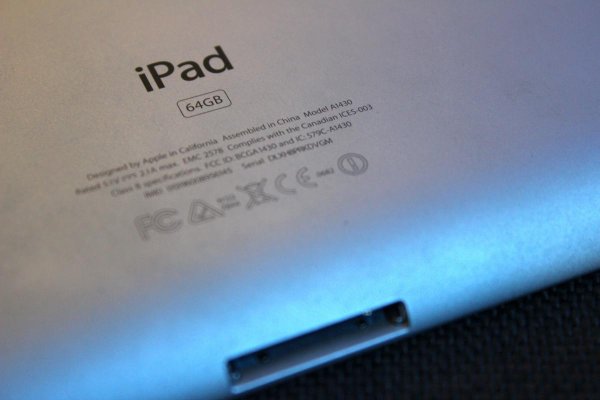
What model is your iPad ?
You can find the model # on the back of your iPad. It starts with the letter A followed by four digits.
 

Attachments

  • IMG_2329.jpg
    IMG_2329.jpg
    59.1 KB · Views: 68
Another thing: Try using a touch screen while in rough seas. Not fun.
 
My iPad will only show a position within 65 meters when I'm out of cell phone range. Any ideas on how to fix? I've tried a complete reset but still have the problem

This might sound a bit obvious, but are you sure your iPad has the GPS built in..? It's possible to get fixes via the mobile phone triangulation via the sim card, but the GPS should be superior, and not need to do that. Not all iPads came with GPS - just sayin'

Great tips there Pilou. Yes, hard reboot regularly very important for good operation. Often these devices are left too long in sleep or standby mode. Then strange things start happening...:nonono:
 
Another thing: Try using a touch screen while in rough seas. Not fun.
Actually, I disagree with that implication.

Two years ago, I took 2 Garmin "user experience" engineers out cruising with us for a couple of days. They wanted to test a next generation UI in different conditions. On a nice windy day, I took them out the Panama City inlet in wind against current conditions. The Gulf was giving 3-5 foot waves and we had 8 foot, choppy waves in the inlet. Perfect conditions for testing.

We lasted about 20 minutes - I set the bow directly into the waves to give maximum movement while still being safe. And through all of this, we tried different user interfaces to see how they'd perform.

Everyone ended up agreeing that touch screen controls were just as easy, if not easier, than hard buttons. The thing about hard buttons is that they are fixed. A soft touch screen provides the ability to have larger buttons if needed - something you'll start seeing as touch screens take over marine navigation. The key with touchscreen controls in rough weather was having the controls near the edge of the screen too - they are much easier to tap that way.

There are many chartplotters today that only have an On/Off button. I think that's a trend that will continue as more real testing like this is done.
 
I also recently bought for about $150 a SonarPhone. Depth sounder transducer can be mounted inside my fiberglass boat, and it wirelessly connects to the Ipad. Better yet, they say (I haven't actually installed it yet). that it integrates with Navionics and can display the depth in a window on the Navionics display. Hopefully the wireless signal will reach both helm stations....we'll see. But it sounds great.

Best,
Oldersalt

As a fellow Navionics user and angler, I've been interested in this SonarPhone since it was announced. I hope you find the time to post a followup on your experience with this unit once it's been installed and operated for a period.
 
Well.....it is about motion....so both opinions fit my experience.

My 40 Albin is no challenge for using touch screens.

20 plus knot boats and it is a different story.

If you have to hold on in your seat, touch screens can be tricky....even then dedicated button controls can be difficult but I have found better. Maybe some with Jeff's point about being big and near the edge so you can steady your hand.

The best in bad conditions I have used is remote control with buttons.....haven't tried a remote touch screen.
 
Last edited:
This might sound a bit obvious, but are you sure your iPad has the GPS built in..? It's possible to get fixes via the mobile phone triangulation via the sim card, but the GPS should be superior, and not need to do that. Not all iPads came with GPS - just sayin'

Neither of my iPad units have built in GPS. I purchased them this way on purpose and I use my phone as a WiFi hotspot.

Saying this, I purchased an inexpensive GPS received that connects via BlueTooth to my iPad using less iPad resources like battery time. Internal GPS running on a phone or iPad tends to reduce loiter time and having offsite GPS increases my time of use before recharge.

One iPad I use for Navionics and the other one for radar via WiFi. My WiFi radar is very accurate and easy to use. The accuracy of GPS for location services in pitch black night has assisted me in steering through unlit markers and I do trust it. At night, the Admiral is also on bridge to help me see anything that technology or I cannot spot.

mike
 
Another thing: Try using a touch screen while in rough seas. Not fun.


Rough seas? What are those? We stay at the dock in those. Might spill our beer or something.
 
I have an old radar along with a 15 + years old Garmin and my 9.7" Ipad Pro. Others mentioned that the Ipad was compromised in bright sunlight even under a hard top. Mine does not have these deficiencies, could it be the model of Ipad used?

Anyway, my Ipad beats the old Garmin with a larger screen. My days of spending big bucks for electronics are history. And sure, I forgot to mention I do have one of the new Standard Horizon dash panel mounted transceiver, a depth finder and several older backup transceivers. No need for fish finders here.

Today's newer technology will have a big impact on future marine electronics. Look at what newer solid state radars are selling for compared to what older maggies sold for. Personally, I strongly believe the future for magnetron radars is limited. I will not be surprised if the only place maggies will be found will be in microwave ovens, both consumer and industrial styles.

One other comment about magnetrons. Raytheon advanced the British magnetron's design during WWII so that it could be easily manufactured. This development was agreed to between our two nations as a part of the Lend/Lease program.

Raytheon was a world leader in high power microwave devices. Well, no more! They sold their Power Tube product line some 20+ years ago.
 
Last edited:
Like many, I have both. I find myself using the MFD's en route with occasional reference to tablet to see if chart is different. Backlit displays make a world of difference in bright sunshine. I have recently been turned on to garmin's tech to mirror the MFD on a tablet aka "Helm App".

Caveat: Still learning :)
 
So going beyond using an iPad or a laptop, has anyone just mounted a simple touchscreen LCD computer monitor on their bridge (with the computer hidden away)? A typical 22"+ unit can be bought for about $300.

Definitely. Mine are not touch because I prefer a keyboard and mouse, but no reason they can't be touch, and I know many people who have touch.

You still have the same considerations and compromises. Brightness and visibility in bright conditions, dimming and visibility in dark conditions, how to power it, and how to mount it securely. Also weather resistance if that's a concern.

Regarding weather resistance, it's not just about being out in the rain, or getting splashed by a wave. If you are out handling lines, then come in and start operating your nav equipment, whatever kind it is, you have just exposed it to salt water. I try to rinse my hands with fresh water before using any of the controls.
 
Neither of my iPad units have built in GPS. I purchased them this way on purpose and I use my phone as a WiFi hotspot.

Saying this, I purchased an inexpensive GPS received that connects via BlueTooth to my iPad using less iPad resources like battery time. Internal GPS running on a phone or iPad tends to reduce loiter time and having offsite GPS increases my time of use before recharge.

One iPad I use for Navionics and the other one for radar via WiFi. My WiFi radar is very accurate and easy to use. The accuracy of GPS for location services in pitch black night has assisted me in steering through unlit markers and I do trust it. At night, the Admiral is also on bridge to help me see anything that technology or I cannot spot.

mike


Mike, I use the Bad Elf gps puck. I am interested in your Bluetooth gps however. What unit do you use?
 

Attachments

  • BAD ELF.jpg
    BAD ELF.jpg
    23.6 KB · Views: 57

Latest posts

Back
Top Bottom