how to update a pair of garmin 8612s

The friendliest place on the web for anyone who enjoys boating.
If you have answers, please help by responding to the unanswered posts.

magna 6882

Guru
Joined
Apr 20, 2020
Messages
694
Location
USA
Vessel Name
Intrepid
Vessel Make
North Pacific/ NP-45 Hull 10
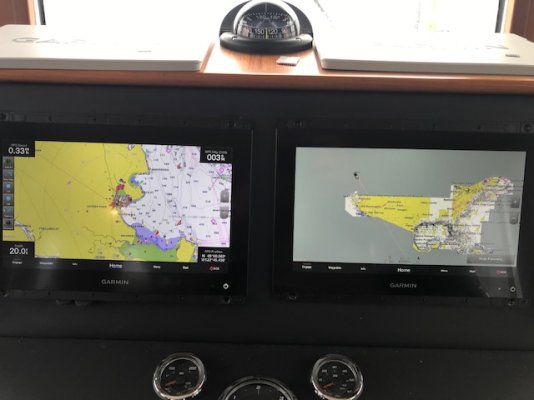
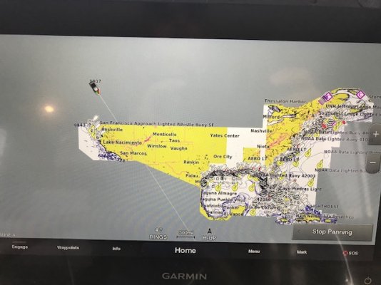
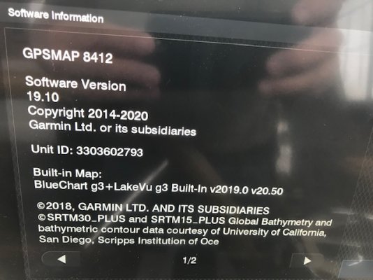
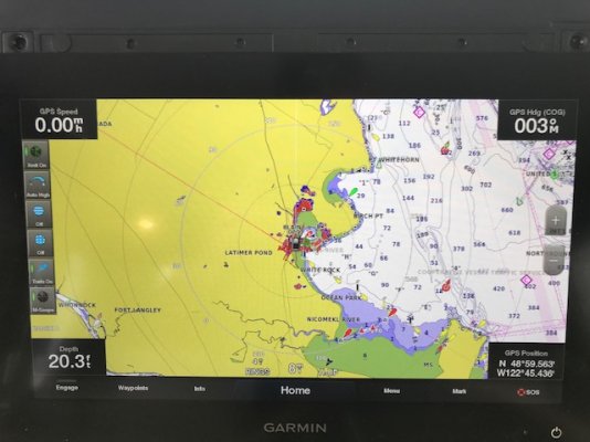
I read from the manual that i needed to update the 8612 to use active captain and use the sd card for the update. I loaded an sd card card then went to the boat. I removed the units and they both had 8g cards in them. I had a 32g so i pulled an 8 and put in my 32.The unit indicated it saw the update and would i like to proceed.I said yes and it looked like it would be a while so went for lunch. Came back and the unit i updated would not show charts. I assumed the update did both units at the same time. Now i am wondering if i messed up and need to do each unit. I am confused by having two identical units networked. How should i be treating these? Active captain come up on my phone but how do i know which one i am looking at. I am confused on how to proceed.
 
If you don't get an answer here go to The Hull Truth into the electronics section of the forum, you will get an answer there. I seem to recall a few quarries there similiar to your concern.
 
Have you tried Garmin technical support?
 
Hopefully they can help you. I know Raymarine support is very good. But I haven’t tried Garmin.
 
I don’t have Garmin but when I updated firmware for my two Simrads, I had to do each one. While they are networked, the data they exchange doesn't include the chart plotter software itself.

Mine have built in charts but I also have Navionics charts on micro SD cards. I have a menu choice of which charts I want to view. Is it possible you have charts on the 8GB cards you removed? Did you put them back? Also and obviously, if the chart card is in one plotter, it has to be turned on for the other plotter to access it. Just a couple thoughts.
 
I don't know if it's a factor here or not, but some embedded devices have limits on how large a capacity card they'll support using. Some were limited to 8gb, max and would behave poorly if a larger card was tried. You could sometimes get around this by using a PC to re-partition the card to have only one partition on it, of a reduced size.

I keep several 1,4 and 8gb cards around just for the purposes of updating/saving from old hardware.
 
Garmin's don't like those big SD cards. Should be no bigger than a 16GB. You can also update from your phone using the active captain app and wifi.
 
I worked on the boat today and still have a problem. Garmin called twice and they havnt seen this problem. The screen on the left is the 8612 and the 2 others are 8412. the 8612 contains the charts and shares them on the network. When we boot up the left units comes up fine and the right unit shows north America for 5 seconds then it show our boat in a gray area and if we blow up the chart we are seeing Florida which all contours.
 

Attachments

  • IMG_5570.jpg
    IMG_5570.jpg
    60.2 KB · Views: 18
  • IMG_5571.jpg
    IMG_5571.jpg
    78.8 KB · Views: 16
  • IMG_5573.jpg
    IMG_5573.jpg
    83.3 KB · Views: 17
  • IMG_5572.jpg
    IMG_5572.jpg
    78.8 KB · Views: 18
Where i am at now is the manufacture of the boat purchased another loaded maps package and installed it in the 8412. Now we see the chart and they think its fixed. I am going up tomorrow to look. I am wondering if there are charts loaded on both units and one sets a route will it show up on the other unit.
I am disappointed in the help i am getting from garmin. This is brand new equipment. Also not sure if we have to purchase another card for the FB.
Were just punting due to no help from garmin.
 
Back
Top Bottom