How do you use your iPad/Android for navigation?

The friendliest place on the web for anyone who enjoys boating.
If you have answers, please help by responding to the unanswered posts.
I use my i-pad to surf ahead chart wise just for fun or to find the days anchorage. My navagation habbits are rather casual so often I find the evenings anchorage on the i-pad. I plug it in to a cigarette lighter outlet to maintain the charge and stand it up between the Chart Plotter and the radar indicator when I'm not using the pad. The chart plotter always stays on the water just ahead of the boat and I surf about on the pad. The roaming and zooming about is far better on the pad. And most importantly I always see the rocks, shallows and other dangers just ahead.
I'm posting now on my new (yesterday) i-pad Pro at Starbucks. The 12-13" size w/o cellular or external keyboard. It's quite heavy but I am using a cover that alows quite a few different screen angle settings. It's more stable and I don't need to hold it up .. taxing some mussels in my arm. Much better than my old i
-pad air. Especially the pictures. So vivid and sharp. Very impressed.
Scrolling however seems as awkward as the old i-pad. My i-Mac at home is perfect in that regard.
Now I need to see if there's up grades for the Navamatics.
 
My Samsung Note 8 serves as:

1. Primary boat wifi hotspot while underway and at anchor.

2. At lower helm on ram mount for Navionics. Love the auto-routing and high resolution, crowd-sourced sonar charts. Supplements Garmin chartplotter and OpenCPN on nav laptop.

3. Since I have no real AIS, I use the pseudo-AIS on marinetraffic.com and boat beacon to provide a much-less-than-up-to-the-minute traffic display.

4. I enjoy audible books underway and listed through the tablet and stereo.

5. With Amazon Echo Dot onboard, the tablet serves as my wifi link underway for Dot and the Alexa app augments the verbal interface.

6. While I usually use my non-nav laptop for web use, including news and movies, sometimes I prefer the smaller footprint of the tablet to watch TV or movies. Both the laptop and tablet connect audio via bluetooth to the stereo.

7. The tablet or phone serves as a marina contact reference when approaching for dockage or fuel. I like to call ahead for fuel to advise them of my planned arrival and just in case diesel's not available when I arrive.

8. My tablet also serves as car navigation to and from the marina.
 
It's even easier than that with Coastal Explorer since they support the ActiveCaptain Route Storage & Sharing API. Within CE, routes put into the ActiveCaptain list are automatically synchronized with our server every time ActiveCaptain is updated. It only moves route data if there has been a change. It also downloads all changed routes back to the PC.

So you don't need to export routes and import than through DropBox. Just save them to the ActiveCaptain list within Coastal Explorer. They end up getting backed up on our server too and can also be viewed on the ActiveCaptain website (allowing you to share it with others). And since other apps use the RSS API as well, you could easily move the routes to other apps that don't support import, GPX, and file storage (like Aqua Map for Android or iOS).

I created the API and provided it without license to promote the automatic sharing of routes. Export/move files/import is so error prone and can't always be done. This mechanism works between various apps and is free for the developer and user. If you're using other products that don't support it, bother the developers to add it. I dream of a world where all my routes are easily available on all the apps and products I've purchase (even chartplotters).


I guess I didn't explain it very well. Instead of CE accessing and saving its files on the computer hard drives of each machine, I changed the file location to Dropbox and that one file is used by both computers. Both computers read and write to the same file. It can't really get much easier than that.
 
I guess I didn't explain it very well. Instead of CE accessing and saving its files on the computer hard drives of each machine, I changed the file location to Dropbox and that one file is used by both computers. Both computers read and write to the same file. It can't really get much easier than that.

Someday you'll want the routes on you iPad apps too (like this thread is about) and you'll find that DropBox won't help.

For Coastal Explorer alone, your solution is pretty good though.
 
I guess I didn't explain it very well. Instead of CE accessing and saving its files on the computer hard drives of each machine, I changed the file location to Dropbox and that one file is used by both computers. Both computers read and write to the same file. It can't really get much easier than that.

That is what I assumed from your description. I do that now with a number of data files that get updated a lot, and I did that with my email for years. Works great and is dead simple.
 
I got on the Navionics website. I cant fine any information on pricing.. Can someone help me out?
 
Not everyone worries about this, but I have stumbled across cruisers needing help due to a lightning hit. "all" the electronics went out. The tablet/iPad is a great backup, since it has total electrical isolation (if it's not charging). That, a handheld VHF, and non-electronic diesels will get you at least moving and navigating, if the near-worst happens.
 
Not everyone worries about this, but I have stumbled across cruisers needing help due to a lightning hit. "all" the electronics went out. The tablet/iPad is a great backup, since it has total electrical isolation (if it's not charging). That, a handheld VHF, and non-electronic diesels will get you at least moving and navigating, if the near-worst happens.

Having been hit while underway in a fully electronic diesel (we hold the record for the first Cummins QSB 5.9 to be hit underway) I can attest that there is no way to restart and run the computer controlled engine. But a hand held VHF survived and was able to communicate with the USCG 40 miles away. Our tablets, and phones all survived (we had the ability to call tow boat US by phone.), and we had the ability to watch on an electronic chart as Tow Boat US endeavoured to tow us over a 3' shoal. We draw 4.5. As an aside, we thought we lost our nav computer, however it turned out that only the power supply was knocked out the computer was fine. Every lightning strike is different, but our experience reinforces the assertion that electronics not connected to the ships power grid do seem to have a better chance of survival.
 
I usually have 2 iPads running in independently but in parallel with my chartplotter. WiFi connection is not necessary as all the content is device resident. Navionics has excellent charts and is the easiest of all systems to update. Their charts are consistently more up to date than any other system. Since we primarily operate from the pilot house and only use the bridge in nice weather, we have no concerns about water resistance. The auto route function is very handy for mid day what/if planning. I don't use it for my primary routing but as an auxiliaryplanning tool it is fantastic.

I pretty much do the same. Though now, while I have Navionics on my cell, I do not run it.

But I always run Navionics on my 12" Samsung tablet. My primary Chart is C-Map on Coastal Explorer.

I was told by Swedish sailors that Navionics is the best and most accurate Europe HD. I never saw a rock/hazard that was not marked on chart, even the two rock I hit where accurately depicted.

Crossing the Atlantic, it ran, but I never looked at it.

However, in any kind of coastal stuff, I always have it running because every once in a while I encounter a situation that is not clear to me. It's not a C-Map problem, but simply what I am seeing and what I expect to see. Therefore the Navionics, different colors and representation has been invaluable, as all of a sudden I need a third opinion.

So while it is not important 99% OF THE TIME, 01% it's a MUST have for me.
 
I use it as an internet device and also a backup to the main chartplotter. I do some light planning on it and also "look ahead" while underway, as someone mentioned. It Have Garmin Blue Charts on it as well as iSailor and other related apps(ie weather,etc.).

On a related note, the iPad has completely revolutionized my job(airline pilot). Everything we do is on the iPad now. All of the apps on it are developed by the company and fully integrated with each other. I check my piot mobile app...it has my schedule. I tap the upcoming flight. All of the dispatch flight planning "paperwork" comes up for me to review. I accept the release...hit the send button...and then import the paperwork to one of two apps....one being iBooks. I check the weather through a WSI app(vendor...same people as Wunderground I think) and then copy my route onto a Jepp charting app. It also helps when I brief the flight attendants to give them a picture of what I am talking about as it relates to weather. All of our manuals are on there as well and they update themselves automatically. All company related bulletins...EVERYTHING is on there. The only downside of it all is that it has made it so easy to push information to our iPad that the company pushes a HUGE amount of informations so it is sometimes hard to keep up with it all. The piloting profession has gone from undergrad level to PHD level simply because the company can expose us to so much information and it doesn't cost them a thing and does not require much resources other than the added "iPad team".

Anyway, sorry to go off on such a tangent. It truly is an amazing device. My main chart plotter is a Garmin 741....so not exactly the MFD grade of electronics. But it does all I need it to do. My current weekend cruising is done in familiar waters so I do not sweat the planning that much...I have been there before.

There is an interview of Steve Jobs on youtube(there are many). But if you search Steve Jobs interview 1995, you will find it. It is dry for sure. But he goes into some detail about the iPad even back then...14-15 years before it came out. It was his vision for us to be talking about this revolutionary device so many years later. He did not predict the future....he invented it.
 
He did not predict the future....he invented it.

"The best way to predict the future is to invent it."

Jobs is often given credit for that quote (although you only implied it). Actually, it was Alan Kay's quote, another interesting forefather of the technologies we take for granted today. Alan created Smalltalk and many of the ideas behind object oriented programming and is one of the people credited with coming up with window, mouse, and bitmap display user-interfaces. I met Alan about 3 careers ago when I was deeply involved with Smalltalk at Tektronix.

As a further aside, Apple is often said to have stolen Alan's / Xerox Parc's bitmap ideas and user-interfaces. Actually, 4 companies were given open licenses to it as part of experimenting and enhancing the new, wild ideas - Apple, Digital Equipment Corporation, Hewlett Packard, and Tektronix. That's what got me involved with the whole thing. Apple never stole anything and were instead the only company to really capitalize on the ideas. Tek created the 4404 which was a wonderful computer for the day - there's a nice YouTube demo of what it looked like in 1984 when I has involved with it:
https://youtu.be/8yxCJfayW-8
 
I have iNavx on my iPad Pro 9.7". 5 years ago, I bought an iPad II because of iNavx, and it's capabilities. I have Navionics charts as well as the complete suite of CHS charts for the WCBC. I use them primarily for planning now, but when we were doing bare boat charters, it was our primary nav tool. We have the same CHS raster charts on the coastal explorer.

I still use the iPad II on the skiff but it is difficult in sunny conditions.
 
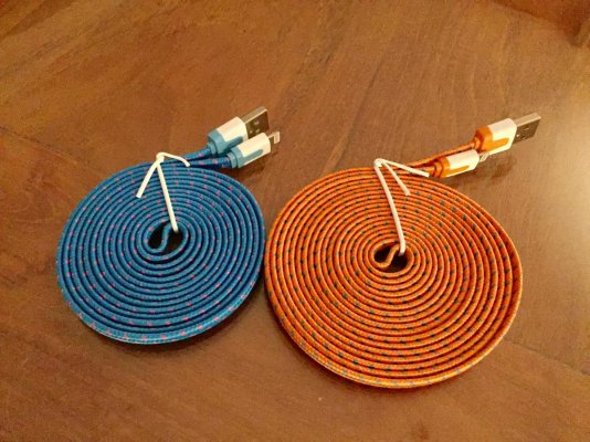
Very handy & useful aboard is long charging cables for iPad / iPhone.

Orange = 9'
Blue = 6'
 

Attachments

  • IMG_1462.jpg
    IMG_1462.jpg
    194.4 KB · Views: 61
Last edited:
Hi,
Do you mean the SP200 T Box ?

I installed the T box and use it with Navionics. Very easy to use and accurate(we physically measured and compared to the electronic measurement).
When I first purchased the boat, I crossed Lake Michigan from Chicago to St. Joeseph, MI (about 60 miles)in fog with a 100 foot visual and it took me dead center to the pier head. I am renovating to do the loop in about 3 years and will wait until the last minute for the electronics. Navionics will do very well until then. Interested to see what the future brings for pads.
 
Hi,
Do you mean the SP200 T Box ?


Pilou,
Yes, that is what I bought. Glad to hear it works well. Will install in the next month or so, after my bad back allows me into the engine room again!
Oldersalt
 
I installed the T box and use it with Navionics. Very easy to use and accurate(we physically measured and compared to the electronic measurement).
When I first purchased the boat, I crossed Lake Michigan from Chicago to St. Joeseph, MI (about 60 miles)in fog with a 100 foot visual and it took me dead center to the pier head. I am renovating to do the loop in about 3 years and will wait until the last minute for the electronics. Navionics will do very well until then. Interested to see what the future brings for pads.

I hope you had radar and knew how to use it in 60 miles of near zero-zero. What was your speed?
 
I got on the Navionics website. I cant fine any information on pricing.. Can someone help me out?

Dear Meridian,

The Navionics basic app is free. Just download it. Via your Ipad, go to the Navionics web site and look for their charts for sale. IIRC, the entire USA/Canada chart is about $50 and I think that includes a year's worth of free updates. At first is does not look very detailed, but then you will figure out how to use the "download" function. You select the detail area you want (it can be pretty big), and it will download the detail chart. So the whole chart is on your iPad and you don't need a cell connection, only GPS. (On my iPad, I had to buy the cellular-capable version, because that's the model that includes GPS. But I never enabled cellular functionality (I use my phone for that) and it works great.

They offer a "sonar chart" upgrade for more money, IIRC, but in my opinion that is most useful for inland lakes and/or fishermen.

The basic $50 chart includes tides, currents, (including a date look-ahead function) and can be used to get weather information as well. Plus, of course, very user-friendly routing and route tracking.

I also got the free Navimatics app and paid for the US chart too, mostly because it is directly tied into Active Captain (which you need to register separately for to use this). Haven't actually tried the charting/planning function on Navimatics because I like the Navionics so much.

BTW, I have no commercial connection to Navionics, I just really like the product!

Happy boating!
Oldersalt
 
I installed the T box and use it with Navionics. Very easy to use and accurate(we physically measured and compared to the electronic measurement).
When I first purchased the boat, I crossed Lake Michigan from Chicago to St. Joeseph, MI (about 60 miles)in fog with a 100 foot visual and it took me dead center to the pier head. I am renovating to do the loop in about 3 years and will wait until the last minute for the electronics. Navionics will do very well until then. Interested to see what the future brings for pads.

Thank you for sharing this.
 
Pilou,
Yes, that is what I bought. Glad to hear it works well. Will install in the next month or so, after my bad back allows me into the engine room again!
Oldersalt

Thanks Oldersalt, I am interested with it as a backup of the two depth / fishfinders aboard & as a versatile device with easy access to informations not limited to screen size. The Navionics chart integration looks really nice.

A review on Amazon.com could help :
'One thing that you should be aware of is that even though you can change the sonar phones network Name and give it a custom name it is not advisable when you want to use it with the Boating app. It is better to keep the default network name. I had done this and the boating app was not connecting with the data stream of the sonar phone anymore.'

I am wondering if its own WiFi hotspot could share the signal up to fly bridge.
 
I hope you had radar and knew how to use it in 60 miles of near zero-zero. What was your speed?

LOL no radar and my max speed is 12. We were cruising at a blinding 7-8 and I had one on the bow and several friends checking the AIS transponders. None in the area. It was late in the year and I had to get it back for the winter or I would have waited.

Definitely an interesting crossing.
 
Back
Top Bottom