Garmin 7600-8600 compatibility

The friendliest place on the web for anyone who enjoys boating.
If you have answers, please help by responding to the unanswered posts.

jimdavi

Senior Member
Joined
Aug 18, 2014
Messages
466
Location
USA
Vessel Name
Couple’s Retreat
Vessel Make
2019 North Pacific 45
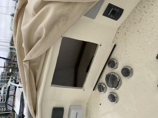
Nice surprise this am, while cleaning flybridge, ( after 3.5 month layup getting fins installed) and updating software. Assume was stolen at boatyard, and happy to have a $250 electronics deductible.

Does anyone know if you can plug in an 8412 into a 7612 system? 8600 would be slave unit without sonar. 7412 doesn’t seem to be available. I have in the pilot house a 7612-XSV and a 7412.

Hoping I can partially upgrade chartplotters. Garmin support wasn’t available.
 

Attachments

  • 49412FDF-D322-4ED3-9E8C-8DB43FB6F853.jpg
    49412FDF-D322-4ED3-9E8C-8DB43FB6F853.jpg
    121.3 KB · Views: 24
By "plug in" I assume that you mean to the NMEA 2k bus and not to a port on the back of the 7612...


Should work fine but you may get annoying "incompatible map update" messages. We had a 7612csv with depth sounder in the PH and then added a 1243 on the FB. Both see each other, share routes / waypoints via Active Capn just fine.

Kinda annoying that you have to remember which unit has the 'newest' charts IMHO...
 
Does anyone know if you can plug in an 8412 into a 7612 system? 8600 would be slave unit without sonar. 7412 doesn’t seem to be available. I have in the pilot house a 7612-XSV and a 7412.


I suspect it could be as simple as adding the 86xx to the NMEA2000 buss.


Should work fine but you may get annoying "incompatible map update" messages. We had a 7612csv with depth sounder in the PH and then added a 1243 on the FB. Both see each other, share routes / waypoints via Active Capn just fine.

Kinda annoying that you have to remember which unit has the 'newest' charts IMHO...

We have the 7612xsv, but chart updates are available... and from looking at the Garmin site, it looks like the 86xx models can (do?) use the same charts. Maybe 1243 uses same charts too?

FWIW, our 7612xsv chart update last June (2021) was from G2 to G3. Since then, Garmin has released a G3 update, but I haven't had time to mess with downloading that yet...

And of course they want 100 buck$ for it, compared to the free annual NOAA updates that we get for our Furuno system.

-Chris
 
And of course they want 100 buck$ for it, compared to the free annual NOAA updates that we get for our Furuno system.

Is this something new? Which line of Furuno plotters?

A few years ago I went looking for a system which would allow me to use the (free) NOAA charts I download for OpenCPN and other apps anyway. I didn't stumble on any Furuno systems which could do that back then, but I suppose I could have missed it.

This would be a game-changer for me. I like to keep my charts updated. Paying hundreds of dollars a year for the privilege of using the vendor's proprietary charts instead of the official NOAA charts doesn't appeal to me.

Not new. Available as early as the NAVnet 3D system starting circa 2006-ish (?) or so, at east. Maybe on earlier systems too. Carried through on their TZTouch, TZT2, and TZT3 systems.

CMAP charts (and for a long while, Navionics charts) have been available at extra cost. Dunno about how updates for those work.

Maybe you just didn't see Furuno's NOAA charts when you were looking.
They're different than what you would download directly from NOAA... in that MapMedia has done all the knitting for each chart set.

For further info: https://furunousa.com/en/products/gps_and_chart_plotters/browse?filter=Discontinued.eq.false&group={CFBDF652-0102-4A61-9835-CF99FD2D0A6F}&groupName=Charts%20for%20NavNet%203D,%20TZtouch,%20TZtouch2%20and%20TZtouch3

You'll see other chart types, too; sat photos, etc.

-Chris
 
Not new. Available as early as the NAVnet 3D system starting circa 2006-ish (?) or so, at east. Maybe on earlier systems too. Carried through on their TZTouch, TZT2, and TZT3 systems.

Thanks! They sure do hide it well. I can't find anything in the product specs which suggest free downloads are available. Even when I found the chart options, I had to go to the last page to find anything outside the $250-$500 range. Here's one example:
https://furunousa.com/en/products/mm3-usr-001

Funny how, in the manuals I searched through, the only hit on MapMedia was an offhand mention that they're "pre loaded." Nothing about updating them. Even on the download page I linked above, they include this:
Caution: Only replace this data if you have accidentally deleted it from your NavNet system, or if you need to update to the latest Edition.
Personally, I think everyone "needs" to update to the latest edition at some reasonable interval. Apparently Furuno doesn't agree. But at least I know it might be an option, and I know the right questions to ask. Thank you!
 
Talked with Garmin this am. They said you can mix and match 7000 and 8000 series units.
 

Latest posts

Back
Top Bottom