Navionics have been doing this for some time now, and the coverage is pretty good. Crowd sourced bathymetry is probably the future, now that the government is all but out of the business.Simrad's version of C-Map is building out a capability of collecting bathometry data collected and uploaded by users.
I don't know much about AquaMaps, but it appears to be just an app to display basic NOAA / govt maps. Heck, maybe that's what they all rely on, with just slicker interface / display options.
The govt is degrading GPS capabilities. Anyone have any insight on degrading charting?
Is the bathometry initiatives by Simrad and Furuno / TimeZero an effort to get ahead of govt chart degradation, and that dependency? Is Garmin really the one that needs to up their game too?
More questions than answers.
I think almost none of that is true. Aquamap is not just NOAA data any more than anyone other brand (though not particularly good in my opinion). The government isn't degrading GPS (that stopped back in the last century) and it would not matter if they did, as there are several functioning systems run by diverse governments.
And you know that how? Garmin has a long history of abandoning even their own products, let alone others. I would imagine they bought contractual obligations along with Navionics, once those are twilighted you are completely at their mercy.Lots of bad deduction here. Navionics will continue to be avaible to non-Garmin MFDs.
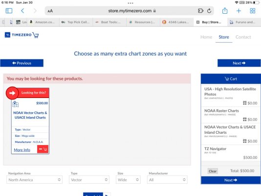
That seems like an outrageous price for what is otherwise free to download. It is not close to competitive for other companies doing the same thing (messaging formats to proprietary).And “NOAA Vector Charts & USACE Inland Charts” which are $500 but cover all of the areas in the continental US an east coaster is likely to travel in.
If anything this discussion would push me more towards generic hardware and open source software.
") ) Again, 3/24 and 3/25 is a key date.
) Again, 3/24 and 3/25 is a key date.