You are using an out of date browser. It may not display this or other websites correctly.
You should upgrade or use an alternative browser.
You should upgrade or use an alternative browser.
Fake AIS targets - WTF is going on here?
- Thread starter Simi 60
- Start date
The friendliest place on the web for anyone who enjoys boating.
If you have answers, please help by responding to the unanswered posts.
If you have answers, please help by responding to the unanswered posts.
Simi 60
Guru
- Joined
- Jul 1, 2016
- Messages
- 5,482
- Location
- Australia
- Vessel Make
- Milkraft 60 converted timber prawn trawler
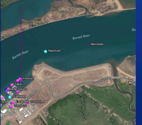
After a 32 day stint out at the reef we arrived in Bundy yesterday afternoon
On anchoring, one of the targets was showing on AIS behind us
Thing is, in real life , looking out the back, there is nothing there
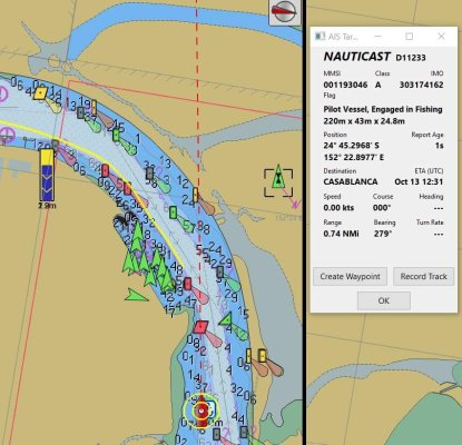
But on my chart plotter it to sees it there as a 200 metre long vessel destination, cassablanca.
To make things even more bizarre it moved down towards the trawlers in bottom left of pic but over land and then back to us again.
And, on marine traffic if you click on the target, it has a name change from Nauticast to Sea Melody.
On the way in to Bundy, on my chart plotter it was showing as Main Event - but, there is no vessel on marine traffic in Bundy called Main Event and there isn't one on the plotter now either.
Bottom pic a few hours later has it over land on the north side of river.
This morning back on land on South side.
It's doing my head in.
Attachments
Last edited:
SteveK
Guru
- Joined
- Jul 5, 2019
- Messages
- 5,077
- Location
- Gulf Isalnds BC canada
- Vessel Name
- Sea Sanctuary
- Vessel Make
- Bayliner 4588
Typical UFO flight pattern
twistedtree
Guru
I would guess a faulty GPS feeding the AIS. Or perhaps a faulty AIS device itself.
RT Firefly
Enigma
Greetings,
April fool's joke???
April fool's joke???
O C Diver
Guru
- Joined
- Dec 16, 2010
- Messages
- 12,878
- Location
- USA
- Vessel Name
- Slow Hand
- Vessel Make
- Cherubini Independence 45
Couple of possibilities:
First, the target position appearing on your or anyone else's chart plotter is a function of the AIS's GPS on the target. Simply, a target with a faulty GPS as part of its AIS can have the target appearing on your plotter, where it's not physically located. I use to use a tablet with a built in GPS for Aquamaps. The GPS went flacky and Aquamaps had me traveling through a golf course.
Secondly, if someone is pranking, the older AIS (like I had on my charter boat) were all user programmable. All the information (including vessel name) was entered by the user. Was common to see targets with no name, an MMSI number, and occasionally a made up name.
Then there are those who leave their AIS on while the boat is going down the road.....on a trailer behind a car.
Ted
Simi 60
Guru
- Joined
- Jul 1, 2016
- Messages
- 5,482
- Location
- Australia
- Vessel Make
- Milkraft 60 converted timber prawn trawler
Just poor GPS stability. Could be a partially obstructed GPS antenna blocking some of the satellites.
That might explain position changes
But not the name changes from Main Event to Nauticast to Sea Melody.
RT Firefly
Enigma
Greetings,
Mr. S. marinetraffic.com shows Nauticast exactly where your screenshot shows. On shore. Might it be a satellite problem/malfunction or some sort of jamming effort although I have no idea WHY anyone would jam signals. The world situation is chaotic but not THAT much. Would the Australian Coast Guard have any idea?
Edit: Nauticast is listed as being engaged in fishing and occupies the same space as MV Male Anch and Sea Melody (Pilot vessel-tug). VERY strange, indeed.
Last edited:
twistedtree
Guru
That might explain position changes
But not the name changes from Main Event to Nauticast to Sea Melody.
Does the name change when viewed from your chart plotter, or just on Marine Traffic? Marine Traffic is a bit of a hack job, so I would take anything that it shows with a grain of salt.
RT Firefly
Enigma
Greetings,
Mr. tt. Sorry that's all I have. Just trying to help.
Mr. tt. Sorry that's all I have. Just trying to help.
Simi 60
Guru
- Joined
- Jul 1, 2016
- Messages
- 5,482
- Location
- Australia
- Vessel Make
- Milkraft 60 converted timber prawn trawler
Does the name change when viewed from your chart plotter, or just on Marine Traffic? Marine Traffic is a bit of a hack job, so I would take anything that it shows with a grain of salt.
Did it on both
But on the plotter it was Main Event several miles out and now in close it's only Nauticast seen.
No Sea Melody or Main Event in the area.
- Joined
- Mar 17, 2012
- Messages
- 4,279
- Location
- Australia
- Vessel Name
- Insequent
- Vessel Make
- Ocean Alexander 50 Mk I
Multiple MMSI's? Possibly a VHF radio (handheld?) or EPIRB acquired from another boat being used without updating details with AMSA. Although not sure that an EPIRB's GPS etc would be ON unless it was activated.
Has to be a transmission from a portable AIS, whether a handheld radio or PLB or some such. Also from the name changes and such it is likely after a sale of the boat and before any registration changes. When the new owner figures out how to turn it off and gets the reg done all will return to normal.
North Baltic sea
Guru
Hi,
this can also be intentional harassment, from a state. Here in Finland, along our border in the east and in northern Norway, GPS signals have been disturbed for a long time, and airplanes have had to change their routes when the GPS interferes. This is known that the question is an intentional harassment.
Maybe someone was upset when the information about the new submarine acquisitions was published...
NBs
Similar threads
- Replies
- 45
- Views
- 5K


