Do heading sensors play well together?

The friendliest place on the web for anyone who enjoys boating.
If you have answers, please help by responding to the unanswered posts.

O C Diver

Guru
Joined
Dec 16, 2010
Messages
12,878
Location
USA
Vessel Name
Slow Hand
Vessel Make
Cherubini Independence 45
So I'm pondering replacing my autopilot. The old pilot that still works flawlessly is a Robertson Simrad AP 20, 21 (remote), FU35 (jog lever), and RFC35R (rate compass). It gets its steer information from the Garmin MFD over a NEMA 0183 network.

The Simrad I'm considering networks all it's pieces through the NEMA 2000 network.

My Garmin MFDs use a Garmin heading sensor for some functions including some aspects of the radar.

Currently, the AP20 system has a heading sensor that only talks to the autopilot black box.

So the questions are:

Do you use more than one heading sensor with a NMEA 2000 network?

If you use only one heading sensor (compass or GPS), what is the likelihood that Garmin and Simrad will both work off a 3rd party (other than the same manufacturer's) heading sensor?

Since the Simrad will accept NEMA 0183 comand from the Garmin MFDs, is there any reason to not set the autopilot up as it's own NEMA 2000 network, and import the data from the MFD on NEMA 0183?

Ted
 
Ted, I'm not 100% sure what you're trying to end up with. A maretron compass, for example, will transmit heading for your current pilot via 0183 @ 10Hz and simultaneously xmit it on the nmea2000 buss for your mfd's to see but again, I guess I need to more closely study your post to see what you're wanting to accomplish.
 
Ted,

The only thing I can offer is your new autopilot should be be able to select data sources when there is more than one source of the same data, GPS for example. Raymarine has data source selection in its menu, but most of time it doesn’t work if there is a Raymarine source of the same data.

Tom
 
Ted I have had a Simrad setup that had multiple heading sensors, multiple gps sources all on NMEA2k with no problems at all. On a NMEA2k bus each device has its own identity. The autopilot may chose what it considers the best one if you do an auto setup, but you can specify which device to use for each purpose.

Ken
 
What is the new autopilot you are looking at buying? What are you trying to accomplish? If its just you want a new heading sensor, then the ap20 and a j300x that has firmware later than V1R8 can accept heading data over NMEA 0183. So you could have a new heading sensor AND your rfc35 hooked up to the j300x and then have a backup heading sensor if one died.

I recently (month or so ago) added a simrad ap70mk2 with an ac70 as a primary controller and swapped my j300x,ap20,rfc system over to backup duty. I have a toggle switch at the helm which controls which AP drives the pumps. This gives me the ability to survive a lot of failures before I am without an autopilot.

My boat drove really poorly with the ap20/j300x. The new autopilot has been transformative. Its so much better its hard to believe.

As it sits now I have a furuno scx30 sat compass, two gp33 gps, and a fourth older gps sensor all riding on an N2k network. On the ap70 you can select primary sources for data, as well as specify backup devices.

A reason to not import all data from the MFD is that you then require the MFDs to be functioning for your autopilot to work. If you were feeding position and heading data direct to the autopilot, your MFD could die and you could still use auto mode to navigate home.

My system works and has been robust. However, I have been cautioned by many people, and by simrad technical support, that not all devices will play well together with the newer simrads and Nmea 2000. I cautiously add devices to the network.
 
Im trying to figure why would you would "fix" what ain't broken??..>>>Dan

Autopilot is 20 years old with 30,000+ miles and 5,000+ hours on it. I use it 99% of the time. I cruise about 6,000 miles per year. Really don't what to do an autopilot replacement in the middle of nowhere when it dies.

Some people do preventive maintenance; others loose their cruising season, fixing what's broken.

Ted
 
Ted, I'm not 100% sure what you're trying to end up with. A maretron compass, for example, will transmit heading for your current pilot via 0183 @ 10Hz and simultaneously xmit it on the nmea2000 buss for your mfd's to see but again, I guess I need to more closely study your post to see what you're wanting to accomplish.

Simply, I don't want to have issues with different manufacturers products not working with one heading sensor or 2 heading sensors causing a problem.

Ted
 
Ted,

The only thing I can offer is your new autopilot should be be able to select data sources when there is more than one source of the same data, GPS for example. Raymarine has data source selection in its menu, but most of time it doesn’t work if there is a Raymarine source of the same data.

Tom

Thanks.

Ted
 
Ted I have had a Simrad setup that had multiple heading sensors, multiple gps sources all on NMEA2k with no problems at all. On a NMEA2k bus each device has its own identity. The autopilot may chose what it considers the best one if you do an auto setup, but you can specify which device to use for each purpose.

Ken

Thanks, appreciate the information. Trying to figure out if my older Garmin displays and a new Simrad autopilot will use a 3rd party's GPS compass.

Ted
 
Last edited:
Ted
We had the same exact question on our vessel regarding multiple heading sensors. But, when considering two APs, radar, AIS and Marpa as well, the answers were less clear. The conundrum for us, yet to be resolved, is what single sensor will do it all? I'll stay tuned. :confused:
 
What is the new autopilot you are looking at buying? What are you trying to accomplish? If its just you want a new heading sensor, then the ap20 and a j300x that has firmware later than V1R8 can accept heading data over NMEA 0183. So you could have a new heading sensor AND your rfc35 hooked up to the j300x and then have a backup heading sensor if one died.

I recently (month or so ago) added a simrad ap70mk2 with an ac70 as a primary controller and swapped my j300x,ap20,rfc system over to backup duty. I have a toggle switch at the helm which controls which AP drives the pumps. This gives me the ability to survive a lot of failures before I am without an autopilot.

My boat drove really poorly with the ap20/j300x. The new autopilot has been transformative. Its so much better its hard to believe.

As it sits now I have a furuno scx30 sat compass, two gp33 gps, and a fourth older gps sensor all riding on an N2k network. On the ap70 you can select primary sources for data, as well as specify backup devices.

A reason to not import all data from the MFD is that you then require the MFDs to be functioning for your autopilot to work. If you were feeding position and heading data direct to the autopilot, your MFD could die and you could still use auto mode to navigate home.

My system works and has been robust. However, I have been cautioned by many people, and by simrad technical support, that not all devices will play well together with the newer simrads and Nmea 2000. I cautiously add devices to the network.

I'm considering a Simrad AP48 with a NAC 3 black box.

I've got my AP20 set up where it does a great job, it's just getting really old and I don't want to cruise without an autopilot.

I've had minor issues with somethings not being recognized by other things on the NEMA 2000 network. So I really only wanted the heading to waypoint information coming from my MFD or Coastal Explorer on my PC.

Ted
 
Ted
We had the same exact question on our vessel regarding multiple heading sensors. But, when considering two APs, radar, AIS and Marpa as well, the answers were less clear. The conundrum for us, yet to be resolved, is what single sensor will do it all? I'll stay tuned. :confused:

I'm hesitant to put all my eggs in one basket, so to speak. I would prefer to have the autopilot with its own heading sensor of the same manufacturer. Cruising without a rock solid autopilot is too much like work.

Ted
 
Not sure if this helps. I use a KVH compass as a heading sensor for my Garmin radar and plotters. Uses NMEA0183. They also have stand alone heading sensors. Was told that the compass and sensors will work with most any gear FWTW.
I still have a magnetic compass at the lower helm.
 
I think its definitely a good idea to have multiple input sources and not put all your eggs in one basket. With the newer cheaper simrad computers is that you only have one nmea0183 input. I don't think until you get to the AC80 do you get multiple nmea0183 inputs.

The issue with this is that if you are sending heading over nmea0183 to the AP computer via a dedicated compass, that means you cant send waypoint information over nmea0183 from your MFD or nav computer unless you run it through a multiplexer.

If you really want to enclave off the autopilot the way to do it might be to put in the newer simrad autopilot and computer with the nac3. Put in a simrad hs75 compass and connect the nac3 to the hs75 on its own nmea2000 network. That way your autopilot system is all simrad together. Then you could hook both your MFD and coastal explorer to the nac3 via nmea0183 to send waypoint nav data. I'd just put a toggle switch to swap between the sources. An added perk is that you could set your garmin MFD to also output heading data via NMEA0183. Then you'd have a backup heading source fed into your nac3 in case your nmea2000 bus shut down.

I'm considering a Simrad AP48 with a NAC 3 black box.

I've got my AP20 set up where it does a great job, it's just getting really old and I don't want to cruise without an autopilot.

I've had minor issues with somethings not being recognized by other things on the NEMA 2000 network. So I really only wanted the heading to waypoint information coming from my MFD or Coastal Explorer on my PC.

Ted
 
Most will do what you want, but if you want a LOT of flexibility for multiple output formats that will hook to most anything, you could buy a furuno sc70. I believe it has something like 9 nmea0183 outputs, a nmea200/canbus output, and several AD10 outputs(only matters if you've got older gear).

It allows for per channel keyword filtering and rate selection so you can send only what each device needs.

Only problem is its like 5k$. However, i helped retrofit one into a boat and its a really nice piece of equipment.


Ted
We had the same exact question on our vessel regarding multiple heading sensors. But, when considering two APs, radar, AIS and Marpa as well, the answers were less clear. The conundrum for us, yet to be resolved, is what single sensor will do it all? I'll stay tuned. :confused:
 
My boat came with a NMEA 0183 network. All the stuff that shared the output sentence was tied together on a terminal block. I think the only input was a Garmin GPS antenna.

Ted
 
0183 can have only one 'talker' on the circuit, thus nothing will "play together". On N2K when you have more than one device generating the same data they are distinguished by assigning each a different instance in the device configuration. In their configuration, devices that use this data will require you to select the instance to be used by that device. N2K data is standardized across all manufacturers. The products of different makers should all play together.

I'm not sure if your AP21 will accept heading over 0183. What it is getting from the MFD is navigation data - range and bearing to WP and cross track error. It's compass info comes in on the RobNet bus. An N2K pilot should accept heading from the N2K network and I expect most are using that as standard.
 
Heading sensor

It amazes me that people who spend 10's or 100's of thousand dollars on their boat balk at paying money in respect to the safety of that boat.

WHY would you even consider mixing & matching products?

Yes, the network will transmit the data but what and how fast will be the question and Garmin has no reason to meet with any other manufacture to make it work flawlessly. Remember, Garmin is a multi $B company and the largest in the marine field. How much of their R&D budget do you think is spent on 'shaking hands' with other manufacturers.

So, with that in mind, do you really want to risk a situation where speed or accuracy is of the essence?

Go all Garmin and don't run the risks that could crop up.

Thant's my 2 cents and I'm sticking to it.
 
Hear is what I can tell you! I bought my boat used with all Simrad STUFF. From MFDs, GPS sensor, a $800 Prediction 9 compass, a $250 GS25 heading & GPS sensor and Auto pilot. They all worked great!!

Now I take my laptop and install TZ and AIS on my boat. On the TZ software my heading kept swing about 15 deg back and forth. The AIS would show other boats on the display anywhere from 0 to 180 deg turned. I calibrated the compass and GS25 and it did not help.

I removed the GS25 and installed JUST a GPS sensor. Both heading sensor data were passing over the N2k network. But you could tell the AP and the MFD which sensor to use. But the laptop and AIS was more complicated to do so.

Just be carful and think it though.
 
Last edited:
It amazes me that people who spend 10's or 100's of thousand dollars on their boat balk at paying money in respect to the safety of that boat.

WHY would you even consider mixing & matching products?

Yes, the network will transmit the data but what and how fast will be the question and Garmin has no reason to meet with any other manufacture to make it work flawlessly. Remember, Garmin is a multi $B company and the largest in the marine field. How much of their R&D budget do you think is spent on 'shaking hands' with other manufacturers.

So, with that in mind, do you really want to risk a situation where speed or accuracy is of the essence?

Go all Garmin and don't run the risks that could crop up.

Thant's my 2 cents and I'm sticking to it.

Well since you asked, Garmin isn't a consideration as they only have very limited offerings when it comes to autopilots.

My boat has a jog lever. Garmin doesn't offer any.

I will be replacing my pump with another high volume one as I have a large cylinder to go with my large rudder. Garmin doesn't offer one.

I want the option to choose the features I want in my display and remotes. Garmin has a very limited selection.

In case you missed my original post. I've been running the original Simrad system for 6 years with navigation input from my Garmin MFDs. It works flawlessly. There's no reason any manufacturer's autopilot shouldn't work off the navigation data sent from my Garmin MFDs or the PC interface from my Coastal Explorer.

Ted
 
Heading sensors

Since I don't know your specific steering setup, I will have to think that you have a very unique boat.

Also, we may both require different things from our NAV products. I use the autopilot & a remote to lay in a course & drive our boat, you may not use an autopilot for that.

Garmin, here (https://www.garmin.com/en-US/c/marine/boat-autopilots/) has a broad range of autopilots and I'm surprised that there isn't 1 that meets your needs, BUT, if another manufacturer does have what you need, I might think that older technology can always be available.

Garmin, like other companies, Microsoft, said years ago, that there was no looking back. So, in my mind, finding the options that will meet your needs may be very easy with antiquated products and they are usually very inexpensive.

Me, I like the newest and the best, as I consider safety paramount on our boat, therefore I upgrade my NAV system regularly. I swapped out a 7612 for an 8616. I removed my 600 AIS and installed an 800. The reactor 40 autopilot on our boat hasn't changed much but the autopilot 'head' has been updated so I am in the process of swapping out our 20 for a 50.

I never said it wouldn't work I said that it might not respond as quickly or as well as it would in a total Garmin environment.

We all make decisions about product for our boat and some base that on cost. A few hundred or thousand dollars for safety is something I will spend to ensure the best and safest possible environment for crew & boat.

Be safe & healthy out there,

Charles


While I agree with the sentiment in you post, I think for many boats it is better accomplished via the path O C Diver outlined. I want best of breed for each component; AP, AIS, radars, chart plotter, Sat compass, fish finder, weather instrument, etc. In accomplishing that, it turns out I don't have a single piece of Garmin equipment on board. It's not that it's bad, it's just not the best at anything other than perhaps offering an all encompassing package.


To add to OC Divers list, they only offer a low end sat compass, and it's N2K only. The AP doesn't support external followup steering stations. I want to use official charts from NOAA, CHS, etc. Garmin doesn't offer that, only Garmin's "maps", which itself just says it's amateur. It's a chart, not a map. Maps are for cars. And the display you look at isn't a GPS, it's a chart plotter. Their use of the term "GPS" is again drawn from car use. It all just reeks of inexperienced weekend boaters, which is understandable because that's their target market. The AP is a completely proprietary setup as opposed to everyone else who uses standard interfaces between components. They don't offer any stand-alone radars - only radars that work with an MFD. And none of the radars support ARPA. And they don't offer any Class A AIS.


Now it doesn't mean they aren't good for a large part of the market, and they are. But it's not the whole market - not even close. And there are plenty of advantages to other equipment, and actually advantages to not getting locked into their single vendor system and sticking with industry standard interfaces.
 
0183 can have only one 'talker' on the circuit, thus nothing will "play together".

There is a good way around the limit of one talker. Noland Engineering males a NMEA 0183 multiplexer. Multiple talker sentences are received by the device, combined and sent back out on the network as a single talker signal with all valid NMEA 0183 sentences intact.

What each listener does with the message is dependent upon how the listener is designed and set up.

It can lead to a jittery display or behavior if the listener cannot prioritize input. Each individual talker will transmit slightly different data. So in that sense multiple heading sensors may not play well together.

There are probably other manufacturers of NMEA multiplexers. Noland is the one I'm familiar with. I find their gear to be reliable and robust.

I have also used simple A/B serial data switches to isolate one talker keeping the other in reserve.
 
I agree that NMEA 0183 is stone-aged technologically, but I have switched away from NMEA 2000 for primary navigation electronics and now build them entirely using 0183. And I now understand why NMEA 2000 is still not approved for IMO boats.


It takes more planning and care to set up 0183 communications among a number of devices, but it's operation is 100% deterministic. Once you wire it up and set up the sentences, it will work the same way, all day, every day from the moment you turn it on until the moment you turn it off. Gone are all the funky interactions between devices, and the weird behavior of one device when you do something with another device.


So primary compass, primary heading sensor, AIS, autopilot, radars, and chart plotter all exchange their data via 0183. It's 100% reliable. I only use N2K for things where it doesn't matter if something goes hicup, or goes off line, or if a data source mysteriously changes, or if the network needs to be power cycled to get things working again.


N2K is fine, actually quite good, for a smaller setup. I use it for chart plotter & AIS on my tender, and used it on a 28' Grady. But as an N2K system gets larger, the interactions that cause problems grow exponentially. Support for multiple/redundant devices is where things start to unravel pretty quickly. It can be made to work, but it's delicate.
 
I thought I was the only one that found NMEA 0183 to provide simple and solid data exchange between navigation units. Everything is connected via terminal blocks. The 2000 cables that came with the units are still in their packages.
 
Heading sensors

I think at this point it is better to say we disagree on most points and to offer some news, clarification on your statement.

Garmin charts, that you clearly misnamed as maps are Navionics charts. You know that company who supplies charts for around the world, that are top rated and used by other companies. I don't think anyone who has any knowledge of the marine industry, or the use of charts would say that Navionics is amateurish or a map. Maybe you need to do some more research before you make statements.

BTW, Garmin owns Navionics, so they probably use Navionics CHARTS in their products.

As to your comment, "The AP doesn't support external followup steering stations" I'm not really sure what you are saying but hopefully anyone who has used the Garmin AP as I have, to drive our boat from point A to point B knows how accurate the AP is. Some who don't, don't realize that there is a set up that is necessary and after that is done, the AP will keep you in the depth your boat needs while watching out for air draft at the same time. IF you mean that while using the AP you can't take over from the AP and hand steer you are completely wrong. Check Garmin and see what their shadow drive does when you take over the wheel.

0183 or 2000 as I said you can find older equipment that will meet your needs, 2000 is proven better, & faster so stick with your older tech that is the decision that every owner must make.

The only last thing that I will reiterate is that Garmin is the largest company in the marine NAV field. They didn't get to be the biggest & best because their equipment is 2nd rate or because they give away their R&D or testing. The money in R&D they spend is garnered from sales. They got to be the biggest & best because they make a great piece of equipment with the best support in the industry. Do you know that Garmin is also the best equipment you can buy for an airplane!

Look at any other brand, Ray maybe, that was just sold & bought again, and you should know that continuity is important.

The only reason I decided to have this 'discussion' with you was so that others would see that your approach is not necessarily the best approach. I would close by saying you should check things out before you make some of your statements. Road maps, really??!!

Good luck out there, try to stay safe.
 
Garmin charts, that you clearly misnamed as maps are Navionics charts. You know that company who supplies charts for around the world, that are top rated and used by other companies. I don't think anyone who has any knowledge of the marine industry, or the use of charts would say that Navionics is amateurish or a map. Maybe you need to do some more research before you make statements.

BTW, Garmin owns Navionics, so they probably use Navionics CHARTS in their products.

As to your comment, "The AP doesn't support external followup steering stations" I'm not really sure what you are saying but hopefully anyone who has used the Garmin AP as I have, to drive our boat from point A to point B knows how accurate the AP is. Some who don't, don't realize that there is a set up that is necessary and after that is done, the AP will keep you in the depth your boat needs while watching out for air draft at the same time. IF you mean that while using the AP you can't take over from the AP and hand steer you are completely wrong. Check Garmin and see what their shadow drive does when you take over the wheel.


The Navionics stuff is the case now (at least for newer Garmin MFDs). But that has not always been the case, as Garmin only purchased Navionics fairly recently. Historically, Garmin packaged their own charts.


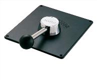
By followup steering stations, he's referring to a jog lever like in the picture below, where you can move the lever and have the autopilot pump drive the rudders to that position (and they'll stay there until you move the lever to a different position).

7171.tmb-.jpg
 
Nep
Your emotional support for Garmin while laudable possibly bears a step back. Carefully reading and thinking about TT's various posts over the years has proven quite helpful for many of us especially given his IT background and putting many $$ into the marine electronics improvement game.

A couple of metrics I use when listening to folks on TF is the experience factor such as how many miles traveled per year and where and hands on direct industry experience. TT has it in spades.
 
Back
Top Bottom