Auto routing

The friendliest place on the web for anyone who enjoys boating.
If you have answers, please help by responding to the unanswered posts.
Exactly!If thats what you prefer that is certainly your choice.
I dont get it right 100% of the time and always make it a habit to double check myself or any other route provided by others or any software. Maybe you are better than I and never make an error in waypoi to or routes.
Auto route has been a VERY useful tool for me in SOME situations.
I NEVER follow blindly and it is a backup for either a route I plotted or visual Nav with the auto route as a guide.
Too bad so many are so closed minded and willing to toss a potentially useful tool in SOME SITUATIONS.
As with many things trust but VERIFY!


Don,
I couldn't have said it better.
If one doesn't trust computer, they might be better off in another world. Virtually everything we do is computer related. Might as well, through out you chart plotter, dump the Ipad, dump your TV, engine controls in some cases, Generator, inverter, etc., etc.
Also, might as well cancel you bank account and put the money in your mattress, sell your car, dump your credit cards, drop your insurance, etc., etc.


I think you get the point.


However, nothing wrong with trust but verify.....
 
If thats what you prefer that is certainly your choice.

.

OpenCPN and my dedicated seiwa plotter simply do not have that facility
Safety feature I would guess

I dont get it right 100% of the time and always make it a habit to double check myself or any other route provided by others or any software. Maybe you are better than I and never make an error in waypoi to or routes

And I won't trust Navionics autorouting as it would have taken us into dangerous waters on more than one occasion if I had trusted it, something I will not do.
Just as well one of us knew how to plot a course.

With mouse driven opencpn it is far easier than the menu driven madness that most other plotters use.

As for never getting it wrong I am continually checking and adjusting if required while enroute.
Hard to get it wrong if doing that.
 
This is the first argument against it that has made any sense to me. That is "on my plotter, doing it is so easy that there's no advantage to auto route". If that was the case on my system, I may be inclined to agree.

But it's not. And on the vast majority of people's systems (which is one or maybe two plotters of various ages) it's a PITA to long press, or move a cursor and hit a button, and god forbid you need to move that waypoint. It just sucks.

The fact that a particular system is easy to use doesn't invalidate the technology. It just makes it less valuable on that particular system. But I'm happy that you have such an easy to use system - it sounds like a perfect fit.
BD
 
What an interesting thread. And we managed to stay away from politics!

With so many here favoring auto routine this morning I took another look at it. I asked Navionics to give me a route from San Diego harbor entrance to Bodega Bay entrance, a run I've made many times. Here's what I found.

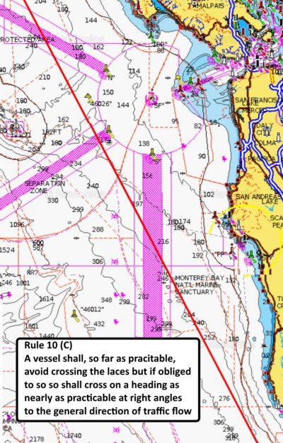
The first problem starts north of the Channel Islands crossing the VTS lanes improperly in violation of Colregs Rule 10(c).

Next the route passes for me uncomfortably close to the oil rigs off Pt Conception and Pt Arguello.

Continuing up the coast the route again violates Rule 10(c) in the San Fran VTS area, twice this time. The attached image shows Navionics routing through the San Fran VTS

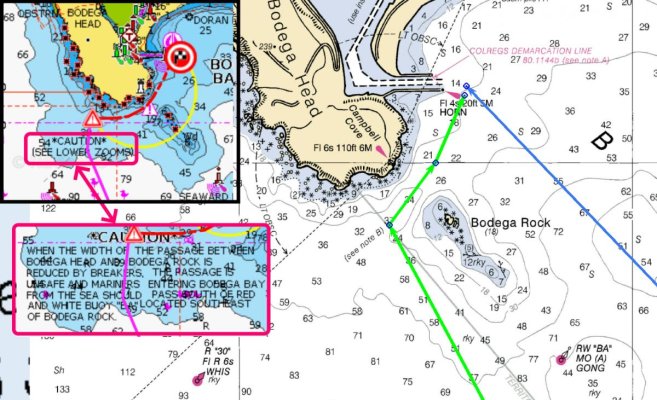
Finally arriving at Bodega auto routing takes me on a bizarre approach ignoring a charted hazard warning. The attached image shows on the left Navionics routing, on the right two I've plotted on OpenCPN. Bottom left the warning that Navionics ignored. Having make that entrance many times I would NEVER run as close to the rocks off Bodega Hd as Navionics put me. Shear stupidity.

To find so many errors on a relatively simple route means that I must review each leg and waypoint. It means that I have lots of corrections to make. It is much better in my opinion to create the route manually.

I do understand that for those who's systems are MFD plotters that manually plotting a route is a chore. That has been acknowledged by several posters here. And that is why my preferred nav tool is good software on a computer with a mouse or trackball.
 

Attachments

  • San Fran VTS.jpg
    San Fran VTS.jpg
    200.3 KB · Views: 15
  • bodega approach.jpg
    bodega approach.jpg
    166.5 KB · Views: 17
Interesting. I received an email reminder notice that my Navionics subscription had expired.

This notice was at the bottom of the page.

"Autorouting is for planning purposes only and does not replace safe navigation operations."
 
"Autorouting is for planning purposes only and does not replace safe navigation operations."
Yes, I see the same warning. Given the need to go over the route in detail and fix a lot of errors I'm not seeing the value in auto routing other than ease of use on a MFD system.
 
There is no way in hell I'd let a Tesla autopilot take control in traffic. On a long empty route through the desert? Maybe. Probably.

For Grandma who won't give up her car but is now an awful driver, autopilot would be safer behind the wheel than her.

I totally get it there are places and times when over-reliance on it is unsafe.

To throw away the tool altogether makes as little sense as using it 100% of the time regardless of conditions. Seems to me that this is one of those things where absolutes are not the way to think about it.

If it helps, use it. If not, don't.
 
I asked Navionics to give me a route from San Diego harbor entrance to Bodega Bay entrance, a run I've made many times.

Shear stupidity.

To find so many errors on a relatively simple route means that I must review each leg and waypoint. It means that I have lots of corrections to make. It is much better in my opinion to create the route manually.

Wow, I just ran that route on the web app and, yeah, you're right about poor choices. I may have my boat specs config'd for a 4' draft but practically driving me through the surf break seems like a BAD PLAN.

It'd be interesting to see what kind of router a Garmin unit would do, if the routing software is any "less stupid" or not.
 
Last edited:
I think it best to think in terms of minimal acceptable depth which varies depending upon the cruise being planned. This morning for the San Diego to Bodega run I used 30 ft. If I were to try again I might use 100 ft. To get me further from rocky shores.

This points up one of the weaknesses in auto routing. I will plan my route not on a fixed depth, but on a depth that will vary throughout the route. Shallower in bays. Deeper once off the coast. As deep as 600 ft when crabbing is active. To get me past the shelf break where the crabbers don't go.

This gets back to experience and local knowledge. Something auto routing is not good at.

This reminds me of a conversation with a road routing software developer some decades ago. This after the routing software chose to route through a VERY problematic part of town. Both from a personal safety and road conditions standpoint. The shortest-path-first routing was less than ideal. The conversation touched on management having to grapple with 'bad part of town' in a way that wasn't clearly and outrageously biased (and there's no good way to make that point, so let's not let the conversation devolve on that angle). So, yeah, local knowledge remains key.
 
Use it all the time. It produces the 90-90% solution. Has saved me tens of hours of time plotting courses over the last 3 years including the Loop.

BUT nothing replaces looking at the route and insuring that it goes where you want it to go. I don't load it into auto pilot and forget it. I just follow it, carefully.
 
I can’t express my opinion on other than Navionics. I’ve found it to extremely accurate. But, you have to enter your boat requirements first. It will plot a “safe” route based on that info. You still need to pay attention to your route when you’re under way. That’s common sense. I don’t use it for autopilot, although I can export my routes to my Raymarine mfd. I’m in the northeast with plenty of boobytraps. I don’t go around the corner for fuel without my Navionics. It’s just what I do.
I want to add, you must subscribe yearly to Navionics for autoroute to work. Your old routes are saved, but you can’t make new routes without their inexpensive license.
 
I can’t express my opinion on other than Navionics. I’ve found it to extremely accurate. But, you have to enter your boat requirements first. It will plot a “safe” route based on that info. .

No, not always
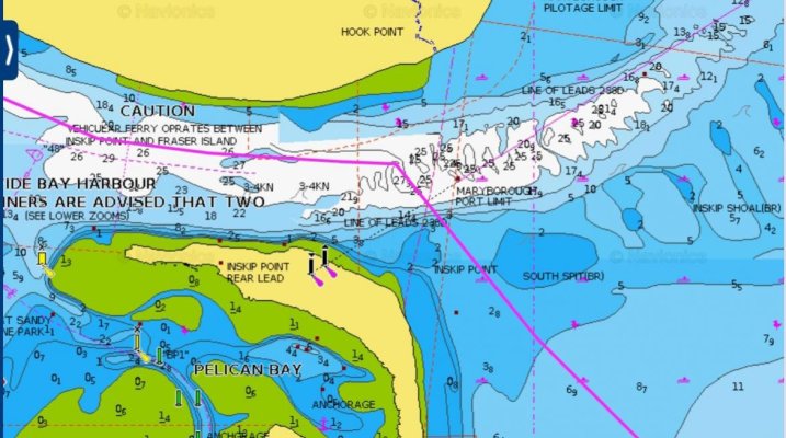
This one of the most notorious bars on the east coast of Australia.
This route in calm weather would likely have us aground
In any other weather would have us wrecked and lives lost


You can clearly see the line of the leads, proper entrance is to the far right of screen.

I have used that route many times on multihulls with dagger boards, but never a vessel that draws more than 1.2m
 

Attachments

  • Screenshot_2021-03-23-05-42-37-041~3.jpg
    Screenshot_2021-03-23-05-42-37-041~3.jpg
    120.5 KB · Views: 12
Last edited:
Autorouting

Normally I wouldn't respond to this but your comments are extremely off base.

We have a full Garmin suite. 8616xsv chartplotter, 24 Fathom radar, 800 AIS and an autopilot with shadow & smart pump.

I can speak to this setup as I have used it since '16 to do 1/2 of the Loop. Don't know Agate Pass and letting you go thru there, but did the cut in Canada to Kilarney and touched the remote I use to control the autopilot 4 times as boats approached from the opposite direction. Just being safe.

I trust the autopilot because I am sitting on the bridge watching what is going on.

IF I don't like what I see or what is approaching I can take the wheel. 1 does NOT preclude the other.

On the chartplotter, any route that is shown is adjustable, by you, before you 'lock in' the course, which of course isn't locked in any more than if I was driving by wheel alone. I guess those who said, couldn't go thru, didn't know how to make the adjustments.

Great advantage, online Navionics, for route planning, but the adjustments you can make there, you can make on the chartplotter.

Your comment, "Beyond that I want to plan my route, make the decisions and be aware of obstacles and potential trouble spots", yes, you can do all that with the chartplotter, autopilot and steering wheel.

The most amazing sight I had when the equipment was installed was looking aft. The wake made us look like we were on rails. Straight as an arrow. You can't do that with a wheel.

Manipulating a wheel for a couple 3 or 4 hrs is tiring, having the autopilot steering, much more relaxing. Allows you to stay focused much better. My head is 360 without worry about where the boat will end up while I'm checking the surrounding.

Usual comments like those presented are generally from someone who has never experienced the benefits.

Be glad to discuss it further, drop me a line.


If you are discussing an auto pilot using a chartplotter route versus hand steered...no kidding.


But if I understand the OP correctly, the autopilot doesn't know whether the route is automade or manually made. I thought the question is...."is autorouting all it's cracked up to be"....not autopilot steering.


Again...not sure you are on the same page as the OP was intending.
 
Last edited:
My bridge ht is not considered in auto route .

Nice to see it for the options but check every inch or the route

M/v persistence
 
I use it for planning. I prefer to chart my own course and use autopilot to steer.
 
Back
Top Bottom