Active Captain Information on older plotters

The friendliest place on the web for anyone who enjoys boating.
If you have answers, please help by responding to the unanswered posts.
I read Jeff Siegel's (Active Captain) email today and I am a little puzzled as to how this will work. I understand that they can add the current AC database to a chart chip, like C-Maps. But how do you update it? I don't want to buy new C-Map chips every month.


You would need read/write non volatile memory on the chip and an internet connection to make this work. Some newer chartplotters might have that capability, but not many and no older ones.


Jeff, can you explain?


David
 
That is the rest of the story we have yet to hear. I would hope for a way to do a update without buying a new chart card each time. The area I normally boat on the inland rivers a annual or semi-annual update would suffice for me because the anchorages and marina information is what I use. The navigation information that boaters on the icw or the gulf coast would need should be updated weekly or better yet daily to be useful. It'll still be updated every time I use AC .


Sent from my iPad using Trawler Forum
 
Chartplotters, especially older ones, don't have the ability to update live. Much of the ActiveCaptain data is fine to have with each chart update (available quarterly) and there are some nice update programs coming to get automatic updates on physical media.

All of the markers are present along with all reviews. Pricing is all dated. If you remember Skipper Bob, he used to put all the fuel prices and slip prices once per year. This static data will be updated 4 times per year which is as good as it can be done practically for physical media.

It's giving you a great reason to keep the charts up-to-date. This all becomes easier if the C-Map price to do that is reasonable. For what it's worth, we don't get any fees from the chart updates at all.

As chartplotters are able to connect live, we'll be in a position to synchronize them just like all the apps or even the Furuno chartplotters which support ActiveCaptain today too.
 
My Garmin software, "HomePort" integrates with active Captain. I can see all the marinas, anchorages, etc. and all the comments. I plan my routes on HomePort and then upload them to my Garmin 5208 plotters.


Will I be able to upload marinas and anchorages as well?
 
Seems like decades between soundings measuring water depth. "Updated" charts aren't all that they should be.
 
My Garmin software, "HomePort" integrates with active Captain. I can see all the marinas, anchorages, etc. and all the comments. I plan my routes on HomePort and then upload them to my Garmin 5208 plotters.


Will I be able to upload marinas and anchorages as well?

I can't comment on projects we're involved with Garmin on. We have an incredible relationship with them - HomePort is an example of the collaboration.
 
I can't comment on projects we're involved with Garmin on. We have an incredible relationship with them - HomePort is an example of the collaboration.
I guess I'll just stand by and wait. I can use HomePort while cruising so it's just a matter of leaving the helm or planning stops the day before.
 
Seems like decades between soundings measuring water depth. "Updated" charts aren't all that they should be.

I had the privilege of writing a hazard reporting system for NOAA. I also helped them design their new tile publishing system for chart tiles.

Bottom line - they update about 100 charts every week these days. I get to see the hazard information going into cartographers and the resulting chart tile updates about a week later. There is a tremendous amount of chart updating taking place these days.

I'm currently working with MCGA (the UK's Coast Guard equivalent) to produce a similar reporting system. There is a wonderful mix between cartography and crowd-sourced information to feed back to us boaters to produce better charts. It ain't what it used to be.
 
I guess I'll just stand by and wait. I can use HomePort while cruising so it's just a matter of leaving the helm or planning stops the day before.

Get an iPad (or even an iPad Mini) and Garmin's BlueChart Mobile. Use it away from your chartplotter and keep it mounted near your chartplotter while underway. It provides a fantastic backup chartplotter and gives additional information today (live weather and offline ActiveCaptain data). It's a great combination for avoiding hazards if you're in a waterway area.
 
Get an iPad (or even an iPad Mini) and Garmin's BlueChart Mobile. Use it away from your chartplotter and keep it mounted near your chartplotter while underway. It provides a fantastic backup chartplotter and gives additional information today (live weather and offline ActiveCaptain data). It's a great combination for avoiding hazards if you're in a waterway area.

True, and that's exactly wat I do. But, from someone who has three Garmin chartplotters onboard, count my vote strongly in favor of making AC accessible on my chartplotters.
 
True, and that's exactly wat I do. But, from someone who has three Garmin chartplotters onboard, count my vote strongly in favor of making AC accessible on my chartplotters.

I have three as well. It has my vote too.
 
Get an iPad (or even an iPad Mini) and Garmin's BlueChart Mobile. Use it away from your chartplotter and keep it mounted near your chartplotter while underway. It provides a fantastic backup chartplotter and gives additional information today (live weather and offline ActiveCaptain data). It's a great combination for avoiding hazards if you're in a waterway area.

I have an android. I can't really change. AC is very blurry on it and useless. Am I doing something wrong?
 
I have an android. I can't really change. AC is very blurry on it and useless. Am I doing something wrong?

Well, it's not wrong but you could be doing something much better.

The Companion app is an experimental app that talks to you as you're approaching a hazard. It's going to disappear this year as the technology for it moves into the Locations app which will be the single, ActiveCaptain app that we produce. I wrote both apps.

Most likely, you want nautical charts with ActiveCaptain data on the Android device. For that, I'd look at MX Mariner especially for the US, and Jeppesen/C-Map Plan2Nav for international use. MX Mariner is a couple of dollars and well worth the cost if you use NOAA charts.
 
I can definitely support Jeff's recommendation of MxMariner for Androids. It uses either raster or vector NOAA charts that you download region by region.


You enter your Active Captain account information into MxMariner while connected to the internet and it downloads the AC database of about 100 mb. Then you can see the AC icons on the chart, click on the icon and see all of the data.


You periodically need to update the AC database. Takes about 2-3 minutes to update with a fast internet connection on my Nexus.


I have not had very good luck with Plan2Nav, but Jeff has had good service, both with the same device, so who knows.


David
 
Agree MX Mariner is great for the US. I wish they'd offer a way to buy Canadian charts.

Applications and chartplotters including AC data is a great development.

But what I've seen leaves a lot to be desired in terms of actually using that data.

Underway, or planning the night before, we're looking for something specific. An overnight anchorage in a quiet location. A reasonably-priced slip in town. A fuel dock that won't rob me blind.

What do we have? Dozens of little icons that we have to click on, one by one, then click to open the AC data, then click to open the details, then click to open the prices, then click to open the reviews. Only to find out, most of the time, that it's only a day anchorage, or the marina doesn't take transients, or for whatever reason it's not what we're looking for.

The real trick would be to be able to select just the places that have what we're looking for.

The AC website is probably the closest thing there is to the ideal interface. But even that hasn't really had any new search or usability features in a long time. And between Flash and the small form factor, it's not appropriate for phones and tablets.
 
The real trick would be to be able to select just the places that have what we're looking for.

I think you're looking for a capability that isn't realistic to implement. The reality is, you have to be a part of the decision process. You should be examining charts and determining possible areas where you'd like to anchor, etc. Then that'll limit the anchorage marker you should investigate. It's unrealistic to somehow filter the data to, "just anchorages near a grocery store with 8+ feet of depth and protection from the SW". You'll end up with a list that you'll have to manually rule out each item anyway.

Having the data on a chartplotter means the hazards are smack dab in front of you. Some might not apply but it's better to be warned than not.

I'm working on new things full-time. It all gets better and better every day. We try to mix the new things based on feedback and ideas that we think aren't obvious yet. To be honest, almost no one asks for filtering - perhaps one request every quarter. The website does some filtering as a test. In 8 years, about 10 people have used it. If we saw it being used a lot, we'd expand it.

And of course, we license the data (for free). So if you have a fantastic way to create an anchorage selection app, gosh - write it! You can have it sit on top of all the data, synchronized and current, automatically. Charge $9.99 and make millions!
 
In 8 years, about 10 people have used it. If we saw it being used a lot, we'd expand it.

OK, I give up. I never was part of any majority. I wonder who the other 9 are?

Thanks, Jeff, for all you do for the cruising community!
 
OK, I give up. I never was part of any majority. I wonder who the other 9 are?

You actually make a really great point. The truth is, hundreds of people said in 2007 that no one would update ActiveCaptain to make it worthwhile. So sometimes, you have to be apart from what the majority thinks.

I think there's a better way to give the same effect as data filtering. What if you could show only the anchorages where your friends had been before? Or perhaps people with your type of boat? Or perhaps trawlers? Or even, people who affiliate themselves with TrawlerForum? That's a different kind of filtering that's a little higher up on the benefit side of things (instead of filtering on the raw data side). That's something I'm working every day on...
 
What if you could show only the anchorages where your friends had been before?

I'm also one of the last 10 people on the planet who's not on Facebook, so I'm not qualified to answer that ;)

Still, I think you may be on to something. I am signed up for eBoatCards. I look forward to the day I can see if anyone anchored or underway near me belongs to the same groups as me.

Anything that can categorize the reviews has got to be a good thing, and becomes more valuable as the number of reviews grows. The most frustrating thing about AC now is the less popular locations that don't have reviews, or worse yet, have only poor-quality reviews that contain no helpful information.
 
if MX mariner is good for Androids what is good for apple as my AC is blurry also.
 
if MX mariner is good for Androids what is good for apple as my AC is blurry also.


Might be worth a comment about what means "blurry"?

A raster chart -- as in MX Mariner on a tablet, or on whatever plotter or app you're using -- zoomed WAY in might give the impression "blurry." In this case, just zoom out a bit and see if the presentation starts getting better.

I dunno this AC thing on a tablet that you're mentioning, so can't comment about that specifically... but if it's presenting a "map" of some sort, might be similar issue. But I've only used AC via their website on a desktop/laptop decent sized monitor, or AC info imbedded into other programs and apps (NN3D, MaxSea Time Zero, MX Mariner, Plan2Nav).

-Chris
 
I'm also one of the last 10 people on the planet who's not on Facebook, so I'm not qualified to answer that ;)


Nah, plenty of us out here.

Indiscriminate "liking" and "friending" and "following" and so forth: Yuck.

-Chris
 
if MX mariner is good for Androids what is good for apple as my AC is blurry also.


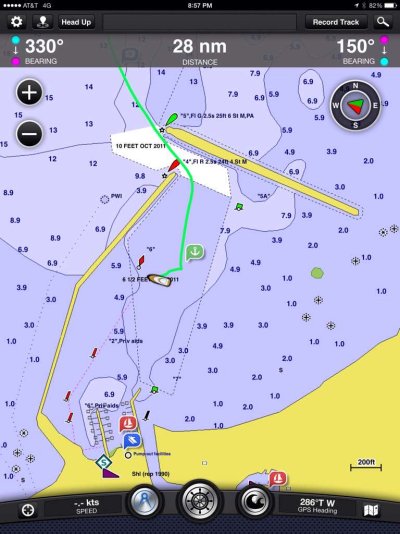
I use Garmins BlueChart Mobile and really like the charts for planning with the AC overlay. ImageUploadedByTrawler Forum1455307363.696995.jpg

This is a screenshot from a delivery in 2014.


Sent from my iPad using Trawler Forum
 
The Companion app (I wrote it) was experimental in nature. It uses lower resolution map backgrounds and gets "blurry" as you zoom up. It's going away in 2016, being replaced by Locations which handles full map/chart resolution. That won't be a normal navigation app either - it'll do other things that navigation apps don't do.

For real navigation use on iOS, there are many apps - check out:
https://activecaptain.com/navProducts.php

Garmin, Aqua Map, Navimatics (different from Navionics), Skipper...and others all work great. Look for other comments to see which is best for you.
 
Back
Top Bottom