$5,000 to spend on NAV system?

The friendliest place on the web for anyone who enjoys boating.
If you have answers, please help by responding to the unanswered posts.
Anyone that's cruised the Okeechobee waterway will occasionally see the chart plotter show the boat on land thus being as much as 100 yards off. This has happened to me using both Garmin and C Map electronic charts.

So I wonder if the NOAA charts themselves are off.
 
This argument highlights the quality of the charting in North America generally. I have had the opportunity to compare charting by Canadian Hydrographic Survey charts, which I use on my laptop, with C-Map, which I use on my small plotter. There are inaccuracies in the C-Map, when comparing the two, from time to time, but rarely errors in the CHS.
In Turkey, where I was fortunate to charter a sailboat a few years ago, each boat had a single chart, printed on waterproof paper so you could use it in the cockpit. In the fine print the chart revealed that the survey on which it relied was done by Beaufort, and in the sailing directions came the warning that the datum could be up to 1 mile off. This was easily confirmed when entering harbours, as we had a plotter aboard that showed our position accurately, but the chart in the plotter, derived from the same survey, showed us to be on land most of the time.
 
I have a built in reminder every time we leave our berth that the chips can be out of date, so never to take the position on the GPS as gospel if you eyes say otherwise. The area of our marina we now traverse to get out to the entrance is still shown on the chip as solid land, even tho it has been excavated and opened up for at least 4 yrs. I guess I'll get a new chip one day soon, but for now it is still accurate everywhere else we go, so it waits its turn....
 
Is pinpoint accuracy that necessary? I must be missing something.
 
Is pinpoint accuracy that necessary? I must be missing something.

No..but it comes in handy every once and awhile,,,and pinpoint to me is within 10 feet or so...less than that and antenna placement can cause as much confusion/error if you are trying NOT to hit a fixed object.:D
 
So all this just reaffirms why I plan with paper charts, plot my course on my electronic chart, then keep my paper charts close at hand. Maybe the best invention is the track feature... You just have to get there once to get there again. Wonder if any company has come up with a way to share tracks? That would be something!!!
 
So all this just reaffirms why I plan with paper charts, plot my course on my electronic chart, then keep my paper charts close at hand. Maybe the best invention is the track feature... You just have to get there once to get there again. Wonder if any company has come up with a way to share tracks? That would be something!!!
I guess that's essentially what I do also. I don't use charts, because I find their size cumbersome, but we are lucky to have a publication updated yearly called 'Beacon to Beacon' that covers our part of the coast and Moreton Bay in detail, with all sorts of extra info including overhead photos of the anchorages etc.
I refer to it and check the GPS against it all the time.
Trip Planner Australian Marinas Guide QLD Marina - Cruising Guide Beacon to Beacon Queensland
 
Just remember it's the paper charts that are off too...unless they are a VERY recent datum change.

The only thing that will keep yo off the rocks/beach in the goo is a good radar and well honed observer.

When it's clear...a cheap pair of eyeball will work!:socool:
 
To put it another way, you've got three instruments on board to tell you the actuality of the world around you: binoculars, depth sounder, and radar. The chart plotter and the paper chart represent estimates, I call it a "theory", of where you might be in the world. Most times, those estimates are extremely accurate. An experienced and skilled paper chart navigator can be amazingly accurate with the addition of an accurate speed log. But see the recent incident of the Navy ship ending up on the reef in the Phillipines. Turns out one set of electronic charts they have was inaccurate, they should have been using another set.

On waterways like the Intracoastal or the California Delta network, all you need are those first three instruments and even then you can get away without radar if you just stop the boat when the fog sets in. I like having the chart book open to get the big picture of the voyage and as a visual log.
 
Another long reply. :facepalm:


I been at the Seattle boat show several time, first time I talked to the major brands, Furuno, Garmin, Raymarine, and Nobeltec software. the second time I talk to the 3 major installers of all the major brands. Furuno was #1, but as user friendly, Raymarin was #2 but was not compatible with other brands, and Nobeltec software as it was bought by Furuno, Garmin was not even mentioned and other brands where mentioned but do not have a complete package. The installers sounded like different brand can be mixed and matched as they are compatible. If I was going to mix and match I would use an installer as they might be able to get better deals than I could so there service is free. Remeber I am CHEAP!:D


Being able to load the electron charts on to a PC is primary important to me, so I can plan and simulate routs at the office, so I ma very interested in Nobeltec being the software with a portable PC. Nobeltec has a special on the Odessey with USB GPS for $199.00 which is a good deal. Odessay does support AIS and has most of the whistles and bells. I bought Chart View 16 years ago, now Nobeltec, with portable Gramin GPS that still works.

Besides electronic charts I am looking at VHF and AIS. They are to separate boxes. At this time there is not VHF that can SEND, only receive, so if you want to received and send you need a AIS box. My understanding is SITEX make most of the AIS for other name brands. The SI-Tex has a GPS included and they are the cheapest. The VHF radio I am looking at is ICOM in the $200 to $400 range.

So I am hoping to up grade the electronic charts with gps for sure and VHF, AIS with gps for under 1 grand thisn summer and than radar added next year for another 2 grand. So 5 grand is reasonable. :socool:

This is sure getting complicated.
 
One thing to watch shows for...is smaller marine electronics places will push certain brands because they need to move them, get a better price point, are easier to install, have better customer relations for dealers than others.....etc...etc...

I worked for a medium size installer in NJ for about 4 years and worked many boats shows with them and for other companies. I'm still good friends with one of the owners and I still see which "way" he leans and whish way the winds are blowing.

We couldn't get Garmin direct for a good price point because they wanted us to have $1M in inventory on out shelves....:eek:...we didn't have a half of that with 10-15 other brands total. So we had to buy from a distributor and pass the points along to the customer so Garmin wasn't competitive for us to sell.

Some manufacturers really discount for shows and some don't (although this last recession changes a lot and I can't be sure all is still the same).

So you have to take what you here at shows with a grain of salt....nice place to go and compare though if you miss the crowded days!
 
I went on Saturday and Sunday which are the most crowed days. However, I ma told my present demand attention, so I usually do not have to wait long. I dress to impress and shock factor! I tend to like being perceived as an air head so I can ask all the no tech questions. I also like to stand back and just listen to what others are talking about of its on a topic I am interest in. I have not quite got it clear in my head and/or wrapped my arms around the whole electronic thing yet. :confused:

Other then the Garmin representative mentioned Garmin and they are the most expensive by at least 50%. I did find the installer to be more knowledgeable and informative. Both Furuno and Raymarine have the capability of their software being loaded on to a PC. Which is my primary driving factor as I like to preplan and simulate the cruise. So right know I can open the Chart View, open AIS internet site, buoy sites and have a good idea what is out there. :socool: So why leave the dock? :confused:
 
Be very wary of Nobeltec Odyssey. The night dimming feature when used with AIS is NOT able to change the colors of the AIS contacts names. At night the names are Non existent. Also the Currents/tide feature isn't available. We talked to Nobeltec about the issues and they sheepishly said that they knew that they had "some" issues withit. They were not actively working on the "issues at this time. This was last spring.
We had to go back to our Nobeltec VNS which we like, but our office it guy tried to slip this one by us. It didn't work. There were some really nice features on it. If you don't intend to travel at night it would be all right. Certainly not suitable for commercial operators.
 
Another long reply. :facepalm:
Being able to load the electron charts on to a PC is primary important to me, so I can plan and simulate routs at the office, so I ma very interested in Nobeltec being the software with a portable PC. Nobeltec has a special on the Odessey with USB GPS for $199.00 which is a good deal. Odessay does support AIS and has most of the whistles and bells. I bought Chart View 16 years ago, now Nobeltec, with portable Gramin GPS that still works.
Phil,
I believe most of the chart-plotter makers have PC software. In Garmin's case they have homeport which anyone can download for 25 bucks. You then download the charts from your plotter to a SD card, load that in your PC and you can pre plan trips and make routes which you then download to the SD card and then into the plotter. If you have a lap top you can do that on the fly.
 
Be very wary of Nobeltec Odyssey. The night dimming feature when used with AIS is NOT able to change the colors of the AIS contacts names. At night the names are Non existent. Also the Currents/tide feature isn't available. We talked to Nobeltec about the issues and they sheepishly said that they knew that they had "some" issues withit. They were not actively working on the "issues at this time. This was last spring.
We had to go back to our Nobeltec VNS which we like, but our office it guy tried to slip this one by us. It didn't work. There were some really nice features on it. If you don't intend to travel at night it would be all right. Certainly not suitable for commercial operators.

So are the little boat symbols there? What if you do not use the night dimming feature?

They are offing raster or vector charts. My old Chart View uses raster charters which I like as the letter/number get bigger as you zoom down, which I need as I grow older. :oldman: Being old school I am use to having each application on its own screen, and not have the screen to clutter. What kind of charts do you like? rastor/vector

The Odyssey, 200.00 bucks, comes with a GPS which will work for me. Then in spring get a new VHF and AIS which is really primary reason. The Si-tex transreceiver, send and receive, seems to be the cheapest. The new back up radar with separate screen is next years boat birthday present. then we will have back up for all the electronics. Then I need to be WEANED away from the dock. :eek: :D

I having on a portable PC is a must because I can/have taken it on the run about, other boats and loan it to friends as it has a portable GPS.
 
Phil
First of all I use Nobeltec on a daily basis all day every day I'm at work. I really like it. Our company IT guy gave us Odyssey to put on backup computer and try out. I also like laptop (ships are on 23' screens) Nav systems with a dedicated chart plotter backup. Personally I use Vector charts, but it is a personal choice. The oddyssey was literally removed from the wheelhouse and remains on a back up to the backup. The IT fellow was given a earful by yours truly. I can't remember all the issues (several) but most had to due with dimming/night features that are already on other nobeltec.
The tide/currents issue was the one area which is a game changer for commercial operators. Docking and undocking barges/workboats and ships require this info at your finger tips. We all can do it old school, like we used to- with the books, but it is 2013.
I used open CPN on a recent delivery and it worked great. Add a $40 USB GPS from Amazon, and your in business. I still believe in having a dedicated plotter as well. Most of the features I use every day are on Open CPN for free.
 
SoF...agree 100%...just came 1000 miles on my setup and it's very easy to use....plot and modify active route/waypoints, full time tides/currects...easy peezy...
 
Phil
First of all I use Nobeltec on a daily basis all day every day I'm at work. I really like it. Our company IT guy gave us Odyssey to put on backup computer and try out. I also like laptop (ships are on 23' screens) Nav systems with a dedicated chart plotter backup. Personally I use Vector charts, but it is a personal choice. The oddyssey was literally removed from the wheelhouse and remains on a back up to the backup. The IT fellow was given a earful by yours truly. I can't remember all the issues (several) but most had to due with dimming/night features that are already on other nobeltec.
The tide/currents issue was the one area which is a game changer for commercial operators. Docking and undocking barges/workboats and ships require this info at your finger tips. We all can do it old school, like we used to- with the books, but it is 2013.
I used open CPN on a recent delivery and it worked great. Add a $40 USB GPS from Amazon, and your in business. I still believe in having a dedicated plotter as well. Most of the features I use every day are on Open CPN for free.


Thanks:flowers:


I really like the tide/currents when planning a cruise as with out 6 ft draft and max 10 kts that are many areas we can not go though until high/slack tide. The animation is great to plan and you can plan months in advance. Like it we were going to Trawler Feast, mid May, I can plot a course, animate the tides/currents to see the best course and time. Not that we would actual take the Eagle as we can drive up and be back in 4 hours. :facepalm:


Where the old radar use to be, I have a 17" screen as I prefer small lap tops, slim/light weight, for easy of carrying. The Eagle bridge is 9 ft long and 2.5 ft wide so there is plenty of space. My Sony is just big enough that I do not fat finger the keys. I now carry a Samsung Galaxy tablet with Verizon 3G as it fits in my side suit pocket. There is android app for charts, but I have not looked at it. We been going portable and wireless for everything if possible. :socool:

200.00 bucks with a gps is not a bad deal as I am cheap. Now to find the cheapest AIS transreceiver? Maybe I don’t need a new VHF as AIS is a separate application have not quite figured that out yet.?:confused:
 
I used Nobeltec for a long time, but finally gave up on them. As a bunch of ex-Microsoft folks, they update it constantly, and you are forced to keep paying to upgrade. If you skip an upgrade or two, they most recent one becomes more and more expensive. You really never buy it, you just rent it. Went to Rosepoint's Coastal Explorer.
 
I don't use paper charts! Why would I?
There is no way anyone could plot your position on a paper chart using a hand bearing compass or dead reckoning or with a depth sounder as accurately as a chart plotter can.

In the areas I cruise of the GICW, exact positioning is necessary if you plan on cruising and anchoring in the very shallow areas and narrow channels we do. Before electronic navigation you stuck to the marked channels or carefully plotted and estimated your distances between markers if you left the marked channels or you had local knowledge. Now with a chart plotter you can decide to anchor at a beautiful spot as you pass it without having to take the time to determine on a paper chart if it's even possible to get to.

When we were in the Bahamas last year we anchored off the south end of Great Sale Cay with a stronger than predicated southerly breeze. We soon decided we could not get a good night sleep here bouncing around. So I looked at my trusty Garmin chart plotter and found a spot 5 miles away on the west side of the Cay with a slight indentation that looked protected from the southerly breeze. Only problem was a shoal area that extended out from the Cay about a mile that had to be avoided. No problem we just cranked up the ole trusty Cummins headed for the new anchorage and avoided the shoal by about 100 yards. 30 minutes later we were sipping rum and cokes at out new very smooth anchorage. Had we had to paper chart our way to this new anchorage we would have had to estimate our distance from the shoal by taking cross bearings and reading the depth. That's a real pain in a bouncing boat. Ever try an bring out a chart when you're doing 18 kts!

Yes I do carry paper charts but have never had to refer to them. I also carry 2 hand held GPS's in addition to the 2 chart plotters on the helm and the navionics on my cell phone.

As to the original posters question: Any of today's plotters will more than do the job. The bigger question is what are your preferences. Personally I love my Garmin touch screen. I'm not advocating Garmin but I really do like the touch screen and if you're going to use the chart plotter over several years personally I think that option is worth the extra cost. Just my opinion.

Wow, love my old Sextant and Paper Charts as a Backup. I still plot every hour our GPS position on a Good Old Paper Chart.
 
I received Nobletic chart with GPS for 200 bucks. So I been looking and pricing AIS. I been told that SI-TEX build most of the AIS for other brand, and if you look the box and the instruction/manual are basically the same. There are two types of AIS, A receives only about 300 to 500 bucks, and B, transceiver, sends and receives, for 500 to 1,000 bucks depending on the brand. I being cheap am looking at the SI-TEX, sold by a number of installer and EM-TRAK sold by West Marine both about 550 bucks which include programming then SD card with you vessels information, Both have an internal GPS and comes with an external GPS, a power/data cable and a USB for a PC. Both require own external VHF antenna which is a small wipe for 50 bucks.

I have talked to several installers and not many Pleasure boats have AIS as it more of a commercial requirements. The few pleasure boats I have see that have AIS are 60+ ft, so most of the boat show representative were not very helpful and referred to installers. I will proable install in July when the weather is a little nicer and we MIGHT, I said might leave the dock. :confused::D

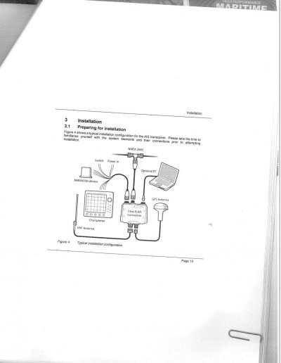
Copy of installation diagram
 

Attachments

  • AIS.jpg
    AIS.jpg
    80.1 KB · Views: 91
Last edited:
For what it's worth

I too need to upgrade/refit my electronics and found this thread interesting. I recently (November) had to move my boat from Baltimore to FL. The old Northstar plotter has a great display but worked intermittently as did the Furuno radar. I have already put about $2k into that old radar and think it's time for a new one. I also have Coastal Explorer on a Panasonic toughbook with a built in GPS as my backup. About half way between Moorhead City, NC and Fort Pierce, FL on a "dark and stormy night", the radar decided to quit and my toughbook shutdown because the battery was not charging (another problem to deal with). We also noticed the house voltage was dropping below 12v. I shut down all but essential circuits to preserve power. Since I still like my paper charts we had a constant plot of our position using a GPS (I have two Furuno GPS-30 on board and two handhelds). After 65 hours underway we passed R2 at Fort Pierce. I had estimated our arrival to be 0430 and only missed it by 30 minutes. The bottom line is when "stuff" hits the fan, your chart, parallel rules, and dividers won't let you down.
I have decided to go with the best Furuno radar I can afford and use Coastal Explorer on my laptop. I have used CE for several years and can't recommend it enough. I have in on a Macbook Pro running a windows emulation program and also on the toughbook. But, I use the PC plotter to verify my plot on the paper chart.
 
The CE website hasn't been updated for some time. Is this still a going concern?
 
Not sure what you mean by going concern but the CE forum looks to be active.
 
ptlones--Excellent point! When it hits the fan, lesson number 1 in all of this is you'd better know how to navigate using the old standby methods. He who fails to learn them, or maintain navigational skills--easy to do in this butt dumb age of chartplotters--deserves thr consequences.
 
Not sure what you mean by going concern but the CE forum looks to be active.

Yes, now I see the support forum has some activity. Earlier I looked at their cruising forum and noticed it wasn't very active.
 
Regarding under 5000 buck upgrade, I just broke my bank with the GPS store booth at the Miami Boats Show. Garmin lowered the prices of their 5200 and 7200 series MFD's the day before the show. We narrowed the choices down to Simrad's PSS 12" and the 5212 Garmin, but during the final comparison, the extra $500 for the twin processors of the 7212 didn't seem so out-of-line when we asked both machines to do some heavy-duty calculating or video. Both the 5200 and 7200 series screens could be split into four different views of most anything, but when asked to display a video input alone, the 5200 series could only manage a 5 X 7 screen size while the 7200 could do full screen. When looking at camera video of engine rooms etc. and enlarging for detail, the twin processors really help. So we did it. A 7212 with 18" Garmin radar dome and a sound box for bottom detail, plus a detailed chart card (you know, in addition to the charts it has bottom very detailed bottom contours, 3D mockups, satellite views of water, land, marinas, inlets, and on and on) for southern Florida and Bahamas, all stuff that my Admiral plays with, and of course the backbone and everything to hook-up the system minus the transducer (not sure if my current unit will work with it), $4650.
 
I've been a Coastal Explorer fan for about 6 years now but it doesn't do everything. On a new to us trawler, I labored over an electronics upgrade from a 5 inch Standard Horizon along with 2 Humminbird fish finders to add to Coastal Explorer. Coastal Explorer is my primary at the lower helm, and an IPAD with remote screen display of Coastal Explorer is the upper helm. After a month of comparing systems I went the Lowrance route with an 8 inch screen at the lower helm and a 7 inch at the upper helm. These will mainly be used for depth and backup navigation. The boat already has a separate Raymarine radar with SLC-70 display. When that dies, I will opt for a 4G radar. I didn't really understand the previous comment from way back that Lowrance is really made for the bass boat crowd. The array of transducers is quite large. I encountered a garage sale price on a Structure scan module and transducer that I plan to transom mount. Yes, it is an experiment, but I want to see what kind of information I can get from the sidescan sonar when anchoring. Plus the downscan resolution should help determine hazards to the anchor on the bottom (logs and the like).

Tom
 

Latest posts

Back
Top Bottom