Windy Definitions

The friendliest place on the web for anyone who enjoys boating.
If you have answers, please help by responding to the unanswered posts.

menzies

Guru
Joined
May 11, 2014
Messages
7,233
Location
USA
Vessel Name
SONAS
Vessel Make
Grand Alaskan 53
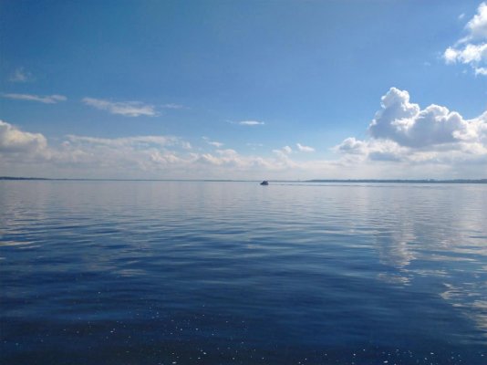
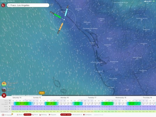
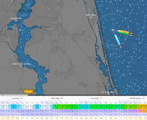
Thinking of running off shore tomorrow between Mayport and St Augustine. Windy is showing waves of 3 feet and swell of 3 feet.

Their definitions are:

Waves: Significant wave height and its period of all wave types combined (swell and wind waves). Close to the shoreline, the actual height is influenced by the shape of the sea bottom.

Swell1: A swell consists of wind-generated mechanical waves that are not significantly affected by the local wind at that time. They have been generated elsewhere and some time ago, usually travelling long distances.

So is total height (wave and swell) three feet or is the total height six feet?

Big difference comfort-wise!
 
Uncomfortable in a small boat. No problem if on a ship.

Preferred:
 

Attachments

  • smooth waters.jpg
    smooth waters.jpg
    70.7 KB · Views: 41
Big deciding factor is time between swells. 3 ft at 15 seconds no problem, 3 ft at 5 seconds a different story. Take in to consideration direction and speed of wind. Windy is my go to for weather. Drop a mark on the area your concerned, bottom left of windy will have a tab pop up, click on the waves and go from there.
Cheers
 
One of the reasons I prefer passageweather.
Free(although I contribute regularly)
Multiple models easy to see
Arrows instead of colors. Easy to interpret and think about.
Easy access on slow devices (SSB) or when time is expensive (satphone, Fleet)
Easy to manipulate and download on any device.
Uses the definitions recognized internationally so easy to compare to text forecasts.
All these services are just repackages of free information. You pay for NOAA with your taxes.
 
Last edited:
The 3' swell would be fine and the 3' wind waves wouldn't bother us on Beachcomber. Makes for an interesting ride. Here's a video of us running in much larger waves and enjoying it.

 
Big deciding factor is time between swells. 3 ft at 15 seconds no problem, 3 ft at 5 seconds a different story. Take in to consideration direction and speed of wind. Windy is my go to for weather. Drop a mark on the area your concerned, bottom left of windy will have a tab pop up, click on the waves and go from there.
Cheers

Yes, but if Windy is showing 3 foot wave and on the next line 3 foot swells, is that three feet total or six feet total?

See screen shot. First grey row is waves, second grey row is swell.

Bottom line is period.
 

Attachments

  • Windy.jpg
    Windy.jpg
    133.7 KB · Views: 48
Remembering back to my 1970 masters degree in oceanography, wave height is usually defined as "significant" wave height which is the average of the highest 1/3 of the waves. You'd have to ask windy if that is the definition they are using, but I suspect it is. Swell is generated away from the local area where it is experience and sweeps in as usually longer period humps (or waves if you like). Wind waves, which are called waves for short, are generated locally by the wind blowing over a fetch (stretch of water). Short definition of the life cycle is swells began life as wind waves somewhere.

So to your question. If a swell of X feet sweeps in to an area off Mayport in a calm, you only got swell. If a wind whips up making for significant wave height of Y, the total heave you COULD be subjected to is X plus Y, but it is not going to be consistently that because of different wave train directions and periods. It's a confused sea when directions of travel are deviant by a large degree. I would not have run my GB42 in 3 plus 3 sea/swell. Very uncomfortable, but then I am a wimp. After a career taking ships to sea when told to by others and suffering the consequences, I am now a smooth water sailor. :)
 
Last edited:
The 3' swell would be fine and the 3' wind waves wouldn't bother us on Beachcomber. Makes for an interesting ride. Here's a video of us running in much larger waves and enjoying it.

Yes, but there is no time saving versus going down the parallel AICW in comfort. Just fancy filling the holding tank up with water tomorrow and after a couple of hours sloshing about outside the three mile line, clearing it.
 
They are as advertised: - a 3' (old) swell from the direction denoted by the arrow, with a 3' wind driven wave action from a slightly different direction (second arrow) - pretty normal on the ocean, but also common on the Great Lakes. It doesn't mean that the waves are always additive but yes, potentially you will see some 6+ footers where the two coincide. How often that happens and how unsettling you find that depends on their periodicity.
 
They are as advertised: - a 3' (old) swell from the direction denoted by the arrow, with a 3' wind driven wave action from a slightly different direction (second arrow) - pretty normal on the ocean, but also common on the Great Lakes. It doesn't mean that the waves are always additive but yes, potentially you will see some 6+ footers where the two coincide. How often that happens and how unsettling you find that depends on their periodicity.

Period looks like between 5 and 6 seconds.

Will probably just head on down the AICW unless I see a change tomorrow morning.

BTW, was in your beautiful marina and club a few weeks ago. Had a wonderful time.

https://www.trawlerforum.com/forums/s27/october-hilton-head-trip-54123.html
 
Just looked at NOAA:

SUNDAY
South winds 5 to 10 knots. Seas 3 to 4 feet with a
dominant period 5 seconds. A light chop on the intracoastal
waters. Slight chance of showers.

5 seconds is choppy but 4 footers will be fine. I'll see how lazy I get tomorrow morning!
 
Uncomfortable in a small boat. No problem if on a ship.

Preferred:

Yesterday after leaving the Ortega River looking south on the St Johns River.

Paddy Wagon, who we followed out and waited for us to just have one bridge opening, in the background.

80f temp.
 

Attachments

  • St Johns.jpg
    St Johns.jpg
    79.2 KB · Views: 26
I always double check Windy with local NOAA marine forecast. They define waves as "seas are reported as significant wave height, which is the average of the highest third of the waves. Individual wave heights may be more than twice the significant wave height."

USCG will issue a small craft advisory when winds exceed 21 knots and waves exceed 4 feet.

In theory, a period of twice the wave height is doable. In practice, a period of 5 seconds with 3 foot waves will likely be a bumpy ride. Frequently the forecast is 3-5 seas with 10-15 winds. No problem for the rag boats but unpleasant for a long trip on a trawler. The forecast is often wrong so I venture out and if it's only 3 with decent period and some whitecaps I'll go. 5 and numerous whitecaps and my wife will put her foot down. It usually kicks up more every afternoon so I keep that in mind. If I waited for perfect forecasts I'd never leave the marina.

Forecasting seems to be artful interpretation of variable facts. Actual conditions are subject to period, wind direction, wave direction, bottom contours, etc. Trips with an identical forecast can be pleasant and relaxing or moving from handhold to handhold with an iron grip.
 
Last edited:
I always double check Windy with local NOAA marine forecast. They define waves as "seas are reported as significant wave height, which is the average of the highest third of the waves. Individual wave heights may be more than twice the significant wave height."

USCG will issue a small craft advisory when winds exceed 21 knots and waves exceed 4 feet.

In theory, a period of twice the wave height is doable. In practice, a period of 5 seconds with 3 foot waves will likely be a bumpy ride. Frequently the forecast is 3-5 seas with 10-15 winds. No problem for the rag boats but unpleasant for a long trip on a trawler. The forecast is often wrong so I venture out and if it's only 3 with decent period and some whitecaps I'll go. 5 and numerous whitecaps and my wife will put her foot down. It usually kicks up more every afternoon so I keep that in mind. If I waited for perfect forecasts I'd never leave the marina.

Forecasting seems to be artful interpretation of variable facts. Actual conditions are subject to period, wind direction, wave direction, bottom contours, etc. Trips with an identical forecast can be pleasant and relaxing or moving from handhold to handhold with an iron grip.

Understand. However three footers no matter the period on Sonas is fine with the stabilizers on, especially on the bow quarter which is forecast for tomorrow.

Six footers with waves at 5 seconds when I have the option of inside is completely a different conversation with the missus and pooch!

Actually more the pooch as her teeth are slightly more sharper! :)
 
As a general rule I look for period double the swell height.

This is what we have for weather tomorrow on our way to Puerto Vallarta. It will get windy(12 Knots) in the afternoon, then die down to about 5 Knots by 9PM. We prefer calm seas when traveling overnight, especially since no moonlight tomorrow eventing. I dont recall the waves doubling in size when coming from the same direction, if I understand your question right, your asking if the wind wave will increase the size of the swell waves by X2?

Still, 5 seconds on period between swells is short. I cant see the wind speed and that could be a big factor in determining a run of any time in that weather.

When in doubt, take the calmer route when possible, this boating thing is supposed to be enjoyable. When the Admiral and the dog hate you 8 hours from calm, you will feel like a turd for 24-36 hrs.

Best of luck!
 

Attachments

  • D83A50AB-5628-4431-BFF5-6709506DD0E2.jpg
    D83A50AB-5628-4431-BFF5-6709506DD0E2.jpg
    146.8 KB · Views: 25
As a general rule I look for period double the swell height.

...if I understand your question right, your asking if the wind wave will increase the size of the swell waves by X2?

No, it really is a simpler question. Windy shows wave height at three and swell height at three.

Is that an overall height of six? Or based on the definitions I shared above, is it a total of three?
 
No, it really is a simpler question. Windy shows wave height at three and swell height at three.

Is that an overall height of six? Or based on the definitions I shared above, is it a total of three?

I see it as 3 footers not 6.
 
I see it as 3 footers not 6.

I agree. 3 footers say at 8 sec no worries. 3 footers at 4 sec a little choppy, but from which direction and wind speed?

For us going up hill (North) from Astoria to Neah Bay with 3 footers at 8 seconds is great, so let's look at this a little closer.

Weather Prediction: W Seas 3 feet at 7 seconds with S wind at 5-10kts creating a sea chop seas 2 feet.

So for us, Swells and separation are important. We take the swell and double it for a go, no-go. So seas at 3 feet at 7 seconds is almost flat seas. They are coming from the west, so there will be a little roll as we are heading north.

The second part is S winds at 5-10 kts will produce following seas. Maybe a little chop on top, but no worries. Without AP, it will tire you out after awhile.

It all comes down to what you are comfortable with. Your boat will take more of a beating than you will. If you don't like it don't go. My Admiral has veto power on go, No-Go. We both talk about weather.

What will get you EVERY TIME is if you are on a schedule. Weather bad? Stay in port and don't let a schedule dictate a bad decision.:thumb:
 
I see it as 3 footers not 6.

I know you "see" it that way, but that does not MAKE it that way. Wind waves and swell are independent entities, and the real definitions have been gone over here; so I am not repeating myself. 3 feet of each of them, however, is NOT a six-foot forecast. It is these three footers running through at different periods (therefore different speed) and most likely in different directions sometimes being additive for a six footer here and there and lots of times less. Then there is the time you get the tallest of each (over three feet) coming together to toss your previously stable sandwich off the rest you had it sitting on next to the helm and leaving you suddenly hanging on. Not precisely rogue waves, but the principle of generation is the same. OK; so my job here is done; enjoy the water wherever you are. :)
 
While the 2 heights I believe are additive, depending on period, even the heights added together it could be an easy ride...especially if the swell period for a 3 foot swell is up around 10 seconds and the waves aren't steep.

As usual...it depends....
 
The times we have experienced the "worst rides" is when we have what I will call "confused seas" with waves coming from more than one direction and at times coming from several different directions at one time with a short period. This makes it next to impossible to find a course that will work "well". On our last trip to northern BC (north of Prince Rupert) and back, the roughest ride we had was on our trip across the Georgia Strait (Salish Sea) on the way home (the very last leg)!! Only blowing 20+ knots, but we had some wind over tide and very confused seas with a short period. It was a very rough ride. We were not in any danger, it was just not at all comfortable. The problem was that the wind turned out to be above forecast (does not happen often), and I forgot to check the tidal direction compared to predicted wind direction. My mistake, and won't do that again if I want to keep the wife happy. We do not have stabilizers.
 
I believe we share the same home port and therefore any travel north involves the Strait. There seems to be a lot of wind that comes from the SE and gets a 100 mile sweep right past our harbour. I am fairly new to boating and therefore keenly interested in putting some numbers to wave size ,as this thread is about, to get some experienced opinion about what conditions are calm, doable, or downright dangerous and one should run for shelter. Which there is not much of between Campbell River and Nanaimo. I have experimented in some stormy seas last New Years when the ferrys were even shut down by just poking out past some islands into 6-8’ breaking waves at close intervals (5 sec maybe?) and found the ride was pretty smooth when straight on to quartering into the waves. What was your experience that you talk about in the strait? Is a 3’ wave on top of a 3’ swell sometimes a 6 footer as rgano explains, something to avoid or to treat with respect and carry on. IIRC you have a NT37 which is similar to my 40 Palmer
 
Well, as quite often happens the forecast was off. It blew 20-21 all morning and early afternoon, gusting higher. From the south so warm enough.

We decided to stay inside, and as a large shrimper passed us in Palm Valley Sian mentioned that it was probably a wise move given what they usually go out in!

I may shoot the Windy people an email and ask for clarification. However given their direction flags are different for wave and and swell I suspect they are different heights but, as mentioned not always additive. We would have popped our nose out to see, but that would have meant losing two hours if we decided to back track.
 
With my boat anyway, I pretty much chop through a three foot wave and ride over a three foot swell.

pete
 
I bash through steep five-foot waves, with water passing over the pilothouse, bow anchor buried. Needing to reduce speed a knot or so below 6-knot cruising speed. It could be something close to riding a bronco, hanging onto the helm. No opportunity to take photos.
 
There may other versions but the formula I found more consistently is:

Wind wave height squared + swell wave height squared + any secondary swell height squared then take the square root of that.

A 2’ wave and 3’ swell which is what I’m looking at later this week, would be a total wave height of 3.6’. Total wave height will be more than the higher of the two but not simply added together.

On Windy, you know wave height does not include swell because sometimes swell is higher than waves.
 
Think many here either automatically or subconsciously add in other factors not yet overtly mentioned. These factors are not mentioned in most GRIB files and requires you to think about the total situation. Period and height aren’t an adequate description.
Depth-7/8th of the wave is below the surface. Once you’re in deep enough water what was very uncomfortable becomes a minor annoyance. Extreme example is crossing bars where comfort (and safety) is so dependent on wind/wave direction in conjunction with tide, current and then height/period.
Distance from shore- waves refract, reflect and deflect, concentrate and disperse as does wind(producing hyper local wind waves). Think of compression zones around islands, rages, tunneling from valleys between hills, mountains or channels. So when looking at a coastal trip thinking about wave height separating wind wave from swell and adding the effects of the shoreline (headlands, mountains, rivers etc.) becomes important.
Wind against wave is key for comfort. Classic example being the gulf stream. Any north to the wind the local wind waves make it a washing machine and truly miserable.
I’m sure you can think of multiple examples in your area where the gribs don’t come close to telling the picture.
We usually look at the 500mb. Then a traditional weather chart, then pull up grib files from passage weather or similar service. Have the local marine chart up on a screen . Then think about tides while looking at our ETA at various key spots .
Example
Going from Naragansett to Chessie bay.
500mb says the same for days to the west. Weather chart shows front to north which will pass north so won’t effect me.
Gribs say SW wind. So want to cross the race at entrance of LI sound at slack. Will hug NY side to Hell’s Gate.
Will stand 50m off going across NJ as wind shift to east by time I get there.
Will approach Chessie entrance at 90 degrees from at least 5 miles off on incoming tide.
Gribs are generated from a field analysis and not representative of hyper local conditions. Your boat is where you are and it’s only what’s going on below your feet that concerns you. Using just gribs to plan will often disappoint you.
Think for the coastal boater one of the most important things you can do is reading a book like weather for mariners and taking a course like the ones Lee Chesneau offers. For the offshore boater think it’s truly foolish to not do that. I’m a dilettante concerning weather but know from experience that depending on gribs alone places you at risk for anything beyond day trips from your home harbor.
 
Last edited:
To me, the most important thing for a coastal cruiser to focus on.... is looking at real time buoy reports, forecast winds, local geography and talking to a "for real" local about the waters you will voyage on.
 
Even after working to try to educate myself believe it’s important to know what you don’t know. Agree with psneeid. For $250/year subscribe to Chris Parker. Other friends use CommandersWeather. But PS’s point is well taken neither of us depend on any grib service as our go/no go source.
 
Windy is pretty good, but I also check NOAA marine weather. Unfortunately they have more than once predicted "seas 1 foot or less" and I found 6 footers crashing over my bow.
 
Back
Top Bottom