You are using an out of date browser. It may not display this or other websites correctly.
You should upgrade or use an alternative browser.
You should upgrade or use an alternative browser.
What waterway is This?
- Thread starter JohnP
- Start date
The friendliest place on the web for anyone who enjoys boating.
If you have answers, please help by responding to the unanswered posts.
If you have answers, please help by responding to the unanswered posts.

JD
Guru
JohnP wrote:
Lets see how good we are at guessing different cruising areas.
Where was this photo taken?
Don't know the answer but I can tell you which one*it*isn't.
Lack of*vertical*clearance rules out one of them.
-- Edited by JD on Saturday 15th of January 2011 02:58:02 PM
Moonstruck
Guru
- Joined
- Nov 27, 2008
- Messages
- 8,276
- Location
- USA
- Vessel Name
- Moonstruck
- Vessel Make
- Sabre 42 Hardtop Express
Haven't seen it, but by prosess of eliminationJohnP wrote:
Lets see how good we are at guessing different cruising areas.
Where was this photo taken?
*
ARoss
Guru
- Joined
- Nov 17, 2007
- Messages
- 637
- Vessel Name
- My Yuki
- Vessel Make
- 1973 Marine Trader 34
That hill/mountain on the horizon I think rules out Dismal Swamp and Cape Cod.... so I vote Champlain -- there must be some hills up there, right?
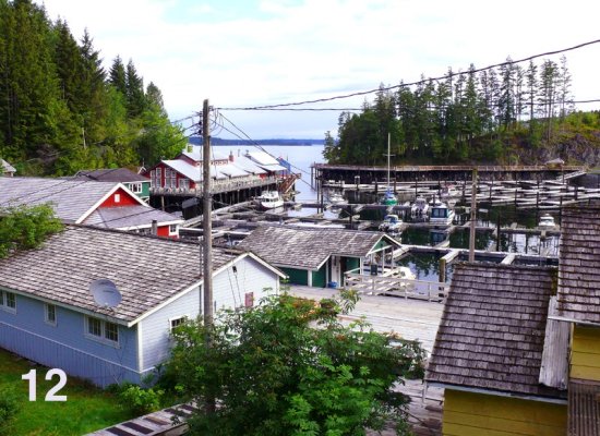
Okay, it's only fair that PNW boaters get the same opportunity. So here are fourteen photos I've taken on cruises over the past three years. Some bodies of water or locations should be pretty easy for people who've cruised these waters to identify, some maybe not so much.* I will tell you that they were all taken north of Bellingham and south of Port Hardy on Vancouver Island.* Whoever gets the most correct will get a free two week cruise on our new Fleming 55 when we get it from Hustler.
-- Edited by Marin on Saturday 15th of January 2011 04:05:54 PM
-- Edited by Marin on Saturday 15th of January 2011 04:05:54 PM
Attachments
-
 14.jpg116.3 KB · Views: 91
 -
 13.jpg114.6 KB · Views: 93
 -
 01.jpg157.2 KB · Views: 92
 -
 02.jpg78.1 KB · Views: 84
 -
 03.jpg117.8 KB · Views: 90
 -
 04.jpg52.5 KB · Views: 85
 -
 05.jpg117.8 KB · Views: 91
 -
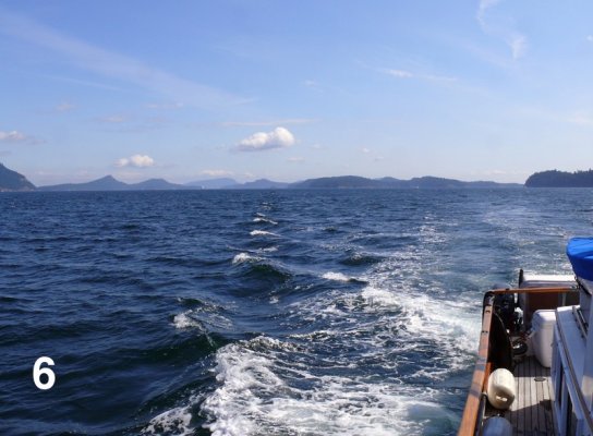 06.jpg121.9 KB · Views: 76
 -
 07.jpg160 KB · Views: 78
 -
 08.jpg94.9 KB · Views: 84
 -
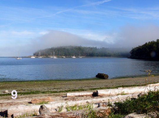 09.jpg129.3 KB · Views: 89
 -
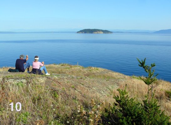 10.jpg155.2 KB · Views: 87
 -
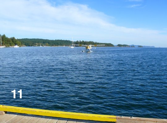 11.jpg136.7 KB · Views: 89
 -
 12.jpg197.4 KB · Views: 68
OP
OP
JohnP
Guru
- Joined
- Dec 13, 2009
- Messages
- 1,361
- Location
- USA
- Vessel Name
- V E N T U R E
- Vessel Make
- 1996 36' Island Gypsy Classic
I think*the NE one*was a lot easier. Most people got it. And the others figured out by process of elimination.
It is the Champlain Canal.
Marin's is pretty hard to answer.****But at least you will win a trip.* Also the images are quite beautiful.*
Don't think I could figure it out even if the prize was a 2011* 75'* Flemming.*
It is the Champlain Canal.
Marin's is pretty hard to answer.****But at least you will win a trip.* Also the images are quite beautiful.*
Don't think I could figure it out even if the prize was a 2011* 75'* Flemming.*
When I lived in Hawaii and was flying to different islands almost every weekend for some eight or nine years, I think a person could show me a photograph of any piece of coastline from any island and I could identify it. But even though we've flown up and down the Inside Passage many times and boated some of the more popular areas between Bellingham and Port McNeil, I suspect I could not identify the majority of photos people showed me of the coastline or bodies of water, partly because there's so much of it and partly because unless you are very familiar with a particular piece of terrain, it's hard to distinguish between one tree-covered island and another one. I've tried to use photos that had some distinguishing visual elements that people can key on, although there is one that, frankly, could be anywhere (7).
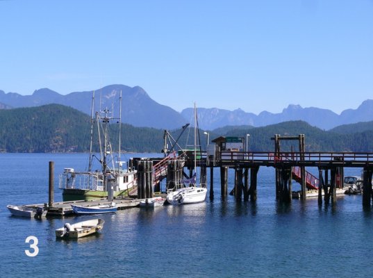
3 Squirrel Cove store (You can buy it, $1,350,000 as advertised in PY)
8 Grace Harbour
12 Telegraph Cove
8 Grace Harbour
12 Telegraph Cove
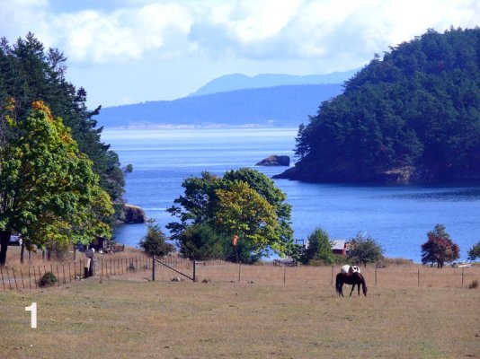
11 Ganges harbour
Conrad
Guru
- Joined
- Oct 19, 2007
- Messages
- 1,972
- Location
- Canada
- Vessel Name
- Blue Sky
- Vessel Make
- Nordic Tugs 42 Hull #001
Don't have any charts, so some references will be vague...2) Southern tip of San Juan IslandMarin wrote:
Okay, it's only fair that PNW boaters get the same opportunity. So here are fourteen photos I've taken on cruises over the past three years. Some bodies of water or locations should be pretty easy for people who've cruised these waters to identify, some maybe not so much.* I will tell you that they were all taken north of Bellingham and south of Port Hardy on Vancouver Island.* Whoever gets the most correct will get a free two week cruise on our new Fleming 55 when we get it from Hustler.
-- Edited by Marin on Saturday 15th of January 2011 04:05:54 PM
3) Squirrel Cove
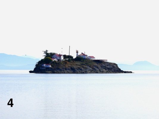
4) Chrome Island lighthouse
5) Channel between Hornby & Denman Islands
7) Channel just south of Refuge Cove
8) Grace Harbour
12) Telegraph Cove
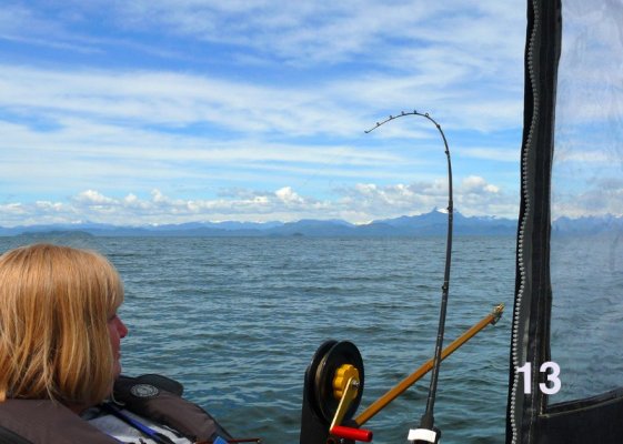
13) Georgia Strait looking west at Vancouver Island
14) Maple Bay
(Hopefully that will at least warrant a ride in the dinghy towed behind the Fleming!)
*
Nomad Willy
Guru
1. *Stuart Is2. *Waldron to port Orcas to stbd
3. *Squirrel Cove dock
4. *Entrance Is.
5. *Spring Passage
6. *Rosario Strait
7. *Peavine Passage
8. *Parks Bay
9. *Shoal Bay
10.Matia Is from Sucia Is.
11.Friday Hbr
12Telegraph Cove
13.Georgia Strait
14.Ganges
3. *Squirrel Cove dock
4. *Entrance Is.
5. *Spring Passage
6. *Rosario Strait
7. *Peavine Passage
8. *Parks Bay
9. *Shoal Bay
10.Matia Is from Sucia Is.
11.Friday Hbr
12Telegraph Cove
13.Georgia Strait
14.Ganges
Killick
Veteran Member
Ganges & Entrance Island are pretty easy.* As to the rest, well, there's a lot of seascape to choose from!* The coolest thing about the pics are that a friends boat (the Terry Wayne) is in number 14 - darned if I know where they were at the time though.* Great shots!
Edit......seems it's a whole lot easier to recognize boats than it is places!* I stand corrected and am looking forward to the results!* Could have sworn that that was Entrance Isl.
-- Edited by Killick on Saturday 15th of January 2011 07:35:17 PM
Edit......seems it's a whole lot easier to recognize boats than it is places!* I stand corrected and am looking forward to the results!* Could have sworn that that was Entrance Isl.
-- Edited by Killick on Saturday 15th of January 2011 07:35:17 PM
Nomad Willy
Guru
11. * Ganges
14. * Pender Hbr.
14. * Pender Hbr.
Moonstruck
Guru
- Joined
- Nov 27, 2008
- Messages
- 8,276
- Location
- USA
- Vessel Name
- Moonstruck
- Vessel Make
- Sabre 42 Hardtop Express
Eric, it must be bland up there.* They seem to all look alike.nomadwilly wrote:
11. * Ganges
14. * Pender Hbr.

*
Eric is right about 14, its Garden Bay, Pender Harbour, and the 1912 boat of a good friend shows at the RVYC dock, extreme left.
Don: Alike? In the eye of the beholder.
Bland? never!
Don: Alike? In the eye of the beholder.
Bland? never!
Moonstruck
Guru
- Joined
- Nov 27, 2008
- Messages
- 8,276
- Location
- USA
- Vessel Name
- Moonstruck
- Vessel Make
- Sabre 42 Hardtop Express
You obviously missed the "no" on the end.* As a matter of fact I am trying to put together a trip out there to rent a car at Seattle and take the ferry stystem up to Canada then drive back to the airport.* Any suggestions?* I mean about the trip.koliver wrote:
Eric is right about 14, its Garden Bay, Pender Harbour, and the 1912 boat of a good friend shows at the RVYC dock, extreme left.
Don: Alike? In the eye of the beholder.
Bland? never!

*
-- Edited by Moonstruck on Sunday 16th of January 2011 11:41:43 AM
Your ferry options for going to Canada from the US with a car total two. You can ride the Washington State Ferry from Anacortes through the San Juan Islands to Sidney, BC on Vancouver Island. Or you can ride the Black Ball ferry from Port Angeles on the Olympic Peninsula to Victoria across the Strait of Juan de Fuca. Once you're on Vancouver Island you have a couple of choices to get back in addition to riding the same boats the other way.
You can take a BC ferry from Sidney to Tawassen on the mainland just north of the US border. Or you can drive up the island to Nanaimo and take a BC ferry from Nanaimo to Tawassen (2 hrs) or from Nanaimo to Departure Bay north of Vancouver (city). These ferries depart from two different terminals in Nanaimo.
Any of these options other than just getting back on the boat you just got off of will most likely need a couple of days to do unless you want be riding ferries or driving pretty much all day and possibly part of that night.
Moonstruck
Guru
- Joined
- Nov 27, 2008
- Messages
- 8,276
- Location
- USA
- Vessel Name
- Moonstruck
- Vessel Make
- Sabre 42 Hardtop Express
Thanks Marin.* I thought 9 or 10 days to alot to the trip would do it.* The Washington State Ferry system is the one preferred.* Thought about stopping at a couple of islands then up to* Canada for about 3 nights.* How would September do for crowds and weather?Marin wrote:
Your ferry options for going to Canada from the US with a car total two. You can ride the Washington State Ferry from Anacortes through the San Juan Islands to Sidney, BC on Vancouver Island. Or you can ride the Black Ball ferry from Port Angeles on the Olympic Peninsula to Victoria across the Strait of Juan de Fuca. Once you're on Vancouver Island you have a couple of choices to get back in addition to riding the same boats the other way.
You can take a BC ferry from Sidney to Tawassen on the mainland just north of the US border. Or you can drive up the island to Nanaimo and take a BC ferry from Nanaimo to Tawassen (2 hrs) or from Nanaimo to Departure Bay north of Vancouver (city). These ferries depart from two different terminals in Nanaimo.
Any of these options other than just getting back on the boat you just got off of will most likely need a couple of days to do unless you want be riding ferries or driving pretty much all day and possibly part of that night.
*
September is one of the best boating months here. It's when we always take our longer (2-3 week) cruises. While you can get rain, hail, fog, screaming wind, volcanic ash and attacks by rabid orcas and river otters all year round, September can have a few days of really nice weather. Most of the photos I put up in this thread were taken in September.
In addition to a better-than-average chance of decent weather (if you consider sunny days to be decent weather) the truly great thing is that just about everyone except retirees and a few people taking vacations is back to work or school. So anchorages and ports that were squirming with boaters like maggots on a dead deer are sometimes completely empty, or if they're not, are WAY more enjoyable than they were during the previous two months. So even if you are doing your touring by car and ferry you will find the places like Orcas Island, San Juan Island, and the harbor towns of Victoria, Sidney, Nanaimo, Ganges--- even Vancouver itself--- much more pleasant and relaxing.
And all this applies to the roads as well. Traffic in Seattle itself is a disaster 24/7/365, but once vacations are over and school has started, driving and the places you can drive to are much more enjoyable.
PS--- Just my opinon, but I think BC, including Vancouver Island, is WAY more interesting and scenic and just plain neat to be in than Seattle and western Washington.* I didn't move to Seattle because of Seattle, I moved here in spite of Seattle.* Besides the job I have, the main draw to living here for me is it's proximitiy to BC.* So if I had 9 or !0 days starting in Seattle, I'd go see the San Juans and then go to Vancouver Island, muck about over there for a few days, drive to Nanaimo, take the ferry to Departure Bay outside of Vancouver, and then depending on what mood I was in drive up the Sunshine Coast or if I wanted to do the river-mountains-forest-sagebrush thing I'd drive Highway 1 up the Fraser and Thompson Rivers and on up into he Cariboo country or come back down via the Okanagan country in eastern Washington.* That's a lot of driving but my wife and I like to drive, so that's an attraction for us, not a detriment.* But if you would rather spend more time in fewer locations I'd still get out of Washington asap and get into the San Juan and Gulf Islands, explore around on Vancouver Island., and come back Vancouver itself which is a wonderful city to visit.* By comparison, Seattle is a wide spot in the road in the Dust Bowl.
-- Edited by Marin on Sunday 16th of January 2011 01:08:36 PM
Carey
Guru
- Joined
- Oct 5, 2007
- Messages
- 1,101
- Location
- USA
- Vessel Name
- Happy Destiny
- Vessel Make
- Custom Lobster Yacht
Thanks Marin.* I thought 9 or 10 days to alot to the trip would do it.* The Washington State Ferry system is the one preferred.* Thought about stopping at a couple of islands then up to* Canada for about 3 nights.* How would September do for crowds and weather?DonWhat Marin has said so far is correct. As to you visiting different San Juan Islands on the way to Sidney, I don't believe you can do that. You may have to go to Sidney, and then do your San Juan visitation by getting off in Friday Harbor, where you can clear customs, and then do your island hopping back to Anacortes.Moonstruck wroteMarin wrote:
Your ferry options for going to Canada from the US with a car total two. You can ride the Washington State Ferry from Anacortes through the San Juan Islands to Sidney, BC on Vancouver Island. Or you can ride the Black Ball ferry from Port Angeles on the Olympic Peninsula to Victoria across the Strait of Juan de Fuca. Once you're on Vancouver Island you have a couple of choices to get back in addition to riding the same boats the other way.
You can take a BC ferry from Sidney to Tawassen on the mainland just north of the US border. Or you can drive up the island to Nanaimo and take a BC ferry from Nanaimo to Tawassen (2 hrs) or from Nanaimo to Departure Bay north of Vancouver (city). These ferries depart from two different terminals in Nanaimo.
Any of these options other than just getting back on the boat you just got off of will most likely need a couple of days to do unless you want be riding ferries or driving pretty much all day and possibly part of that night.
Once on the island, given the time you have available, I would drive the east side of Vancouver Island north to Parksville, and then turn west accross the island to Uclulet and Tofino. Then go back to the east side and continue north to Campbell River, and depending on time, maybe go further north.
*
Actually, Carey's idea of spending the whole time in the San Juans, the Gulfs (at least Ganges anyway), and Vancovuer Island is probably the best. Particularly if you drive across the mountains from Port Alberni to Ucluelet, Tofino and the Pacific Rim National Park. Vancouver's mountains are every bit as big and dramatic as the ones on the mainland. And the north end of the island is neat, too. If you drive to Campbell River you can take a ferry across to Quadra Island which has some neat little communities and lots of little farms, artists, etc.
And if you're really ambitious you can drive to Port Hardy and then take the BC ferry up the Inside Passage to Prince Rupert. Then from Prince Rupert you can drive east to Prince George, and then south on 97 and Highway 1 back to Vancouver along the Thompson and Fraser Rivers. You'd need a wee bit more than 9 days though, unless you were Jeremy Clarkson and did the drive in an Aston Martin DB9.
And if you're really ambitious you can drive to Port Hardy and then take the BC ferry up the Inside Passage to Prince Rupert. Then from Prince Rupert you can drive east to Prince George, and then south on 97 and Highway 1 back to Vancouver along the Thompson and Fraser Rivers. You'd need a wee bit more than 9 days though, unless you were Jeremy Clarkson and did the drive in an Aston Martin DB9.
markpierce
Master and Commander
- Joined
- Sep 25, 2010
- Messages
- 12,557
- Location
- USA
- Vessel Name
- Carquinez Coot
- Vessel Make
- penultimate Seahorse Marine Coot hull #6
Speaking of ferries ...
This period photo contains prominent*landmark-clues as to its precise west-coast location.

This period photo contains prominent*landmark-clues as to its precise west-coast location.
Nomad Willy
Guru
Actually Moon may find much more of interest in Vancouver than the Gulf Is or San Juan Is. Vancouver is such a wonderful international city it would be a shame to miss it for looking at boating places. Obviously time to do both would be far best.*Marin,
Am I right about Ganges?
Am I right about Ganges?
Moonstruck
Guru
- Joined
- Nov 27, 2008
- Messages
- 8,276
- Location
- USA
- Vessel Name
- Moonstruck
- Vessel Make
- Sabre 42 Hardtop Express
Eric, Vancouver is definitely on the list to do.* There is no schedule, and a couple of days one way or the other will not hurt.* Just trying to put it together.
Oakland, with Yerba Buena Island in the background?markpierce wrote:
Speaking of ferries ...
This period photo contains prominent*landmark-clues as to its precise west-coast location.
*
Carey
Guru
- Joined
- Oct 5, 2007
- Messages
- 1,101
- Location
- USA
- Vessel Name
- Happy Destiny
- Vessel Make
- Custom Lobster Yacht
DonAn afternoon and evening in Victoria would be good. One of our favorite things is to tie up right in front of the Empress Hotel, in Victoria's inner harbor. Street entertainers surround you, and the ambience is incredible. Feels like an old world English city. Check out the art gallery in the Empress.
Similar threads
- Replies
- 31
- Views
- 3K