Using Your AP on Routes

The friendliest place on the web for anyone who enjoys boating.
If you have answers, please help by responding to the unanswered posts.
It just seems to me that your AP making a turn at a waypoint should never be a surprise. If it is, you aren't keeping an adequate watch.


And if something other than the planned turn is required, you should have already taken control via Auto mode or manual steering before the pilot would have made the turn on it's own. Otherwise you aren't keeping an adequate watch.


Otherwise, let the pilot make the turn, and watch to see how good a job it does of carrying out the turn, and exiting on track, and on heading. If it misses, you have some tuning to do.
 
Feet on the dash! Who would (note remote to left of console) do that?


Traveling to Coecles Harbor Shelter Island, Long Island NY last weekend.


Rob


Rob, that is almost exactly the way I look most of the time at the helm. I will often have the wireless remote in my hand so I don’t have to stretch to reach the AP remote.

Your dash is a lot neater than mine however. Mine is covered with charts, charging cords, bits and bobs etc....
 
It just seems to me that your AP making a turn at a waypoint should never be a surprise. If it is, you aren't keeping an adequate watch.


I totally agree with you, twisted tree, about keeping adequate watch. But I should clarify my previous point, because there was something, in particular, I was thinking of, but did not actually write. That something is this: When running a route that involves waypoints near buoys, I want to be alerted to the precise point at which the AP intends to turn (i.e. via mandatory confirmation alert). This is the case for a number of reasons: 1) Buoys can move a bit from exact charted location because of waves/wind/current, 2) Buoys can move a LOT because of some failure with the fixing at the bottom, 3) in plotting the route, I may have placed a waypoint unnecessarily and inappropriately close to a buoy. As such, I want to step up my normal lookout to be ready to grab the helm if the AP decides it wants to turn directly toward a buoy. For this, I personally find the turn confirmation alert helpful.


I still have something to work on with my AP. When letting it make the turn (which is what I normally do), I notice that it often seems to "oversteer" a bit and then it has to set about correcting itself. I am hoping that when I dive into the AP setup configuration someday, I will find a way to adjust this.
 
I totally agree with you, twisted tree, about keeping adequate watch. But I should clarify my previous point, because there was something, in particular, I was thinking of, but did not actually write. That something is this: When running a route that involves waypoints near buoys, I want to be alerted to the precise point at which the AP intends to turn (i.e. via mandatory confirmation alert). This is the case for a number of reasons: 1) Buoys can move a bit from exact charted location because of waves/wind/current, 2) Buoys can move a LOT because of some failure with the fixing at the bottom, 3) in plotting the route, I may have placed a waypoint unnecessarily and inappropriately close to a buoy. As such, I want to step up my normal lookout to be ready to grab the helm if the AP decides it wants to turn directly toward a buoy. For this, I personally find the turn confirmation alert helpful.


I still have something to work on with my AP. When letting it make the turn (which is what I normally do), I notice that it often seems to "oversteer" a bit and then it has to set about correcting itself. I am hoping that when I dive into the AP setup configuration someday, I will find a way to adjust this.


Got it. I'm curious, do your route lines and waypoints display on your chart plotter? Mine do (CoastalExplorer) so it's always clear how far away you are from the turn, etc. But if the turn is in any way close to obstacles, buoys, etc., I take control in advance and make the turn myself, or even just move the waypoint, or skip ahead to the next waypoint and turn early. But I suppose if you are attentive, it really doesn't matter too much whether the default for the AP is to turn, or wait for your OK the turn. Either way, you are supervising the turn.


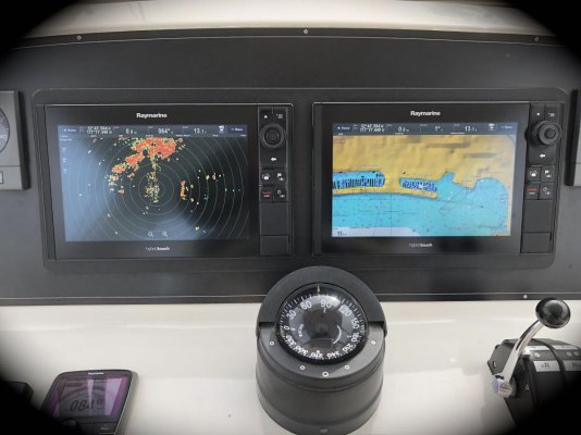
Speaking of route lines and waypoints, my active waypoint also shows up on the radar (separate radar screen, not overlaid on a chart). That helps place the turn point in context with your actual surroundings, should visibility be reduced, markers moved, or distances uncertain.


And speaking of moving waypoints, someone else brought this up earlier. I move them all the time while the route is active, tuning and adjusting the route to suit circumstances. So it's a very dynamic process, depending on where you are operating. You just need to be careful changing the active waypoint because it will create a sudden change in XTE and heading to waypoint, and can really send the boat off in another direction. "Reset XTE" is your friend in this case, and resets XTE based on the new route line. Our process is the 1) switch to auto, 2) move the waypoint, 3) dial the auto heading towards the new waypoint location, 4) Reset XTE, 5) Resume Nav mode.


Yes, my route lines and waypoints show up on my Raymarine e127 chart plotter. And yes, "close" is relative. There are, of course, many times where it's just too close to trust anything but human hands on the wheel making the maneuver.


Good point on the radar. I suspect my waypoint would show up on the radar-only screen. I will have to try it some time. I primarily use my radar in chart-overlay mode. I have, thus far, been fortunate enough to not get caught in such unfavorable circumstances that I need to go to the radar screen-only mode.


I find that skipping waypoints on my Raymarine plotter is easy. Moving the waypoints and editing the route, while underway, however, is tedious. Perhaps it's the software and perhaps, there are aspects of this technique I have yet to learn. Reset XTE is, indeed, my very good friend ;-)

PC chart plotters make adjusting routes and waypoints easy.

I correct routes and make changes to suit circumstances while underway and after arriving at my destination.
 
Yes, my route lines and waypoints show up on my Raymarine e127 chart plotter.

Good point on the radar. I suspect my waypoint would show up on the radar-only screen. (It does!)

I find that skipping waypoints on my Raymarine plotter is easy. Reset XTE is, indeed, my very good friend ;-)
I also have an eS 127 & an eS 128 with an Evolution AP which is utterly fantastic! Although I know many ways to use them, I certainly don't know all the various advantages they can deliver.
 

Attachments

  • eS 127 & eS 128.jpg
    eS 127 & eS 128.jpg
    105.4 KB · Views: 12
Raymarine does put waypoints on the radar. Route lines are also shown on the plotter. You get a solid line for the route with the active segment being a dotted line.

I feel the argument between the AP auto changing turn points vs manually approving the turn is a “6 one way 1/2 a dozen the other” type discussion. In both cases lack of human attentiveness could result in a disaster.
 
Back
Top Bottom