You are using an out of date browser. It may not display this or other websites correctly.
You should upgrade or use an alternative browser.
You should upgrade or use an alternative browser.
Transiting to & from Desolation Sound
- Thread starter RedRascal
- Start date
The friendliest place on the web for anyone who enjoys boating.
If you have answers, please help by responding to the unanswered posts.
If you have answers, please help by responding to the unanswered posts.
Kawini
Senior Member
I’ve chartered from Cooper at both their Sidney and Powell River bases. Extremely friendly and helpful people. Larry - manager of Cooper’s base in PR - was great last year as we prepared for our cruise to Princess Louisa and Desolation Sound.
A satisfied Cooper customer-
Steve Sugarman
A satisfied Cooper customer-
Steve Sugarman
rsn48
Guru
- Joined
- Feb 18, 2019
- Messages
- 2,019
- Location
- Canada
- Vessel Name
- Capricorn
- Vessel Make
- Mariner 30 - Sedan Cruiser 1969
Red Rascal
So, how are you going to get to Powell River? On a tight schedule basis getting to and from your charter point is an adventure in itself.
I would suggest local knowledge is golden, there are two ways you can get to Powell River, kind of like how the people from Powell River get to Vancouver.
Method one, the slower way:
Take the ferry from Horseshoe Bay to Nanaimo, then up to Comox and take that ferry to Powell River. I only include this for others who might want to do a similar trip and want to see something of Vancouver Island. Or you could overnight in Victoria (see the town) then motor up to Comox.
Method Two, what the Powell River locals do - but what do they know?
Take the ferry from Horseshoe Bay to Langdale (think of it as Gibsons), this is a short ferry by BC standards, roughly half an hour, too lazy to look. Then the next ferry further up from Earls Cove to Saltery Bay.
I link the Google map illustration of both. The slow route according to Google is 5 hours is 5 hours 11 minutes and the faster way is 4 hours 8 minutes.
https://www.google.com/maps/dir/Hor...938b58623!2m2!1d-124.5247061!2d49.8352352!3e0
I have only run into Americans who are nervous about the Strait of Georgia. I guess it is that for most of us living along the coast, eg Vancouver, Victoria, Nanaimo, Courtney/Comox, Powell River, et. al. we see it constantly, some of us every day so we know that most the time the Strait is relatively placid. In the summer, sailboaters are cursing it as the wind is famous for not showing up, coming in too lightly, or disappearing later in the afternoon (some say this is intentional so a cocktail hour can be observed without disturbance).
Based on comments worried about risk, here are some none charter boat related risks:
1. You vehicle could explode with that dangerous gas tank.
2. You could have a collision in your vehicle that is some one else's fault and die.
3. The ferry you are on could break down and you are stranded on the water for many hours (this has happened more than once).
4. You could arrive at the ferry without reservations and discover the line up is so long you won't be able to get on till the next day.
5. You could get caught in Vancouver traffic and there goes the schedule. [Take the truck crossing at Blaine and take the road going straight to the highway and follow it in. You can still run into irritating congestion, but less so than driving through Vancouver].
I say all this in half jest, its my way to say, don't over think your trip, a lot could go wrong, but based on probability, you'll have a happy incident free trip. Just get out there and do it. Or as Martin Luther once said: "Sin boldly, young man!"
NorWyn
Veteran Member
....Alternatively fly into Powell river on a regularly scheduled flight and take a cab to pick up your charter....flight is about $150 per person from YVR ( vancouver)
We did this with our Michigan friend last May and it worked really well. Again, in May lots of stops were closed.
We picked him up at the fuel dock in Powell River and headed north for an awesome ten day trip in Desolation. Dropped him In Campbell River and then continued for another 13 plus days in the Broughtons....but that is another tale.
We worked around the water and provisions issues and all was well. Our trip in September 2018 paid dividends in terms of knowing what to expect. As with spring 2019 September 2018 showed us that lots of services were limited or outright closed but there are work arounds.....
-Chris
OP
OP
RedRascal
Senior Member
Found out the second CHB 34 in Powell River, Amber Spirit, is no longer in the charter biz so back to doing a charter from the Vancouver Island side. I've been watching weather conditions via Sentry Shoal buoy and it doesn't seem too bad with a wind around 15 knots. That seems to generate about 1/2 meter seas when it's blowing 15. Also seems like it takes about 2-3 hours to build from an 1/2 meter to a meter+ with winds getting into the low 20s. 15 knots of wind seems really doable in CHB 34 so it's making me feel better about crossing the strait with some comfort. Since a CHB 34 is potential a boat we would consider for purchase I don't want it flat calm the whole time. It would be good to see how life is aboard when it's blowing 15-20 and the same goes for life aboard in the rain. More weather to study...
OP
OP
RedRascal
Senior Member
I’ve chartered from Cooper at both their Sidney and Powell River bases. Extremely friendly and helpful people. Larry - manager of Cooper’s base in PR - was great last year as we prepared for our cruise to Princess Louisa and Desolation Sound.
Cooper does seem like a good outfit to work with, they been friendly and helpful on the phone.
firehoser75
Guru
- Joined
- Feb 18, 2018
- Messages
- 1,706
- Location
- Canada
- Vessel Name
- former owner of "Pilitak"
- Vessel Make
- Nordic Tug 37
Cooper are a great outfit. I had my first boat, a sailboat in their fleet for one summer. However, being a charter owner was not for me...... too anal about my boat.
Crossing is very doable in a CHB 34 I am sure, just remember, if wind is predicted, AVOID wind over tide. That can cause the waves to pile up, become short, steep, and confused. In other words, no fun, and it is supposed to be "pleasure boating".")
Enjoy your trip...
Crossing is very doable in a CHB 34 I am sure, just remember, if wind is predicted, AVOID wind over tide. That can cause the waves to pile up, become short, steep, and confused. In other words, no fun, and it is supposed to be "pleasure boating".
Enjoy your trip...
We've chartered from Cooper for the past five years. Great people, the boats are well maintained. They have a GB 36, "Mistral" out of Sydney that we will charter this September. I have been all over that boat and she is certainly one to charter. Perhaps they can move this to Powell River for you. The only challenge is to get to Powell River (at least for us) we flew in, it's a bit pricey, I understand that you can get there by car but I have found no public (bus) transportation up there.
Enjoy Desolation, it should be pretty in April but crowded in July/August. The Gulf Islands are great as well if you are coming out of Sydney
Enjoy Desolation, it should be pretty in April but crowded in July/August. The Gulf Islands are great as well if you are coming out of Sydney
Slider70
Senior Member
One of the major rules I try to live by in my 56 years of travel on these waters is to not restrict myself to a rigid schedule. With the short fixed time you have I would not consider chartering from Comox, rather do it from Powell River, at that time of year.
Obviously the weather can be grand then but much more common to be challenging. Going from Powell River the only major weather concern is between Westview and Lund. We did lose one of our commercial fishermen half way between with a nasty SE and the wrong tide. Boat rolled over. Two dead.
Not trying to scare you but tight schedules and water travel are a bad combination any time of the year but in April more so.
rcsomany
Veteran Member
- Joined
- Jul 7, 2019
- Messages
- 52
- Location
- Canada
- Vessel Name
- Gypsy Cloud
- Vessel Make
- Pacific Trawler 40
Outflow Winds
(Cooper's CHB 35 in Powell River looks booked for almost all of April but appears to have an opening right at the end of the month.)
Good luck.
In August (!) 2016, I got caught by an outflow wind in Homfray Channel (south from Bute and Toba). Ran away from it to Homfray Lodge but it was much more than uncomfortable - downright scary. Wave action at the Lodge's dock forced us ashore for the night.As far as weather goes...
... Always watch for outflow winds from Bute and Toba. .
Chartering on the Vancouver Island side for a trip to Desolation can chew up a day each way just to get there and back. Weather in Georgia Strait can trap you on one side or the other for days at a time - or tempt you to do something rash.Cooper boating charters out of Powell River. Don't have to cross the Strait of Georgia if that is your major concern.
(Cooper's CHB 35 in Powell River looks booked for almost all of April but appears to have an opening right at the end of the month.)
Good luck.
Pcpete
Senior Member
Beam seas and comfort are also dependent on the frequency. If they are more like rollers, 7-10 seconds, that’s a whole bunch different from a five second frequency. In any case, you are going to want to “rig for silent running”. Having wave action empty the canned goods or dishware out of a locker is very disturbing. It’s been a while since I was at Refuge Cove, but when I was there last the water was not potable.
The Waggoners guide is excellent and updated annually. You’ll also want a good tide and current book. You might as well try to time your cruising time so the current is with you and giving you a higher over the ground speed instead of going into the current and go 7.5kn through the water and be doing 4kn over the ground.
The Waggoners guide is excellent and updated annually. You’ll also want a good tide and current book. You might as well try to time your cruising time so the current is with you and giving you a higher over the ground speed instead of going into the current and go 7.5kn through the water and be doing 4kn over the ground.
firehoser75
Guru
- Joined
- Feb 18, 2018
- Messages
- 1,706
- Location
- Canada
- Vessel Name
- former owner of "Pilitak"
- Vessel Make
- Nordic Tug 37
PcPete,
I can't say for sure concerning the "off Season" (April), but the water at Refuge has been potable for quite a few years now. They filter and treat it. I know the owner's as we have spent quite a bit of time there over the years including early in the season prior to the "official opening"(early June), and they assure me that the water is excellent and tested regularly. I am fussy about what goes into my tank, and have been happy using their water for refilling my tank, and I drink my tank water.
Good point about SOG, but I don't enjoy beam seas, and try to avoid or at least minimize by altering course as needed.
Pcpete
Senior Member
Glad to hear the water at Refuge Cove is potable. Last summer was the first time I got the Admiral north of Nanimo. Our 2019 annual Commodores Cruise destination was Princess Louisa and I finally got to show her the spectacular cruising up there. We had over 25 boats from our club on this trip and at one point had 24 at the dock. Now she understands why I want to take her to the Broughtens.
OP
OP
RedRascal
Senior Member
Boy a lot has changed since I started this thread. This was suppose to be the week of our trip and I can only do it virtually at this point. Of course the weather forecast is calling for sunny skies most of the week and warm temperatures. Today we would have arrived at the charter boat, did a check out and loaded provisions in preparations for an AM departure Tuesday from Comox, British Columbia.
The weather report shows 15-25 NW winds tonight and tomorrow so I am not convinced we would be able to leave tomorrow as planned. Seems like a call we'd have to make at day break if we were to go or not. Question, if the winds were hanging around 15 and seas would allow running a comfort heading to either Harwood Island or Savary Island which would you do knowing wind and seas would build later in the day? My non-local knowledge guess would be to head towards the lee of Savary Island, at some point Savary would provide protection from the seas. Once to Savary we'd cut over towards Lund or if really nasty anchor in the lee of Savary and call it good.
Someday I will do this in real life but for now it's just a planning exercise.
Boy a lot has changed since I started this thread. This was suppose to be the week of our trip and I can only do it virtually at this point. Of course the weather forecast is calling for sunny skies most of the week and warm temperatures. Today we would have arrived at the charter boat, did a check out and loaded provisions in preparations for an AM departure Tuesday from Comox, British Columbia.
The weather report shows 15-25 NW winds tonight and tomorrow so I am not convinced we would be able to leave tomorrow as planned. Seems like a call we'd have to make at day break if we were to go or not. Question, if the winds were hanging around 15 and seas would allow running a comfort heading to either Harwood Island or Savary Island which would you do knowing wind and seas would build later in the day? My non-local knowledge guess would be to head towards the lee of Savary Island, at some point Savary would provide protection from the seas. Once to Savary we'd cut over towards Lund or if really nasty anchor in the lee of Savary and call it good.
Someday I will do this in real life but for now it's just a planning exercise.
Windy shows a maximum wind speed of 14 knots tomorrow afternoon, so no seas built up overnight and a good, easy morning crossing tomorrow before the wind has much chance to build a decent sea. As it is a NW wind, the fetch is short, so the sea won't build much over 1m. Might need your wipers, and you might need to put in a few 15° course changes to eliminate the rolling, but it is a short distance across to the shelter of Savary, then a quiet run into the short seas, if any, to Lund, or into Desolation.
Happy dreaming, and thanks for having us along.
rsn48
Guru
- Joined
- Feb 18, 2019
- Messages
- 2,019
- Location
- Canada
- Vessel Name
- Capricorn
- Vessel Make
- Mariner 30 - Sedan Cruiser 1969
Maybe if you do come up sometime you could stop at French Creek and we could have a lunch or dinner, good food but great food... lol. And if I am on the water meet up somewhere further in the direction of Desolation. One of my favourite marina's to go to is on Texada Island at the north end. The Texada Boat Club has visitors slips and moorage available and the price isn't stupid like some places. And a place on Texada to eat, again good food but not great food.
firehoser75
Guru
- Joined
- Feb 18, 2018
- Messages
- 1,706
- Location
- Canada
- Vessel Name
- former owner of "Pilitak"
- Vessel Make
- Nordic Tug 37
It is good to go through this as a "what if" exercise this year. You will be better prepared for the future. Just to file away, Savary is not a great anchorage unless the weather is predicted to be very calm. You would be much better off in Lund, or going further north through the Copeland Islands. Thulin Passage is very protected and it is only a short distance from Savary to the Copelands, and from the north end of Thulin into Desolation is also short. Obviously, all of that does depend on sea state. If rough, stay in Lund.
OP
OP
RedRascal
Senior Member
Oh boy this would have been a fantastic week to be in Desolation sound. For the rest of the world that is tuned into this thread it very likely could have been cold and rainy there this week. This week is forecasted to be sunny and actually kind of warm.
This morning winds were less than 15 and seas less than 1/2 a meter so I definitely would have left at sunrise. Pretty sure we would have headed for refuge cove for tonight. What I am gathering from you guys is heading for Savary would a reasonable heading for NW wind conditions. Once to Savary the fetch isn't enough to make it too nasty to get over to Lund with 15-25 knot winds. It can totally see how Thulin Passage could offer a lot of protection.
Local knowledge is king, thank you. At some point I am looking forward to using it.
RSN48 - That would be awesome to meet up, once we beat this pesky virus down I'll be working plans to make this trip happen.
SteveK
Guru
- Joined
- Jul 5, 2019
- Messages
- 5,077
- Location
- Gulf Isalnds BC canada
- Vessel Name
- Sea Sanctuary
- Vessel Make
- Bayliner 4588
Maybe if you do come up sometime you could stop at French Creek and we could have a lunch or dinner, good food but great food... lol. And if I am on the water meet up somewhere further in the direction of Desolation. One of my favourite marina's to go to is on Texada Island at the north end. The Texada Boat Club has visitors slips and moorage available and the price isn't stupid like some places. And a place on Texada to eat, again good food but not great food.
I will keep Texada in mind. Planned to go there to see some friends anyway
But from Comox coming across to Texade east side is almost a detour to Desolation, is it not.
Redrascal,
To make you feel better, maybe, we are cut off from our boat due to essential travel restrictions. My week on board is now delayed too.
Northern Spy
Guru
- Joined
- Feb 5, 2012
- Messages
- 4,075
- Location
- Canada
- Vessel Name
- Northern Spy
- Vessel Make
- Nordic Tug 26
It was a lumpy NW wind out there for much of the day. But a NW wind here means sunny for a week. Last night it was dead calm though.
It would have been a beautiful spring week up in Desolation this week.
I'm stuck working at home... [emoji853]
It would have been a beautiful spring week up in Desolation this week.
I'm stuck working at home... [emoji853]
Northern Spy
Guru
- Joined
- Feb 5, 2012
- Messages
- 4,075
- Location
- Canada
- Vessel Name
- Northern Spy
- Vessel Make
- Nordic Tug 26
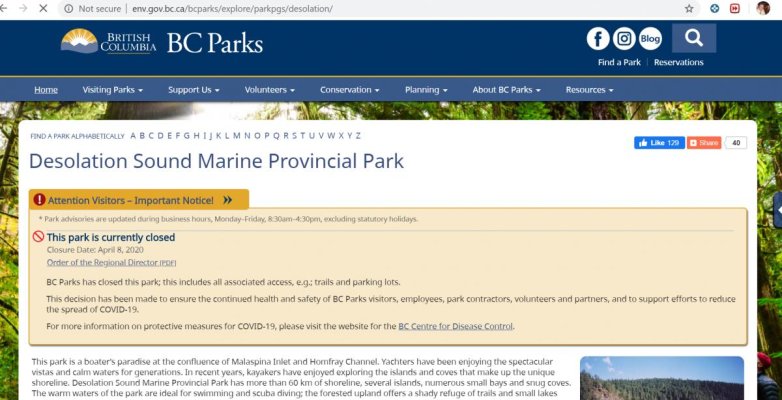
They just shut all the Provincial Parks. All the best anchorages...sigh.
Up until now, I thought the BC government as being fairly reasonable with their requests and closures. Sigh, indeed.
SteveK
Guru
- Joined
- Jul 5, 2019
- Messages
- 5,077
- Location
- Gulf Isalnds BC canada
- Vessel Name
- Sea Sanctuary
- Vessel Make
- Bayliner 4588
I give up searching for this, their website, their twitter site do not say this.They just shut all the Provincial Parks. All the best anchorages...sigh.
Land marine park access is closed and no facility service. nothing about anchorages.
Please provide a link
Northern Spy
Guru
- Joined
- Feb 5, 2012
- Messages
- 4,075
- Location
- Canada
- Vessel Name
- Northern Spy
- Vessel Make
- Nordic Tug 26
I give up searching for this, their website, their twitter site do not say this.
Land marine park access is closed and no facility service. nothing about anchorages.
Please provide a link
https://news.gov.bc.ca/releases/2020ENV0019-000645
or go to any park page, allow it to load and this banner will come up...
Attachments

Last edited:
SteveK
Guru
- Joined
- Jul 5, 2019
- Messages
- 5,077
- Location
- Gulf Isalnds BC canada
- Vessel Name
- Sea Sanctuary
- Vessel Make
- Bayliner 4588
I know land access is closed, it says nothing about boat access or anchorage
Northern Spy
Guru
- Joined
- Feb 5, 2012
- Messages
- 4,075
- Location
- Canada
- Vessel Name
- Northern Spy
- Vessel Make
- Nordic Tug 26
I know land access is closed, it says nothing about boat access or anchorage
Park boundary is on a water lot too.
SteveK
Guru
- Joined
- Jul 5, 2019
- Messages
- 5,077
- Location
- Gulf Isalnds BC canada
- Vessel Name
- Sea Sanctuary
- Vessel Make
- Bayliner 4588
Did you notice how specific they are about no cars, no camping. Stanley park is closed to cars so bikes stay on roads and leave pedestrians on walkways.Park boundary is on a water lot too.
When you find a link that says no anchoring in marine parks, post it.
Northern Spy
Guru
- Joined
- Feb 5, 2012
- Messages
- 4,075
- Location
- Canada
- Vessel Name
- Northern Spy
- Vessel Make
- Nordic Tug 26
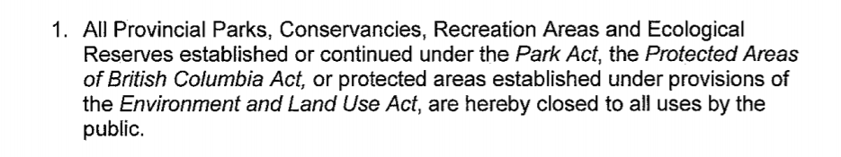
All seems to be the encompassing word. Here is directive:
http://bcparks.ca/advisories/2020/o...ectors-Order-Full-Closure.pdf?v=1586373591398
http://bcparks.ca/advisories/2020/o...ectors-Order-Full-Closure.pdf?v=1586373591398
Attachments
Last edited:
Northern Spy
Guru
- Joined
- Feb 5, 2012
- Messages
- 4,075
- Location
- Canada
- Vessel Name
- Northern Spy
- Vessel Make
- Nordic Tug 26
Redrascal,
A webcam for you from Powell River looking towards Comox, well actually, Texada.
https://www.prpeak.com/webcam
A webcam for you from Powell River looking towards Comox, well actually, Texada.
https://www.prpeak.com/webcam
Northern Spy
Guru
- Joined
- Feb 5, 2012
- Messages
- 4,075
- Location
- Canada
- Vessel Name
- Northern Spy
- Vessel Make
- Nordic Tug 26
Incredible weather. 
Similar threads
- Replies
- 33
- Views
- 2K
- Replies
- 4
- Views
- 504