Tides

The friendliest place on the web for anyone who enjoys boating.
If you have answers, please help by responding to the unanswered posts.

timjet

Guru
Joined
Apr 9, 2009
Messages
1,920
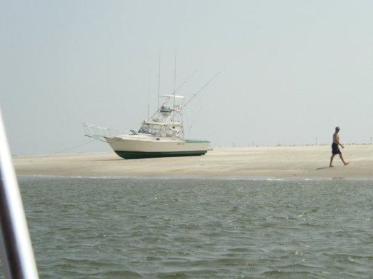
Having been a sail-boater and cruising the SW Florida area with our shallow water and narrow channels, I probably should be an expert on tide prediction. However I'm not and I found the few times I did run aground to be pretty non-eventful. With practice it's pretty easy to get a sailboat off a soft bottom without any help. The mast makes a good lever to tilt the boat, something not available to us mast-less motor boaters.

So before I get into trouble, I thought it would be a good idea to brush up on the use of the tide tables. But I got to thinking, with all the phone apps and many GPS's with tide tables installed does anybody ever use the tide tables anymore?

So what apps do you guys use for your iphone and androids? And can these apps give tide heights at your specific location without interpolation? Can you specify a lat/long and get tides or better yet can you slew the cursor to a point and get tide info at that point?
 
There is a tide program that has been around for a long time for PCs (don't know if it runs on Macs). It gives the tide tables for every tide reporting station in the US in chart form and in data form. I have it on my computer at work but not here at home. This program came out a long time ago and I suspect there have been many more created since then. A quick Google search showed a whole bunch of stuff but I didn't examine any of them.

For our own waters I use a research tool put together by the University of Washington. It shows the tides, winds, currents, etc. for about three or four days in advance. You can pick the day and the time and it will show on a chart what the currents, winds, tides will be doing in Puget Sound at that particular time.

With 8 to 20 foot tides in the PNW, BC, and SE Alaska along with tidal currents up to 15 knots, we are all very tide and current conscious out here
smile.gif
 
That's the one I was talking about, WXTide32.* Thanks for posting the name.


-- Edited by Marin on Sunday 19th of September 2010 01:52:44 PM
 
It doesn't seem to allow you to put in your own lat/long for tide predictions. So my question is how do I find the tide predictions at a point not in the data base?
 
I'm not sure I've seen a program that you are able to input a specific location (longitude & latitude) and get the tides.* WXTide32 allows you to put in a longitude and latitude but it will only give you the closest tide station if I remember right.**

When we cruised Alaska and the PNW we used Reeds Almanac.* It gave predicted current information for select locations such as narrows and passes.** This for us was more important than tides in some cases.* As Marin mentioned with occasion tide ranges greater than*15 feet, it means a look of water is moving.* We have been in some areas that the current created by tides is over 7 knots.* And high or low tide doesn't mean slack water.

Larry/Lena
Hobo KK42
La Paz, BCS, MX
 
timjet wrote:

It doesn't seem to allow you to put in your own lat/long for tide predictions. So my question is how do I find the tide predictions at a point not in the data base?
The short answer is, you can't.* The longer answer is that for some locations that do not have their own tide reporting stations they will often publish a time correction to a nearby tide station location.* For example, you will read something like "Acme Bay (add 20 minutes to Mud Bay tide times").* But I've never seen tidal data available by lat/long although I suppose it would be possible to do but the data base would be massive.

Everyone I know simply takes the tide information from the nearest reporting point and uses that.* The differences between the tide over here and the tide over there three miles away or five mies away or whatever isn't going to be different enough to matter.

*
 
I use "Ayetides" and "Navionics" on both an iPhone and an iPad. There are plenty of measured and calculated tide and current points to choose from with these programs. Works great!

Ray
 
we use sal****ertides.com
johnma
 
try it again salt water tides
(one word)
john
 
Thanks guys. Marin explained it very well. I thought it was mathematically possible to determine tides at any location, but with the variation in depths, land masses and such, I guess that would not be possible. My android phone has an app that will find the nearest reporting station and display tide predictions at that point, and my raymarine RL 80 has a data base as well and as soon as I get the GPS function of that fixed, I'll be good to go.

For you folks that have the Raymarine multi functional display (I think someone mentioned it hear) with the older raystar 120 GPS units like me that have a history of early failure, Raymarine is offering an upgrade at a reduced price. Just thought I'd let you know.

-- Edited by timjet on Monday 20th of September 2010 05:17:48 AM
 
I still use Tide Tables, and I also use the tides application on "The CAP'N".* For quick and dirty tidal info on the Tampa Area, you can go to http://www.thiswaytothe.net/tides/florida-tides-list.shtml.* This has representative locations besides whats in the tables, and is helpful for a quick look at the passes (I'm out of St Pete Beach) before I head out.* Still haven't graduated to 21st century technology like Droids, however with the variation in tides*from pass to pass*in Florida, using the values at a reporting station is worthless.
Glenn
M/V Syren
Jefferson 46
 
jleonard wrote:

I just use my Garmin.
Same here if I'm on my boat.* I have Garmin's "HomePort" software on my PCs so I can look up current or future tides withit.

Or, there are several Internet sites with tide predictions.

*
 
Marin,
Your'e scarin folks again. Basically we only have tides over 2 knots in narrow channels called "tidal rapids". There are a number of violent rapids like Ford's Terror, Nakwakto Rapids and Seymour Narrows that can flow 15 knots and they only have a few minutes of slack water during tide changes but most all rapids are below 7 knots max and most tides are of far less volume than spring tides. On the coast I only rarely need to alter plans to deal w tidal current.


I use tide tables and the Garmin plotter.
 
It is possible to calculate the height of the tide and the time at any given place providing you have a depth sounding (LAT sounding) on a chart.
Although I haven't had to do this for some time it is used for landing barges specifically when unloading or loading where you need to work the tides to get on and off the beach to maximise loading / unloading time.

Allan
 
Second biggest tides in the world it go's out for miles.

This is a shot of a bore tide coming into the Turnagain arm off Cook inlet.

Nuts on surf boards in dry suits actually ride this thing.
Not often but I have seen them doing so.

Dangerous. Mostly because of the Glacial silt it is like quick sand.

SD

-- Edited by skipperdude on Thursday 23rd of September 2010 03:47:49 PM
 

Attachments

  • img_0219.jpg
    img_0219.jpg
    194.6 KB · Views: 86
AllanY wrote:

It is possible to calculate the height of the tide and the time at any given place providing you have a depth sounding (LAT sounding) on a chart.
Although I haven't had to do this for some time it is used for landing barges specifically when unloading or loading where you need to work the tides to get on and off the beach to maximise loading / unloading time.

Allan
Well maybe a refresher course is in order for me.
The closest tide prediction station from me is about a mile away, pretty close really. So I use that location for determining the tide at my location by adding the tide height at the prediction station to the depth on the chart at by location to determine the depth of water at my location. Sound right?


Since the location of the prediction station is a mile away, the depth I derived at my location is only a approximation. Not only is the depth an approximation so would be the time.


So how do you determine the depth at a point located some distance from the prediction station?
 
nomadwilly wrote:

*
Marin,
Your'e scarin folks again. Basically we only have tides over 2 knots in narrow channels called "tidal rapids". There are a number of violent rapids like Ford's Terror, Nakwakto Rapids and Seymour Narrows that can flow 15 knots and they only have a few minutes of slack water during tide changes but most all rapids are below 7 knots max and most tides are of far less volume than spring tides. On the coast I only rarely need to alter plans to deal w tidal current.


I use tide tables and the Garmin plotter.
Haha, we get pretty rapid tides I'm guessin' 4-5 knots in a place called Snow's Cut, where they cut a channel between a big river and the ICW.** Otherwise around inlets 2-3 knots, but in*most places you worry mostly about depth.

*We have 5-6 foot tides in our area and so you always carry a paper tide table no matter what, however the Garmin tide prediction station tables are very accurate and I use them now almost exclusively.* The thing to remember is that on a falling tide if you are inland of the station it will be deeper and on a rising tide if you are inland it will be more shallow, and vice-versa.* But I only pay attention to that much detail when I'm in my 19' Grady White when I'm going up a creek and don't want to hit bottom.*

Around here, we have a chalkboard with the day's tides on it.* Life depends on them.*

I've seen some lake boaters here at the coast say "hey where did all the water go?" seriously they didn't know....* And some end up high and dry and there is no way off* for at least 6 hours.** I take photos to remind myself to be careful.* Note:* they guy in the picture isn't a lake boater, he just got taken off guard near an inlet.

*


-- Edited by Egregious on Thursday 23rd of September 2010 08:31:24 PM

-- Edited by Egregious on Thursday 23rd of September 2010 09:19:01 PM
 

Attachments

  • highanddry.jpg
    highanddry.jpg
    37.8 KB · Views: 69
I also find it hilarious that* "t-w-a-t" was filtered out of "sal****er"

I had forgotten that was*even a dirty word after seventh grade
smile.gif


*
 
I was wondering why salt-water was getting filtered out.


* the guy in the picture isn't a lake boater, he just got taken off guard near an inlet.

*I did this once but with a full keel I was dancing on the bulkheads.

I know. I know. No flack please If it hasn't happened to you it will


SD

*
 
On the Washington/Oregon coast we always said;* "Ebb is evil, flood is fine".

Larry/Lena
Hobo KK42
La Paz, BCS, MX
 

Latest posts

Back
Top Bottom