Seattle to San Diego and back

The friendliest place on the web for anyone who enjoys boating.
If you have answers, please help by responding to the unanswered posts.
Peter, you have a lot of miles under your belt on that route for sure. I would also assume many of those trips were on larger N's?

As far as "apocalyptic weather", I suppose that needs to be put in context. Much smaller boats do this run, including kayaks. I know 2 guys who rowed across the Pacific in a row boat.

The OP has a 420 Sundeck and his original post involved going back and forth every year.
About half were on Nordhavns, mostly N47s, then N40s, and a few of the last 46s (which are not particularly good in headseas due to fuel tanks being far aft). I ran several 57s, but those were mostly south and one to Fort Lauderdale.

There is no magic to the Nordhavn except to say they are watertight and gear is well fastened so nothing hobbles loose. Those two things - especially being able to endure spray, are two of the most important but under-reported attributes to moving a boat north along the Pacific coast. A LOT of boats can be made to be like that, but boats like Nordhavn come that way. Not much owner intervention needed. Oh, and they are invariably stabilized. But again, not unique to Nordhavn, just common.

I am most knowledgeable about Pacific coast weather so I will not extrapolate, but my experience is you can almost divide the day into 6-hour blocks, at least from late April through end of September. Winds pickup late morning and did down early evening. Peak is around 25-30 kts and seas are around 6-feet at around 7-8 seconds, but only for a few hours. That's when you take the beach route.

Exceptions are the major points of which there are three - Conception, Sal/Buchon, and Mendocino. Heading north, I always timed departure to hit Conception around midnight, but if there's a strong current running, it can still be pretty bumpy for a couple hours. It doesn't always work out that way, but usually does.

I remember being somewhere north of Mendocino one night in a N46. It was pitch black but seas felt pretty big. 10-feet? More? Not sure - always feels worse at night when you can't see. Every so often it felt like we dropped 2-stories down an elevator shaft. The boat speed would stall, the whole boat would shudder, then slowly pickup momentum again. I still managed to get a little sleep. We had some leftover Stouffer's lasagna that we heated on the Lugger engine though opening the fridge was a jack-in-the-box experience. But for the most part, going north wasn't a huge deal. If you waited for a perfect ride, well, it may never come. This is where a powerboat shines vs a sailboat. They are cold, wet, and slow.

My point being is that I define a strong boat differently than most. Stuff has to be well fastened. Ports watertight. For the most part, you are enduring 2-6 hours of junk, not days of it. And there are ways to reduce the effect during those 2-6 hours.

Finally having adequate range so you don't have to waste time going in or out is a huge advantage. Yes, there are plenty of places to stop, but after a while, there isn't anything new. Besides, I just plain enjoy being on the water. The reason I did so many non-stop trips is I just liked it.

Peter

EDiT - the above said, I wouldn't do it for pleasure every year. I'd do it occasionally, but that's it. It's a really long run and a lot can go wrong. Oddly, April is the most consistently windy month on the coast so not a great time to move a boat north but scheduling nudges that direction so your in the PNW in June or so. Schedule is hugely variable. OP is in PNW. Go south to La Paz, spend a season in the Sea of Cortez, ship the boat back to Victoria or Nanaimo. Call it good.
 
Last edited:
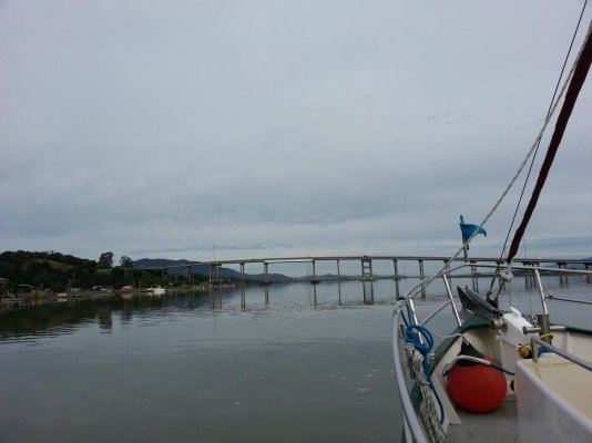
Boating in the San Francisco estuarine waters is mostly year-round.
 

Attachments

  • Petaluma entrance.jpg
    Petaluma entrance.jpg
    75.4 KB · Views: 23
Sister boat Cormorant found going north to San Francisco unpleasant, so had the boat boat-hauled to Washington State to continue to Alaskan waters. Lots of inland waters up there.
 
Some years ago we had a contract on an N55. Two brothers owned it with one preferring SoCal and one the PNW. For four years they did the yearly move South and North to accommodate each brothers desires. Finally they decided to sell the boat as the annual trek up and down the Coast was too difficult to schedule and enjoy.

Enter our plan to buy the boat but close the deal when the boat was delivered to Seattle from its soon to occur trek North planned for April. The brothers would not deliver the N55, an experienced Captain with one crew would do the same on my dime. The brothers were dreading the slog as previous trips had not gone well weather wise to fit their schedules.

They hated the annual commute primarily because they didn't have the time for weather delays and got tired of night travel and big seas. The deal fell apart for strange reasons on their part but the sale was prompted by Pacific Coast commuting. With Coastal experience under my belt I can well understand the point to point niceties of the trek. But unless willing to beat one's self up, a quick comfortable commute like the East Coast is uncommon.
 
This discussion has been hugely valuable for me. Thank you all. And I'm not even the OP. :D
 
Much to explore even before going up into the Delta. Many boaters never leave it.
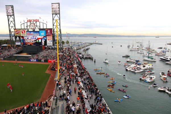
Must include at least one trip to McCovey Cove.
 

Attachments

  • cove.jpg
    cove.jpg
    158.4 KB · Views: 26
Fishermen go up and down the coast year round. 50 years ago most salmon boats were about 30' and wood. My current boat made the trip from Canada to Mexico every year with a PO.
It's a matter of weather windows and tolerating weather that isn't perfect. The PNW is probably never flat. There's always a leftover swell from the last wind.
Most people have trouble going around headlands because they're too close to shore. Swells build as they come into shallow water, getting steeper, taller, and closer together. I run about 25 miles out and try to be in 300+ fathoms. Once the water depth is over your head, it doesn't matter how deep it is.
 
When I was delivering, I loved threads like this. The apocolyptic accounts of weather off the CA/OR/WA coast was great for my business.

But the reality was I made many trips non-stop. I did a quick check and I could leave Ensenada right now and very likely get to SF in 3-1/2 days time non-stop. But there's a bit of technique to delivering a boat north along the coast: the winds are generally diurnal, meaning it's usually calm at night, some gusts around sunrise, then calm, then start building late morning and peak around 3-4 in the afternoon. So in the afternoon, it pays to tuck-in close to shore, about a 1-1/2 miles outside the surf line. Knocks-down about half the seas. At night, the seas die-down and your drift offshore 5-10 miles to avoid crab traps. You still end up sleeping in the aft-most portion of the boat, but it's definitely workable on most boats 40+ foot in length. If it weren't, there would be no fishery.

Peter


Good insight and Informative. Thanks!!
 
Wifey B: Well, if price is an object, then San Diego is not your solution. Much higher prices than the PNW, so perhaps you need to think of either staying in the PNW or going further. And, by further, I don't mean Ensenada. There you will get a glimpse of Mexico. I mean further South into Mexico and the beauty of the Sea and the towns. :)


I have spent 4 years in San Diego sailing and getting to know the area. San Diego is part of the solution and I look forward to returning for a visit. I don’t see it as “price is an object”as a deterrence. Didn’t get to where I’m at by being foolish with money either. Not much difference Ensenada to SD. Price or people. I agree with you, further south is when it gets good. Water temp, clarity and calmness. La Paz and Loreto are the south destinations I had in mind. But open to further south once I get down there.
 
.....
It's a matter of weather windows and tolerating weather that isn't perfect. The PNW is probably never flat. There's always a leftover swell from the last wind.

This pretty well sums it up. After a while you get used to the slop ---- to a point. It's generally a handful of hours in the afternoon and you can usually 'see' to the other side.

Most people have trouble going around headlands because they're too close to shore. Swells build as they come into shallow water, getting steeper, taller, and closer together. I run about 25 miles out and try to be in 300+ fathoms. Once the water depth is over your head, it doesn't matter how deep it is.

Depends on what weather you're talking about. Large swells from distant storms - definitely true. Steep chop from winds and fetch, I've found going in close knocks-down a lot of the intensity. Depends on what you're dealing with.

Peter
 
About half were on Nordhavns, mostly N47s, then N40s, and a few of the last 46s (which are not particularly good in headseas due to fuel tanks being far aft). I ran several 57s, but those were mostly south and one to Fort Lauderdale.

There is no magic to the Nordhavn except to say they are watertight and gear is well fastened so nothing hobbles loose. Those two things - especially being able to endure spray, are two of the most important but under-reported attributes to moving a boat north along the Pacific coast. A LOT of boats can be made to be like that, but boats like Nordhavn come that way. Not much owner intervention needed. Oh, and they are invariably stabilized. But again, not unique to Nordhavn, just common.

I am most knowledgeable about Pacific coast weather so I will not extrapolate, but my experience is you can almost divide the day into 6-hour blocks, at least from late April through end of September. Winds pickup late morning and did down early evening. Peak is around 25-30 kts and seas are around 6-feet at around 7-8 seconds, but only for a few hours. That's when you take the beach route.

Exceptions are the major points of which there are three - Conception, Sal/Buchon, and Mendocino. Heading north, I always timed departure to hit Conception around midnight, but if there's a strong current running, it can still be pretty bumpy for a couple hours. It doesn't always work out that way, but usually does.

I remember being somewhere north of Mendocino one night in a N46. It was pitch black but seas felt pretty big. 10-feet? More? Not sure - always feels worse at night when you can't see. Every so often it felt like we dropped 2-stories down an elevator shaft. The boat speed would stall, the whole boat would shudder, then slowly pickup momentum again. I still managed to get a little sleep. We had some leftover Stouffer's lasagna that we heated on the Lugger engine though opening the fridge was a jack-in-the-box experience. But for the most part, going north wasn't a huge deal. If you waited for a perfect ride, well, it may never come. This is where a powerboat shines vs a sailboat. They are cold, wet, and slow.

My point being is that I define a strong boat differently than most. Stuff has to be well fastened. Ports watertight. For the most part, you are enduring 2-6 hours of junk, not days of it. And there are ways to reduce the effect during those 2-6 hours.

Finally having adequate range so you don't have to waste time going in or out is a huge advantage. Yes, there are plenty of places to stop, but after a while, there isn't anything new. Besides, I just plain enjoy being on the water. The reason I did so many non-stop trips is I just liked it.

Peter

EDiT - the above said, I wouldn't do it for pleasure every year. I'd do it occasionally, but that's it. It's a really long run and a lot can go wrong. Oddly, April is the most consistently windy month on the coast so not a great time to move a boat north but scheduling nudges that direction so your in the PNW in June or so. Schedule is hugely variable. OP is in PNW. Go south to La Paz, spend a season in the Sea of Cortez, ship the boat back to Victoria or Nanaimo. Call it good.


Excellent post. Thank you.
 
We live on a 41' Mainship Expedition in San Diego - Shelter Island for about 5 months (November to April) and own a home on Whidbey Island in Washington where we live the rest of the time. We usually charter in the summer for a San Juan/Gulf Island trip and have relatives in the Seattle area with boats for cruising or crabbing. It really isn't that expensive to live aboard in SD and not all that difficult to find a slip if you don't live aboard year round. We have a reliable guy who maintains and watches over our Mainship when we aren't in SD. All in all, this has been a great solution for us
 
Last edited:
We live on a 41' Mainship Expedition in San Diego - Shelter Island for about 5 months (November to April) and own a home on Whidbey Island in Washington where we live the rest of the time. We usually charter in the summer for a San Juan/Gulf Island trip and have relatives in the Seattle area with boats for cruising or crabbing. It really isn't that expensive to live aboard in SD and not all that difficult to find a slip if you don't live aboard year round. We have a reliable guy who maintains and watches over our Mainship when we aren't in SD. All in all, this has been a great solution for us


Sounds like a great arrangement. You were able to get live aboard status sounds like. I would likely leave mine there as well. Must be great in the winter.
 
Yes we got a slip fairly easily for our size. We've been at 2 marinas and both have been great. We wanted access to a pool and workout room so we are quite happy where we are. Approximately $1200 a month plus electricity. Send us a private message if you want details.
 
Last edited:
This discussion has been hugely valuable for me. Thank you all. And I'm not even the OP. :D

I concur! Very eye opening. The experience on this forum is amazing. Very much appreciated. Thank you.
 
Yes we got a slip fairly easily for our size. We've been at 2 marinas and both have been great. We wanted access to a pool and workout room so we are quite happy where we are. Approximately $1200 a month plus electricity. Send us a private message if you want details.


I love Shelter Island. You’re right, the Marinas for the most part have pools, hot tubs and fitness centers. It’s like being at a resort for $1200 a month. Pretty hard to beat. I would do that deal in a heart beat with a live-aboard slip. Very cool pubs and restaurants all within walking distance. One night I was in the boat there and I can here the band playing a few doors down. Sounded really good. Playing a Huey Lewis and the News tune. Went for a walk and sure as it rains in the PNW, it was them live. Very good time there.
 
Forgot to mention we had our Mainship trucked down from the Seattle area. And yes, the outside concerts at Humphrey's are close by and accessible with our dinghy. Sweet life down there!
 
They hated the annual commute primarily because they didn't have the time for weather delays and got tired of night travel and big seas. The deal fell apart for strange reasons on their part but the sale was prompted by Pacific Coast commuting. With Coastal experience under my belt I can well understand the point to point niceties of the trek. But unless willing to beat one's self up, a quick comfortable commute like the East Coast is uncommon.

Which is why the east coast boats often have huge amounts of hours on them compared to ones in the PNW. The annual Maine to Florida/Bahamas trek.
 
Pete's advice is very good but the cruising conditions he describes from the PNW to San Diego or Ensenada extend all the way to Cabo, actually to the Equator and probably beyond. If you want to stay in Ensenada for the entire period fine but there are no places to do short term cruising. Ditto SD. Park the boat and have someone drive a car down to you (SD or Ensenada) to use for site seeing the area.

Or maybe you could have your boat trucked overland (and back) from Ensenada to the Sea of Cortez, then you will have great cruising and weather and sea conditions.

Just kidding, but maybe not.
 
For planning purposes, Pilot Charts of the North Pacific, are 12 large pages (1 per Mo) that show 30 yr averages of wind velocity/direction, wave height, current, temperature and more in a grid of the entire N Pacific by month.. It is facinating to look at the changes by month as you flip the chart pages.
Of course you need to have local current forcasts before casting off, but for planning purposes, it is a lot of info in just 12 charts and well worth the price.
 
Lots of good information on this thread. I can't speak to any travel north of Pt. Conception but from San Diego south I can give some perspective. We live aboard in San Diego and since 2006 we have made 8 trips from SD to either La Paz or on alternate years over to the Mexican mainland from La Cruz down to Barra de Navidad. All obviously with the return trip or as it can be called the "Baja Bash". My wife and I run our 58 ft. Pilothouse by ourselves. We are lucky to be retired which allows us to follow the cardinal rule for cruising up and down the coast of Baja and that is do not have deadlines! We wait for windows and have certain stops along the way such as Turtle Bay, Santa Maria, Mag Bay where we rest and wait. We also use Weather Routing and let them know our constraints are low. The last trip North in 2020 we waited 8 days in Santa Maria for a good window up to San Juanico. Not a problem. Great safe secure anchorage. So I guess it all comes down to your tolerance level and scheduling. (preferably lack of.) Obviously our MO is not everyone's cup of tea but it works for us. Easier on us and easier on our boat. We have always enjoyed Mexico and will be off again if everything comes together about mid November this year.
 
San Diego is the last place you want to be. Outrageous prices for marinas, long waits for live aboard slips, and everything else expensive. We’re here but only for a short time.

Ensenada is good, Cruiseport much cheaper than Marina Coral but without the amenities if you desire those.

Personally, I’d just continue on to mainland Mexico, better weather, food and people.

When I checked last year, Marina Coral was about 15%-20% more expensive than Cruiseport ($500/mo vs $425-ish for a 40-foot slip). Not a deal breaker. I definitely prefer Cruiseport to Coral not because it's cheaper, but it's closer to downtown. For my tastes, Marina Coral is a bit too gringo and curated. Sort of a walled garden. For resort-style marina with restaurants within walking distance, I think San Diego is a much better value, albeit at 2x the price. It's been many years since I was in MDR, but that place is a veritable adult Disneyland of shops and restaurants. A lot of temptation to swipe a credit card.

As others have said, with exception of PNW, San Francisco Bay & Delta, and the Sea of Cortez, the Pacific Coast is 'coastal passagemaking,' mostly transits of at least 50nm without a lot of interesting stops between. There are some interesting offshore islands such as the Channel Islands National Park off Santa Barbara, but they are pretty remote.

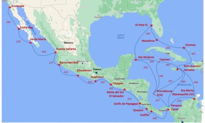
To give some idea, attached is a chartlet I assembled a while back to interest my wife in heading south. Idea was to limit overnights. Now, for you ICW folks, this may seem like really long legs but compared to 500 nm / 72-hour legs, this was palatable to my dearest. We may add a season in Sea of Cortez which can be short-hopped for as long as you desire. Pretty desolate - sort of similar in style to eastern Bahamas.

Peter
 

Attachments

  • Ensenada to Florida Chart.jpg
    Ensenada to Florida Chart.jpg
    84.8 KB · Views: 39
Last edited:
One facet of the trek along the Pacific Coast not only involves range, but that some of the harbors may be closed because of conditions at the bar. When we ran up and down, we looked at the conditions (Bar conditions, sea state, tide and currents) at our destination. Fortunately we had vessels which had the range to avoid any stops between Los Angeles and the PNW.

A second factor not mentioned, is the condition of fuel in tanks before taking the run. Many vessels making the run have not been in rough conditions for some time and sediment is sturred up from the bottom of the tank. We have seen a number vessels disabled because of plugged up fuel filters, then running out of filters or running down the batteries trying to restart. Be sure your fuel is polished, and that you have clean fuel. Take plenty of filters and monitor the status of engine starting banks.
 
This is probably an easier trip in a sail boat Than most trawlers, but I have a fantasy of doing a 2 year loop from the Pacific NW, down the coast to California, then Mexico, then across to Hawaii for the second winter, then in spring heading from Hawaii to Kodiak Island in Alaska, and working your way down Alaska for the summer, ending up back in the PNW in September. Not sure if I will ever convince my wife to do it, but I think it would be pretty great.

I have a friend that did the Hawaii-Kodiak-Seattle-Mexico part of it last year in a sail boat and had a really good time. I was very jealous. I wanted to join him as out boats were together in Hawaii, but My boat was not ready for the Alaska part of the trip at the time. I had no usable anchor, dingy, heat, generator, etc. I just came strait home to Anacortes.
 
Last edited:
This is probably an easier trip in a sail boat Than most trawlers, but I have a fantasy of doing a 2 year loop from the Pacific NW, down the coast to California, then Mexico, then across to Hawaii for the second winter, then in spring heading from Hawaii to Kodiak Island in Alaska, and working your way down Alaska for the summer, ending up back in the PNW in September. Not sure if I will ever convince my wife to do it, but I think it would be pretty great.

I have a friend that did the Hawaii-Kodiak-Seattle-Mexico part of it last year in a sail boat and had a really good time. I was very jealous. I wanted to join him as out boats were together in Hawaii, but My boat was not ready for the Alaska part of the trip at the time. I had no usable anchor, dingy, heat, generator, etc. I just came strait home to Anacortes.

If someone hasn't done so already, name it! Pacific Great Loop, Greater Loop,
The other Loop, etc.
 
When I checked last year, Marina Coral was about 15%-20% more expensive than Cruiseport ($500/mo vs $425-ish for a 40-foot slip). Not a deal breaker. I definitely prefer Cruiseport to Coral not because it's cheaper, but it's closer to downtown. For my tastes, Marina Coral is a bit too gringo and curated. Sort of a walled garden. For resort-style marina with restaurants within walking distance, I think San Diego is a much better value, albeit at 2x the price. It's been many years since I was in MDR, but that place is a veritable adult Disneyland of shops and restaurants. A lot of temptation to swipe a credit card.

As others have said, with exception of PNW, San Francisco Bay & Delta, and the Sea of Cortez, the Pacific Coast is 'coastal passagemaking,' mostly transits of at least 50nm without a lot of interesting stops between. There are some interesting offshore islands such as the Channel Islands National Park off Santa Barbara, but they are pretty remote.

To give some idea, attached is a chartlet I assembled a while back to interest my wife in heading south. Idea was to limit overnights. Now, for you ICW folks, this may seem like really long legs but compared to 500 nm / 72-hour legs, this was palatable to my dearest. We may add a season in Sea of Cortez which can be short-hopped for as long as you desire. Pretty desolate - sort of similar in style to eastern Bahamas.

Peter


Great information. Love the chart. Put things in perspective.
 
One facet of the trek along the Pacific Coast not only involves range, but that some of the harbors may be closed because of conditions at the bar. When we ran up and down, we looked at the conditions (Bar conditions, sea state, tide and currents) at our destination. Fortunately we had vessels which had the range to avoid any stops between Los Angeles and the PNW.

A second factor not mentioned, is the condition of fuel in tanks before taking the run. Many vessels making the run have not been in rough conditions for some time and sediment is sturred up from the bottom of the tank. We have seen a number vessels disabled because of plugged up fuel filters, then running out of filters or running down the batteries trying to restart. Be sure your fuel is polished, and that you have clean fuel. Take plenty of filters and monitor the status of engine starting banks.


Great suggestion on fuel polishing.
 

Latest posts

Back
Top Bottom