Problem in the Swinomish Channel

The friendliest place on the web for anyone who enjoys boating.
If you have answers, please help by responding to the unanswered posts.

av8r

Senior Member
Joined
Dec 20, 2011
Messages
316
Location
USA
Vessel Name
Selah
Vessel Make
Ocean Alexander 40
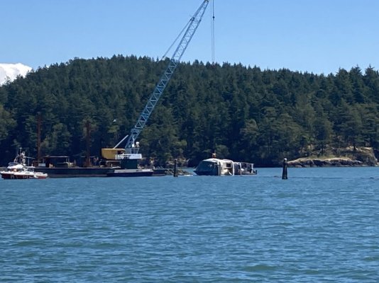
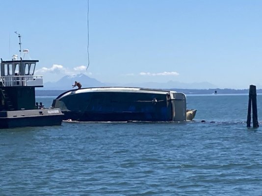
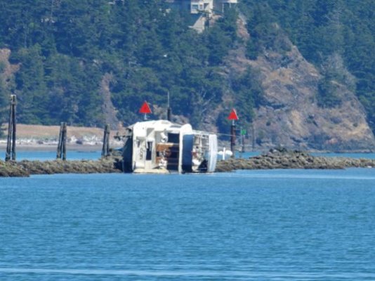
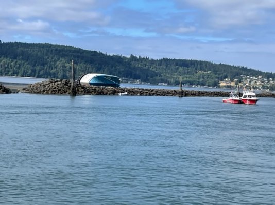
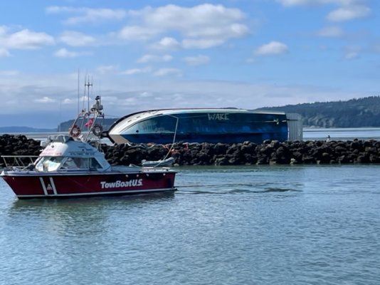
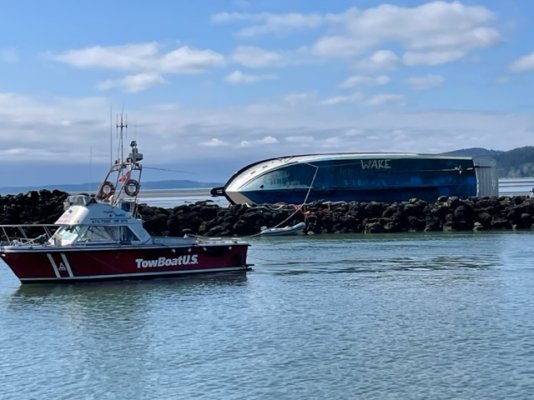
There was a thread a while back where somone dicussed the difficulties of transiting the Swinomish Channel. Having done it several times, including high tide, low tide, fog and rain, it doesn’t seem too challenging, but this captain found otherwise. These photos were taken today about 1200. I have no idea what happened and haven’t found any info but it appeared the boat was on its side on the wrong side of the tailings piles on the south side. He may have gone aground on the pile and then fallen off it sideways as the tide went out. Rule 1 for the channel, stay in the channel. A bad day.
 

Attachments

  • 963C2958-6757-4C70-A2A6-8A6DFB750A81.jpg
    963C2958-6757-4C70-A2A6-8A6DFB750A81.jpg
    131.9 KB · Views: 196
  • 720AA6B8-574F-445B-8385-48AFB79824C5.jpg
    720AA6B8-574F-445B-8385-48AFB79824C5.jpg
    95.1 KB · Views: 153
Reminds me of the folks we helped in Hawaii who were arguing as to which side of the red buoy they were supposed to be on shortly before they ran up on the reef . . . . Spoiler Alert, the wife was right, and the husband was the skipper of a nuclear ballistic missile submarine . . . .:facepalm:
 
... it doesn’t seem too challenging, but this captain found otherwise.


Is this on the straight stretch west of "Hole in the wall"? Hard to imagine.
 
Our late friend Capt. John Aydelotte who owned Vessel Assist/Tow BoatUS in Cornet Bay for many decades always referred to the south channel as "The Million Dollar Mile"...
 
Our late friend Capt. John Aydelotte who owned Vessel Assist/Tow BoatUS in Cornet Bay for many decades always referred to the south channel as "The Million Dollar Mile"...

In Silva Bay we have "shipyard rock". The mark is a standard Port hand Green, with Fl every 4 seconds.
 
Is this on the straight stretch west of "Hole in the wall"? Hard to imagine.

Yes, about halfway between the west entrance and Goat Island.
 
I keep my boat in La Conner, and am in and out of that channel all the time.

I saw a boat once, coming from the south, and turned too early into the channel. Ended up about where this one was, on the wrong side of the breakwater.

At high tide, the breakwaters are under water and the north/south current can push you over one even when you think you're pointed down the middle of the channel. Scares me to death when I'm going out in the fog and trying to keep to the side to avoid any oncoming traffic.

A couple weeks ago, in the middle of the "dredged" channel, with the tide at -2.5, my depth sounder registered less than 4 ft, with a foot left to fall.

This is not a place to let your guard down.
 
Anybody can make a mistake in this channel if your not constantly updating your position.

And on very low tides water depth is always fairly skinny at low tide at the so. entrance. I went across the so. entrance w about 6” below keel. Numerous other times w a little more water. I slow down and survey my position carefully w less than 1.5’ of water.

Boat wakes are another problem. Have a plan .. A and B. Attack at an angle (about 30 degrees) depending on relevant variables.
 
I keep my boat in La Conner, and am in and out of that channel all the time.

I saw a boat once, coming from the south, and turned too early into the channel. Ended up about where this one was, on the wrong side of the breakwater.

At high tide, the breakwaters are under water and the north/south current can push you over one even when you think you're pointed down the middle of the channel. Scares me to death when I'm going out in the fog and trying to keep to the side to avoid any oncoming traffic.

A couple weeks ago, in the middle of the "dredged" channel, with the tide at -2.5, my depth sounder registered less than 4 ft, with a foot left to fall.

This is not a place to let your guard down.
I think you've figured out the cause. Looks to me like his keel hit the rocks, rolled him on his side and pushed him over to the mud flats. If he'd come from the south across the mud flats at high tide I'd expect to see how bow burried in the rocks.
 

Attachments

  • Swin wreck.jpg
    Swin wreck.jpg
    53.2 KB · Views: 135
  • Swin wreck chart.jpg
    Swin wreck chart.jpg
    110.3 KB · Views: 84
Looking at the photo from Portage...


I see a breakwater right alongside the red channel markers, and Mr. Rhodes pointed out the breakwater is under water during high tide. Yep, that's a bad grounding waiting to happen.


My goodness, I feel sorry for the skipper. There but for the grace of God go I.


Reminds me of the time we were on the Tennessee River at dusk, tired and cold, and saw the Watts Bar marina but didn't see the entrance or any channel markers for the entrance. I jumped on the radio and requested local knowledge. Fortunately, someone was monitoring, and directed us almost a mile downriver.


Leaving the next morning, the light of day (and my polarized sunglasses) revealed all of the just barely submerged rocks surrounding the place.


Cheers,
Mrs. Trombley
And the ebb runs across the channel north to south. Easy to get set onto the rocks if not paying attention. There are range markers to assist keeping in the channel but you have to use them.

Sent from my SM-T500 using Trawler Forum mobile app
 
There but for the grace of God go I.


It's not that hard; only requires that you have basic skills and pay attention.


I've run it in boats from 22' to 43', sail and power. The only challenge I ever encountered was the azzhole coming the other way "taking his half in the middle.":lol:
 
I transit this cut on a regular basis. I don’t find it particularly challenging and yet I see boats ending up on the break water rather frequently.

On the one hand, the breakwater is below the surface during a significant portion of the tide cycle. You see nothing but miles of murky water in almost all directions and there is a red can off to south that could fool you into thinking it’s marking the entrance when it’s in fact far south of the entrance. One look at a chart would tell you how dangerously shallow the area is. However, I can certainly see how some one who is not paying attention could get confused and wander into the breakwater. I just don’t see it happening to some one who is paying attention.
With respect to the old salts and certainly not aimed at tiltrider1. Learn to use ranges. The easiest thing there is for accurate positioning in a place like this as long as you can see them. There is a range for that portion of the channel. More accurate that GPS + plotter.


1658500063170.jpg1658500140746.jpgScreenshot_20220722-073802_OpenCPN.jpgScreenshot_20220722-073537_OpenCPN.jpg

Sent from my SM-T500 using Trawler Forum mobile app
 
A bit more info. This happened around 2100 on Saturday night. We came through on Sunday morning. The vessel was approaching from the south and was unfamiliar with the area. They were no where near the channel but were trying to cut the corner and get into it. As has been previously noted the channel is clearly marked on the charts but from the helm at high tide it looks deceptively wide open especially at dusk on a very high tide. Fortunately no one was injured. Boat is a total loss.

Portage_Bay,
There is no range going Northbound, only south.

One lesson I learned, and fortunately I was paying attention, is to be careful with the autopilot.

I carefully entered a course on my newly installed Furuno, and set the way points to go well clear of rocks guarding a reasonably narrow channel I was going to go through. (And I know this channel reasonable well).

The autopilot initiated the turn well before - unreasonably early but any standard except more open water - the way point and wanted to cut the corner taking me over the rocks so I took manual control over.

I went onto the menu settings and changed the setting to make sure the turn initiation occurs much closer to my way point. I recommend others review their settings just in case.

I wonder if that is what happened to them ?
 
Last edited:
A bit more info. This happened around 2100 on Saturday night. We came through on Sunday morning. The vessel was approaching from the south and was unfamiliar with the area. They were no where near the channel but were trying to cut the corner and get into it. As has been previously noted the channel is clearly marked on the charts but from the helm at high tide it looks deceptively wide open especially at dusk on a very high tide. Fortunately no one was injured. Boat is a total loss.

Portage_Bay,
There is no range going Northbound, only south.
That was a high tide at that time. Unfortunate for him. On a lower tide he'd have probably just gotten stuck on the mud flats and freed himself on the next tide.

Yes the range markers are across from the Swinomish Channel entrance on Dugualla Bay and easier to use when transiting westerly towards the markers. However thay are very usable when transiting away from the markers in an easterly direction by looking over your stern. I've been running that channel long before I had GPS when using the range was the only way to be sure I was in the channel at high tide. Often on a boat without a fly bridge so I ran with the wheel house door open to check my position frequently.

Sent from my SM-T500 using Trawler Forum mobile app


Bit tougher to do on our new boat so I have a set of landmarks that I use when heading northbound. We are moored in LaConner so this is an every time thing for us.

As for relying on the chart plotter, I don’t trust it in the channel and rely on the depth sounder and range markers.

Also be careful as the latest LNM notes the the Green 13 marker has been relocate farther North. Doesn’t seem like a very good idea to me.
Agree, the only safe way to transit that channel. Came through yesterday evening crabbing down the channel to stay on the range. The wreck is still there. Pic taken at 17:10. The tide height was about 7.5 ft, easy to see how the rocks would be underwater at a 10 ft + tide which is about what it was when the wreck happened.

Two assistance tow boats anchored in the channel near the wreck. Apparently doing nothing.
 

Attachments

  • Swin wreck 0722.jpg
    Swin wreck 0722.jpg
    111.1 KB · Views: 66
Seems likely he was running on the east side of the red bouys across the flats of Skagit Bay.
 
Last edited:
It looks like they are waiting for high tide.
 

Attachments

  • IMG_9323.jpg
    IMG_9323.jpg
    105.4 KB · Views: 67
  • IMG_9324.jpg
    IMG_9324.jpg
    119.7 KB · Views: 66
  • IMG_9325.jpg
    IMG_9325.jpg
    116.6 KB · Views: 69
  • IMG_9326.jpg
    IMG_9326.jpg
    115.1 KB · Views: 58
Reminds me of the folks we helped in Hawaii who were arguing as to which side of the red buoy they were supposed to be on shortly before they ran up on the reef . . . . Spoiler Alert, the wife was right, and the husband was the skipper of a nuclear ballistic missile submarine . . . .:facepalm:

The skipper will have been operating under the international IALA A standard which every country in the world (that isn't under direct USA influence such as Korea, Japan and Canada) uses. For some crazy reason the USA (and it's subjects) uses the direct reverse of of the international standard that was agreed in 1976. It drives me crazy in the British and American Virgin Islands!
 
Yeah, we went by there last Thursday on the way to the San Juans and it was quite the site!! Would love to hear what happened on this run aground.
 
I spent a couple of seasons going in and out of La Conner. I'd suggest it requires a fair level of respect regardless of your experience level. We never had a problem thankfully but I agree the south entrance is extremely skinny and requires diligence.
The other place we saw problems is in downtown La Conner, it is fairly unique in the speed of the peak current running through there. We saw more than a couple instances of people approaching a dock (either in town or at the marina) and not understanding the magnitude of the current. Sometimes it would take them a half dozen approaches to figure what direction and angle. One time they got one end tied but the current got the other end and pushed it out before the other line was set... not pretty but they finally recovered.
Charts have tidal current indicators out in Skagit bay, but non inside the Swinomish channel so it helps to have a little local knowledge. Of course if you're going to dock in town, try to catch it at or near slack.
 
Anyone every figure what boat this is?
 
In fairness to the skipper, there are a couple of things that could have contributed to his coming to grief.
My understanding is that it was nighttime when it occurred, and let’s assume there was he was not impaired. If he wasn’t paying absolute attention the lighted markers could have been lost due to the background lights. If a skipper isn’t familiar with the south entrance, identifying the markers can be a challenge even in the daylight. The gps signal could have been degraded causing him to be out of position. I’ve had some goofy readings in that area that I attribute to NAS Whidbey. They fly squadrons of jamming aircraft there and I don’t know anything more than they jam signals, I gotta believe that gps is one of them. If he was on Autopilot and not paying very close attention to his position, as happens all too much, and even if the gps is fine, a mistake in routing and the results can mean a collision with something.
Whatever the circumstances they are lucky to have survived without major injuries.
Re the Towboats appearing not to be doing anything, I’m guessing they are guarding the wreck both from less than honest people and the salvage claim.
 
Does anyone know if they got the boat out?
 
Reminds me of the folks we helped in Hawaii who were arguing as to which side of the red buoy they were supposed to be on shortly before they ran up on the reef . . . . Spoiler Alert, the wife was right, and the husband was the skipper of a nuclear ballistic missile submarine . . . .:facepalm:
The skippers give orders, it doesn't mean they know how things work.
 
Back
Top Bottom