IPAD & Navionics?

The friendliest place on the web for anyone who enjoys boating.
If you have answers, please help by responding to the unanswered posts.

Capt. Rodbone

Senior Member
Joined
Sep 6, 2020
Messages
172
Location
U.S.
Vessel Name
SV Stella Polaris MV Sea Turtle
Vessel Make
1978 VanDine Gaff rigged schooner, 1978 Grand Banks Classic Trawler
Next week we will begin bringing our new to us Grand Banks 42 Classic down from Nashville TN to Guntersville AL, where will will likely keep it for the winter. Though suggestions at this great site I located online and ordered some chart books that should be here by weeks end.
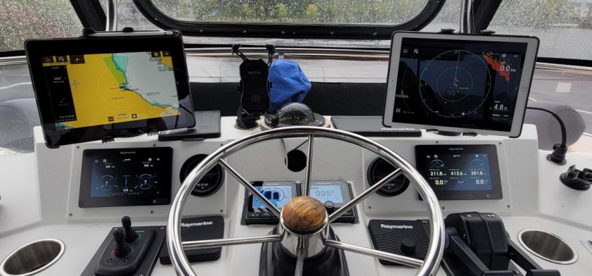
I’ve been watching on YouTube the postings of a person who is doing the Loop and recently came down the TN River to the Tenn Tom. His channel today discussed what he has used for navigation, which has been Navionics on a Samsung tablet. He says he purchased an IPAD not knowing it doesn’t have “auto navigate” and it just didn’t work well. Do any of you know if he’s correct about this and have you experienced the same problems with an IPAD? Sine I have one already I would certainly prefer to use what I have, but I don’t suppose $220 is the end of the world if a Samsung will serve me better.

Thanks in advance for your thoughts.
 
You need to make sure the tablet has a gps chip. The ipads with cellular capability also include the chips, the wifi only ones don't (at least on the older ones). You can get an external gps device to connect via bluetooth if it doesn't have the gps chip but it is a bit of a hassle and best to avoid when you are buying an ipad for this purpose.
 
I went a similar route for my summer cruise. Bought a Samsung Galaxy Tab S7+. My choice for software to supplement my Garmin and NOAA software, was Aquamaps. I find the crowd source information from Active Captain and Waterway Guide very useful. The map updates are very quick.

16334713052275702799372307845635.jpg

Ted
 
I don't have a mouse for my ipad so I found using my pc to add routes to Navionics was much easier. You can then access them on your ipad if you choose.
 
You need to make sure the tablet has a gps chip. The ipads with cellular capability also include the chips, the wifi only ones don't (at least on the older ones). You can get an external gps device to connect via bluetooth if it doesn't have the gps chip but it is a bit of a hassle and best to avoid when you are buying an ipad for this purpose.

We have WiFi iPads. Don’t want to pay for the cellular subscription. We have used a Dual xgps150 Bluetooth external gps (about $109) for a number of years. Has been compatible with a number of navigation apps including iNavX, Garmin Bluecharts, Aquamaps, etc BUT do not know if it is compatible with the Navionics mobile app. I’m on the TN River as well and have been lazy about downloading the Navionics app but want to because the Navionics TN River charts are very good. Guess I’ll download and let you know.
 
You don't have to have a cell data plan for the iPad. You have to have a cellular capable iPad to get the gps chip. The wifi only iPads lack the gps.
 
The Samsung wifi tablets have a built in GPS. I tether it to my phone for map updates.

Ted
 
We have WiFi iPads. Don’t want to pay for the cellular subscription. We have used a Dual xgps150 Bluetooth external gps (about $109) for a number of years. Has been compatible with a number of navigation apps including iNavX, Garmin Bluecharts, Aquamaps, etc BUT do not know if it is compatible with the Navionics mobile app. I’m on the TN River as well and have been lazy about downloading the Navionics app but want to because the Navionics TN River charts are very good. Guess I’ll download and let you know.

OK downloaded app. Works while I’m on WiFi. By the way, if you have an iPhone, can use hot spot feature to provide WiFi to iPad which will work. BUT left Dual gps on boat. I’m at home. Let you know over weekend how Dual gps works.
 
Last edited:
I went a similar route for my summer cruise. Bought a Samsung Galaxy Tab S7+. My choice for software to supplement my Garmin and NOAA software, was Aquamaps. I find the crowd source information from Active Captain and Waterway Guide very useful. The map updates are very quick.

View attachment 121808

Ted

Have two boats. One on the East coast of Florida and do the Bahamas. Absolutely love Aquamaps in that location. Second boat on the TN River. Aquamaps unfortunately are not detailed enough for the River.
 
I have been using a cellular capable iPad with Navionics for years, and it works well. One reason to add a cellular plan for marine use is that, when out of wireless range, I find that personal hotspot works MUCH better from my iPad than from my phone. (This has been invaluable in allowing me to work from my boat when at anchor.) I assume this is because of a larger internal antenna in the iPad compared to my iPhone. If you already have a Verizon plan, adding a line for an iPad is not too expensive.
 
Another fan of Ipads. I started with one, now use 2 - 12.9" Pro (cellular version for GPS chip). I can sync them to my Raymarine Axiom's I have down below and also use them as stand-alone for Navionics as well as some other marine apps.
LOVE having the large screens and not having to pay $3,000-$5,000 more because my screen is larger!!!

The other pic is something else I am working on for the lower helm gauge panel. Replaced my analog gauges w/ a SeaGauge (analog-2-N2K converter). Up top I get the gauge info on the Axiom 7" screens. Down below, I have 9" screens and will be doing a dash face-lift to incorporate a 15" touchscreen attached to a Chromebook... :)
 

Attachments

  • 20211005_153520.jpg
    20211005_153520.jpg
    118.3 KB · Views: 71
  • 20211005_094010.jpg
    20211005_094010.jpg
    96.2 KB · Views: 57
You don't have to have a cell data plan for the iPad. You have to have a cellular capable iPad to get the gps chip. The wifi only iPads lack the gps.

Correct, but if you only have wifi a BadElf external gps receiver will solve that problem. ~$150. I find Navionics very easy to use, $29/yr on ipad mini. If I did the ICW I would add Aquamaps.

I also store all manuals on the ipad, along with numerous weather and tide apps although looking out the window has beat most of the apps to date.
 
Have navionics on my IPad. Love it. Usually use a different cartography on the boats screens. And when particularly nervous Open on the laptop. The iPad also would mirror the MFD when you wanted. You just have the wrong iPad as others have said. Both our IPads live inside life proof cases so no problem taking them outside.
 
IPAD & Navionics?

MV CLASSEA uses iPads (3, 2 with GPS built-in, 1 without) exclusively today for all App’s (weather, Navionics, AquaMaps, manuals, AIS, Nebo, etc.) . . . As you have determined from this forum it is loaded with great feedback and preferences, these work for me, using the 2 with GPS for Navigation, the remaining one with more storage for backup and data storage. Each helm station, flybridge and salon have Garmin Chart Plotters (12” on the FB and 9” in the Salon) all tied into NEMA 2000.

I think a primary preference of the Samsung tablet is it’s ability to store (supposedly) more than 100 waypoints, not having one of those I can’t vouch for that feature, I can’t keep up with the day of the week, so the capacity of waypoints that the iPad’s store (what ever it is) is fine with me!IMG_7523.jpg
 

Attachments

  • IMG_7523.jpg
    IMG_7523.jpg
    103.4 KB · Views: 36
Last edited:
I also use an iPad. Another option is to hook up a YachtDevices WiFi broadcaster if you have another chartplotter. I have (2) Garmin 541s that came with the boat, which are dated, but are a good backup inside and on fly bridge. The GPS from those units, as well as other N2K data are broadcast on the WiFi, so the ipad can pick it up.
 
I have used IPads with Navionics on board for years (probably over 10?), and am very happy with their performance. As stated, the only ones with built in GPS are the ones that are "Cellular" capable, but you DO NOT NEED to have a cellular plan (I never did). We found them to be very accurate (the odd, occasional error however). I never used the "Auto Route" function, but a person could as long as they carefully checked the route for potential "problems" before use or at minimum checked carefully "as you go". We always paid attention "as we went" even in often travelled waters.

We also had a Vesper 8000 AIS on board that created it's own Wifi network that the IPads could access. The Vesper had it's own GPS antenna, and this allowed a "non-Cellular" capable IPad to be used for navigation (if desired - I had an IPad mini (3rd IPad) like that and it worked with the Vesper). This setup also displayed the AIS targets on the IPads, and any other data from other network connected devices.
Our 2002 Tug had original Raymarine electronics that still functioned well. However, I used the Plotter as basically a backup (due mainly to screen size and dated charts), and used a laptop running Rosepoint Coastal Explorer and 2 "Cellular" IPads for everyday navigation. Counting the individual GPS receivers in the IPads, I had a total of 5 GPS antennas and devices, so lots of redundancy (barring a total failure of the GPS system). (GPS receivers/antennas: Raymarine, Vesper, GPS puck for laptop - but it could easily connect to Vesper or the Puck, and the IPads (2))

We found that Navionics on these IPads was very reliable and easy to use. If memory serves, you can now access Active Captain info on Navionics as well. If not, there is an App for that if desired.
 
You need to make sure the tablet has a gps chip. The ipads with cellular capability also include the chips, the wifi only ones don't (at least on the older ones). You can get an external gps device to connect via bluetooth if it doesn't have the gps chip but it is a bit of a hassle and best to avoid when you are buying an ipad for this purpose.
All Samsungs have GPS as, I think, all androids do. It's only the Apple products that cheap out on including a GPS receiver.
 
We have used a Bad Elf gps puck for a few years with Aquamap software on a 10.5” iPad. Works fine. Never had an issue with losing satellites etc.
 
I went a similar route for my summer cruise. Bought a Samsung Galaxy Tab S7+. My choice for software to supplement my Garmin and NOAA software, was Aquamaps. I find the crowd source information from Active Captain and Waterway Guide very useful. The map updates are very quick.


View attachment 121808


Ted
Did the same, a terrific choice. We have two and run Aquamaps on one, Navionics on the other plus the MFD.
 
Been using iPads w/GPS for 7 years. Previously used Navionics, but switched to TZ iBoat a few years ago which the wireless Furuno DRS4W overlays.
 
I second the bad elf gps, works in the car too… had one for years.
 
Been using iPads w/GPS for 7 years. Previously used Navionics, but switched to TZ iBoat a few years ago which the wireless Furuno DRS4W overlays.

Plus 1 on the iPad with Time Zero. Love the "Old Fashioned" Raster charts. It is worth getting the iPad with the built in GPS (Cellular Model) as it is self contained and can be used anywhere. No Cellular or Wi-Fi service needed to navigate anywhere in the world. You are just looking for the cellular model iPad as that is the model with the built in GPS. You DO NOT have to turn on the cellular services.
 
Hey all

One other option I’ll throw out for the external gps is this:

Wireless AIS Receiver with GPS and NMEA. (QK-A026) https://www.amazon.com/dp/B07DNYHR3...abc_BTMFT2XFTVDBFC4057Z9?_encoding=UTF8&psc=1

This is an AIS receiver and gps that will broadcast over WiFi that most Nav programs will connect to and use. Not only do you get the gps, but also AIS.

While my vessels have dedicated ais solutions, I like having this as a redundant system that I frequently use to cross check and validate what I am seeing. For $150 it’s been very solid for me now for 3+ years
 
All Samsungs have GPS as, I think, all androids do. It's only the Apple products that cheap out on including a GPS receiver.

I should have said ipad rather than tablet. Some of the cheapest android unit's do not have a gps chip but I think you are right about all Samsung units having them.
 
Just don't be one of those increasing number of idiots who think they have to follow the Navionics auto routes. They are often drawn around the inside of bends which puts the boat on the wrong side of the channel when it bends left. I've encountered a number of them coming around blind curves without enough water to starboard for me to make a proper port to port meeting or time to contact them on the radio.
 
Just don't be one of those increasing number of idiots who think they have to follow the Navionics auto routes. They are often drawn around the inside of bends which puts the boat on the wrong side of the channel when it bends left. I've encountered a number of them coming around blind curves without enough water to starboard for me to make a proper port to port meeting or time to contact them on the radio.

Totally agree. For the Tennessee River, the attraction of the Navionics charts is that they provide depth contours and even show roads and bridges that were inundated when the TVA dams were installed.
 
I will reinforce that tablets work and work well for us. Between my wife and I we use three. Two for me , one at a long range for the overview, the other on a much shorter range for detail. This one is closest to me. We have 2 Samsungs and one now older Nexus.

We use Navionics on all three. I have no idea how good/bad this is for your intended river travel so no comment about that.

You MUST ensure that whatever you buy has a GPS in it. This , for us, is important. If all the unit has is cell reception for position it WILL NOT WORK as soon as you are out of cell phone range. The cell positioning does help with quicker initial location detection but by themselves are totally useless for boats unless you are NEVER out of cell range.

My older Nexus can only use GPS signals, the Samsungs use both GPS AND GLonass. SOme more expensive Samsungs can also use the Chinese system whose name I don't remember.

What ever you purchase make sure the unit can work directly with at least the GPS system.
 
OK downloaded app. Works while I’m on WiFi. By the way, if you have an iPhone, can use hot spot feature to provide WiFi to iPad which will work. BUT left Dual gps on boat. I’m at home. Let you know over weekend how Dual gps works.

WiFi ONLY iPad: Navionics app accepts gps input from both iphone hot spot and Dual XGPS150A, said another way, the boat icon moves on the maps as it should.
 
I’ve got a Garmin chart plotter and use an iPad for backup and planning. I find the iPad much easier to use and autorouting works great.

The iPad has to be a cellular version to come with built-in GPS, but you don’t need to activate or pay for the service.

The only problem I’ve had with using the iPad is that it’ll shut down for over-temp if it spends too much time directly in the hot sun.
 
Back
Top Bottom