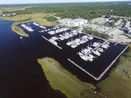
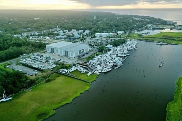
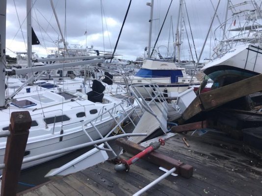
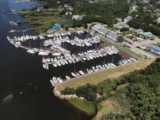
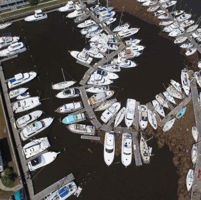
Pictures of the Southport Marina, NC that were forwarded from Hurricane Isaias. No reported injuries but a lot of damage. The before and after.
You are using an out of date browser. It may not display this or other websites correctly.
You should upgrade or use an alternative browser.
You should upgrade or use an alternative browser.
Hurricane Isaias, Southport marina damage
- Thread starter Larry M
- Start date
The friendliest place on the web for anyone who enjoys boating.
If you have answers, please help by responding to the unanswered posts.
If you have answers, please help by responding to the unanswered posts.
rslifkin
Guru
- Joined
- Aug 20, 2019
- Messages
- 7,584
- Location
- USA
- Vessel Name
- Hour Glass
- Vessel Make
- Chris Craft 381 Catalina
What a shame.... sure looks like the docks and pilings didn't hold well.
That's my thought as well. I'd expect the docks and pilings to be a lot more sturdy in an area that gets hurricanes. From what I can see in the pictures, it looks like a lot of pilings were bent over or broke, allowing the docks to move around until they broke free from the rest and/or broke apart. There are some sections of still intact dock in that pile of boats that just didn't stay where they were supposed to.
boathealer
Guru
High tide, full moon, NE quadrant of storm - recipe for a surge disaster. Doesn't look all wind-swept and bashed up. Surge may have just lifted everything up together over the top of the pilings.
rslifkin
Guru
- Joined
- Aug 20, 2019
- Messages
- 7,584
- Location
- USA
- Vessel Name
- Hour Glass
- Vessel Make
- Chris Craft 381 Catalina
High tide, full moon, NE quadrant of storm - recipe for a surge disaster. Doesn't look all wind-swept and bashed up. Surge may have just lifted everything up together over the top of the pilings.
Could be. That also speaks to a design flaw. In my mind, anywhere with floating docks in a potential hurricane area should have tall enough pilings to survive something like a 15 foot surge on top of high tide.
boathealer
Guru
I heard South Harbor Village was a similar result.
EDIT: https://www.google.com/amp/s/www.wr...ats-at-southport-marina/19218531/?version=amp
EDIT: https://www.google.com/amp/s/www.wr...ats-at-southport-marina/19218531/?version=amp
Last edited:
Surge may have just lifted everything up together over the top of the pilings.
If you look at the boats on the hard in the paved (or maybe it's gravelled) area, most seem not to have budged. That aligns with the "surge over the top" concept.
Last edited:
rgano
Guru
- Joined
- Oct 8, 2007
- Messages
- 4,995
- Location
- USA
- Vessel Name
- FROLIC
- Vessel Make
- Mainship 30 Pilot II since 2015. GB-42 1986-2015. Former Unlimited Tonnage Master
Looking at the charts around the Cape Fear area in regard to hurricane holes, there are few reasonable options close to the marinas there. Maybe a few boats could hide in the smallish area of Dutchman Creek, but even that looks iffy. If I was there, I'd have been traveling up the Cape Fear River about 25 or 30 miles.
RT Firefly
Enigma
Greetings,
I've read on another site it may have been a tornado spawned by the 'caine. Rumor???
I've read on another site it may have been a tornado spawned by the 'caine. Rumor???
psneeld
Guru
Greetings,
I've read on another site it may have been a tornado spawned by the 'caine. Rumor???
Possible...last year when Dorien went by North myrtle Beach, the marina was hardly noticing the winds but 3 tornados touched down within a mile or so...one just hundreds of yards away.
My bet is on the surge theory. Many marinas up north have pilings that are too short and docks float over/ not strong or long enough and break or pull out. Myrtle Beach Yach Club where I was lengthened some of their pilings 2 years ago...but not all. Same happened to marinas in Jersey when Sandy hit years ago, rebuilt, but same old pilings.
Last edited:
ranger58sb
Guru
We stayed a few nights at Southport Marina in Nov 2017, and I didn't think the docks were in wonderful shape, then. The end of our finger pier was all wobbly, so much so that we turned around from bow-in to stern-in... 'cause it didn't feel comfortable getting off our boat onto that unstable finger pier...
I don't remember height of the piles....
-Chris
I don't remember height of the piles....
-Chris
OP
OP

RT Firefly
Enigma
Greetings,
Mr. LM. I think "What a pile DOWN" would be more descriptive...

Mr. LM. I think "What a pile DOWN" would be more descriptive...
caltexflanc
Guru
Illustrates why we always had our put on the hill when a named storm was on the way.
Southport is right where this one made landfall and has little protection from all directions except north.
Reminds me of what happened in Ft. Pierce a few years ago.
Southport is right where this one made landfall and has little protection from all directions except north.
Reminds me of what happened in Ft. Pierce a few years ago.
O C Diver
Guru
- Joined
- Dec 16, 2010
- Messages
- 12,867
- Location
- USA
- Vessel Name
- Slow Hand
- Vessel Make
- Cherubini Independence 45
Looking at the charts around the Cape Fear area in regard to hurricane holes, there are few reasonable options close to the marinas there. Maybe a few boats could hide in the smallish area of Dutchman Creek, but even that looks iffy. If I was there, I'd have been traveling up the Cape Fear River about 25 or 30 miles.
I anchor in Dutchman creek when not staying at South Harbor Village marina. The basin in the park has shoaled in. Need less than a 3' draft to anchor in most of it. If you follow the creek up around the corner, it's wooded and peaceful with very little tidal flow, but plenty of depth. Best is to anchor with a bow and stern anchor along the shore. Bottom drops away quickly from the bank. Think the creek sees significant flow draining storm water.
As an interesting side note the canal to the East that appears to dead end just before the AICW, is the cooling water for the Brunswick nuclear power plant. The canal goes under the AICW in a pipeline and continues on the otherside to the ocean.
Ted
Woodstock
Senior Member
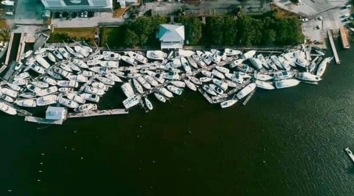
The third picture posted by the OP is actually from South Harbor Village marina about a mile west of Southport Marina. South Harbor is my home marina and our boat is part of this mess. Transient dock pilings snapped off at the height of the surge & winds.Then that dock took out part of C dock and destroyed B dock (ours). I suspect the same happened at Southport Marina but don't know for sure. There were tornados that evening but that was several hours before the surge and high winds. Here is a couple more from South Harbor and one more "after" picture from Southport Marina.
Attachments
ScottC
Guru
- Joined
- Nov 2, 2019
- Messages
- 1,516
- Location
- SWEDEN
- Vessel Name
- ABsolutely FABulous
- Vessel Make
- Greenline 33 Hybrid (2010)
The third picture posted by the OP is actually from South Harbor Village marina about a mile west of Southport Marina. South Harbor is my home marina and our boat is part of this mess. Transient dock pilings snapped off at the height of the surge & winds.Then that dock took out part of C dock and destroyed B dock (ours). I suspect the same happened at Southport Marina but don't know for sure. There were tornados that evening but that was several hours before the surge and high winds. Here is a couple more from South Harbor and one more "after" picture from Southport Marina.
WOW! Hope you managed to avoid any serious damage!
Woodstock: I'm hoping for the best for your and your marina mates. I also hope you are able to get there soon to at least see what's up.
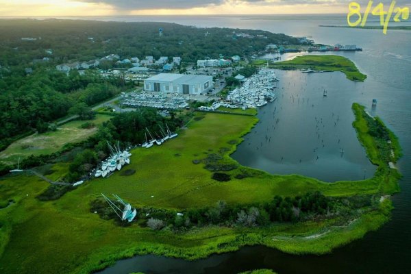
I have a question: Your second photo looks like a "before" in that it seems to match the first photo. But how do people get in and out of those slips on the "curve" even in normal times?
I have a question: Your second photo looks like a "before" in that it seems to match the first photo. But how do people get in and out of those slips on the "curve" even in normal times?
Woodstock
Senior Member
Woodstock: I'm hoping for the best for your and your marina mates. I also hope you are able to get there soon to at least see what's up.
I have a question: Your second photo looks like a "before" in that it seems to match the first photo. But how do people get in and out of those slips on the "curve" even in normal times?
I was on it yesterday for a while. Damage does not look to be real serious but will need to repair some gelcoat.
All of those pictures are "after". The first two were South Harbor Village marina. The third was Southport marina. The docks at South Harbor are not supposed to be curved. Look close and you can see all the broken dock sections that are making them curved. It's supposed to look like this.
Attachments


Ski in NC
Technical Guru
I rode the thing out at my place about 20nm N of Southport. The wind was way worse than expected. Way worse than any of the other storms that I have ridden out in the 27yrs I have owned the place. I think part of it was that the wind direction was unusual. The eye being just slightly west of us put the max wind out of the south, which for me has the most fetch. Usually the eyes go right over us (!!) and we get max wind out of the E then W. But not much out of S. I can handle E and W wind. S gave me trouble with the boat and docks, but all came out OK.
ranger58sb
Guru
Sorry to hear about South Harbor Village, too. Looks like a lot of mud shoaling, too? We stayed there on our last southbound trip and on our northbound return... nice place, the dockmaster folks treated us very well...
Best wishes...
-Chris
Best wishes...
-Chris
O C Diver
Guru
- Joined
- Dec 16, 2010
- Messages
- 12,867
- Location
- USA
- Vessel Name
- Slow Hand
- Vessel Make
- Cherubini Independence 45
We had similar wind effects on the Chesapeake. As a result of the unusual wind direction, the surrounding area lost a lot more trees than expected. Trees grow in part to protect themselves from predominant winds.I rode the thing out at my place about 20nm N of Southport. The wind was way worse than expected. Way worse than any of the other storms that I have ridden out in the 27yrs I have owned the place. I think part of it was that the wind direction was unusual. The eye being just slightly west of us put the max wind out of the south, which for me has the most fetch. Usually the eyes go right over us (!!) and we get max wind out of the E then W. But not much out of S. I can handle E and W wind. S gave me trouble with the boat and docks, but all came out OK.
Ted
Woodstock
Senior Member
Sorry to hear about South Harbor Village, too. Looks like a lot of mud shoaling, too? We stayed there on our last southbound trip and on our northbound return... nice place, the dockmaster folks treated us very well...
Best wishes...
-Chris
That's not mud. It's thick mats of marsh grass that came from the marsh on the other side of the ICW during the storm.
OP
OP

old-School
Member
Sadly, most times, we get what we pay for.That's my thought as well. I'd expect the docks and pilings to be a lot more sturdy in an area that gets hurricanes. From what I can see in the pictures, it looks like a lot of pilings were bent over or broke, allowing the docks to move around until they broke free from the rest and/or broke apart. There are some sections of still intact dock in that pile of boats that just didn't stay where they were supposed to.
FoxtrotCharlie
Guru
Sad, but from what I've read it wasn't just high water and straight winds, ie hurricane. Tornados hit that area and from personal experience not many such structures, no matter how well constructed, will stand up to those forces.
psneeld
Guru
Tornadic winds will show different damage than water casused.
From a few pics I wouldn't guess...but tornados in my opinion will cause a lot of topside damage too....
Maybe someone there can comment.
From a few pics I wouldn't guess...but tornados in my opinion will cause a lot of topside damage too....
Maybe someone there can comment.
Similar threads
Latest posts
-
 Very cool youtube series-Onne van der Wal Cruising their 32 Grand Banks
- Latest: Mainship Pilot
-

-

-

-

-
-

-
-
-