Help me understand tides

The friendliest place on the web for anyone who enjoys boating.
If you have answers, please help by responding to the unanswered posts.

Seevee

Guru
Joined
Sep 1, 2016
Messages
3,501
Location
usa
Vessel Make
430 Mainship
All,

I need to get to the next level in understanding tides, predictions and forecasts.

I use the following two sites for info:

Tide/Current Predictor

and

https://tidesandcurrents.noaa.gov/map/

They both give very similar info, and they are both predictions. As I understand it, predictions are made a year in advance and updated every six months.

While the predictions are fairly close, they don't take local conditions into consideration. Like weather fronts, highs and lows, winds, etc. Occasionally the predictions are way off with extreme highs and lows and predictions off a foot or two.

How can one adjust for the differences for more accurate forecasts?
 
Not sure you can accurately predict the variations.

For storm surges and coastal flooding, NOAA will predict as well as anyone I know.

Normal higher or lower tides from a steady wind is just a wag, better to just count on it.....winds 15 knots or greater for more than 12 hours seem to start to create hogher than normal or blowout tides.

In areas that have little or no tide such as the sounds behind the outer banks or the Indian River in Florida, they do have "wind tides". Where again stronger winds over a period of time can raise the water a foot or two. There, best to ask a local old timer if you can find an honest one.

Not the ones who tell you " man, gonna be 3 feet higher today", or the one that says, "yep, current runs through this marina at 12 knots". Those guys....abound, and should be avoided like the plague.

Current predictions I find the least accurate, but will follow the tidal prediction variances to a degree. A higher than or lower than tide may have a stronger or lesser current but really not an exact science for us amatuers.

I just take the predictions, assume a 20 percent error that would be worse for me or my boat and plan around it. You still try and take advantage of tide and current, you just cant bet on them being exactly what you want.
 
Last edited:
Hi. I think you'll be lucky to find A quick answer to this. I'm on the East Coast of UK and every now and then we get predictions of storm surges with very high tides but they're never spot on even with all the technology available to them. The best you'll get is a guess.
Estuaries will have a higher effect than open water. Wind direction and force can have as much effect as air pressure. Local knowledge and experience is the best guide. If you're at all worried err on the safe side and don't go too near the bottom. The expensive bits always touch first.
 
Like psneed said, unless there is a significant weather event, I'm not sure that you will get good wind or storm surge predictions.

Current patterns should be well established and there should be decent public or private resources for those. I use published tide and current books for my area. I also I use a couple of apps for my Android phone. One I like a lot is called Tide Times Pro which I liked so well I purchased. Another that is very handy is called Tide Chart Free, and finally Tides Near Me. Tide Chart Free has a nice graphic display but lists fewer tide stations.

There may be fewer resources for your waters. However, I notice that today the large tide range at St Petersburg is 1.5 feet. Today the large tide change in Gig Harbor is 9.5 feet. I understand that you have much skinnier water than we do, but in my mind it indicates that you may not need to worry about it too much?
 
A picture is worth a thousand words. Pick a station that has a high water condition.
https://tidesonline.nos.noaa.gov/advisory.html
It shows PREDICTED, RESIDUAL, and OBSERVED.
Predicted is based on tables and calculation. Observed is the actual level measured real-time with instruments. Residual is the difference between the 2 usually caused by local weather effects. By looking at the Predicted and applying your best guess at the Residual, you can be pretty close at guessing what the Observed will be in the near future.
 
Last edited:
A picture is worth a thousand words. Pick a station that has a high water condition.
https://tidesonline.nos.noaa.gov/advisory.html
It shows PREDICTED, RESIDUAL, and OBSERVED.
Predicted is based on tables and calculation. Observed is the actual level measured real-time with instruments. Residual is the difference between the 2 usually caused by local weather effects. By looking at the Predicted and applying your best guess at the Residual, you can be pretty close at guessing what the Observed will be in the near future.
absolutely...great info....

I just find when cruising, searching for actual numbers versus what I really have to woory about...just not worth the effort.

When planning million dollar operations to load or push barges into shallows...yep..plan, plan, plan...and pray your numbers work.
 
As discussed above, tidal variations are caused by two fundamental sources: astronomical or the effect of the moon and wind driven tides. Astronomical tides can be predicted years or centuries in advance and are reasonably accurate. Wind driven tides are not routinely predicted, as far as I know.

I used to live in an area (Oriental, NC on the Nuese River and Pamlico Sound that had absolutely no astronomical tide (the tide produced by the moon) because it was in an inland sound and the connections to the sea were few and narrow. So all tides were wind driven.

A few years ago NOAA installed tidal gauges in several locations on Pamlico Sound including one in Oriental. It gives very accurate, real time data on the state of the tide driven by the wind. It will vary in a normal year by a couple of feet high and a couple of feet low and will go as high as 8-9 feet high in nor'easters and hurricanes.

But I know of no easy source for wind tide predictions. Yes NOAA will issue predictions for storms, but not routinely otherwise. If anyone knows of a source for these type of tides, please post it.

David
 
A faulty assumption/observation is often made: Why is the tide still rising when the current is ebbing? or
Why is the current still flooding and the tide dropping?

First you have to realize that Tide is separate from Current. In most places high and low tide are pretty close to the change in current. When they occur in close proximity to each other it means there is no outside influences that make them different. Think rivers, estuaries, sounds, or bays. These all alter the relationship between current and tide.

Once you 'get' that there are differences between physical times of HW and LW and slack current you will learn how outside forces play into it. As mentioned wind is a huge influence on both height, and time of tide and current (both change and speed).

If you are lucky you live in a place where the time of HW and LW are coinciding with change of current. But you have to realize there are many places that they do not coincide.
 
Last edited:
A faulty assumption/observation is often made: Why is the tide still rising when the current is ebbing? or
Why is the current still flooding and the tide dropping?

Good point. I know in Southern Puget Sound, the current at the narrows in usually slack withing minutes of high or low tide. Not so in other places. Just a bit South of there at Yoman Point off Anderson Island slack current comes over an hour before the high tide this afternoon.
 
As discussed above, tidal variations are caused by two fundamental sources: astronomical or the effect of the moon and wind driven tides.

But I know of no easy source for wind tide predictions. Yes NOAA will issue predictions for storms, but not routinely otherwise. If anyone knows of a source for these type of tides, please post it.

David

Here's how to do your own extrapolations:

Using these tide gauges (from all around the country even world) you have to find the graphical data. They use graphs so you can compare predicted versus observed. You can interpolate whether the tide /current is coming in ahead of the predictions, below or on par. But note that the predictions shown are for normal conditions. You have to add in what the actual live nws predictions are to see if the data shows they are in target or not.
https://tidesandcurrents.noaa.gov/ports/index.shtml?port=gp

This is not ALL of the tide gauge info around the country. But it covers a lot of area. Other info can be dredged up on the net.
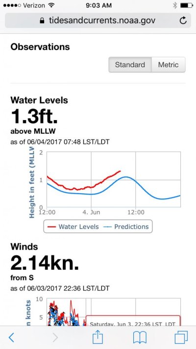
Here's one I randomly picked for Pensacola. IMG_0187.jpg . The blue is predicted. The red is observed. So you can see that today's tide will be higher than 'normal' Most places have these available. But unless it's Government provided funding often dries up and stations come and go.

Following the same usage, you can follow tide heights to confirm when predictions are made of flooding. Or extremely low water. You can see if the tide is 'doing what they predicted'. Is the tide coming in above predictions ( which would make you hit a bridge) or below allowing you to skirt under.

When is an area with lunar effected tides: How many times have you been looking out and seen rocks in an area you've never noticed them before? Extremely low tide. That means either the previous or the next high was/ will be extremely high. Using these gauges you can get real time data to see what the anticipated conditions will be. But in an area with wind driven tides both high and low will be both above or both below normal.

The key is local knowledge of how tides are effected in the local area.
 
Last edited:
Not sure you can accurately predict the variations.

For storm surges and coastal flooding, NOAA will predict as well as anyone I know.

Normal higher or lower tides from a steady wind is just a wag, better to just count on it.....winds 15 knots or greater for more than 12 hours seem to start to create higher than normal or blowout tides.


One more thing about the Indian River is that when the inland counties expect heavier than average storm water runoff, they drain the interior lakes a bit in anticipation of the upcoming storm. The result is that the Indian River water level can rise up to 18-20 inches, and if we get additional rain, then it goes up even more. Back in 2004, we have a problem with lots of people's docks floating off due to this storm water dumping.
 
First you have to realize that Tide is separate from Current. In most places high and low tide are pretty close to the change in current. When they occur in close proximity to each other it means there is no outside influences that make them different. Think rivers, estuaries, sounds, or bays. These all alter the relationship between current and tide.

Once you 'get' that there are differences between physical times of HW and LW and slack current you will learn how outside forces play into it. As mentioned wind is a huge influence on both height, and time of tide and current (both change and speed).

If you are lucky you live in a place where the time of HW and LW are coinciding with change of current. But you have to realize there are many places that they do not coincide.


Yep. FWIW, in our immediate area, there's about a 3-hour lag from high/low tide to the next slack tide. IOW, we're still on a flood for about 3 hours after nominal high tide, and it's similar with the ebb.

For OP, I often use some variation of these, one for tides and cone for current, picking different base locations for each as necessary.

https://tidesandcurrents.noaa.gov/noaatidepredictions.html?id=8575737&legacy=1
https://tidesandcurrents.noaa.gov/noaacurrents/Predictions?id=ACT4966_1

These don't speak directly to improving the predictions, but as others have said, all that other local and more immediate weather stuff applies for that.

-Chris
 
Last edited:
Another thing to be aware of is that Tampa bay and the gulf do not have the regular pattern of two highs and two lows tides as often discussed for other areas.

I have live in the bay area for a long time and without a doubt the highest water levels come with onshore winds and storms in the late summer and fall and lowest in spring especially with offshore winds.
 
One more thing about the Indian River is that when the inland counties expect heavier than average storm water runoff, they drain the interior lakes a bit in anticipation of the upcoming storm. The result is that the Indian River water level can rise up to 18-20 inches, and if we get additional rain, then it goes up even more. Back in 2004, we have a problem with lots of people's docks floating off due to this storm water dumping.

Great point...exactly why you feel out a trusted local and ask....predicting things yourself only can go so far
 
Another thing to be aware of is that Tampa bay and the gulf do not have the regular pattern of two highs and two lows tides as often discussed for other areas.

I have live in the bay area for a long time and without a doubt the highest water levels come with onshore winds and storms in the late summer and fall and lowest in spring especially with offshore winds.

Bayview,

We do have 2 highs and lows per day, usually all year round, and yes, the highs and low are affected seasonally, probably by winds, but still hard to predict with kind of accuracy.

I'm in the inter coastal, perhaps a bit different than the bay. The tide here swings about 2 to 3 feet in the summer and 3 to 4 in the winter. And often a foot or two off the prediction. I live in an area where the tide significantly affects my boating. At real low tides I can't get either boat out, but rare. But my bigger boat is hard to get out perhaps half of the time.

I'm learning how to "pre position" the bigger boat, where it's away from it's dock on into the "channel" that leads out to the inter coastal, which would help, but a real PITA. We can't all have deep water....

Folks, thx for the info....
 
I am inclined to agree with bayview...I always thought the gulf had diurnal tides. Maybe some parts are more regular...but the StPete tidal charts I just viewed looked diurnal.
 
Last edited:
Ask a specific question. Get a specific answer. https://tidesandcurrents.noaa.gov/stationhome.html?id=8726520
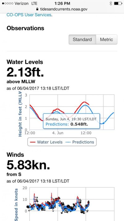
Here's a tide gauge in St Pete. Bookmark it. You can see from the 'prediction' to actual today's tide us higher than normal.

IMG_0191.jpg
Can't tell where you berth. But there's a tide gauge in Clearwater, Bradenton and Pt Manatee. The beauty of these tide gauges is they give real time info, so you can see ahead of time if the tide is going to 'meet predictions' or fall short. Or exceed heights if you have low bridge clearance to deal with as well.
 
Last edited:
Cc
 
Last edited:
I am inclined to agree with bayview...I always thought the gulf had diurnal tides. Maybe some parts are more regular...but the StPete tidal charts I just viewed looked diurnal.

Psneeld,

They are actually semi diurnal, both a bit different, but pretty close at times.
 
Ask a specific question. Get a specific answer. https://tidesandcurrents.noaa.gov/stationhome.html?id=8726520
Here's a tide gauge in St Pete. Bookmark it. You can see from the 'prediction' to actual today's tide us higher than normal.

View attachment 65409
Can't tell where you berth. But there's a tide gauge in Clearwater, Bradenton and Pt Manatee. The beauty of these tide gauges is they give real time info, so you can see ahead of time if the tide is going to 'meet predictions' or fall short. Or exceed heights if you have low bridge clearance to deal with as well.

I'm in Maderia Beach tide about a hour and a half before St. Pete. We do have Subordinate Station right in Maderia beach but does not give the actual, but does help.

This is the second web site I listed in post 1, and it's a fairly good one, but I learned a few more things about it... lots of info there.
 
Keep scrounging the net. Often local universities, research institutes install new ones (even if for a year or so) and most put their data on the net as well. Some is realtime, But depends on funding.
 
Semidiurnal is 2 highs and 2 lows except for a day or 2 a month....like the atlantic seaboard.

Pretty sure most of the gulf is diurnal. The big bend area with the most pronounced.

One website description....

Tidal Inequality. Coastal Characteristics: Tides along the Atlantic coast are generally semidiurnal with a small diurnal inequality. Tides inside the Gulf of Mexico range from semidiurnal at Key West, Florida, to diurnal at Pensacola, Florida, to mixed at Galveston, Texas.
 
Last edited:
Back
Top Bottom