Happy Summer Cruising every one...

The friendliest place on the web for anyone who enjoys boating.
If you have answers, please help by responding to the unanswered posts.

Per

Guru
Joined
Jan 25, 2011
Messages
622
I hope everyone is getting out there on their favorite spot and enjoying the water.
I finally bit the bullet and had my generator replaced, got a refurb NL 5.0 KW.
This past weekend we went to the Island (Catalina) got on a mooring and really enjoyed everything boating has to offer.

Here is a photo of our boat out there, taken early evening from the pier at The Isthmus.
 
Last edited by a moderator:
Well, six weeks out of commission beginning in June due to propeller shaft issue. Now in the middle of having a three-week period for several day trips until a two-week visit via public transportation to Germany beginning in August. Then take the boat to the yard for bottom painting and other maintenance. And then beginning in September to fulfill boat-trip promises to friends and acquaintances. Another summer mostly not boating. Good thing the boating season here is 12 months long.

Winter boating here:

232323232%7Ffp635%3C2%3Enu%3D3363%3E33%3A%3E57%3B%3EWSNRCG%3D37%3A3%3A34%3B5%3A336nu0mrj
 
Here is a photo of our boat out there, taken early evening from the pier at The Isthmus.

Hey, what are all those creatures out on the...... oh, they're other boats. Bummer.


:)
 
Last edited by a moderator:
I suppose it depends on whether you like close company.

img_95445_0_ceb7f17289de192265145cf7f8ab418a.jpg
 
While alone, still "in the middle of it all."

232323232%7Ffp73464%3Enu%3D3363%3E33%3A%3E57%3B%3EWSNRCG%3D37%3A3%3A336%3B4336nu0mrj
 
Attitude Adjustment has been underway since June 18th. Down LI Sound, up the Hudson River, Erie Canal, Oswego Canal, across Lake Ontario, Trent-Severn waterway, and currently in the Georgian Bay.
We have met so many new friends, the Canadians have been awesome, and the scenery gets better every day.
In a few weeks we will turn around and return home basically on the same route stopping in some of the places we missed.
 
The Island of Catalina have many anchorages for those who seek solitude and tranquility.
We prefer to be on a mooring where we can go ashore, buy a meal or an icecream.
It is not full commando but it is also far from marina life style, though many people have come there for generations and have some serious social hours.
The Isthmus is also called Two Harbors, on the other side of the Island is Catalina Harbor, a natural Harbour where many who seek to be further away from other mankind will moor or anchor. There are the most spectacular views.
Here is a photo of the pregnant lady. Last year there was a bald eagles nest on the lady's head or hair...
 
Last edited by a moderator:
Season in NJ is half shot-- Being half shot myself I been known to go Overboard!!!
 
Last edited by a moderator:
Attitude Adjustment has been underway since June 18th. Down LI Sound, up the Hudson River, Erie Canal, Oswego Canal, across Lake Ontario, Trent-Severn waterway, and currently in the Georgian Bay.
We have met so many new friends, the Canadians have been awesome, and the scenery gets better every day.
In a few weeks we will turn around and return home basically on the same route stopping in some of the places we missed.

On your way back through Lake Ontario... on the US side of the lake, you might want to stop at Point Breeze... we are docked there at Lake Breeze Marina. You can then stop in at Rochester - the Yacht Club is a great place to stop and then an easy leg the next day to Oswego.
 
Season in NJ is half shot-- Being half shot myself I been known to go Overboard!!!

that is exactly what i do first day on vacation when the boat is safe in the mooring, and always from the flybridge...

here is a tree for Marin, a real Catalina tree...
 
Last edited by a moderator:
here is a tree for Marin, a real Catalina tree...

Hmmm.... looks like one of those designer trees they sell in the shops on Rodeo Drive. What about trees like these? They got any of them out there? I know they do in northern California but I wonder if they meet emissions and safety requirements for southern California.


View attachment 12100


View attachment 12101
 
Last edited by a moderator:
Looks great, Per! Glad to hear you bit the bullet and solved your genset woes. Wish I was within range of Catalina. Love that place!

Might be in LGB next week. I'll PM you.

They might have lots of trees in the PNW, but apparently water under your boat is optional. No thanks!

img_95601_0_ffb0272022e979fb1e23fb0f5c68db44.jpg
 
They might have lots of trees in the PNW, but apparently water under your boat is optional. No thanks!

That's pretty funny coming from someone who boats in a place where, according to what everyone down there posts about it, the average depth is 6 inches and running aground is an every-fifteen-minute occurance. :)

When I took the photo below the depth sounder was reading just a few feet shy of 1,000 feet. Granted a lot of water goes away up here a couple of times a day. But then it all comes right back again so no worries.


View attachment 12102
 
Last edited by a moderator:
Looks great, Per! Glad to hear you bit the bullet and solved your genset woes. Wish I was within range of Catalina. Love that place!

Might be in LGB next week. I'll PM you.

They might have lots of trees in the PNW, but apparently water under your boat is optional. No thanks!

img_95611_0_ffb0272022e979fb1e23fb0f5c68db44.jpg

sounds good, i got plenty cold ones onboard.
 
What about trees like these? They got any of them out there?

View attachment 12100

View attachment 12101

no trees like that but we looked around
here we are at the USC Wrigley Ocean Science Campus, the helipad is serving the hyper-barometric chamber used to treat divers from all over California and N. Mecico.


(btw that eagle looks so cold it grew fur....)
 
Last edited by a moderator:
here are some "boats" we went by on our way through the LA and LB ports, on our way to fuel before heading to the Island.
It was a beautiful summer morning.
 
Last edited by a moderator:
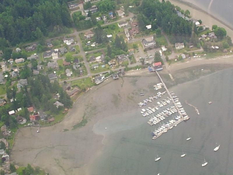
I guess if you're boating where the tides are that extreme, you need to time your trips and your slip access around low tides. That's 4 times a day of no access to your slip in a marina like this. No thanks.

While I'm here, I'll enjoy the warm waters and great climate of California with its year round boating and fishing.

For Marin, the waters and the boating environment are absolutely terrible down here. Even though you were named after California's Marin County, stay where you are. Your namesake is doing just fine without you.
 
Never heard of a marina up here yet with slip access limited by the tides. although I suppose there may be a few little ones like that. That aerial photo is more or less worthless for determining the actual depth of the water. I've spent decades looking down on this area from the plane, including places where we regularly boat, and docks can look like they're aground at low tide even though they aren't. I don't know where that photo was taken but it may well be there's only three or four feet at low tide under the innermost dock but that's probably enough to float the boats there. Our 30,000 pound GB draws 4 feet even though we operate it as though it draws six.

California. Ha. I could not be paid enough to live in California. Any of it, north or south. Or even visit. The only places I have been in the US that I find more boring geographically than the SFO bay area and SoCal are Kansas and west Texas. Every time one of you guys puts up photos of your "cruising" on the bay or off the SoCal coast I thank my departed mother for having had the good sense to get out of the place when the getting was good. Of course, she could have done a hell of a lot better than Hawaii, but at least it wasn't California. So no worries, it's all yours down there.

PS I was not named after the county although it proved handy since nobody (including me) had any problems remembering my name.:)
 
Last edited:
This beautiful gaff-rigged schooner passed us today off Benicia on its way to the Delta. From a distance it appeared to be a Junk considering the full-length battens.

img_95640_0_788b9e3d5ab9c2a74be83091b6402c91.png
 
This beautiful gaff-rigged schooner passed us today off Benicia on its way to the Delta. From a distance it appeared to be a Junk considering the full-length battens.

I see you had a little wind out there today, Mark. Hope your sail was full!
 
I guess if you're boating where the tides are that extreme, you need to time your trips and your slip access around low tides. That's 4 times a day of no access to your slip in a marina like this. No thanks.

While I'm here, I'll enjoy the warm waters and great climate of California with its year round boating and fishing.

For Marin, the waters and the boating environment are absolutely terrible down here. Even though you were named after California's Marin County, stay where you are. Your namesake is doing just fine without you.

FlyWrite I'd guess you got that picture at a -3 or-4 tide which is pretty unusual. Like Marin, I'm not convinced anybody is sitting on mud but it could be. I live and work only a few miles from this marina and I am quite familiar with it. At a minus tide the water can get pretty skinny but I believe most if not all the slips are still wet. When we do have a series of minus tides its only twice a day that the water is minus tide.

Because of the large tide changes in Budd Inlet (up to 20 feet at times) the ramps and marinas are designed to handle them. The ramp I use at Swantown Marina is Ok for me down to about a -2 tide. If it goes past that I just wait a little bit. It can get interesting on the large tide changes to get the trailer in the water just right, predicting the amount of tide change that will happen during the few minutes it takes to load the boat.

Anyways, Happy Boating to you all.
 
We are at Nanaimo tonight. Heading to Pender Harbour tomorrow,then we will push on towards desolation Sound.

We have had our daughter and granddaughter aboard for the past 10 days, so stayed in the southern Gulf islands. We caught a lot of prawns, and had a great visit (they live far away, in Paris)

If the prawns are good, we will stay north for a couple of weeks.
 
Perhaps due to isolation in the PNW.

Hmmmm.... Could be, Mark. I get so used to solitary anchorages and running for hours in the winter without seeing another recreational power boat (sailboat, maybe) and visiting little, funky, uncrowded harbors, and hearing nothing but ravens and eagles in the evening, when I see shots from other places with acres of boats crowded together or running in unbroken lines down a channel and marinas crawling with people I panic thinking what if that happens here?

Then I look at the rain and fog and gray skies and erupting volcanoes and I realize I've got nothing to worry about.:)
 
Hmmmm.... Could be, Mark. I get so used to solitary anchorages and running for hours in the winter without seeing another recreational power boat ...

Isolation is great. To a point.

img_95676_0_ab1f00d2405c59672fcc8899b7099b6c.jpg


(Trees? We don't need no stinkin' trees.)
 
Last edited:
Kearsarge Pass.... By chance named for the same Kearsarge that the Civil War frigate and the carrier were named after?
 
The reason that Vallejo marina requires periodic dredging is because we (Mark and I) are located on Mare Island Strait. The South end of MIS is the confluence of the Napa River and the Sacramento / San Joaquin Rivers. Our marina is located on the Napa River which carries a tremendous sediment load during late Winter and Spring. When the velocity of the river hits our protected marina that load drops and fills our fairways and slips quickly. It's a very dynamic region. We have to dredge every three to four years, depending on Winter precipitation. In fact, the marina has ordered dredging activity to begin in about two weeks from now. Also, and I've mentioned this before, the Sacramento and San Joaquin Rivers flow through the Carquinex Strait and into San Francisco Bay. Forty percent of all water from California (164,000 square miles) flows through the Carquinez Strait.
 
Kearsarge Pass.... By chance named for the same Kearsarge that the Civil War frigate and the carrier were named after?

Most likely. The now-gone, not-too-far-away town of Kearsarge was named after the Union man-of-war U.S.S. Kearsarge, which had sunk the Confederate ship, CSS Alabama, off the coast of France. The pass is the eastern entrance to Kings Canyon National Park.
 
I suspect most marinas or channels located near a river mouth or delta are going to have a problem with silting and require dredging from time to time. Our own marina has had a portion of one of the basins dredged this winter in conjunction with a dock replacement project. There is a high volume stream entering the bay next to the marina as well as a good sized river delta a few miles away, both of which dump a lot of silt and debris into the bay.

This is the problem with the Swinomish waterway that was mentioned earlier. The waterway connects two large and shallow bays both of which have rivers and streams dumping silt into them at a high rate. The tidal currents move this silt into the boat channel that was dredged through the slough years ago. The channel requires annual dredging but a few years ago it was stopped due to federal budget cuts. The channel silting didn't stop however, hence the problem some boaters are having today.
 

Latest posts

Back
Top Bottom