got a notice from canada coast guard today.

The friendliest place on the web for anyone who enjoys boating.
If you have answers, please help by responding to the unanswered posts.
On a different track I just decided to install a AIS transponder on the boat. In order to purchase the transponder you either had to provide an MMSI number or the Ships station license number. Since I didn't have either, I applied for an MMSI, part of the application asked if you planned to use this device in international waters. If the answer was yes, you were required to provide your ships station license.


While it might not be a source of conversation among my dock mates I don't ever remember hearing about having a ships station license for their boat. So if you are a US registered vessel, to legally use your VHF or AIS transponder in international waters you have to have an FCC issued ships station license. Admittedly my international water's boating experience is only in Canadian waters it seems like a strange requirement because who enforces it?
 
Once they us AIS for random harassment, I'm turning it off. And looks like they're doing this.

Was this event harassment? AIS tracks can be and in many cases saved by a variety of enforcement groups.

I’ve a good friend who had an onboard mechanic leave a fuel return valve in the wrong position dumping several hundred gallons of fuel in Puget Sound. Satellites noted the spill and a search of AIS targets confirmed the guilty party. Large fines resulted

As a test at our request, Marine Exchange Alaska showed us where our vessel had traveled for the previous 10 days. Welcome to the 21st century.
 
I have been aware of this area since it started, but have to agree it is not well marked. Navionics does show Vessel NO Go zone in the middle section once, but unless you magnify it to look for it, does not stand out from the other dotted lines. Like putting a tree in front of a stop sign.
CCG and Customs should work together to better advertise it to our visitors.
Whiskey Gulf is also well known, and you still have to chart a course around it.
But to leave the Bedwell custom docks you turn right into the zone.


You are correct. We checked in at Bedwell then headed north. Being new to this route i quess i perhaps got a little lazy since i was with other more experienced boats. There was discussion as to whether whiskey gulf was open. Took a bit to clear customs so we were ganging up in the bay waiting to group up. Once cleared we headed north. I got the radio call directly and since everyone monitoring heard the area was cleared so worked out for the whales.I would think the coast guard would know anyone entering these areas just didnt know and inform them so they could comply as they did with us. I was surprised to get such a letter that felt they were implying that i was somehow knowingly violating a rule. As previously noted had i been running dark perhaps one could come to a conclusion i was ignoring there rules but since i was totally transparent i wouldn't have thought i would have gotten a letter.
Makes me a little nervous thinking about running into canada next year.
 
Question, was that zone off Pender Island a voluntary do not enter at one point or was it set as a mandatory do not enter from the start? I may be getting that whale zone confused with another one but I thought it was do not enter on a voluntary basis not so long ago.
 
It has already been said that AIS is for safety. Seems to me that it worked exactly right in this case, for safety for the Orca.
You were contacted because the AIS so simplified the method to contact you, not so with the boats travelling with you. With the touch of a couple buttons or clicking on a cursor, up came your contact information. As you were unaware of the no go zone, you were politely directed to leave it. Did you get a big fat fine? No, you got a directed away from the hazard area. Are they kidding about the No-Go zone? Nope! And they sent you a letter to verify it so you know next time you are in the area. Did the letter work? Sure sounds like it did, and a whole bunch of Trawler Forum members are now wiser about these areas thanks to you, because you got that letter.

Job well done on your part! Thanks for posting.
 
Apparently, it’s not just AIS that is used to identify boats in the exclusion zone. There are land-based volunteers reported to be keeping eyes on that section of water.

Don’t bother turning off AIS, just comply with the exclusion zone as best as possible….
 
Question, was that zone off Pender Island a voluntary do not enter at one point or was it set as a mandatory do not enter from the start? I may be getting that whale zone confused with another one but I thought it was do not enter on a voluntary basis not so long ago.

I do not recall voluntary, there always was a stay so far away from whales. That area is a hot salmon fishing area, a direct transit route out of Bedwell Customs, so some bureaucrat said if we pass another law so the whales will have a safe zone and plenty of fish to eat, let humans eat farmed Atlantic salmon. (cross thread points)
 
We heard Victoria CG calling boats transiting in that zone quite a bit more this past Summer.
What amazed me was how many boats did not respond because they were not monitoring channel 16 or simply ignored the call.
That seemed to upset the CG as much as the boat being inside the zone!
I hope those boats got "the letter" as well
 
Keith
Was this exclusion zone a test. What might happen after November 30?

Tom
I haven't heard that, though it is certainly a possibility. Need to ask an Orca how well it is working.
 
Once they us AIS for random harassment, I'm turning it off. And looks like they're doing this.

We are discussion the Orca's in SW BC, Canada here. A way to keep them safe, so having AIS is a benefit if the CG can advise boaters who are unaware that their location is in a "No Go" zone. Every call I have heard from the CG has been respectful to the errant boater. There has been no hint of attitude by the CG, and nothing impolite in responses by those boaters called. Neither are those calls random.
 
On a different track I just decided to install a AIS transponder on the boat. In order to purchase the transponder you either had to provide an MMSI number or the Ships station license number. Since I didn't have either, I applied for an MMSI, part of the application asked if you planned to use this device in international waters. If the answer was yes, you were required to provide your ships station license.

While it might not be a source of conversation among my dock mates I don't ever remember hearing about having a ships station license for their boat. So if you are a US registered vessel, to legally use your VHF or AIS transponder in international waters you have to have an FCC issued ships station license. Admittedly my international water's boating experience is only in Canadian waters it seems like a strange requirement because who enforces it?


In addition, I believe that a US citizen on a US registered, or US documented vessel, using the radio in Canadian waters is required to have an FCC restricted radiotelephone license as well. Not that I've ever personally heard of any enforcement action taken , , , , , , it's still a requirement.
 
In addition, I believe that a US citizen on a US registered, or US documented vessel, using the radio in Canadian waters is required to have an FCC restricted radiotelephone license as well. Not that I've ever personally heard of any enforcement action taken , , , , , , it's still a requirement.
See it all the time. One of those rules that are not enforced on either side.
 
The enforcement folks have other means of keeping an eye on vessels that do not comply with regulations, satellite imagery, surveillance aircraft etc. Turning off AIS might work on occasion, but a lot easier, and cheaper to respect a few simple rules. And BTW, alot of the pressure on the Canadian Government to “SAVE THE WHALES” originates from south of the Canadian border…
 
1) I’m impressed with the few US boaters who are taking their own to task here instead of dumping on us bleeding heart liberals. Thank you for that.

2) The no go zones in Johnstone Strait, though still restricted, are completely different.

3) In general, the regulations covering Tofino to Campbell River, apply to all whales, with special attention given to the endangered southern resident killer whales (SRKW).

Keith
Was this exclusion zone a test. What might happen after November 30?

No test and in fact regulations were expanded or enhanced in 2022. I’m not privy to why November 30 is there, but can speculate that because historically there are few chinook salmon in those areas after November and as Keith says, no SRKW. I would expect the regulations to be in place again next year and perhaps further expanded.

There are multiple eyes on the activity, many of the authority version; CGG & RCMSAR, DFO, Parks Canada, commercial vessels, including BC Ferries, whale watching operators, Harbour Air, Helijet, volunteer on the water whale wise educators and literally hundreds of onshore observers.

As this is written, the extremely rare occasion of all 73 members of the SRKW are on the inside of Juan de Fuca Strait and since Nov. 6 have been mainly confined to Puget Sound foraging on chum salmon.
This Orca Behavior Institute video taken on Nov. 12 in Haro Strait is of a travelling L Pod consisting of all 32 members.
https://youtu.be/9bt5l3Znh-A

As an aside, 4 humpback whales have washed ashore in BC in the past month, two confirmed vessel strikes and two awaiting determination.
 
Last edited:
S2
I’m hoping that a “whale zone” map gets published with good coordinates for Southern BC waters for the next cruising season. It would also be helpful for each marina to post these maps on their message boards.

The Pender Island zone begs for coordination into the US side of Haro Strait. Whales can’t read maps.
 
Interim Sanctuary Zones
1. Saturna Island
The waters off Saturna Island bounded by a line beginning at 48°47.150'N 123°02.733'W [northern boundary of East Point (shoreline)];
then to 48°47.367'N 123°02.915'W [Tumbo Channel];
then to 48°47.617'N 123°02.483'W [northwest boundary (east of Tumbo Point)];
then to 48°47.473'N 123°01.975'W [northeast boundary (Boiling Reef)];
then to 48°46.558'N 123°03.147'W [Boundary Pass];
then to 48°46.333'N 123°03.805'W [southeast boundary];
then to 48°46.350'N 123°05.150'W [southwest boundary (Narvaez Bay)];
then to 48°46.683'N 123°05.150'W [Fiddlers Cove];
then to 48°47.150'N 123°02.733'W [northern boundary of East Point (shoreline)].

2. Pender Island
The waters off Pender Island bounded by a line
beginning at 48°45.817'N 123°19.300'W [northwest boundary];
then to 48°46.217'N 123°18.867'W [northeast boundary];
then to 48°44.167'N 123°13.917'W [southeast boundary];
then to 48°44.153'N 123°15.517'W [southwest boundary];
then to 48°45.817'N 123°19.300'W [northwest boundary].
 
And another map
No Go Zones.jpg
 
Interim Sanctuary Zones
1. Saturna Island
The waters off Saturna Island bounded by a line beginning at 48°47.150'N 123°02.733'W [northern boundary of East Point (shoreline)];
then to 48°47.367'N 123°02.915'W [Tumbo Channel];
then to 48°47.617'N 123°02.483'W [northwest boundary (east of Tumbo Point)];
then to 48°47.473'N 123°01.975'W [northeast boundary (Boiling Reef)];
then to 48°46.558'N 123°03.147'W [Boundary Pass];
then to 48°46.333'N 123°03.805'W [southeast boundary];
then to 48°46.350'N 123°05.150'W [southwest boundary (Narvaez Bay)];
then to 48°46.683'N 123°05.150'W [Fiddlers Cove];
then to 48°47.150'N 123°02.733'W [northern boundary of East Point (shoreline)].

2. Pender Island
The waters off Pender Island bounded by a line
beginning at 48°45.817'N 123°19.300'W [northwest boundary];
then to 48°46.217'N 123°18.867'W [northeast boundary];
then to 48°44.167'N 123°13.917'W [southeast boundary];
then to 48°44.153'N 123°15.517'W [southwest boundary];
then to 48°45.817'N 123°19.300'W [northwest boundary].

Here is a link to the map of the area in question.....
https://www.pac.dfo-mpo.gc.ca/fm-gp/mammals-mammiferes/whales-baleines/docs/srkw-measures-mesures-ers/2022-srkw-ers-gulf-eng.pdf
 

Attachments

  • I S A.jpg
    I S A.jpg
    155.3 KB · Views: 26
Last edited:
The whale exclusion zones, in reality, should cross the border going south towards Juan de Fuca. Whale watching boats from both sides of the border rocket through the area and hug the exclusion zones as depicted on the postings.

Then there is the major ship channel, Boundary Pass, which is less than three nm from the Pender and Saturna Island's exclusion zones and bifurcates the actual Orca travel routes. As previously noted, the Orcas have a tough life in Southern BC and Northern WA waters trying to avoid boats and ships of all sizes.

Hopefully the Orcas will develop a stronger taste for sea lions with the ever dwindling salmon stocks.

A quick search reveals no similar exclusion areas on the US side, so it is up to the individual Orca to determine where it is safe for him/her to transit the area. The Ship Traffic lanes abut the exclusion zone at East Point, and there is a "voluntary" slow speed there for those big guys. Other than that, the general rules of distance off are all that protect the whales once they leave the exclusion zones.
As for their preferred dining, the SRKW pods have developed a taste for Spring Salmon and have been noted to ignore other types of feed, but the transient pods have been seen going after the bigger species, including Sea Lions and even Humpback Whales.
 
There are many different topics within this broad main topic and before we can get into any of them we need to understand the differences between the two killer whale ecotypes in the area; mammal eaters and fish eaters. The mammal eating Bigg’s transients are roamers which can and often do, travel 100 miles in a day, in the waters between AK and CA. Fish eating residents, as the name implies, are stay-at-homes.

I the case of the southern residents (SRKW) they confine themselves to the areas of Active Pass, Rosario, Haro and Boundary Pass. Until 2015, when they began to leave the area, their movements were very predictable, daily, from April until October. The northern residents (NRKW) practice the same behavior in Johnstone Strait, July through September. The sanctuaries mentioned in Johnstone Strait are not foraging areas. Those spots have rubbing beaches where the animals enjoy relaxing social time; a practice only done by the NRKW and no other killer whale ecotype on the planet. When the NRKW go on an annual road trip south, they visit a couple of rubbing beaches on the Sunshine coast.

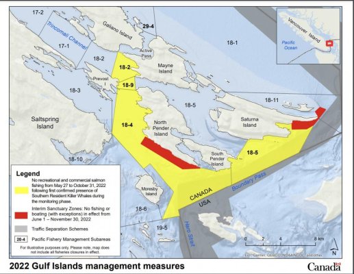
As mentioned, the overall regulations deal primarily with all whales, while the exclusionary areas are in place to protect the (currently) 73 endangered SRKW.

The two Gulf Islands exclusionary areas are not there just because any whales might be present or pass through. They are sensitive ecological areas which the SRKW have used as a sanctuary throughout their existence. It is a place where they congregate to not only forage, but to attend the day spa, where they take part in “kelping.”


The whale exclusion zones, in reality, should cross the border…
That is an issue best taken up with NOAA and there is an argument to be made for a similar exclusionary area on the west side of San Juan Island. This is an area where the SRKW, when present can spend hours on end, sometimes for days, doing what is referred to as the west side shuffle; back and forth near shore, between Snug Harbor and Eagle Point.

Hopefully the Orcas will develop a stronger taste for sea lions with the ever dwindling salmon stocks.
To be just as overly simplistic, this would take a more drastic shift than getting a vegan to switch to exclusively eating dogs.

The SRKW for 12 million years have thrived on a primary diet of chinook salmon and secondarily chum. It would take generations of change which in the end would not likely include seals and other mammals. If at all possible they might transition to expanded fish diets such as their NRKW close cousins, or to squid and sharks, which their offshore distant cousins eat.

The SRKW don’t have the physical capability to hunt marine mammals like seals, sea lions, porpoises, and other whales.

Southern residents have smaller, less robust, and dense teeth compared to their mammal-hunting cousins, the Bigg’s Killer Whales. They also evolved to have lighter jawbones suited for biting fish rather than chomping on the bones of marine mammals.

But hope is not entirely lost. There is new evidence that the Southern residents may be trying other fish on the menu that they previously have not been recorded eating. In the past few years, scientists have found the Southern Residents are dining on species such as coho salmon, halibut, and Sablefish.

Coho are much smaller and more agile than chinook, so the Southern residents are spending more energy trying to catch them than they would when they hunt Chinook. Halibut and Sablefish are deep-water species and killer whales are not famous for their diving abilities compared to other types of whales.

Every species of fish behaves differently, so the Southern residents would need to learn different techniques to catch them.

…but the transient pods have been seen going after the bigger species, including Sea Lions and even Humpback Whales.
A recent necropsy of a transient killer whale revealed a seal, sea lion and dolphin in the stomach.

Wait for it…https://youtu.be/G7WGIH35JBE
 
Last edited:
Whale watching boats from both sides of the border rocket through the area and hug the exclusion zones as depicted on the postings.

I don’t recall having ever seen whale watch boats “from both sides of the border rocket through the area and hug the exclusion zones.” Those zones are only the small red areas, not yellow as well.
 
Once they us AIS for random harassment, I'm turning it off. And looks like they're doing this.

Agree. It's a safety device that should be turned on in low visibility conditions or in scenarios where you may be in a narrow waterway unable to see oncoming traffic coming around a bend.
 
Soin, good discussion and thanks for educating us on the KW behaviors up north. I have only seen a KW pod once and it was a real treat.

There are quite a few whale watching outfits (mostly Grey and Humpbacks) that operate between San Diego and Santa Barbara. If they are doing a slow follow on a pod they will often hail other boaters on 16 and warn them to change course or slow down. It's not always successful, but they try. Another advantage of going 7Kn trawler speed.
 
Last edited:
I wonder if they are going to start enforcing all boats have combustion engines running at all times to help warn orcas your in the area. Do you think they will have electric boat ban areas as well? Super dangerous because of how silent they are.
 
I have only seen a KW pod once and it was a real treat.
Whales are something pretty new to BC people, except those who have spent their lives on the coast. Somehow “we” seem to think there is something special or extraordinary about our whale populations, but we have nothing on California.

What goes on off Monterey Bay is nothing short of spectacular. Humpbacks by the thousands, enormous rafts of sea lions, hundreds of killer whales. Plus blue, gray and minke whales, of which we only see a small percentage here on the BC coast.

The humpback whales which spend their summers between Johnstone Strait and Alaska are mostly Hawaiian, while the humpbacks south of Campbell River are mostly Mexican.

For a number of years, about a dozen regular Pacific grey whales, nicknamed the Sounders, visit the silty waters of the Snohomish River delta fattening up on ghost shrimp before continuing north to Alaska. The attached picture shows the weight gain in just 3 weeks. In 2022 several others found their way to the inside and spent the usual six weeks around southern Vancouver Island and the Sunshine Coast.

The mostly male California and stellar sea lions we have here through the summer don’t form rafts. After screwing their way through the winter, they just eat, sleep, belch and stink the place up getting ready for the next winter of fornicating without food.

Each December a small pod of California killer whales, makes the trip up to Puget Sound to visit for a few days.
 

Attachments

  • Grey B & A .jpg
    Grey B & A .jpg
    158.2 KB · Views: 20

Latest posts

Back
Top Bottom