Google Earth Question

The friendliest place on the web for anyone who enjoys boating.
If you have answers, please help by responding to the unanswered posts.

GFC

Guru
Joined
Nov 14, 2012
Messages
4,406
Location
USA
I would like to do some cruise planning and use Google Earth to chart my courses, destinations, etc. It would be nice to be able to set up layers to overlay on the main map and be able to open one or more at a time.

For example, the first layer might have the courses and destinations for the first week's cruising and saved under the name "Week 1". Similar layers could be set up for the following weeks and saved under their names.

Does anyone know if this is possible in Google Earth, and if so, how do you go about it. Please keep in mind that I'm not the most technologically gifted person on here. In fact, technologically challenged might be a better description.

So if this can be done, I'd appreciate you sharing this info with dumm ol' me.

Thanks
 
Mike - You might want to look at OpenCPN. It's an Open Source navigation program that can use both raster and vector charts. You can download the charts free from NOAA.

The program runs on Windows and maybe other operating systems (I haven't looked into that aspect). You can plot any number of routes (within reason) and waypoints. The program can connect to other devices and do route following using those devices. I can't comment on the difficulty of interfacing since I haven't tried it. You can use it "live" or print sections of charts that cover your planned routes.

Just for the fun of it, while on a big boat cruise from LA to Hawaii I set a rhumb line course and compared it with the actual course using waypoints given by the ship (one TV channel on the ship was devoted to navigation matters).

Worth a look in my opinion. Especially since the price is right (free :thumb:).
____________
Dick
 
I'm assuming you're using Google earth just for fun. With no depth info, Google earth would not be a route planning program.
 
If you use a Garmin plotter, their (now free) HomePort software is great for route planning because you are looking at marine charts while doing it. It even interfaces with Active Captain so you see the marinas, anchorages, etc. while you are planning your routes.

Best of all, you can then upload your routes to your plotter, select "day 1" and just follow the orange line.

I post this with the warning to always trust what you see with your eyes and what you hear with your ears over what's on the chart plotter. Markers may have been moved, shoaling may have developed and a barge may be anchored where your route tells you to go.
 
For my trip from Ketchikan to San Francisco I created a route on Google Maps to share with my crew and friends prior to the trip. I plotted the route in Coastal Explorer and then exported and imported it to Google Maps. After a bit of tweaking (showing alternating days in two different colors) I came up with something that works well. If you zoom in you can see every waypoint of my trip, including where I anchored.

https://www.google.com/maps/d/edit?mid=zDK21pjKavWY.kkeHjClebbys&usp=sharing

You can selectively show different routes to create the "layering" effect that you wanted.

Richard
Stillwater KK54 #5
 
Last edited:
If you use a Garmin plotter, their (now free) HomePort software is great for route planning because you are looking at marine charts while doing it. It even interfaces with Active Captain so you see the marinas, anchorages, etc. while you are planning your routes.

.

And if you have the extra cost G2 versions of the charts, you can overlay satellite imagery on the Chart data so it looks just like Google earth.
 
Thanks all for your replies and information. I'm using a Raymarine plotter so the Garmin info won't help. Also, I'm not using Google Earth (GE) for route planning, I'm using Active Captain for that. I wanted to be able to put my travels onto GE and share the course with friends who will be following our journeys from home.


I opened the OpenCPN website and will download that and see if I can get it to do what I'm looking for.


Thanks again for the tips. I may be back for more info on getting the OpenCPN and downloading the charts to work.
 
I am not sure if OpenCPN will do it, but Coastal Explorer will let you save a track as a route and then save the route as a KML file that can be opened in Google Earth. I attached one from our wanderings a couple of years ago.

Tom
 

Attachments

  • Ketchikan Sitka.kml
    404.3 KB · Views: 62
Thanks all for your replies and information. I'm using a Raymarine plotter so the Garmin info won't help. Also, I'm not using Google Earth (GE) for route planning, I'm using Active Captain for that. I wanted to be able to put my travels onto GE and share the course with friends who will be following our journeys from home.


I opened the OpenCPN website and will download that and see if I can get it to do what I'm looking for.


Thanks again for the tips. I may be back for more info on getting the OpenCPN and downloading the charts to work.

As long as you can export the route from Active Captain and import into Google Maps you can do it.

I am not sure if OpenCPN will do it, but Coastal Explorer will let you save a track as a route and then save the route as a KML file that can be opened in Google Earth. I attached one from our wanderings a couple of years ago.

Tom
Yes - I used a KML export from CE and then import into Google Maps.

Richard
 
KML, CR, GM, CPN, you guys are boggling my mind.


OK, here's where I am. I downloaded OpenCPN and got this pea green map of the US with no detail.


Then I went to the NOAA site and downloaded as bunch of charts and saved them to my hard drive.


I tried to double click on them to open them but that didn't work. I get this message asking me what I want to open them with? So, please help me out with this. I'm not an idiot but some times I feel like it when I'm trying to do this kind of stuff.


Help me Obi-wan, help me!
 
To open a chart in OpenCPN, you must first run the program. You can do that either by clicking the OpenCPN program icon on your desktop or through the Start menu. When the program is running, you will see a row of icons along the top of the program window. Click on the icon with the image of a wrench. A new window called Options will open with six icons at the top. Click on the second icon ("Charts") and the window will show some tabs. The first is "Chart Files". Click the Add Directory button on the right; this will display a file selection menu. Click on the directory that contains a chart (each chart should have its own directory). Click OK then click on the chart directory shown on the Options window. Click OK and your chart will display on the main window.

This sounds terribly complicated, but it's only about eight clicks to add a new chart. If you add several charts at once you can display the one you want to use by selecting it on the Options/Chart directory list.

If you click on the question mark icon (second from right) you can then click on the Help tab and it will pop up a browser window with the online documentation.

Hope this helps. Let us know if this gets you going.
____________
Dick
 
You can translate GE images into openCPN as charts. Google GE2KAP.

In many out of the way places, and some not so out of the way, the GE imagery is more accurately geo referenced than charts surveyed in the 1800's.
 
Who says you can't teach an OLD DOG new tricks!


I can't tell you guys how much I appreciated all of your step-by-step instructions on how to download the charts and then open them up in OpenCPN. It took awhile to get them all identified as to where they were and get them to open but the ones I downloaded are there.


I do have one two part question---when I am traveling from one area to another (for example, traveling along the Columbia River) and OpenCPN has all the charts loaded, it shows them as light and dark blue boxes along the bottom of the screen. I can select the "next" chart along the route, but it opens at a different zoom scale than then chart for the area I'm leaving.


First of all, is there a way for those charts to open automatically (seamlessly) and part 2, is there a way to get them to open at the same zoom level?


I can tell I'm going to have a lot of fun with this as I learn more about how to use it and probably will have a lot more questions. Thanks.
 
One additional question--How do I get OpenCPN to recognize and utilize the GPS that is built into my laptop?


If it can do that it would keep track of my position as we're cruising and follow the routes that I have set up.
 
OK, another question. Can Canadian charts be uploaded for use in OpenCPN?


Where do you go for those?
 
Step 1: read the User's Guide. You'll find a topic on "quilting" that will explain how to glue adjacent charts together electronically.

Step 2: I don't know what chart format(s) are in use by our northern neighbors. The User's Guide lists the formats that OpenCPN supports. Caveat: NOAA raster and vector charts are free to download. Canadian charts are not free.

Step 3: subscribe to Cruisers Forum. There's a section loaded with OpenCPN information and you can ask questions. Likely as not the answers will come from one of the developers. The search facility in the Forum is your friend.

Step 4: the User's Guide has information about using built-in GPS, but it's rather sketchy. Searching the Forum will likely be more useful.

Note that electronic raster charts are not approved for commercial navigation. Not that you are doing commercial things, just a note. Being an old dog, I prefer the electronic raster charts because they look like paper charts.

And one caution: the program defaults to true compass directions. You can switch to magnetic if you would like by using the Options.
____________
Dick
 
Last edited:
Dick, thanks for those additional comments. With the holidays coming I'm going to have to postpone spending a lot of time getting familiar with OpenCPN but I should have a lot of time afterwards.
 
After looking at the cost of Canadian ENC and Raster charts, it makes Coastal Explorer at $399 plus $99.50 for West Canada C-Map or $99 for CHS charts a good deal (annual updates are also $99) since the chart management, electronics management, and general functioning of Coastal Explorer is top drawer with most users.

Tom
 
Tom, I have a Raymarine plotter on my boat and can buy the Canadian charts on one chip for about that same amount ($99).


I was just hoping to do some pre-trip planning on OpenCPN.


Dick, I completed the first 3 steps and found a wealth of information in the CF forum user guide. I can see this is going to be a VERY time consuming search process if I work it right!


Thanks for the tips and help.
 
Yeah, you can put a lot of functionality in 100,000 lines of program code. So far I have found OpenCPN most useful for pre-plotting routes. I print the region of the chart containing one or two routes along with the waypoints and put the pages in a vinyl sheet protector. Navigation in SoCal waters isn't as "intense" as it is in other areas, so I don't have much use for the fancy stuff.

Glad I could help. If you have questions I can try to answer them, but given my limited use of the program you're probably better off posting the questions on Cruiser Forum.
____________
Dick
 
Thanks for the help. I suggested to my wife that we postpone Christmas because I had found a new boating website that needed a lot of my time.


When I woke up I was ready to be released from the hospital. All will be good in due time.


Just kidding, of course, but finding another boating site to explore is just a great Christmas present.
 
I am bumping this thread because I need some assistance from those who use Google Maps to illustrate routes.

I am continuing to research my father's service as a pilot in the RCAF in Bomber Command during WWII. I have obtained the "turning points" for about half of his operations over Germany and also to over Norway. I have figured out how to convert the latitude and longitude coordinates to KML format and can plot these on Google maps. However, I am unable to determine how to connect the waypoints in an efficient and accurate fashion. For now, I have been using the drawing tool and doing the work freehand. There has to be a better method, but I'm damned if I can figure it out, no matter how much I search the issue. Advice please?


I have attached a screen capture of the route for the bombing operation to Soest, Germany, December 5/6, 1944. The outward route is in blue and the return route is in orange.

Jim
 

Attachments

  • Dec 5 6 1944 Route Soest 1.jpg
    Dec 5 6 1944 Route Soest 1.jpg
    70.8 KB · Views: 58
I'm surprised nobody had any insights on my request above. However I have now completed putting down all 31 of the routes on Google maps and they are quite fascinating to review them and reflect back on what it would have been like to do all of this in the chaos of combat. I have had 4 phone calls with my father's navigator, still spry at 96 and with excellent recall!

I was unsuccessful in automating the "drawing feature" to connect "Turning Points" (waypoints). However I was able to come up with useful
for Great Circle Distances (Haversine formula) and also "Initial Bearings". For those who are interested...

Excel formula for Initial Bearing (True):
=ATAN2(COS(lat1)*SIN(lat2)-SIN(lat1)*COS(lat2)*COS(lon2-lon1),SIN(lon2-lon1)*COS(lat2)); where lats and longs are in radians. Note that the =radians() in excel gives a slightly different answer to latitude*22/7/180. Not sure why. Note that bearing actually changes slightly during longer distances, hence the term "initial bearing"

Excel formula for Great Circle Distances (Haversine formula):
2*ASIN(MIN(1,((SIN((Delta Latitude)/2))^2+((COS(Latitude1)*COS(Latitude2))*(SIN((Delta Longitude)/2)^2)))^0.5))*Earths radius,1)
, where Earth's radius is 6,371 km and again all coordinates in radians.

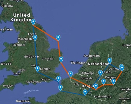
One can then concatenate the route instructions for the turning points into a "route paragraph" using some string formulas as well as the concatenate formula: Concatenate(text1,text2...). Here is a "route paragraph" for Dad's operation to Hanover, March 25, 1945:

From Base, set Course to TP2: Initial bearing 173.5 degrees T, Distance: 69.7 miles. Alter Course to TP3: Initial bearing 105.8 degrees T, Distance: 118.8 miles. Alter Course to TP4: Initial bearing 140 degrees T, Distance: 133.8 miles. Alter Course to TP5-On Track: Initial bearing 89.4 degrees T, Distance: 64.5 miles. Alter Course to TP6: Initial bearing 89.6 degrees T, Distance: 43 miles. Alter Course to TP7: Initial bearing 61.3 degrees T, Distance: 48.7 miles. Alter Course to TP8: Initial bearing 89.1 degrees T, Distance: 99.6 miles. Alter Course to TP9-On Track: Initial bearing 23.7 degrees T, Distance: 8.8 miles. Alter Course to Target Hannover: Initial bearing 23.8 degrees T, Distance: 32.9 miles. Alter Course to TP11: Initial bearing 27.4 degrees T, Distance: 6.3 miles. Alter Course to TP12: Initial bearing 304.5 degrees T, Distance: 10.2 miles. Alter Course to TP13: Initial bearing 223.7 degrees T, Distance: 68 miles. Alter Course to TP14: Initial bearing 270.6 degrees T, Distance: 64 miles. Alter Course to TP15: Initial bearing 242.1 degrees T, Distance: 48.7 miles. Alter Course to TP16: Initial bearing 271 degrees T, Distance: 107.5 miles. Alter Course to TP17: Initial bearing 321.6 degrees T, Distance: 133.8 miles. Alter Course to TP18: Initial bearing 288 degrees T, Distance: 118.8 miles. Alter Course to Middleton St George: Initial bearing 353.6 degrees T, Distance: 69.7 miles.

Note that Bomber Command was converting from MPH to Knots from late 1944 to the end of the war. As this involved replacing the "airspeed indicator" in the aircraft, not all squadrons (including dad's) completed the conversion, so I have stayed with miles for distances.

Be aware that I found computational errors in some of the web based calculators for great circle distances, and for my purposes it was best to do all of this in a spreadsheet, as I was working with hundreds of coordinates over the 31 operations.

Jim
 

Latest posts

Back
Top Bottom