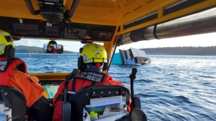
Float Home capsizes off Valdes Island.

The friendliest place on the web for anyone who enjoys boating.
If you have answers, please help by responding to the unanswered posts.
House boat was in Prolier Pass. Nasty piece of water when current opposed by wind...
The 30+ was in Boat Passage.
Going around Samuel Island via Georgeson Passage is the safe alternative
Reef was within feet of his starboard side before entering Boat Passage

Yikes, and here I thought just seeing on the charts, thinking it was narrow.

Navionics ChartViewer
 
Local knowledge is invaluable.....
 
House boat was in Prolier Pass. Nasty piece of water when current opposed by wind...
The 30+ was in Boat Passage.
Going around Samuel Island via Georgeson Passage is the safe alternative
Reef was within feet of his starboard side before entering Boat Passage


Yes. We went through the pass SE of Georgeson Is. and it was pretty straightforward. You need to keep your eye on the plotter and the depth sounder, but the position of the pass is well marked on the chart.

We’ve not gone through boat passage.

Jim
 
Roddy. That video was a great find. I have gone through 3 times so far this year on the way to Cabbage island.


Don’t be talking about Cabbage Island! We’ll be inundated with those East Coasters!
 
We’ve not gone through boat passage.
Boat Passage isn't that difficult. Rocks are easy to figure out, but also be aware of the sometimes huge kelp bed off the Saturna shore.

There are many similar and trickier spots on the coast.
 
Boat Passage isn't that difficult. Rocks are easy to figure out, but also be aware of the sometimes huge kelp bed off the Saturna shore.

There are many similar and trickier spots on the coast.
No they are not, otherwise there would be no need to keep rescuing people that have tore out their driveshaft hitting them.
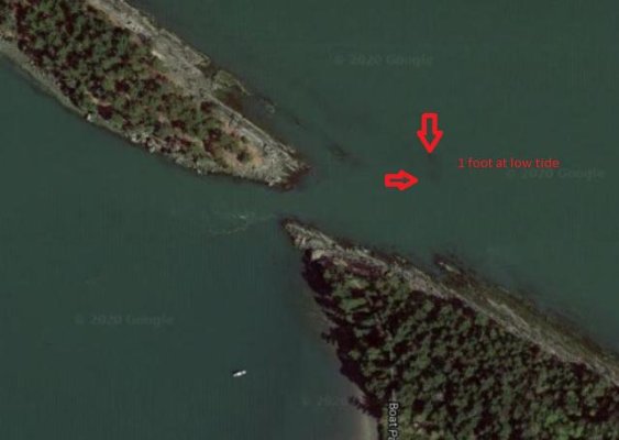
The 40 footer in the video may have known they were close. Others that approach centering the pass will find that boulder at anything but high tide.
 
I see it and know where it is. One foot below at 0 tide per chart As I said approach 'T' to opening and find that rock. Follow Shore on Saturna, line up the barn in opening.
boat pass hidden rock.jpg

Any update o the float home?
 
Still think he drifted too far starboard.
Its one thing to power through there with 10 foot beam as you have 5 feet on each side...
On 14 foot beam you've got 3 feet...
Should planned for slack or gone Georgeson
But then we wouldn't have video.
 
Still think he drifted too far starboard.
Its one thing to power through there with 10 foot beam as you have 5 feet on each side...
On 14 foot beam you've got 3 feet...
Should planned for slack or gone Georgeson
But then we wouldn't have video.

The pass is more than 20 feet wide at low tide, maybe 40, at high 60? Never has it been too narrow.
 
Why risk it? Go out the other way.
What is the risk if you following proper boating navigation. Go slow and be safe.

Hell, some people have trouble mooring their boat into their slip at the marina.
You probably know our coast is littered with unmarked below water rocks. The famous one they had to blow up in Johnston pass as everyone knew it was there and still hit it. Local knowledge or take the safer/easier route.
 
If you want to see one that's worse, not in BC but in SE AK, check out the south end of Prince of Wales island, just west of the main entrance to Nichols Bay. It's called the Burt Millar Cutoff, which supposedly is a shortcut into Nichols Bay, if can you can somehow get through the rocks and kelp, and then time the Dixon Entrance ocean swell just right. Douglass talks about it in his 'Exploring SE AK' cruising guide. I looked it at high water when we were anchored in Nichols, and I'd never attempt it, ever. Probably not even in the dinghy.
 

Latest posts

Back
Top Bottom