Do I really need paper charts?

The friendliest place on the web for anyone who enjoys boating.
If you have answers, please help by responding to the unanswered posts.
Everyone has to decide for himself what he or she wants to do. If someone does not want a paper chart that is fine, I will keep one. Perhaps it comes from my training as a pilot, I am used to doing it.
I also do take bearings along the route, plot the route I want to sail on a chart before I get the waypoints and put them into the GPS. I draw the track on a map as well, so I can see where we go, what we cross and that way I don't end up like the guys in Paxos just recently. They just pushed 'present position to A, never took a good look at the chart and completely missed a couple of rocks in the middle of the sea, so they hit it with 30 kts, boat completely destroyed. E-sysman made an episode about it.
But like I said, everyone has to decide for himself.
I just wonder if the tablet or phone is also in your grab bag in case you have to abandon ship and get into a dinghy. And how are you going to charge that phone or tablet when you sit in that dinghy ?
 
I just wonder if the tablet or phone is also in your grab bag in case you have to abandon ship and get into a dinghy. And how are you going to charge that phone or tablet when you sit in that dinghy ?

Don't think anyone is going to be doing much navigating in a dinghy. Activate the epirb. They'll find you.
 
Not everyone has your skills, nor familiarity of the water, inlets, and anchorages likely to be encountered.

Completely irrelevant.

A Raster chart on a computer is a PICTURE of a paper chart.

And where in the world does someone thinking drawing on paper and checking a route is any different than the extraordinarily easy route making on electronic charts and checking them?

All a GPS does on a chartplotters is make a little moving ship.

Maybe it's my skills that make it so clear to me that switching to electronic charts is easy peasy (no skill sets either needed or need to be changed)...maybe not forgotten is the better concept....you either have them and can apply to either paper or electronic or you don't).

If one's electronics go out, the important thingy is the GPS that feeds that little moving ship to the paper chart or the electronic chart. In today's world...most boaters have either a laptop, pad or phone ) probably all 3) that can have a complete, up to date set of charts on them....way more than a file drawer full of out of date paper ones. Plus like I said...the chances of losing all your electronics for a long period of time are very rare and maybe most should rethink their systems, systems maintenance and their MacGuyver skills.

The ONLY reason you HAVE to have paper charts is if some maritime jurisdiction requires them, your traveling partner(s) require them, or you like LOOKING at them. Other than that..... time has changed navigation tools.
 
Last edited:
This is pretty timely because it just happened to me today. I'm preparing to be a guide boat for a swim relay team swimming across Long Island Sound this weekend. Starting in Port Jefferson we are to chart a course to a particular bouy in Black Rock Harbor, Bridgeport. So in prep for that I fire up my GPS to plot the course in advance and that buoy is missing from my chart! (it's actually a tower, but still. Being puzzeled by this, I reach for my paper chart book probably 5 years old but not sure of publish date, and sure enough the buoy is there. I entered the coordinates manually and created a waypoint and named it for the buoy.

So, IMO, electronic charts are fantastic, but I would say, not always perfect.
 
Last edited:
This is pretty timely because it just happened to me today. I'm preparing to be a guide boat for a swim relay team swimming across Long Island Sound this weekend. Starting in Port Jefferson we are to chart a course to a particular bouy in Black Rock Harbor, Bridgeport. So in prep for that I fire up my GPS to plot the course in advance and that buoy is missing from my chart! Being puzzeled by this, I reach for my paper chart book probably 5 years old but not sure of publish date, and sure enough the buoy is there. I entered the coordinates manually and created a waypoint and named it for the buoy.

So, IMO, electronic charts are fantastic, but I would say, not always perfect.

That's why I like to have 2 different sources of charts on hand in unfamiliar waters. If something disagrees with what my eyes see or the 2 charts show a difference, then I know I need to figure out what's going on and what is/isn't correct. FWIW, the NOAA raster charts (which are sadly being discontinued) in electronic form are identical to the printed paper versions.
 
That's why I like to have 2 different sources of charts on hand in unfamiliar waters. If something disagrees with what my eyes see or the 2 charts show a difference, then I know I need to figure out what's going on and what is/isn't correct. FWIW, the NOAA raster charts (which are sadly being discontinued) in electronic form are identical to the printed paper versions.

I probably need to get more familar with some of the electonic versions on apps besides my Garmin MFD as backups. I'll still carry a chartbook as my cruising grounds are not that extensive, untill such time that they become too old to be useful or fall apart.
 
So in prep for that I fire up my GPS to plot the course in advance and that buoy is missing from my chart! (it's actually a tower, but still. Being puzzeled by this, I reach for my paper chart book probably 5 years old but not sure of publish date, and sure enough the buoy is there. I entered the coordinates manually and created a waypoint and named it for the buoy.

So, IMO, electronic charts are fantastic, but I would say, not always perfect.


I've seen buoys "in real life" that weren't on the raster (electronic copy of paper) charts, too.

Many of those instances would (probably) have been highlighted in LNMs... but of course LNMs don't always get transcribed onto paper... and they don't always show up on a raster copy until "the next update" is released.

Anyway, paper (or raster) charts aren't always perfect, either.


I probably need to get more familar with some of the electonic versions on apps besides my Garmin MFD as backups. I'll still carry a chartbook as my cruising grounds are not that extensive, untill such time that they become too old to be useful or fall apart.

The inexpensive MX Mariner app uses raster charts, updated relatively often.

-Chris
 
https://marinegyaan.com/what-are-ra...ed,a large number of coloured dots, or pixels.

What are RASTER Charts? Raster data is produced by scanning a paper chart. This process produces an image that is an exact replica of the paper chart and which comprises a number of lines that are composed of a large number of colored dots, or pixels.

I don't get how much simpler, less confusing or even debatable it can be.

Sure...use the wrong charts.... paper or otherwise and you get what you get. :banghead:
 
If you are wondering how to store large charts, put them under the mattress.
 
Many a person has put them under a mattress only to turn them into a moldy mess if not set up properly.
 
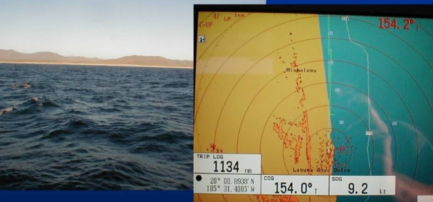
The attached pictures take a bit of study. Off the pacific coast of Mexico, about 300 nms north of Acapulco. 2004 delivery so hopefully things have changed, but I wouldn't count on it.

Left picture shows we are running a mile off the coast

Right picture is radar overlay of chart plotter. According to the chart plotter, we are on the beach. Radar overlay shows actual coastline just under 1 nm away. Datum is correct - this is an example of chart accuracy lagging electronic chart display.

With only a paper chart, you would not know there was an error. You would simply use the radar or depth sounder to maintain a desired distance off the beach.

The one thing I like about raster displays is you intuitively know when you are over-zoomed. Electronic charts scale as you zoom which often gives a false sense of accuracy.

Peter Screenshot_20220803-143328_Photos.jpg
 
I've seen buoys "in real life" that weren't on the raster (electronic copy of paper) charts, too.

Many of those instances would (probably) have been highlighted in LNMs... but of course LNMs don't always get transcribed onto paper... and they don't always show up on a raster copy until "the next update" is released.

Anyway, paper (or raster) charts aren't always perfect, either.


The inexpensive MX Mariner app uses raster charts, updated relatively often.

-Chris

I don't expect any chart to be 100% perfect, but in this particular instance, it's a lighted flashing tower on a rock pile that has been there for as long as I know, so just surprised it was missing from my charts. I almost never use paper charts unless trip planning or in an instance like this that was a little surprising.
 
Many a person has put them under a mattress only to turn them into a moldy mess if not set up properly.

Of course you need ventilation......top and bottom plus if the charts are that old, time to update the charts
 
Peter:

Fascinating example.

Back when I began cruising there were no chart plotters, at least on boats affordable to mere mortals. So it was paper, compass, depth sounder, and some dead reckoning to identifiable landmarks.

The big thing then was you KNEW you could well off in your position estimate, and so exercised appropriate caution knowing that.

Seems to me one issue today is that when folks are looking at a lot of detail including 1 ft. depth lines and sonar mapping from crowd sourcing, the level of detail brings an unspoken assumption of accuracy. And with that, over-confidence.

BandB railed on several occasions how Navionics charts could be terrific in many places, but he'd say they could get you killed in the Bahamas due to inaccuracy. That point doesn't argue for or against paper per se, but does suggest that multiple sources in unfamiliar water is a pretty good idea, especially when its cheap and readily available. Paper plus a raster image of the same paper won't get you anything extra. The point is true alternative sources. If they disagree, then best act with caution until you figure out which is accurate, if EITHER is accurate.
 
The question was "do I really need paper charts?"...the absolutely clear answer is "NO, you do not (unless required by a governing maritime organization)...but if you want them, have at it"

The trouble isn't with electronic versus paper for accuracy...the trick is to have accurate charts...they can easily be paper OR electronic these days....so pick your preference.

Navigation is like a lot of things these days...so much info you do have to be aware of what could be accurate or not...the best guard against that is GOOD experience (not the I have been boating 50 years type....but boating with lot's of varied experiences whether a few years or 50). With that experience often comes tricks and techniques necessary to stay safe. So the often extolled "they have a lot of experience....and the total time cruising is but a few years to a decade....it better be a boatload of varied experiences to actually fill that bill.
 
Last edited:
A few months ago, I posted a screen shot of a CMAP view of the breakwater protecting Ensenada. It did not show the 1/4 nm extension that was completed about 4 years ago. Brand new version of CMAP with full updates applied.

Periodically, the topic of Zone of Confidence (ZoC) for depth accuracy. Difficult information to obtain (OpenCPN is fairly easy). I think many people would be surprised at how variable the depth information is in their home waters.

Not an argument for or against paper charts. But an argument to have a healthy respect and skepticism for any single navigation source. In the end, there are only two factual data sources: radar, and depth sounder. By far, my biggest beef with chartplotters is how they are used by many: they appear much more accurate than they actually are. Rosepoint's Coastal Explorer at least flashes an "Overzoomed" warning across the screen.

That said, I do not think charts are necessary these days, but the mindset that accompanies their usage is still a good thing.

Peter
 
  • Like
Reactions: FWT
and damage control plugs are not necessary until you need them
 
and damage control plugs are not necessary until you need them

They have invented newer, better damage control items instead of wooden plugs.... like the newer invented electronic charts over paper ones.
 
They have invented newer, better damage control items instead of wooden plugs.... like the newer invented electronic charts over paper ones.
For recreational waters (vs commercial waterways with controlled depths, etc.), are ENCs really more accurate than paper charts? Are they as accurate as they appear? What's safer - a data-intensive ENC where depths are algorithmically interpolated that could easily drive over confidence in the information; or a paper chart (or equivilent) where there is no pretense about the veracity of the underlying data?

Bottom line, for recreational waters that do not have the same intensive hydrological survey data as commercial channels, ENCs may appear to be highly accurate but in reality, they are not much better than the paper/raster charts they replaced. Because the GUI is so slick, they instill a false sense of confidence which is retrograde to the intent.

Circling back to the OP, for all but passagemaking into unfamiliar waters, there is no need for paper charts. But I would caution that, for the waters folks like TFers typically navigate, the underlying data of ENCs is not nearly as accurate as it appears. Adopting a paper-chart approach to usage makes sense to me.

Peter
 
A really good chart table/shelf/area has capability to store charts flat, unfortunately... that can take up room. Also, doesn't require too much to make a skinny "flat chart" container that can be completely mobile for storage in different placements on board.

Charts layered together and quite loosely rolled are not too tough to flatten out... but due to circumference, again a room-taker! Charts tightly rolled are not much of a space occupier... but a bear to reverse roll, flatten out and actually make useable.
 
............and we are off!

My wife made me promise not to comment on this topic anymore.
~A
 
[color=[QUOTE="mvweebles, post: 1114960, member: 20942"]for recreational waters (vs commercial waterways with controlled depths, etc.), are encs really more accurate than paper charts? Are they as accurate as they appear? What's safer - a data-intensive enc where depths are algorithmically interpolated that could easily drive over confidence in the information; or a paper chart (or equivalent) where there is no pretense about the veracity of the underlying data? tools are only as good as they are made and used.... I definitely don't trust garmin/navionics/c-map, only raster or noaa enc.

bottom line, for recreational waters that do not have the same intensive hydrological survey data as commercial channels, encs may appear to be highly accurate but in reality, they are not much better than the paper/raster charts they replaced. Because the gui is so slick, they instill a false sense of confidence which is retrograde to the intent. chart depth data outside of highly travelled commercial areas isn't necessarily accurate either.

circling back to the op, for all but passagemaking into unfamiliar waters, there is no need for paper charts. But i would caution that, for the waters folks like tfers typically navigate, the underlying data of encs is not nearly as accurate as it appears. Adopting a paper-chart approach to usage makes sense to me. or raster electronic since it is exactly the same and easier to store and more convenient to be sure it is nearly up to date. Of course this is easy for us waters as they are still free, not sure of other waters.

peter[/quote]
 
Still like cruising books with their collection of charts. Have occasion to do landfalls to places we’ve never been to before with some regularity. The admiral will have the cruising guide open. We will also have the MFD(currently Simrad) up running c-maps or a different chip. Then navionics on a iPad. So have three different chart sources, magnifications and schemes of presentation. Sometimes have open up on a laptop if required to get a different chart source. I’m more interested in seeing different sources/presentations than what form of display. Don’t care IPad, chart plotter or paper. All to often there’s discrepancies between them. Also interested in where there’s good holding , absence of wakes and no swell. Want a quiet night. Although we have WaterwayGuide on the pads find paper quicker and easier and more informative. Commonly have two different guides. Find travel easy. Find where and how to stop harder.
You sometimes forget that opening screen actually applies to all charts. They are a aid to navigation. Some places they are good and accurate. But even with “notices” and crowd sourcing some places they aren’t. Think areas with active weather and large flats of sand or mud things shift around. Others areas a British admiralty chart from the 1800s will serve.
 
Last edited:
One last point of my view. I have to wonder if ,when folks think of electronic charts ,they're thinking of a MFD with a handy icon of their boat conveniently placed in the center. Not the same as thing a stand alone electronic chart with no GPS position overlaid onto it. Again, ,to me, it is way easier to plot and plan on a horizontal paper chart (vs a plotter most likely mounted vertically) with all of the ATONs ,shoreline features, spot depths, bottom composition, etc, viewable at once, whereas ,on an electronic chart, those features might or might not show up on different zoom levels.
MVYV.
 
This is an electronic chart that displayed on a pad/laptop/phone and one using the tools of free plotting software such as OpenCPN can easily plot, possibly more accurate and error free than with a pencil/dividers/parallel rules.

I am not trying to change anyone's like or dislikes, just pointing to the question "are paper charts necessary" and that chartplotters and their pros and cons and how people use them are/can be irrelevant to the basic question.

Yes, the guy who never leaves a 20 mile radius can get by nicely with a plastic fishing chart of their harbor...heck...did that for nearly 20 years as a kid fishing out of the Jersey Coast long before GPS/MFDs were ever dreamed of.

Those using paper better take care of it.... it will soon be an endangered species. And please don't consider using ENCs from any source but from NOAA and an appropriate machine to display them if you are worried about accuracy and zoom and everything else.
 

Attachments

  • chart.jpg
    chart.jpg
    116.2 KB · Views: 18
Last edited:
I guess what I am trying to describe is difference between currency and accuracy. ENCs are updated, sometimes daily, and are therefore current. That does not necessarily mean they are accurate. When I was delivering in the late 1990s/early 2000s, the most recent charts for the central California coast dated back to the 1930s. Being old does not necessarily mean they were inaccurate, especially at the wide 1:100,000 scale which forces the helmsman into other means of navigation (including lighthouses to validate DR tracklines, which I miss).

If the OPs question pertains to risk of failure of on-board GPS/navigation system either by equipment failure or global strife, the answer is relax don't worry. Risk is extremely low and options aplenty. Paper charts will do little to augment. As Psneeld noted way upthread, in the event of a failure (most common is a system lockup and a boot needed), grabbing a set of paper charts is a ways down the list of mitigation.

But if the question pertains to accuracy of underlying data compared to paper, the benefits of ENCs are not as clear. They are more easily updated and therefore more current which resolves some inaccuracies. So while an ENC may be less inaccurate than a paper counterpart, there is zero guarantee the ENC is accurate (if that makes sense). Skepticism and caution remain desirable attributes for the helmsman.

Peter
 
Let me get this straight...is the discussion about paper vs electronic charts? Or just how accurate can navigation be?

The first one to me is easily answered and probably already has been, the other is a debatable topic involving dozens/maybe hundreds of offshoot topics that dwindle into opinion as prioritizing one's needs and techniques into them can cloud the issues to the point of absurdity. Believe me, teaching navigation to multi decade professional mariners lead down more rabbit holes than I thought could exist. Just proved to me yet again how many things in life can be done different ways because of different reasons/prioritization.

A simpler argument/discussion would be whether your RADAR or plotter failure in limited visibility is a bigger liability as many boaters I have towed off sod banks/sand bars proves that relying on electronics is beyond the nav capabilities of even some pretty experienced skippers.

I agree that there are very few use-cases to carry paper charts, at least in US waters. Availability and reliability of electronic charts is extremely high (I'm including cell phone as potential backup). My concern is about depending on ENCs for accuracy vs reliability. At time of printing, an ENC and a Paper Chart (and their digitized Raster equivilent) have the identical underlying information. In my opinion, many people over-zoom their ENC displays which gives a false sense of precision which probably led to more than a few customers being towed off a grounding by someone like Psneeld.

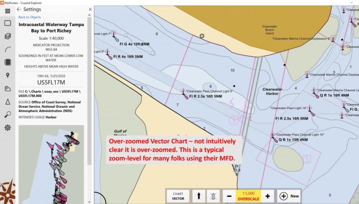
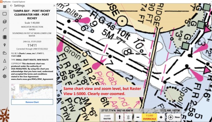
Attached are two screenshots off Coastal Explorer for exact same area of Clearwater FL entrance to ICW. Note the properties pane on the left (Vector was updated 2-months ago, Raster in 2020). These are 1:40,000 "Harbor" charts (1:40,000 is fairly coarse for a harbor chart - they can go down to 1:3000). Both pictures have been over-zoomed to 1:5000, which is probably at least what most folks run for MFD navigation so they can see the 'highway' a la Google Maps display. The Vector is great because you can easily read the ATON indicia, and all verbiage is rotated. The Raster view is heavily pixelated due to over-zoom.

To be 100% clear, the underlying data for both charts is the essentially the same (okay, there is a 2-year difference in update, doubtful much happened). But the Vector appears much, much more accurate and reliable --- it is not, it only looks that way. It's arguable the Raster is more accurate because it's an honest portrayal of the data - you know instantly it's over-zoomed and you best visually verify your position via ATONs.

So yea, a tangent to the OP's question (depending on why he asked the question). But I simply do not agree with Psneeld that this is subject to interpretation or obfuscation - the data is the data.

Peter
Vector - Clearwater.jpg

Raster - Clearwater.jpg
 
Last edited:
I can understand, I know a lot of boaters who hit the shift lever instead of the throttle first.

And like just about everything on TF, it gets complicated because of a million reasons...I prefer to keep it simple and be good at what I do. That's why I use raster electronic charts...but they are going bye bye.... so I guess we all just have to figure it out.

In my experience...looking at a paper chart while actually driving I doubt is better than knowing what a plotter is and isn't telling you. Plus, not doing your homework prior to underway and being zoomed or not at the wrong time....well what can I say to that......

Throttle lever, then shift lever...or buy a single control. Keep it simple, especially for those that don't do it for a living.
 
ENCs are updated, sometimes daily, and are therefore current.


Well... sorta...

The updated source is current, but the version in everyone's plotter may or (more usually) may not be.

Garmin, for example, appears to update their vector charts once/year (and charges $100/year for that). Furuno and Time Zero -- via MapMedia -- updates NOAA vector and raster charts once/year (no charge, don't know how long raster updates will continue). I'd guess the other makers do updates similarly?

-Chris
 

Latest posts

Back
Top Bottom