Do I really need paper charts?

The friendliest place on the web for anyone who enjoys boating.
If you have answers, please help by responding to the unanswered posts.
Recently blew the bucks for two ICW guides and the various Explorer chart books for the Bahamas. Re upped on WaterwayGuide as well. Previously did the same for the Windwards and the Leewards. Charts be they vector or raster don’t tell you a lot. Neither walk you through a landfall to a new to you harbor or country in a manner to decrease stress. Sure the information is available elsewhere. Noonsite, WaterwayGuide electronically even navionics or C-map. But find having a chart book open with guide book next to it and several charts on electronic screens is very helpful. Usually the admiral is looking at the various paper sources and reading out loud the salient points while I’m looking at screens. Maybe a belt and suspenders approach but have seen many other cruisers having the same approach. All to often youcruising a coast line having not decided where to stop or having changed our mind as to where to stop. We commonly pick a direction and go. Know this not the style of many but we are cruisers not held to a schedule. Get tired, want to fix something, decide we want to see something or the myriad reasons to change plans want to quickly learn about a potential landfall and decide if it easy, safe and enjoyable to stop there. Paper is and I suspect will always be part of the equation.
100% ageee. Love the chart books.

Noticed in another thread you're getting ready to head to Bahamas. Hope you'll keep a running TF update on progress.

Peter
 
Free electronic copies of Coast Pilots for the US often provide way more nautical info than the guides I am used to. They just lack the sightseeing stuff that I find the internet much more useful for.

Not sure what is available for other areas.....
 
Last edited:
Free electronic copies of Coast Pilots for the US often provide way more nautical info than the guides I am used to. They just lack the sightseeing stuff that I find the internet much more useful for.

Not sure what is available for other areas.....
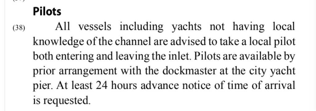
Yep, way more information in the Coast Pilot. For example, I doubt the chartpak for St Augustine includes recommendation to hire a pilot (you'll need 24 hour advance notice, and somehow find the number for the dockmaster). CP also says there are a number of yards for service, but doesn't give any specific information. More information? Yep. Useful information? Meh...

Screenshot_20220901-065038_Kindle.jpg
View attachment 131675
 
Last edited:
Commercial vessels are required to carry coast pilots, not waterway guides....

Useful info?

My guess someone else thinks there is a lot of useful navigation/safety info in them more than guide books.
 
Different programs. Do agree coast pilots are extremely useful. However, it’s not the volume of information but rather what’s useful and appropriate to you. I’ve never owned anything over 50’. I often don’t know where I’m going until I get there. Having me hire a pilot 24h before arrival ain’t going to happen too often.
Yes we plan ahead. Particularly for C&I as well as being meticulous about weather but there’s a vast difference between the cruising mindset and the commercial or governmental. Will sit with the screens on chartbooks and guides open and plan a bunch of possible stops. Will pick one as the goal. Sometimes get there sometimes not. Paper helps us in the planning stage as well as when we change plans altogether.
 
Last edited:
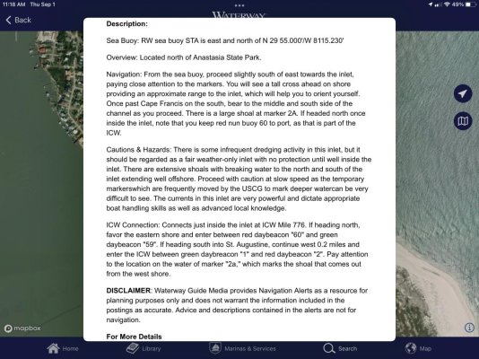
Ain’t going there!!! This from WaterwayGuide
 

Attachments

  • E068EC90-20C5-4B76-87C8-6ACC1C728656.jpg
    E068EC90-20C5-4B76-87C8-6ACC1C728656.jpg
    184.1 KB · Views: 23
Different programs. Do agree coast pilots are extremely useful. However, it’s not the volume of information but rather what’s useful and appropriate to you. I’ve never owned anything over 50’. I often don’t know where I’m going until I get there. Having me hire a pilot 24h before arrival ain’t going to happen too often.
Yes we plan ahead. Particularly for C&I as well as being meticulous about weather but there’s a vast difference between the cruising mindset and the commercial or governmental. Will sit with the screens on chartbooks and guides open and plan a bunch of possible stops. Will pick one as the goal. Sometimes get there sometimes not. Paper helps us in the planning stage as well as when we change plans altogether.

Guess that's the difference between me and maybe most here.

I see entering an unfamiliar inlet as exactly the same for any vessel, rec or commercial. Good navigation is having the info already studied before you enter and being ready for the unexpected. Many guidebooks I had described many inlets with "local knowledge only" and not much else. Even though the inlets are used by novice boaters every day and all an experienced skipper needs is a bit of ATON info, etc.....

Now as to restaurants, recreational marina facilities, sightseeing...sure guidebooks over Coast Pilots definitely.

But in my experience, internet over guidebooks hands down.

So either you look ahead at the several stops the night before (or earlier) that you "might" make when internet is available...or you have already done that months or years ahead because that's where armchair cruising pays off the most.

Unfortunately I sold all my guides and charts with my boat so I don't have any handy examples and I am just going from memory.
 
Last edited:
Ain’t going there!!! This from WaterwayGuide
If you haven't been to St Augustine, you should consider it. Really magical place. Anastasia State Park is nice by land, and thr city is near the marinas. Definitely worth a few day stop. Weather is typically calm so entrance is pretty straightforward.

Peter
 
Guess when one has a rec view, a military vessel view, a commercial view, a towing view and an instructional view... it just might be a bit different.

And yes even a delivery captain view.

I have a lot to learn too.... so your point?
 
There is a YouTube channel, well there are more than a few, with ex Navy Seals covering a variety of topics, Shaw Ryan, https://www.youtube.com/channel/UCkoujZQZatbqy4KGcgjpVxQ?app=desktop, does some very interesting interviews and is an excellent interviewer. Much better than many "professionals" I have watched or listened too over the years.

He can have some LONG interviews. The interview I am slowly working my way through at the moment is over five hours long. :eek: I can only watch 10-20 minutes at a time due to my schedule but the interview is one of the best I have ever seen about a man(Jason Redman) who has done amazing things, made amazing mistakes, yet faced up to his failures, survived those mistakes along with death, to become a better person.

The interview is this one,

What the heck does this have to do with paper charts? :lol:

Buried in the interview, is an segment were Mr. Redman is leading a team to go on a raid in a very, very dangerous city in Iraq. They are in vehicles, they have to get in and out fast. As they are the way, their electronic navigation went down. :eek: They made some wrong turns. They ended up in a even worse area where they easily could have gotten killed. They made it out after a few hairy turns and minutes.

Never again did Mr. Redman lead a mission without paper maps and photos regarding the routes and targets.

Later,
Dan
 
Guess when one has a rec view, a military vessel view, a commercial view, a towing view and an instructional view... it just might be a bit different.

And yes even a delivery captain view.

I have a lot to learn too.... so your point?

No point, just a sideways observation. But as long as you asked.....by constantly harping on your credentials as predicate to dismiss other points of view makes it seem like you think everyone else is beneath you. May not be your intent. There are many, many very experienced people on this forum, more than a few who have made their living in some form of recreational maritime activity.

Peter

Oh ....I have had enough people remind me my credentials are not important. Didn't need one more sideways reminder.

I get that.... a lifelong boater/mariner on a boat forum that thinks he has something to offer but has nothing but a resume to explain his opinions foundation.

I don't provide my credential to those that have read my posts for awhile...but for those that are new, just a reminder that some advice here is not coming from the same pool of experience.

Funny though, if I wrote magazine articles or books or did videos...I would be an automatic expert that no one would dare question. Some form of maritime employment certainly is important, but depending, it doesn't cover breadth of experience. That's why I freely admit to having to learn a lot too. If you really were worried about my "credential bragging", you would note what categories of boating I do tent to emphasize and those I almost never comment on.

As opposed to the non-maritme employed souls who are on here who have had very limited time to really study everything maritime or even just be on, above or beside the water for a lifetime.
 
Last edited:
Back
Top Bottom