seasalt007
Guru
Buy a spare set of props. That way you will never need them. I know....
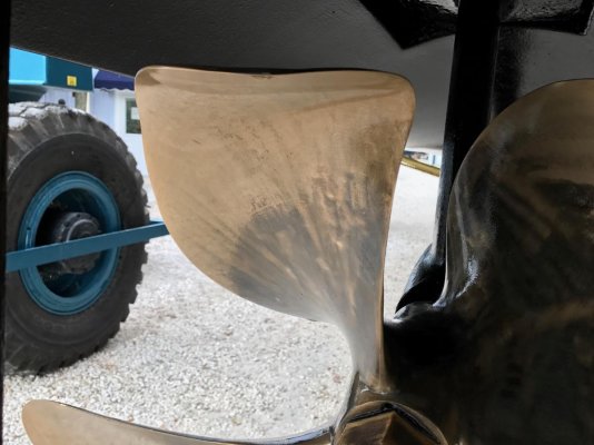
The yard sent us these pics.

Ouch. Do you think they will have you back in the water by the weekend. Right now weather looks good for a crossing. But we know how that can change.
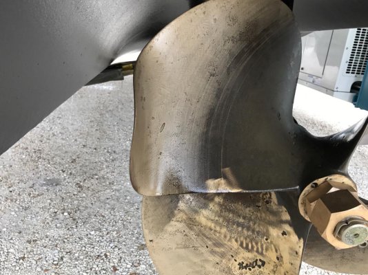
The yard sent us these pics.
A ball-peen hammer, a pair of pliers and a block of wood..........have it ready in about 20 minutes...........
That'll buff out....

Call general propeller in Bradenton and have them give you an evaluation. I’ve seen them work miracles. That starboard prop looks like it has some pitting near the hub you might want to have addressed as well.
It does have pitting. We have a brand new prop sitting in Cape Coral waiting to be shipped to us. We told them to hold off on shipping in case we need to have it shipped to Tarpon Springs instead. The seller paid to have all of the starboard running gear replaced due to some corrosion but the prop wasn’t delivered in time. They had this prop polished maybe? I forget the terms. Anyway, it was ok enough for us to get home. We will likely buy a new prop for the port side and replace both props when we get it home and then keep these as spares.
Thanks jleonard.
So far we’re getting regular updates. They said props won’t be back from the shop until the middle of next week.
As of right now, we are planning to fly back either Wednesday or Thursday depending on what the weather looks like.
As for depth instruments, David said that’s something he wants to test, but there is a depth finder gauge and then the depth on the GPS. I’m assuming they each have their own transducer? They weren’t in perfect sync, but they were pretty close to each other at all times. I am also assuming that it’s telling us how much water is under the hull. When I had my little mishap, it showed for a little bit a depth of less than a foot and we never hit bottom or ran aground.
Can’t be sure, and take internet advice cautiously from people diagnosing issues from their couch, like I am doing now, but that pitting looks more like it is cavitation based, and not galvanic which is probably a good thing. Small amounts of Cav pitting Is likely nothing to worry about, just continue to monitor at haul outs.
As of right now, we are planning to fly back either Wednesday or Thursday depending on what the weather looks like.
I’m not sure if you saw the pictures from my other thread when we did survey and haul out. There were a couple of holes in the shaft and the prop had some corrosion and pitting and the prop nut was an ugly mess. Only on starboard side.
The seller went ahead and left the boat at the yard and had the starboard running gear replaced. The new prop didn’t come in before we were ready to take the boat so they cleaned it up and polished it or whatever so that we could get the boat home. They are shipping the new prop to us.
OK Update please......