Fletcher500
Guru
This can’t be right, didn’t you see the Poseidon Adventure?
Copy, or Leonardo DeCaprio in the Titanic.
This can’t be right, didn’t you see the Poseidon Adventure?
Whenever I see discussions of forward looking sonar, I usually see some comments that it is a gimmick, you don't really need one. Others say the forward looking sonar is only good at 8 knots or less, what good is that?.
In the world of recreational trawlers, who here travels at more than 7 knots?
In the world of recreational trawlers, who here travels at more than 7 knots?
Plenty. 6.5 - 7 kts is our typical cruise, but the boat is capable of cruising at 17 kts if desired.

Bare feet don't do well on barnacles.a person needed to be carried on the beach.
Go faster at greater risk.

This is the area where the boat sank. Described as "near McBride Glacier". The shallow area at the mouth of McBride Inlet is not well surveyed. While most of Muir Inlet is deep with steep shorelines this area is not. They had attempted to enter McBride Inlet. I have taken my own boat into McBride Inlet. The entrance is narrow with strong currents and ice bergs. It is an incredible place and the glacier is much further back than what is shown on this chart. I was employed as a captain by Glacier Bay National Park for 25 years
This is the area where the boat sank. Described as "near McBride Glacier". The shallow area at the mouth of McBride Inlet is not well surveyed. While most of Muir Inlet is deep with steep shorelines this area is not. They had attempted to enter McBride Inlet. I have taken my own boat into McBride Inlet. The entrance is shallow and narrow with strong currents and ice bergs. It is an incredible place and the glacier is much further back than what is shown on this chart. I was employed as a captain by Glacier Bay National Park for 25 years
This is the area where the boat sank. Described as "near McBride Glacier". The shallow area at the mouth of McBride Inlet is not well surveyed. While most of Muir Inlet is deep with steep shorelines this area is not. They had attempted to enter McBride Inlet. I have taken my own boat into McBride Inlet. The entrance is shallow and narrow with strong currents and ice bergs. It is an incredible place and the glacier is much further back than what is shown on this chart. I was employed as a captain by Glacier Bay National Park for 25 years
Great info, thanks. As charted, definitely not a place I'd attempt to enter.

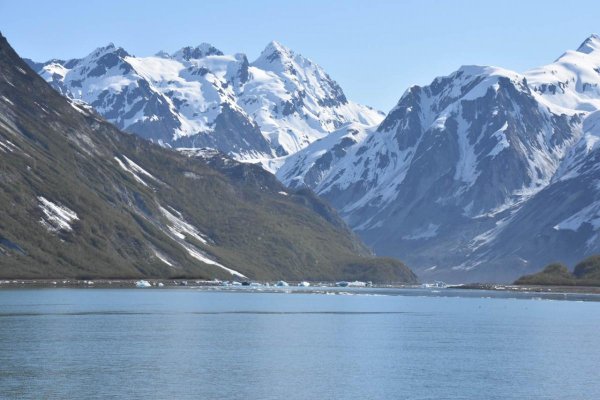
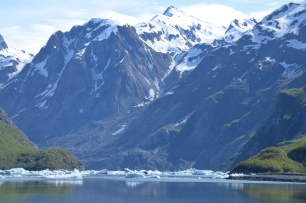
Here is what it looks like now. I heard they entered soon after low tide. When I have gone in I did it over the high tide which is scary because you are going with the current. So you and a river of ice bergs. Watch out for the ones that aren't moving, they are grounded. My boat just draws 3'. Once you get into the inlet a ways it is all deep water but the shallows at the entrance are sketchy.
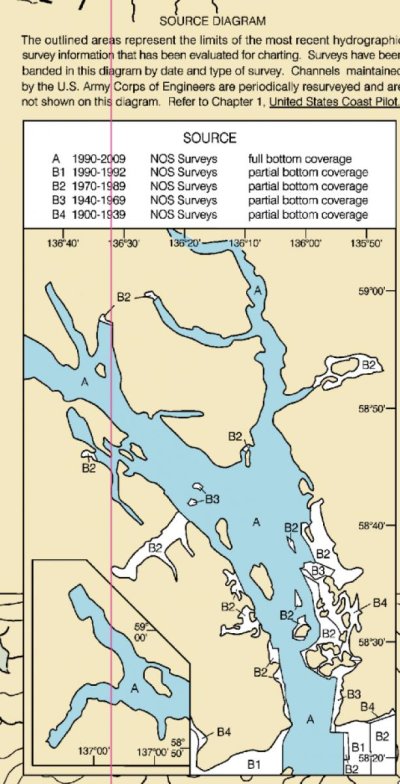
What chart is that? I "think" I have the most recent NOAA charts, but they don't show the pool beyond the bar.
The latest NOAA ENC (vector) chart does, raster charts are no longer updated. The thing I haven't found and would love to know is how to figure out when/how the soundings were done for an ENC, with good old raster charts they are listed in the corner somewhere, like the attached example.
I suspected the white object on the port side of the exposed hull was a stabilizer. Not a fan of them. Basically a rudder on the side of your hull with no skeg to protect it. The stress on that part of the hull, especially a wood hull....
Sent from my SM-G715U1 using Trawler Forum mobile app
Were the stabilizers factory installed on this Grand Banks?
And a solid core hull?
There doesn’t seem to be much recourse if you sheer one off and it opens a big hole. I’d like to think factory installed and reinforced fins aren’t as prone to this.
Any improvements in survivability of stabilizers since this boat was outfitted?
Let's just be clear that there is nothing to suggest stabilizers had anything to do with the sinking.