Autopilot and GPS heading don’t sync

The friendliest place on the web for anyone who enjoys boating.
If you have answers, please help by responding to the unanswered posts.

cardude01

Guru
Joined
Nov 26, 2012
Messages
5,290
Location
USA
Vessel Name
Bijou
Vessel Make
2008 Island Packet PY/SP
I’ve been having a strange problem lately. When I set the Raymaraine autopilot (AP) it starts off matching the GPS number heading shown on my Garnin plotter, but after a few twists and turns of the ICW the two start to veer off. Just a few degrees at first, then up to 10-20 degrees. The impact of this is my chart plotter ends up showing the boat icon going at an angle to the AP heading. Like the boat is crabbing at an angle.

I can go in manually on the AP and adjust the settings using the “seatrial wizard” so the plotter and the AP match again, but it’s a pain to have to do it ever 10 min or so, and it always ends up veering off again.

Any ideas why the two systems are not staying in sync? I have done the “swing compass” deal on my AP multiple times but that has not seemed to make a difference. I’ve checked to make sure no large metal objects are interfering with my flux gate compass. Do these compasses “go bad” after a period of time? I just googled it and came up with this, so maybe it is beginning to malfunction.

Just wondering if anyone else has experienced this problem.
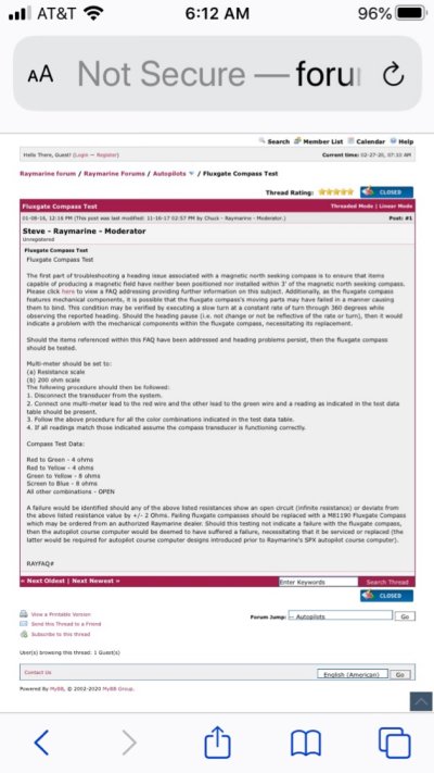
IMG_8076.JPG
 
Last edited:
Last time mine (Sitex) went fluky was because I stored a crate of canned goods too close to the compass.
Once I figured that out it was back to normal.
 
Yeah I need to double check to make sure I haven’t done the same thing. I don’t *think* I have, but maybe I’m overlooking something.
 
Just to make sure I understand, is the boat actually moving on a different course than what's shown on the chartplotter, or are the two compasses simply showing different degrees but the boat moves along the designated course?

I assume your setup for the AP is using the fluxgate compass buried somewhere in the boat - so it reads where the boat is pointed. The chartplotter uses your actual course as the boat moves through the water, regardless of which way the boat is pointed. So it is possible that current is affecting the way your vessel moves through the water and the AP is adjusting a heading that tries to compensate for that?

If you have no tidal current when this occurs - then I'm obviously off base.
 
Had the same problem. Multiple attempts circling, etc.

Mine turned out to be a failed AP compass. $98 replacement from Amazon, an hour or two mounting, re-pulling cable and all is well.

Just another data point.....
 
If you suspect the compass, a lot of them can be unbolted and slowly spun around in your hand. Watch the screen (or have someone else watch it) and see if the motion is smooth or if it hangs up somewhere.
I had a similar experience with a Furuno autopilot and the tech described the inside as having fine wires around a disk that can get screwed up.
It would be interesting to see if the problem repeated itself after several hours of going the opposite direction. North instead of south.
 
A few years ago I had a similar problem. It turned out that the 12 volt instrument power supply was borderline at times. Once I started managing on - offs better, including being careful with the microwave through the inverter, the issues settled down. If I wasn't so lazy I'd install a separate 12v instrument battery.

Dude as I gather, your problem only exist when AP in NAV position? Mine too.
 
What model Raymarine? Does it have an internal Gyro? Mine is non-gyro ST6001 and it routinely goes off track 20 degrees in the TRACK mode. Not so much in the AUTO mode which is flux-gate compass based. It used to zig-zag all over the place until I found the AUTO TRIM default setting actual caused it.


Remember the AP fluxgate and GPS heading are 2 different animals. They should agree with the boat being hand steered steady on a straight course. Make a simple table based on your magnetic compass heading and N,S,E, and W and see if the numbers are repeatable.
 
Last edited:
Had the same problem. Multiple attempts circling, etc.


Mine turned out to be a failed AP compass. $98 replacement from Amazon, an hour or two mounting, re-pulling cable and all is well.


Just another data point.....


This is what I’m suspecting also. In my initial post there is a test for the fluxgate compass so will try that. I didn’t realize it was a mechanical thing so prone to fail eventually I guess.

I’m not at the boat. Do you remember if the cable unplugged from the fluxgate so you could use the existing cable, or did you have to snake a new cable to the head unit?
 
Last edited:
It does sound like a compass going bad.

Your you AP control panel show the heading when you are manually steering too? Most do, or can depending on how they are configured. If you were to hand steer for a while, I’m wondering if the AP heading would similarly start to deviate. Or does it only happen when the AP is steering?
 
Also is the are "Factory reset" selection in one of the menus? My AP was going haywire and I got into the settings and made it worse...pretty much unuseable. I did the Factory Reset and it works perfectly now. You might try that before ripping into things.
 
It does sound like a compass going bad.

Your you AP control panel show the heading when you are manually steering too? Most do, or can depending on how they are configured. If you were to hand steer for a while, I’m wondering if the AP heading would similarly start to deviate. Or does it only happen when the AP is steering?


I’m not totally sure, but don’t think it deviates when I hand steer.
 
If this is an old problem: If your power wires going to the hydraulic pump are near the fluxgate compass, bad things will happen. Actually, any significant DC current in the area of any compass is trouble. It's possible to twist + and - wires together to minimize this.

I like the can goods story! Yes, random steel objects are trouble too. I've had to twist underdash wiring to reduce compass errors with electrical items being on.
 
It’s actually a fairly new problem, which is why I was leaning towards the fluxgate going bad.

How many wires are in that cable I wonder? Could they be spliced instead of running a new cable all the way to the head unit. For some reason the FG compass is mounted about 6-7’ from the stern, which is about 20’ from my helm.
 
This is what I’m suspecting also. In my initial post there is a test for the fluxgate compass so will try that. I didn’t realize it was a mechanical thing so prone to fail eventually I guess.

I’m not at the boat. Do you remember if the cable unplugged from the fluxgate so you could use the existing cable, or did you have to snake a new cable to the head unit?

Unfortunately, mine (Raymarine) was a fixed cable at the fluxgate compass. I even opened the unit to see if I could (re-)solder the new unit onto the old cable - it looked complicated and I also wondered if the cable itself could be contributing, so I just ran the new one. I cut the old cable and taped the new one to it to help pull it through in some of the areas. Screw terminals at the AP business-end.

IIRC there were only 4 wires to be connected at the AP.
 
Last edited:
They're not always supposed to, course and heading are different things.
 
Course and Heading are two different values, which may be the same or different depending on wind and current conditions. A GPS does not provide Heading (except GPS Compass, which uses two or three position sensors to do this). The GPS is providing Course, actually predicted course based on the track left behind. Some GPS (those for terrestrial use) actually label this value 'heading', but it is course.

Different chartplotters handle the orientation of the boat icon in different ways. Some will allow you to select whether it is oriented by heading or course when both values are available, others automatically use heading when available and don't give you the option. Usually there is also a predictor line and that is always using course. If the serial data connection between the AP and plotter is wired both ways then then the heading information from the pilot will be transmitted to the plotter and used, or can be used, for the icon orientation. It looks like this is the case in the OPs installation.

When a boat is running in any cross current or cross wind conditions there will be a discrepancy between course and heading and it can be significant. A plotter with heading-oriented icon will show the boat crabbing because it is crabbing. Along the ICW there can be significant and variable cross currents. With a pilot running in NAV mode a certain amount of cross track error will build up before it compensates and brings the boat back to the plotted track, and these corrections may also be seen as a discrepancy in steering the course. Changing cross currents will cause more significant cross track errors which result in the pilot making more significant corrections.

Anyhow, my main point is to keep in mind that heading and course can only be the same when there is no cross wind and no cross current. They will always be different otherwise, sometimes significantly. To readily visualize this, look at some videos of airplanes landing in cross winds.

Also, compass trouble always means bad steering performance. If the pilot on AUTO leaves a relatively straight line behind you through the water on all headings, don't suspect the compass. There's very little inside the Raymarine heading sensor, only windings on a weighted gimbal, all the electronics are in the processor so there's not much that can fail in there as long as the watertight integrity of it isn't compromised.
 
Cardude, if we can get the boat on your plotter to point straight all the time will we have solved your problem? There's nothing else wrong is there?
 
Last edited:
I think there are a few missing pieces of information. With out them you may windup chasing shadows. A little "process of elimination" might help.

Assumptions:

1. System has worked properly in the past?

2. The GPSMAP is working correctly with the AP turn off. Boat's heading is displayed correctly (Icon and numeric display) once the boat is underway. The GPS installation does not include a separate "heading" sensor (normally required to sync GPSMAP orientation with radar display)

3. The AP functions normally in the "Track Route" mode where the route is programmed in the GPSMAP - but the heading error between AP and GPS increases over time. (your description of the problem)

Note:

There is only one heading sensor in the system (associated with the AP). With the autopilot turned off, the heading shown on the GPS is calculated based on the changes in position. With AP turned on, heading data from the AP direction sensor is sent to the GPS over the buss and overrides the GPS's heading calculation. If the heading sensor in the AP is going bad the heading display on the GPS will likely display the bad heading data.

Most AP's have a " heading hold" function intended to hold the boat on a straight - designated "heading" in open water. If the heading sensor is going bad, the boats actual heading will drift over time and the track will not be straight.

The confusion comes from the fact that the GPS heading display data can come from either of two sources - internal calculations or from the AP sensor (compass). The AP may appear to work correctly in the "Track Route" mode even with the heading sensor going bad because the heading senor is not the prime source of the tracking error signal that the AP uses to steer the boat in that mode.

I suspect the AP's heading sensor (compass) is failing - your GPS may have a setting to ignore external heading data - turning that on will tell you for sure.

Good luck!
 
Last edited:
Cardude, if we can get the boat on your plotter to point straight all the time will we have solved your problem? There's nothing else wrong is there?


Yes! This is really my only complaint. Otherwise I think the AP is working fine. The way I use the AP is probably pretty unsophisticated. I just point the boat the way I want to go, whether on the ICW or out in open water, and hit AUTO on the Raymarine control head, and then go about my business. And again, as long as I don’t have to make big course changes on the AP (I steer using the AP up and down degree button often) it’s fine. If I just change course 1 or 2 degrees at a time the AP and GPS on the plotter stay in sync. If I hit the 10 degree button, or if I put the AP to standby and hand steer around a turn or something, the AP heading doesn’t come back to the Plotter GPS and I have to manually correct it. When it’s off like this the map on the plotter does not adjust itself correctly to the direction the boat is going so it’s very disconcerting. Is that a clue? That the map is off? Maybe I’m correcting the GPS (and thus the map orientation? ) on the AP head unit and not the actual boat heading?

Could it be that my plotter GPS position is the problem and not the fluxgate?

Sorry, I’m probably not explaining this very well.
 
Last edited:
Cardude,

It sure sounds like an AP compass issue. As a temporary work around, see if the MFD lets you select the data source for heading information. If so pick a heading source different from the compass.

One question. Are you using the NMEA 0183 interface between the MFD and AP?

Tom
 
Cardude,

It sure sounds like an AP compass issue. As a temporary work around, see if the MFD lets you select the data source for heading information. If so pick a heading source different from the compass.

One question. Are you using the NMEA 0183 interface between the MFD and AP?

Tom


Yikes, I’m not sure if it’s NMEA 0183 or something else. I didn’t wire it up.

Edit:
Just looked at old invoice when I bought the MFD and it has a Garmin NMEA 2000 starter kit and a Raymarine E22158 seatalk 1 to seatalking converter kit whatever that is.
 
It’s a Seatalk 1 to Seatalk NG converter. I have one used before I replaced the 6001 AP with an Evo2. Seatalk NG is best viewed as NMEA 2000 with a Raymarine connector. The converter makes your AP part of the NMEA 2000 network. On the Garmin MFD you should be able to tell it to use something other than the NMEA 2000 Seatalk converter as the source for heading information.

I still use the Seatalk NG converter since I use Raymarine’s wireless AP remote which is only a Seatalk 1 device. I find it strange they haven’t updated it.

Tom
 
GPS vs AP

Turn off the GPSmap. If the AP will run straight on Auto for 1 hour, then the compass in the AP is probably OK.

Raymarine requires a Seatalk to NMEA bus (N2K converter to talk to the Garmin GPSmap MFD. (so much for NMEA standards) Could be the "heading" data is not making it to the N2K buss and the MFD. May be a problem in the converter (bad connection, low voltage, defect).

If she will hold a straight course without the Garmin - somethings amiss in the signal path of the "AP Heading" from the AP to the MFD.

Is the GPS's POSITION accurate - when you return from manual? Just the "HEADING" indicator is wrong??


Yes! This is really my only complaint. Otherwise I think the AP is working fine. The way I use the AP is probably pretty unsophisticated. I just point the boat the way I want to go, whether on the ICW or out in open water, and hit AUTO on the Raymarine control head, and then go about my business. And again, as long as I don’t have to make big course changes on the AP (I steer using the AP up and down degree button often) it’s fine. If I just change course 1 or 2 degrees at a time the AP and GPS on the plotter stay in sync. If I hit the 10 degree button, or if I put the AP to standby and hand steer around a turn or something, the AP heading doesn’t come back to the Plotter GPS and I have to manually correct it. When it’s off like this the map on the plotter does not adjust itself correctly to the direction the boat is going so it’s very disconcerting. Is that a clue? That the map is off? Maybe I’m correcting the GPS (and thus the map orientation? ) on the AP head unit and not the actual boat heading?

Could it be that my plotter GPS position is the problem and not the fluxgate?

Sorry, I’m probably not explaining this very well.
 
I'm going to suggest that you change the settings on the MFD to show orientation by GPS rather than compass before you down the path of swapping out compass units. It's easily done. My recollection is that Garmin calls one heading and the other bearing. Easy to switch once you've figured out the interface. The main downside to doing this is that the orientation will be unstable when sitting still or moving very slowly. But if you can live with that and the AP holds a course your stated problem should go away.

It's possible that you have a bad compass, but it seems equally likely to me that there's some local magnetic interference. I have a ST6001 on my trawler and a more modern EV system on my sailboat, and have not been able to get either one to correct for deviation consistently. They both hold a course flawlessly though, so I haven't felt any urgency in addressing it.

In any case I'd suggest you explore the options in the MFD as your next step. When I was troubleshooting I set up two course projection lines, one based on heading and one on bearing, and could monitor the difference at a glance as long as I was underway in a current free area. There's a lot of flexibility in how your nav screens are set up, and I found it the customization possibilities educating and enlightening.
 
My recollection is that Garmin calls one heading and the other bearing.


That's Garmin thru and thru. Both terms are incorrect - should be "course" and "heading". And it's not a forking "map". It's a chart. This is part of why I just can't take Garmin seriously.
 
Ok awesome. This gives me lots of things to check when I get back to the boat.

AP holds a heading and goes straight as an arrow. Corruption of communication between AP and MFD makes sense to me now.

Thanks so much for all the help!
 
Corruption of communication between AP and MFD makes sense to me now.

To be clear, I'm not suggesting that there's a communication problem. I'm suggesting that your fluxgate compass is giving incorrect numbers in some quadrants. It's bad source data rather than bad communication. Compass deviation.

Sorry for being pedantic. I'm a geek :). But it matters for troubleshooting.

One more random thought: if you're synching the compass while on the ICW make sure you're not in any side current. That could also cause the symptoms you described. Also in currents you can't expect the heading and bearing to match. Could that explain what you were seeing?
 
No, no currents experienced when the deviation happens.

Ok on the communication issue. I guess I misunderstood.
 
You may be able to edit the NMEA sentences received at the MFD. I had to do this when setting up my laptop interface to my Furuno.
 

Latest posts

Back
Top Bottom