Autopilot and GPS heading don’t sync

The friendliest place on the web for anyone who enjoys boating.
If you have answers, please help by responding to the unanswered posts.
Same problem. I routinely (1/year?) open (without disconnecting) my Raymarine fluxgate compass and spray the small gimbals with a plastic friendly solvent - usually an electrical contact cleaner. This procedure allows the gimbals to move freely and improves performance. I do not recommend any attempt at lubrication. Tried that - unsuccessfully. Eventually I expect to replace the compass, but so far it is working.
 
That's Garmin thru and thru. Both terms are incorrect - should be "course" and "heading". And it's not a forking "map". It's a chart. This is part of why I just can't take Garmin seriously.
Agreed. I have Garmin wind instruments as well, and the user manuals and terminology really threw me. There wasn't much indication that the developers were sailors. Beyond the terminology gap some of the more sophisticated functions are a bit opaque as well.

OTOH these replaced a working Ockam system that less than 20 years ago was > $20k. The new system is better in every way, at a small fraction of the cost of its predecessor. I'm delighted at the range of capabilities the system offers. The displays are far better than I was expecting, *much* better than the raymarine AP display that I installed at the same time. I credit Garmin for bringing lots of innovation to the recreational end of the spectrum and providing decent quality stuff at relatively affordable prices.
 
That's Garmin thru and thru. Both terms are incorrect - should be "course" and "heading". And it's not a forking "map". It's a chart. This is part of why I just can't take Garmin seriously.

Not sure what Garmin plotters you guys are referring to but here's an excerpt from a GPSMAP 7212 Owner's Manual that describes setting the Navigation Chart Appearance. The terms Charts, Head/Heading and Course are clearly used here and throughout the entire manual. Maybe their terrestrial units use the terms Bearing and Map, but not the marine MFD's that I've used.
 

Attachments

  • GPSMAP 7212 Owner's Manual Excerpt.JPG
    GPSMAP 7212 Owner's Manual Excerpt.JPG
    43 KB · Views: 21
Larry, below is similar for my 942xs. You'll find the M word there. I was wrong in my recollection of their terms, as usual.

I'm in the bottom of the range. Had no complaints with my 720 but got a more current version to get a bunch of nifty new features. In general I'm impressed, but the interface and terminology reminds me that it was designed for small recreational boats. Things are dumbed down in some odd ways. But that's the market, so it shouldn't be surprising. Things could well be different in the built in series.

JF

Setting the Heading Line and Angle Markers

The heading line is an extension drawn on the map from the bow of the boat in the direction of travel. Angle markers indicate relative position from the heading or course over ground, which are helpful for casting or finding reference points.

You can show the heading line and the course over ground (COG) line on the chart.

COG is your direction of movement. Heading is the direction the bow of the boat is pointed, when a heading sensor is connected.

From a chart, select*Menu*>*Layers*>*My Vessel*>*Heading Line.

Angle Markers

If necessary, select*Source, and select an option:

To automatically use the available source, select*Auto.

To use the GPS antenna heading for COG, select*GPS Heading (COG).

To use data from a connected heading sensor, select*North Reference.

To use data from both a connected heading sensor and the GPS antenna, select*COG and Heading.

This displays both the heading line and the COG line on the chart.

Select*Display, and select an option:

Select*Distance*>*Distance, and enter the length of the line shown on the chart.

Select*Time*>*Time, and enter the time used to calculate the distance your boat will travel in the specified time at your present speed.

Parent Topic:Heading Line and Angle Markers

Copyright [emoji2398] Garmin. All rights reserved.

Previous
 
Dude,

Amazing how many people these days look at a blue sky and continue to argue that it is green!! What ever! If it runs straight in aint the compass.

I've added this $150 Heading Sensor to my NMEA 2K network as an independent source for bearing data. Needed to sync the radar display with the GPS display when swinging on the hook - no AP on board yet.

You could add the same to your system as a backup compass and use it to troubleshoot your network. OTOH a good tech could probably find the problem in less than a hour with the right equipment.

The simple solution - look at your compass (or the Sun)! Screw the electronics. It's all a hoax by the Chinese to render us all blithering idiots!


https://tinyurl.com/soefker Solid state nmea 2k bearing sensor.

:rolleyes:
 
Last edited:
Yes! This is really my only complaint. Otherwise I think the AP is working fine. The way I use the AP is probably pretty unsophisticated. I just point the boat the way I want to go, whether on the ICW or out in open water, and hit AUTO on the Raymarine control head, and then go about my business. And again, as long as I don’t have to make big course changes on the AP (I steer using the AP up and down degree button often) it’s fine. If I just change course 1 or 2 degrees at a time the AP and GPS on the plotter stay in sync. If I hit the 10 degree button, or if I put the AP to standby and hand steer around a turn or something, the AP heading doesn’t come back to the Plotter GPS and I have to manually correct it. When it’s off like this the map on the plotter does not adjust itself correctly to the direction the boat is going so it’s very disconcerting. Is that a clue? That the map is off? Maybe I’m correcting the GPS (and thus the map orientation? ) on the AP head unit and not the actual boat heading?

Could it be that my plotter GPS position is the problem and not the fluxgate?

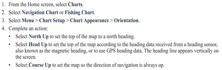
Sorry, I’m probably not explaining this very well.
did you compare the fluxgate with another magnetic compass heading?
As said before magnetic and GPS are different and will not remain the same even when both are working correctly.
Current or wind will affect the pointing of the boat (crabbing) but the GPS will keep it on plotted track.
 
GPS and fluxgate derive info in 2 different ways... and if the fluxgate and another compass dont match it shouldn't matter.

Autopilot compasses and Charplotter courses are often in disagreement and even if setup at one time will wander differently. It doesn't matter as long as the AP compass works (not necessarily be accurate) as the AP only cares if it is keeping the same mag heading, no matter what the display says.

This could all be a setting inside the charrtploter. The direction of the ships icon can usually be set to different numbers, but IIRC, often the lines point off, not the icon itself.

The one thing I can't say about your charplotter, is if it will actually show your AP heading off the fluxgate...not sure I have ever seen that.
 
Last edited:
Ok awesome. This gives me lots of things to check when I get back to the boat.

AP holds a heading and goes straight as an arrow. Corruption of communication between AP and MFD makes sense to me now.

Thanks so much for all the help!

OK - that's NOT what mine was doing when I had to replace the fluxgate compass. Mine would be going in a straight line and all of a sudden :eek::eek::eek: veer off 30 degrees to port or starboard!!!

I could just power it up sitting at the dock and watch the AP display show compass headings randomly bouncing + or - 40 degrees or more.
 

Latest posts

Back
Top Bottom