Oupss

The friendliest place on the web for anyone who enjoys boating.
If you have answers, please help by responding to the unanswered posts.
We heard the Mayday call. Three people on board were able to get into a dinghy.
 
"Janice Lee with Maritime Forces Pacific says the vessel was near Steveston when it hit the rocks.The cause of the incident is unknown, and Lee says the search and rescue has been completed."


Do those two thoughts seem contradictory?
 
"Janice Lee with Maritime Forces Pacific says the vessel was near Steveston when it hit the rocks.The cause of the incident is unknown, and Lee says the search and rescue has been completed."


Do those two thoughts seem contradictory?

News report said 3 km South of Steveston pier. Nowhere likely to find rocks, though there is a channel that distance, SE of Steveston pier. Not a popular channel, no clue where they found a rock.
 
Mainstream "news" reports of anything marine related tend to be almost as full of inaccuracies and straight out falsehoods as their reportage of military matters. Direct and bitter experience speaking here.
 
From another boating forum, by a person with local knowledge of the area:
We often go fishing in this area where the Fraser River spills into Georgia Strait. There is a breakwater that extends out to a lighthouse and when the tide is high the breakwater is awash. Apparently the navigator on this vessel tried to "cut the corner" and instead of going around the lighthouse, went between it and the breakwater. oops....
 
From another boating forum, by a person with local knowledge of the area:

Having never been in that area, but could potentially visit, I'm curious of the problem area. We have a very similar area nearby where the south end of Swinomish Channel has very similar construction, a long stretch of it has a rock breakwater that is awash at high tide, complicated in an area with a high current flow from Deception Pass toward Saratoga Passage.

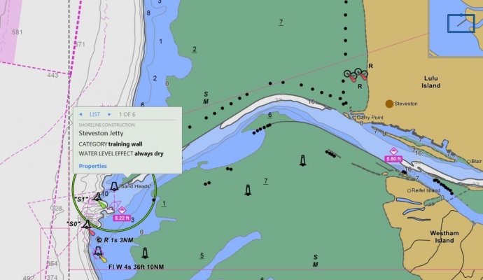
Is the area in question the end of the breakwater shown on the attached ENC? It looks like the nearest named area is Sand Heads. This would be the outlet of the Fraser closest to Steveston. (Or is the scene at the other other outlet, which I would call the north fork, that is north of the airport?)

In the attached ENC scan, I had clicked on the Jetty out near the "Sand Heads Beacon Tower" which is in between the S1 buoy and the 1A mark. Is that the area? I couldn't find any photos and google maps is blurred out there. (Odd, but I find that google maps get blurred out whenever there is something topical in the news....)

Fraser R outlet.jpg
 
From another boating forum, by a person with local knowledge of the area:

Quote:
We often go fishing in this area where the Fraser River spills into Georgia Strait. There is a breakwater that extends out to a lighthouse and when the tide is high the breakwater is awash. Apparently the navigator on this vessel tried to "cut the corner" and instead of going around the lighthouse, went between it and the breakwater. oops....
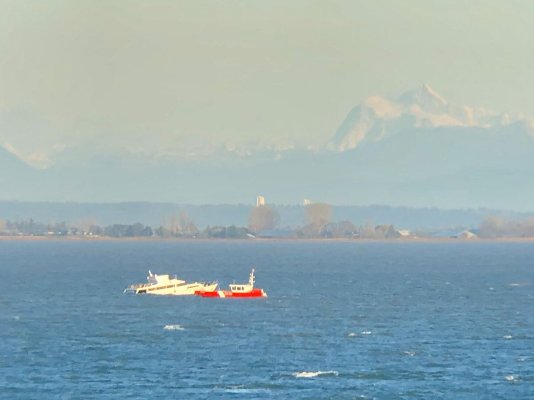
This picture shows Richmond in background, not Steveston, Vancouver airport off to the left. It looks like they cut across the rock breakwater of the Fraser instead of going around Sandheads light station, which should be to the right. They are also near the edge of the mud flats. So does look like they thought cutting through a gap in breakwater was the thing to do. If you stay in the channel there is no hidden rocks in that area.
Yauht sinks.jpg
 
Back
Top Bottom