You are using an out of date browser. It may not display this or other websites correctly.
You should upgrade or use an alternative browser.
You should upgrade or use an alternative browser.
Blaine to Anacortes
- Thread starter jimdavi
- Start date
The friendliest place on the web for anyone who enjoys boating.
If you have answers, please help by responding to the unanswered posts.
If you have answers, please help by responding to the unanswered posts.
tiltrider1
Guru
- Joined
- Aug 2, 2017
- Messages
- 4,344
- Location
- Pacific North West
- Vessel Name
- AZZURRA
- Vessel Make
- Ocean Alexander 54
3 hours or 6 hours depending on the current.
caltexflanc
Guru
You don't have any charts or a chart plotter?
gsholz
Senior Member
- Joined
- Nov 2, 2016
- Messages
- 484
- Location
- Northwest
- Vessel Make
- Sold-GB 52 Europa, Queenship 59, Tolly 45
If this is a new boat, I'd bring a laptop and USB GPS for navigation before you get your electronics installed. Coastal Explorer software is great. Even once your electronics are in, it is more convenient to create routes on the laptop vs the built-in chart plotters. And it is good to have a backup. Enjoy your new boat!
rsn48
Guru
- Joined
- Feb 18, 2019
- Messages
- 2,019
- Location
- Canada
- Vessel Name
- Capricorn
- Vessel Make
- Mariner 30 - Sedan Cruiser 1969
Knowing what I know now, I'd still have a tablet with Navionics on it, I found it much easier to use than the Lowrance that was installed on my boat, and is no longer. When you have to go in two or three menus and you are a newbie with whatever chartplotter or MFD to make adjustments, my tablet Navionics proved invaluable.
dhays
Guru
- Joined
- May 26, 2015
- Messages
- 9,045
- Location
- United States
- Vessel Name
- Kinship
- Vessel Make
- North Pacific 43
Folks, how far by water, ( trawler speed 8 its) between Blaine and Anacortes? Will be headed out Wednesday next week.
Thanks
Here is a useful link for the Salish Sea.
NWCRUISING.NET Nautical Miles in the Pacific Northwest, Olympia to Queen Charlotte Strait
Your specific route would be found here:
Nautical Miles From/To Anacortes, NOAA Chart 18400
It gives 33.6 nm and 4.8 hours at 7 knots. Since I usually cruise at 7 knots, it is really handy. The comment about current is important however as well as sea conditions along that stretch. It can be rough depending on wind and current.
rochepoint
Guru
- Joined
- Apr 4, 2009
- Messages
- 1,747
- Location
- Sidney BC, Canada
- Vessel Name
- Roche Point
- Vessel Make
- 1985 Cheer Men PT38 Sedan
Dave a little confused, the link you provided is great but when I look at it it shows the distance for Blaine to Anacortes to be 15.9 nautical miles not 33.6 nautical miles. Am i reading it wrong?
tiltrider1
Guru
- Joined
- Aug 2, 2017
- Messages
- 4,344
- Location
- Pacific North West
- Vessel Name
- AZZURRA
- Vessel Make
- Ocean Alexander 54
I am a firm believer in electronic back up. My Raymarine chart plotter is my first source. Coastal Explorer on my laptop is my second choice and navionics on my iPad is my third choice.
But from Blain to Anacortes, if you can hit it, it’s marked.
But from Blain to Anacortes, if you can hit it, it’s marked.
localboy
Senior Member
- Joined
- Sep 19, 2019
- Messages
- 450
- Location
- USA
- Vessel Name
- 'Au Kai (Ocean Traveler)
- Vessel Make
- C-Dory 25
I found this a few years ago. Very handy and the creator did a ton of work.
http://nwcruising.net/index.html
http://nwcruising.net/index.html
OP
OP
jimdavi
Senior Member
- Joined
- Aug 18, 2014
- Messages
- 466
- Location
- USA
- Vessel Name
- Couple’s Retreat
- Vessel Make
- 2019 North Pacific 45
Well, I fly up to Seattle tomorrow morning and start the first leg of bringing Couple’s Retreat home to SFO. Starting in Blaine, will go to Anacortes and then fly home. Jack DeFriel will hopefully head down the coast ~Friday depending on weather windows. I’ll track him on Garmin Inreach.
dhays
Guru
- Joined
- May 26, 2015
- Messages
- 9,045
- Location
- United States
- Vessel Name
- Kinship
- Vessel Make
- North Pacific 43
Dave a little confused, the link you provided is great but when I look at it it shows the distance for Blaine to Anacortes to be 15.9 nautical miles not 33.6 nautical miles. Am i reading it wrong?
I think you may have read the Anacortes to Bellingham line rather than the Anacortes to Blaine line. Anacortes to Bellingham is 15.9 miles.
rochepoint
Guru
- Joined
- Apr 4, 2009
- Messages
- 1,747
- Location
- Sidney BC, Canada
- Vessel Name
- Roche Point
- Vessel Make
- 1985 Cheer Men PT38 Sedan
I think you may have read the Anacortes to Bellingham line rather than the Anacortes to Blaine line. Anacortes to Bellingham is 15.9 miles.
Thanks Dave, your absolutely right.
Guess I new new glasses.........

Max Simmons
Guru
- Joined
- Oct 15, 2007
- Messages
- 805
- Vessel Make
- Ocean Alexander 38'
Am I the only one who uses Google Earth for doing quick measurement like this?
dhays
Guru
- Joined
- May 26, 2015
- Messages
- 9,045
- Location
- United States
- Vessel Name
- Kinship
- Vessel Make
- North Pacific 43
Am I the only one who uses Google Earth for doing quick measurement like this?
I’m not familiar enough with Google earth to know... can you draw a route on Google earth?
The nice thing about nwcruiser.net is that they have almost all the routes that I might be interested in and even if they don’t, I can usually take a couple and add or subtract to get the distance I’m interested in.
OP
OP
jimdavi
Senior Member
- Joined
- Aug 18, 2014
- Messages
- 466
- Location
- USA
- Vessel Name
- Couple’s Retreat
- Vessel Make
- 2019 North Pacific 45
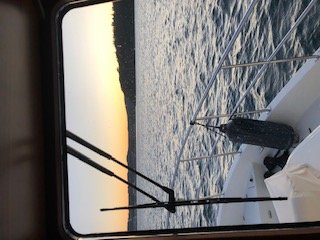
Well, had my first run with The new boat. Cruised ~2,000 ( new engine don’t baby it) at ~76% and spent a great 5 hours enjoying the Pacific Northwest. Learned much about crab pots!
Boat handled very well with no issues. Pulled into Anacortes C dock right at sunset and had dinner at Anthony’s.
Plan is for Jack to leave tomorrow and be in SFO Wednesday if weather holds.
Pic is pulling into Anacortes yesterday at sunset.
Boat handled very well with no issues. Pulled into Anacortes C dock right at sunset and had dinner at Anthony’s.
Plan is for Jack to leave tomorrow and be in SFO Wednesday if weather holds.
Pic is pulling into Anacortes yesterday at sunset.
Attachments
katherinehaynie
Newbie
You might also install Marine Traffic. It's a great way to follow fellow boaters, as well as your own boat.Well, I fly up to Seattle tomorrow morning and start the first leg of bringing Couple’s Retreat home to SFO. Starting in Blaine, will go to Anacortes and then fly home. Jack DeFriel will hopefully head down the coast ~Friday depending on weather windows. I’ll track him on Garmin Inreach.
Probably the decision is made and irreversible, but why bring that boat from the PNW to SF? There is no where to go in SF, and thousands of miles to explore in the PNW.
I grew up sailing on SF bay and still live nearby, but keep the power boat in the PNW.
I grew up sailing on SF bay and still live nearby, but keep the power boat in the PNW.
OP
OP
jimdavi
Senior Member
- Joined
- Aug 18, 2014
- Messages
- 466
- Location
- USA
- Vessel Name
- Couple’s Retreat
- Vessel Make
- 2019 North Pacific 45
Travel extensively during the week... cant imagine spending Fri/Sun flying back and forth to the boat. Just too much, although we did consider it. Hoping to go back up at some point and spend time in PNW, which I love...
OP
OP
jimdavi
Senior Member
- Joined
- Aug 18, 2014
- Messages
- 466
- Location
- USA
- Vessel Name
- Couple’s Retreat
- Vessel Make
- 2019 North Pacific 45
Too bad you can't make the trip south, would make for an informative and fun journey on your new boat. Good luck with the rest of the trip to her!
Would be great to go along south and be good experience, just can’t manage that with work schedule...
Google Earth is very easy to measure distances on, set routes on, etc. There is a ruler icon in the top row of icons. Select it, then you get to determine if you want a straight line measurement or a "path" measurement. Select path, then select how you want your measurements displayed, ie., stature miles, nautical miles, etc.I’m not familiar enough with Google earth to know... can you draw a route on Google earth?
The nice thing about nwcruiser.net is that they have almost all the routes that I might be interested in and even if they don’t, I can usually take a couple and add or subtract to get the distance I’m interested in.
Very easy and very handy.
rsn48
Guru
- Joined
- Feb 18, 2019
- Messages
- 2,019
- Location
- Canada
- Vessel Name
- Capricorn
- Vessel Make
- Mariner 30 - Sedan Cruiser 1969
Probably the decision is made and irreversible, but why bring that boat from the PNW to SF? There is no where to go in SF, and thousands of miles to explore in the PNW.
I can never figure out what people in California do on their boats. Only 8 islands or something like that and a coast line in the southern area that is pretty uninspiring. When Catalina first started their 27 sailboat line back in the 70's there was no anchor locker, no shower but yet a reasonably sized head. Catalina expected the boats to really serve as day sailors going from jetty to jetty, thus no anchor or anchor locker.
I can never figure out what people in California do on their boats. Only 8 islands or something like that and a coast line in the southern area that is pretty uninspiring. When Catalina first started their 27 sailboat line back in the 70's there was no anchor locker, no shower but yet a reasonably sized head. Catalina expected the boats to really serve as day sailors going from jetty to jetty, thus no anchor or anchor locker.
OP
OP
jimdavi
Senior Member
- Joined
- Aug 18, 2014
- Messages
- 466
- Location
- USA
- Vessel Name
- Couple’s Retreat
- Vessel Make
- 2019 North Pacific 45
The San Francisco Bay Delta watershed covers more than 75,000 square miles and includes the largest estuary on the west coasts of North and South America. It also contains the only inland delta in the world.
The watershed extends nearly 500 miles from the Cascade Range in the north to the Tehachapi Mountains in the south, and is bounded by the Sierra Mountain Range to the east and the Coast Range to the west. Nearly half of the surface water in California starts as rain or snow that falls within the watershed and flows downstream to the Pacific Ocean through the Golden Gate Strait.
In addition, the watershed provides a primary source. Countless destinations in the bay and river delta that go to both Napa and Sacramento. That’s it...