Bellingham Bay

The friendliest place on the web for anyone who enjoys boating.
If you have answers, please help by responding to the unanswered posts.

Marin

Guru
Joined
Oct 23, 2007
Messages
13,745
Location
-
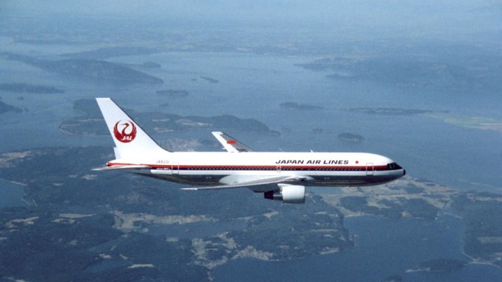
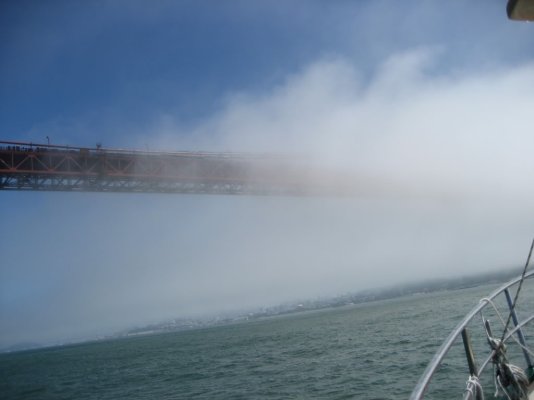
Carey and I keep our boats in Squalicum Marina in Bellingham Bay.* While going through some old film footage tonight for a video I'm producing for the delivery ceremony for Japan Airlines' first 787 I came across some air-to-air footage we took of a JAL 767 back in the 1980s. One of the scenes is of the plane as it flew over the San Juan Islands.* At one point the plane was out in front of Bellingham Bay.

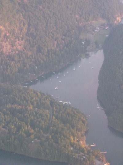
People up here know the bay well but I thought I'd grab a still from the video and put it up so poeple not familiar with the area can see what it looks like.

The bay itself is in the upper center of the frame.* Bellingham and its marina are tucked back behind the point near the head of the bay on the right side.* The large island on the left side of the bay that looks a bit like the Lock Ness monster is Lummi Island.*

If our destination is in the central or southern San Juans our first waypoint after leaving the marina is at the near end of narrow island in the mouth of the bay (it looks like two islands but what looks like a small island to the left is actually part of the same island joined by the flat section between them).* The distance from the marina entrance to this waypoint is about 8 nautical miles.

Guemes Island is the one the tail of the plane cuts over.* The harbor town of Anacortes is across the narrow channel to the south and is visible just aft of the left wing of the plane.* The largest marina in Anacortes, Cap Sante, is in the upper left corner of the bay that shows a bit above the fuselage aft of the wing.

Most of the San Juan islands lie out of frame to the left of the photo.

The prevailing winds, particularly in the winter, blow into the bay more or less from the direction marked by the airplane's nose which would be a southwest wind.* In the summer the wind often comes from the northwest.

So that's what Carey and my neck of the woods looks like.* If anyone has similar views of their neck of the woods---- particularly Dave up in Maine--- it would be neat to see them.
 

Attachments

  • jal video mstr.jpg
    jal video mstr.jpg
    113.6 KB · Views: 120
Ok, well I can't claim I took these aerial photos, but in case our neck of the boating woods is of interest to anyone, here are three shots of my marina, Horizon Shores, here near the Gold Coast, just South of Brisbane, Queensland, Australia.* I am on the finger nearest the buildings and traval-lift in the section down at the foot of the pic taken from overhead.

That almost circular vacant part has now been completely excavated and dredged so the potential marina area now extends right out to just a 50 metre land margin right across the open channel frontage, with a large number of jettys yet to be installed.* The GFC put the brakes on the development there a bit, I would say.* As you can see, it gives very quick access out to the southern part of the bay, which contains about 300 odd islands and a lot of channels.

http://www.airviewonline.com.au/index.php?cmd=catdetails&searchtext=Horizon+shores+marina&x=0&y=0

*
 
Marin:

The best I can do quickly is a Google Earth shot. The island beneath the words "North Haven" is Deer Isle. The large island to the right of the words "Blue Hill Bay" is Mt. Desert Island (home of Acadia Nat'l Park). The red arrow at the top marks Buck's Harbor, where we keep our boat. Prevailing winds in summer are SW.

Google Earth is misbehaving this morning or I would have included a couple of closer in shots as the one below does not reveal the myriad of smaller islands, particularly off the southern end of Deer Isle and on the west side of Vinalhaven I (the island just above the "13.05" in the scale at the bottom left of the shot) that provide great spots to anchor.

Okay, Google Earth just sputtered into life a bit and I have included a second shot that reveals a bit morre detail.
 

Attachments

  • penobscot bay.jpg
    penobscot bay.jpg
    183 KB · Views: 115
  • penobscot bay2.jpg
    penobscot bay2.jpg
    179 KB · Views: 118
These pictures were fun. I'll throw what I have in...

The general ATC route into SeaTac airport from the south can give a pretty good view of our marina in Tacoma*. My wife took this shot on a recent trip.

Up is relatively North (Maybe NNW?), and heads into Commencement bay and the rest of Puget Sound. Our trawler is moored on the 6th finger pier down (just north of the 2nd set of covered moorages)

Google maps link: http://g.co/maps/d2d3x
 

Attachments

  • marina_air.jpg
    marina_air.jpg
    65.9 KB · Views: 122
dwhatty wrote:The best I can do quickly is a Google Earth shot. The island beneath the words "North Haven" is Deer Isle.
*Dave--- Thanks for putting those up.* That looks like a really great boating area.* Some questions:

1. Is the water back up amongst the islands relatively protected from wind and ocean swells?* In other words, is there a similarity to your area to the inside waters of Puget Sound and BC?

2.* My impression of the bit of the Maine coast I've seen (down around Brunswick, Harpswell, Bath) is that the shores are very rocky.* If you anchor in a bay is there shore access via dinghy to walk around, take the dog, etc, or is most of the shoreline privately owned?

3.* Are there marine parks in Maine similar to what we have here in the San Juans?* In our case they are state parks usually with mooring buoys and sometimes even a float or dock.

4.* I presume recreational boaters like yourself can trap for lobsters.* Can you do this year round or is there a season like there is for Dungeness crab in our area?* Is there good lobster fishing in amongst the islands or does one have to go out into the open ocean for the best results?

I have been intrigued by the Maine coast ever since I took a car trip for a couple of days out of Boston to go up and visit the Old Town Canoe Company and an independent boatbuilder on an island on the coast who built cedar strip canoes using the West system.* At the time I had dreams of someday building a 20-foot freighter canoe and saw his ad in WoodenBoat magazine so stopped in to talk with him.* I was still living in Hawaii at the time but had already decided to move to the PNW.

Unfortunately on that trip the fog was so heavy along the coast that about all I saw of it was the centerline on the road in front of me.* But we spent a few days going and coming from PEI the other year on an island just outside Brunswick.* I rained most of the time but I got a much better idea of that part of the coast.


-- Edited by Marin on Wednesday 21st of March 2012 12:40:17 PM
 
Marin wrote:Dave--- Thanks for putting those up.* That looks like a really great boating area.* Some questions:
1. Is the water back up amongst the islands relatively protected from wind and ocean swells?* Yes, pretty protected as to swells, especially at the heads of the bays. As to wind, it depends upon the direction its coming from vs the particular island/anchorage. In other words, is there a similarity to your area to the inside waters of Puget Sound and BC? Never been to Puget Sound so can't say. Its at the top of my bucket list. My ignorant impression is that your area is a scaled up version of ours.

2.* My impression of the bit of the Maine coast I've seen (down around Brunswick, Harpswell, Bath) is that the shores are very rocky.* Yes, indeed. But lots of little pocket beaches among the rocks. If you anchor in a bay is there shore access via dinghy to walk around, take the dog, etc, or is most of the shoreline privately owned? Most of the shoreline is privately owned but around here there is a lot of it that is not built up and, especially on many of the islands, no one objects to one landing and walking the dog. We belong to MITA (even though we are not big kayakers) which gives us access to many islands. MITA puts out an annual guide that tells you what you can and cannot do on each island that is on their "trail". Some of theislands are privately owned, some owned by conservation entities and some by the State.*

A peculiarity of Maine law is that the owner of upland (i.e. land above high tide mark) is presumed to own to low water mark, unless proven otherwise. The general public is only entitled to enter onto this intertidal zone (from the sea) for the express purpose of hunting, fishing, fowling and the taking of shellfish. Period. This did not use to pose any problem to recreational use, but the acquisition of a lot of shorefront by out of staters over the last 30 years or so who jealously guard every inch of their property has restricted public recreational use of the intertidal zone, particularly in the southern part of the State.

3.* Are there marine parks in Maine similar to what we have here in the San Juans?* In our case they are state parks usually with mooring buoys and sometimes even a float or dock. Only know of one in our area that has a small float and dock as well as a couple of moorings. Also walking trails. We use it a couple of times a season.

4.* I presume recreational boaters like yourself can trap for lobsters.* You can get a recreational license for no more than 5 traps. You must be a resident, take a course and pay a fee. Cheaper, and more politic, to buy the bugs from a friend in the business.* Can you do this year round or is there a season like there is for Dungeness crab in our area?* Depends on the management zone, but most zones you can do it year round, although most fisherman haul their boats for the winter. Is there good lobster fishing in amongst the islands or does one have to go out into the open ocean for the best results? Fishing is good amongst the islands (which allows for smaller boats and investment) as well as off shore. The lobsters do migrate depending upon the season and the water temps. Maine has been enjoying record harvests for the past few years, both in pounds landed and money. Since ground fishing is all but dead, this is a boon, but the coastal fishing towns are relying upon a one species industry and things could get bad fast if something should adversely affect the critters.

I have been intrigued by the Maine coast ever since I took a car trip for a couple of days out of Boston to go up and visit the Old Town Canoe Company and an independent boatbuilder on an island on the coast who built cedar strip canoes using the West system.* At the time I had dreams of someday building a 20-foot freighter canoe and saw his ad in WoodenBoat magazine so stopped in to talk with him.* I was still living in Hawaii at the time but had already decided to move to the PNW.

Unfortunately on that trip the fog was so heavy along the coast that about all I saw of it was the centerline on the road in front of me. Those center lines have been my saviour many a time in both mother nature's and self induced fogs. But we spent a few days going and coming from PEI the other year on an island just outside Brunswick.* I rained most of the time but I got a much better idea of that part of the coast.


-- Edited by Marin on Wednesday 21st of March 2012 12:40:17 PM
*
 
Thanks very much, Dave, for that detailed reply. From the little I've seen of your area and from your description it sounds like there are a lot of similarities between there and here other than scale. One difference I see looking at Google Earth is that where we can can go almost the whole way from Puget Sound to SE Alaska behind the protection of islands, you would have to go "outside" periodically to go from "indentation" to "indentation" along your coast. Does that present any challenges or is the Atlantic fairly benign there outside of storms?

I've been intrigued by the whole northeast marine scene ever since reading (many times) "Captains Courageous" as a little boy. And our brief visit to the Maine coast a couple of summers ago served to intrigue me more. I don't knwo that we'll ever actually boat there but we do hope to visit the area again with our friends in the not-terribly-distant future. We would like to visit PEI again and also Newfoundland, too.

That's a great area you've got up there and I envy your ability to explore it by boat.
 
OK you drew me out.* You PNW guys certainly have some great scenery.* But we in the NC coast have a wonderful gem where there are no homes or anything to mess up what nature created.* Lookout Bight.
 

Attachments

  • lookoutbight.jpg
    lookoutbight.jpg
    110.7 KB · Views: 117
I appreciate seeing all of*your really cool*pictures.**Thought I might try to*return the favor.* Links are Google...* Picts mine.

SF Bay Delta Over View and good*description (8.83 MB): http://baydeltaoffice.water.ca.gov/DeltaAtlas/03-Waterways.pdf*

Many Delta locations are*just a few to several Trawler-Speed hours from SF Bay and Golden Gate Bridge to the Pacific; areas deep inside the Delta can*take up to many*hours longer.* Over 1,000 miles of winding rivers and canals with towns, cities, small bays and small islands.* Inside the Delta is mostly relatively clear fresh water that gets swimming warm in late spring, summer, and into the*fall.* Good fishing.* CA Capital Sacramento's historic Old Sac*sits deep inside the Delta, near the junction to American River - feeding clear running water from the mountains, often quite a*cool/refreshing temp throughout summer.

*

SF Bay Ariel Photo: http://upload.wikimedia.org/wikipedia/commons/d/d2/San_Francisco_Bay_aerial_view.jpg

Golden Gate Bridge heading to Pacific at picture bottom, Alcatraz Island in center.* City of Oakland upper center.* Bay Bridge upper right.* Left out of picture's view*goes toward rest of Bay that heads into SF Delta.

*

One*thumb nail pict is Linda and me on our Tolly's FB*coming toward SF Bay through the GG Bridge.* Same day Tom Perkins brought his $189M*high tech*Maltese Falcon three mast,*square-rig sail-boat/pleasure-ship*to SF Bay on a fund raiser mission. Visit:

Another pict is our Tolly at rest, nosed up against tule at an*island edge*during a restful Delta weekend.* Rear of boat is 19' deep water*for swmming and play.**

We usually dock in the Delta's City of*Stockton - thus the covered berth pict.**

*
 

Attachments

  • copy of art & linda on to - maltese falcon sf bay entry spring 2009_100_1391.jpg
    copy of art & linda on to - maltese falcon sf bay entry spring 2009_100_1391.jpg
    68.1 KB · Views: 113
  • downsize_copy of to in delta tules 100_0429.jpg
    downsize_copy of to in delta tules 100_0429.jpg
    58.4 KB · Views: 116
  • to in delta slip 100_0416.jpg
    to in delta slip 100_0416.jpg
    59.4 KB · Views: 123
GG bridge on a more human scale.
 

Attachments

  • whispy gate.jpg
    whispy gate.jpg
    69.6 KB · Views: 133
I have just come back from a trip to BC, first time in Canada, which I assume is part of the PNW, and fell in love with the place. Looks like a wonderful boating enviroment.

After reading Dave's description of his piece of paradise it makes you realise what glorious boating waters there are. Woody's 'Lookout Bight' a case in point.


-- Edited by Andy G on Thursday 22nd of March 2012 12:09:20 AM
 
Never gave it much thought, Andy... Perhaps Canada refers to the region as the Pacific Southwest...!
 
My home port is Boot Cove, Saturna Island, BC. The photo was taken on an Air Canada puddlejump between Victoria and Vancouver. The heel of the boot (left side) and toe of the boot (top) dry to mudflats*at low tide. We live near the toe but alas not quite waterfront. Never any waves in the cove but the wind sometimes*whistles through especially winter sou'easters. Last week, three boats dragged moorings and a couple broke away in a blow with 110kph (65mph) winds. Ferries were cancelled and we were without power for 14 hours. Guess nowhere is perfect...*
 

Attachments

  • img_0315.jpg
    img_0315.jpg
    81.9 KB · Views: 122
In late May I'll be going on the fifth (or is it the sixth?) cruise to the PNW.* So far, it has been cheaper and presumably far* more comfortable via cruise ship.* Sailing among mountains is enchanting.

232323232%7Ffp53842%3Enu%3D3363%3E33%3A%3E57%3B%3EWSNRCG%3D34%3B2%3A286%3B8336nu0mrj


(Endicott Arm)


-- Edited by markpierce on Thursday 22nd of March 2012 01:13:11 AM
 
Andy G wrote:
*

I have just come back from a trip to BC, first time in Canada, which I assume is part of the PNW,
*

Technically speaking, the term Pacific Northwest is usually used to refer to the northwest corner of the US. So Oregon and Washington although some people include Idaho, too.

The BC coast goes by several names but Pacific Northwest usually isn't one of them since their coast is not "northwest" but just "west." So "BC coast," "BC west coast," "west coast BC," "central coast," "west coast Vancouver Island," and so on are the terms I've heard most often.

My favorite term for the BC coast is "BC Raincoast." I first saw this term in print in a terrific series of books called the "Raincoast Chronicles." I have all four hardbound editions and they are a fantastic collection of stories and a few poems about life along the BC coast. The time period covered is from the early 1900s on up through relatively modern times. There will be a story about the huge Martin Mars flying boat fire bombers on Vancouver Island, and the next story will be told by a fellow who was a gypo logger up the coast somewhere.

Raincoast" conjurs up exactly the right image of the area in my mind, so that is the term I use all the time now. One thing my wife and I learned as we started to fly the Beaver back and forth between Seattle and SE Alaska is that the farther north you go, the better it all gets. If you think the San Juans are nice, the Gulfs are better.* If you think the Gulfs are nice, Desolation Sound is better.* If you think Desolation Sound is nice, the jungles are better.* And so on right on up the coast to Alaska.

So the moral of the story is go north, never south :)


-- Edited by Marin on Thursday 22nd of March 2012 03:08:39 AM
 
Marin wrote:One difference I see looking at Google Earth is that where we can can go almost the whole way from Puget Sound to SE Alaska behind the protection of islands, you would have to go "outside" periodically to go from "indentation" to "indentation" along your coast. Does that present any challenges or is the Atlantic fairly benign there outside of storms?
Yes, we do have to go outside from some bays to get to others and it can present challenges if one is caught out. One picks one's window, but sometimes it can get nasty. It did to us coming down from Roque Island two years ago (which is aways eastward from Deer Isle). Following seas building to 4-6' on top of swells and winds up to 30 with pouring rain by the time we were able to shelter in Northeast Harbor on Mt. Desert. I'm sure that many of us have been in similar, if not worse, conditions, but it was the limit of my comfort level in this boat. And, of course, there is the added potential danger of catching a lobster buoy in the prop.
 
<table><tbody><tr><td style="vertical-align:bottom;">*</td><td>Reply*Quote*
</td></tr><tr><td style="width:100%;" colspan="2">
Marin wrote:
The BC coast goes by several names but Pacific Northwest usually isn't one of them since their coast is not "northwest" but just "west." So "BC coast," "BC west coast," "west coast BC," "central coast," "west coast Vancouver Island," and so on are the terms I've heard most often.

My favorite term for the BC coast is "BC Raincoast." I first saw this term in print in a terrific series of books called the "Raincoast Chronicles." I have all four hardbound editions and they are a fantastic collection of stories and a few poems about life along the BC coast. The time period covered is from the early 1900s on up through relatively modern times. There will be a story about the huge Martin Mars flying boat fire bombers on Vancouver Island, and the next story will be told by a fellow who was a gypo logger up the coast somewhere.

Raincoast" conjurs up exactly the right image of the area in my mind, so that is the term I use all the time now. One thing my wife and I learned as we started to fly the Beaver back and forth between Seattle and SE Alaska is that the farther north you go, the better it all gets. If you think the San Juans are nice, the Gulfs are better.* If you think the Gulfs are nice, Desolation Sound is better.* If you think Desolation Sound is nice, the jungles are better.* And so on right on up the coast to Alaska.

So the moral of the story is go north, never south
smile.gif


</td></tr></tbody></table>
I speak only as a native of the Southwest corner of BC.

We don't usually refer to anywhere but the US NW corner as the PNW.* To us in BC, our home waters are just "home".* We tend to get specific, as to the Southern Gulf Islands, Northern Gulf islands, Desolation Sound, the Broughtons, the Central Coast, the West Coast of Vancouver Island, The Charlottes, aka Haida Gwai.*

The Raincoast is not a term that has gained a lot of traction, but only refers to the "Central Coast", north of Cape Caution, up as far as the Alaska Border.

For us, going south is also an option, to cruise what we call the PNW.
 
koliver wrote:<table><tbody><tr><td style="vertical-align:bottom;">*</td><td>*</td></tr><tr><td style="width:100%;" colspan="2">*</td></tr></tbody></table>
The Raincoast is not a term that has gained a lot of traction, but only refers to the "Central Coast", north of Cape Caution, up as far as the Alaska Border.
*Interesting.* The Raincoast Chronicles speak of the term applying to the entire BC coast although they generally use it when talking about the region from Campbell River/Powell River north.
 

Latest posts

Back
Top Bottom