You are using an out of date browser. It may not display this or other websites correctly.
You should upgrade or use an alternative browser.
You should upgrade or use an alternative browser.
Where is the best place to anchor at Lake Worth?
- Thread starter cardude01
- Start date
The friendliest place on the web for anyone who enjoys boating.
If you have answers, please help by responding to the unanswered posts.
If you have answers, please help by responding to the unanswered posts.
RT Firefly
Enigma
Greetings,
Mr. cd. I don't know that area at all BUT it may be to your benefit to head for a more southerly point of departure so you won't be bucking the Gulf Stream the whole way. Ft. Lauderdale or Miami perhaps?
Mr. cd. I don't know that area at all BUT it may be to your benefit to head for a more southerly point of departure so you won't be bucking the Gulf Stream the whole way. Ft. Lauderdale or Miami perhaps?
Ski in NC
Technical Guru
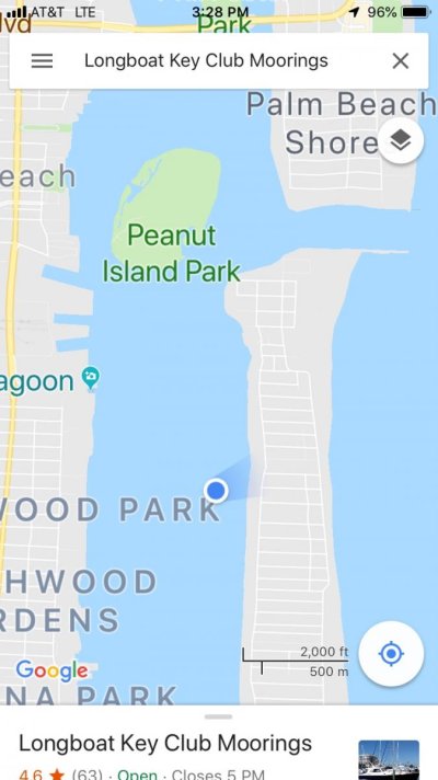
I've anchored just N of Peanut Island, rather close to Singer Island and Sailfish Marina. Looked around for decent depth as it gets shallow near Peanut, but not so deep to be in the channel.
It's a good jump off spot for WE, you will buck the current a bit, just make your course correction after crossing the highest current part of the stream, or just let it carry you to the NW part of the bank, then clear in Abaco.
It's a good jump off spot for WE, you will buck the current a bit, just make your course correction after crossing the highest current part of the stream, or just let it carry you to the NW part of the bank, then clear in Abaco.
OP
OP
cardude01
Guru
- Joined
- Nov 26, 2012
- Messages
- 5,290
- Location
- USA
- Vessel Name
- Bijou
- Vessel Make
- 2008 Island Packet PY/SP
Ok I will check out Peanut on the chart. Thanks.
I left from LW last time for West End (Memory Rock) and worked out OK to me. I guess a little more south would be better but I’m getting tired of the ICW.
I left from LW last time for West End (Memory Rock) and worked out OK to me. I guess a little more south would be better but I’m getting tired of the ICW.
menzies
Guru
Peanut is one, plus check your charts for the larger anchorage just to the south and east of the inlet. I believe it is on Active Captain and Waterway Guide as well.
We always get a slip at Sailfish Marina so that we can top up and then walk to Publix for a final provisioning, especially of fresh produce. Hopefully for one night, though we have been "caught" there once for three nights waiting for the window.
We always get a slip at Sailfish Marina so that we can top up and then walk to Publix for a final provisioning, especially of fresh produce. Hopefully for one night, though we have been "caught" there once for three nights waiting for the window.
OP
OP
cardude01
Guru
- Joined
- Nov 26, 2012
- Messages
- 5,290
- Location
- USA
- Vessel Name
- Bijou
- Vessel Make
- 2008 Island Packet PY/SP
We ended up anchoring here.

Nice and breezy. Weather looks good to cross tomorrow with S to SE winds under 10 knots, so gonna get up early and head out in the AM around 4 .
If anyone sees something bad with the weather tomorrow let me know!
This just cruised by us. [emoji15]
https://youtu.be/3hCX9wi-Ayc
Nice and breezy. Weather looks good to cross tomorrow with S to SE winds under 10 knots, so gonna get up early and head out in the AM around 4 .
If anyone sees something bad with the weather tomorrow let me know!
This just cruised by us. [emoji15]
https://youtu.be/3hCX9wi-Ayc
Attachments
Last edited:
OP
OP
cardude01
Guru
- Joined
- Nov 26, 2012
- Messages
- 5,290
- Location
- USA
- Vessel Name
- Bijou
- Vessel Make
- 2008 Island Packet PY/SP
I've anchored just N of Peanut Island, rather close to Singer Island and Sailfish Marina. Looked around for decent depth as it gets shallow near Peanut, but not so deep to be in the channel.
It's a good jump off spot for WE, you will buck the current a bit, just make your course correction after crossing the highest current part of the stream, or just let it carry you to the NW part of the bank, then clear in Abaco.
This is exactly what I did last time, and crossed around Memory Rock and anchored at Mangrove Key, but we left at night around 10pm. Wife won’t let me do that, so gonna try to leave around 4am. I think I can still make it to Mangrove before nightfall, right?
I cruise at around 6.5-7knots.
Ski in NC
Technical Guru
Should make it with plenty of daylight. I show it about 78nm as the crow flies, but with stream and weather you will take more time. Leaving 4am figure 12-14hr, gets you to Mangrove like 6pm.
Weather looks pretty good too, about 10kts SE.
Weather looks pretty good too, about 10kts SE.
menzies
Guru
Anchoring south and east of the inlet is in the ocean.
Depends which end of the inlet you are looking at.
He ended up right where AC and WG indicates.
OP
OP
cardude01
Guru
- Joined
- Nov 26, 2012
- Messages
- 5,290
- Location
- USA
- Vessel Name
- Bijou
- Vessel Make
- 2008 Island Packet PY/SP
Cool thats about what I figured. I still have my bread crumb trail from last time anchoring at Mangrove so that will help.
I can’t really remember the entrance to the bank around Memory Rock. Is it pretty easy to read the water in the afternoon? Last time I used the Explorer waypoint.
I can’t really remember the entrance to the bank around Memory Rock. Is it pretty easy to read the water in the afternoon? Last time I used the Explorer waypoint.
menzies
Guru
This is exactly what I did last time, and crossed around Memory Rock and anchored at Mangrove Key, but we left at night around 10pm. Wife won’t let me do that, so gonna try to leave around 4am. I think I can still make it to Mangrove before nightfall, right?
I cruise at around 6.5-7knots.
You should be fine for arrival in light. I had it at ~90km from Mangrove to Fort Pierce, so ~78KM sounds right from West Palm. Also running from WP to Memory Rock (Middle Shoal) has you running slightly across and with the stream rather than against it, so you will get a little help.
Check this out. Lake Worth to West End about half way down. Showing 7-9 from the SE and 1.5 to 2.5 waves from the NE for some reason, probably previous couple of days residue. Looks great
Dee Light Website
Good luck and enjoy.
menzies
Guru
Cool thats about what I figured. I still have my bread crumb trail from last time anchoring at Mangrove so that will help.
I can’t really remember the entrance to the bank around Memory Rock. Is it pretty easy to read the water in the afternoon? Last time I used the Explorer waypoint.
Do you have the Dodge Guide. Use his MEMRKS waypoint. My latest is on the boat so I don't want to give you an old one here as storms do change that shoal somewhat and he may have changed the coordinates.
diver dave
Guru
- Joined
- Jan 13, 2017
- Messages
- 2,570
- Location
- United States
- Vessel Name
- Coquina
- Vessel Make
- Lagoon 380
Depends which end of the inlet you are looking at.
He ended up right where AC and WG indicates.
This is why maybe they invented port and starboard. [emoji848]
In any case, it reminds me of lake trail, a great bike or rollerblader route. The north end of the route ends at a dock on the inlet.
menzies
Guru
This is why maybe they invented port and starboard. [emoji848]
In any case, it reminds me of lake trail, a great bike or rollerblader route. The north end of the route ends at a dock on the inlet.
Maybe the inside of an inlet should be called an outlet? :lol:
OP
OP
cardude01
Guru
- Joined
- Nov 26, 2012
- Messages
- 5,290
- Location
- USA
- Vessel Name
- Bijou
- Vessel Make
- 2008 Island Packet PY/SP
Do you have the Dodge Guide. Use his MEMRKS waypoint. My latest is on the boat so I don't want to give you an old one here as storms do change that shoal somewhat and he may have changed the coordinates.
Oh I see the Dodge waypoint is a bit different. Explorer has it at 26 55N, 79 3W where Dodge is 79 6W. So the Dodge point is better?
menzies
Guru
I use paper Explorer chart books in the Berrys, Exuma and all points south. I use Dodge in the Abacos and approaches.
The Dodge Guide gets updated annually (how much and where is hard to tell) but it hasn't let me down in 17 years.
The Dodge Guide gets updated annually (how much and where is hard to tell) but it hasn't let me down in 17 years.
OP
OP
cardude01
Guru
- Joined
- Nov 26, 2012
- Messages
- 5,290
- Location
- USA
- Vessel Name
- Bijou
- Vessel Make
- 2008 Island Packet PY/SP
So my wife is asking why aren’t we going to the marina on west end to check in and relax. I told her because I would have to crab against the current to get there, or let the current take me north and come back. Am I being hard headed?
diver dave
Guru
- Joined
- Jan 13, 2017
- Messages
- 2,570
- Location
- United States
- Vessel Name
- Coquina
- Vessel Make
- Lagoon 380
Yes, quite hardheaded. As punishment, have her fly ahead to Atlantis with 10 large pocket money, whiled u catch up midweek. [emoji23]
OP
OP
cardude01
Guru
- Joined
- Nov 26, 2012
- Messages
- 5,290
- Location
- USA
- Vessel Name
- Bijou
- Vessel Make
- 2008 Island Packet PY/SP
Yes, quite hardheaded. As punishment, have her fly ahead to Atlantis with 10 large pocket money, whiled u catch up midweek. [emoji23]
How is the entrance to that Old Bahama Bay Place? Is it pretty easy? Is it hard to get a slip if I just show up?
How would I get there from Lake Worth? Go straight across and let the current take me up and then come back down? Or head south for a bit before the Gulf Stream?
diver dave
Guru
- Joined
- Jan 13, 2017
- Messages
- 2,570
- Location
- United States
- Vessel Name
- Coquina
- Vessel Make
- Lagoon 380
Very easy approach to OBB. Sorry, just have phone right now. What is cruising speed and ultimate destination?
diver dave
Guru
- Joined
- Jan 13, 2017
- Messages
- 2,570
- Location
- United States
- Vessel Name
- Coquina
- Vessel Make
- Lagoon 380
U will have a significant crab angle for 3/4 of the trip. Doable, but it will keep u out in the blue 6 hours or so extra. Windy forecast looks really good for the week. Too bad walkers is shut down. Give it a shot and if ETA looks too long, then come up to cross bank at Indian or memory. Draft?
RT Firefly
Enigma
Greetings,
Mr. cd. "Am I being hard headed?" ABSOLUTELY!!!!! If Mama's happy, everyone is happy.
Chill mon. West End is closer. Leave in the morning at a decent time, wander your way over, check in, hit the bar, swim. Are you in some sort of race?

Mr. cd. "Am I being hard headed?" ABSOLUTELY!!!!! If Mama's happy, everyone is happy.
Chill mon. West End is closer. Leave in the morning at a decent time, wander your way over, check in, hit the bar, swim. Are you in some sort of race?
diver dave
Guru
- Joined
- Jan 13, 2017
- Messages
- 2,570
- Location
- United States
- Vessel Name
- Coquina
- Vessel Make
- Lagoon 380
Great. The little bahama bank is your oyster.
menzies
Guru
So my wife is asking why aren’t we going to the marina on west end to check in and relax. I told her because I would have to crab against the current to get there, or let the current take me north and come back. Am I being hard headed?
Leaving WP for the Bahamas we have always overnighted at WE if going to Abaco, or Lucaya if going south.
Just a nice stop to reset after the gulf crossing. But then we are normally going for three months. If you have a shorter timeframe, then by all means go ahead through the shoal to Mangrove.
Then again, if the wife ain't happy - ain't nobody happy!
menzies
Guru
My Dodge guide is from 2011. Do you have a more updated MEMRKS?
I'll go down to the boat and get it and let you know in a few.
Similar threads
- Replies
- 7
- Views
- 618
- Replies
- 20
- Views
- 2K