Alaskan Sea-Duction
Guru
- Joined
- Jul 6, 2012
- Messages
- 8,058
- Location
- USA
- Vessel Name
- Alaskan Sea-Duction
- Vessel Make
- 1988 M/Y Camargue YachtFisher
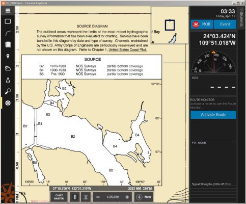
For those cruising north to Alaska. This place is northwest of Petersburg.
Uncharted shoaling was observed in Francis Anchorage on February 14th, 2019 in position 57°08.95’N, 133°10.03’W. The charted depth for
this location is 15 fathoms and the observed depths rapidly shallowed from 120 feet and ranged from 8 to 10 feet. The navigational charts for
Francis Anchorage are based on pre-1900 Partial Bottom Coverage Surveys and in 1976 ‘shoaling to bare’ was reported further into the
anchorage. Mariners should transit this area with extreme caution and be aware of areas that may not be adequately charted.
Questions/concerns should be directed to Todd Buck with the Coast Guard District 17 Waterways Management Office at (907) 463-2269 or by
email to todd.r.buck@uscg.mil.