Side-scan?

The friendliest place on the web for anyone who enjoys boating.
If you have answers, please help by responding to the unanswered posts.

wkearney99

Guru
Joined
Feb 17, 2018
Messages
2,164
Location
USA
Vessel Name
Solstice
Vessel Make
Grand Banks 47 Eastbay FB
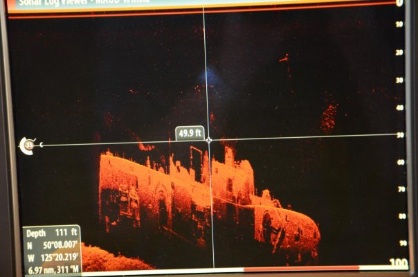
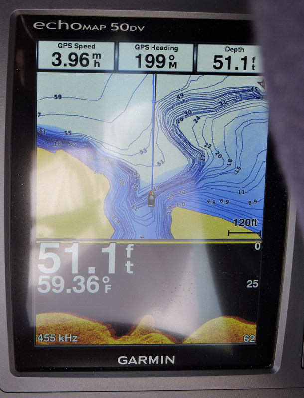
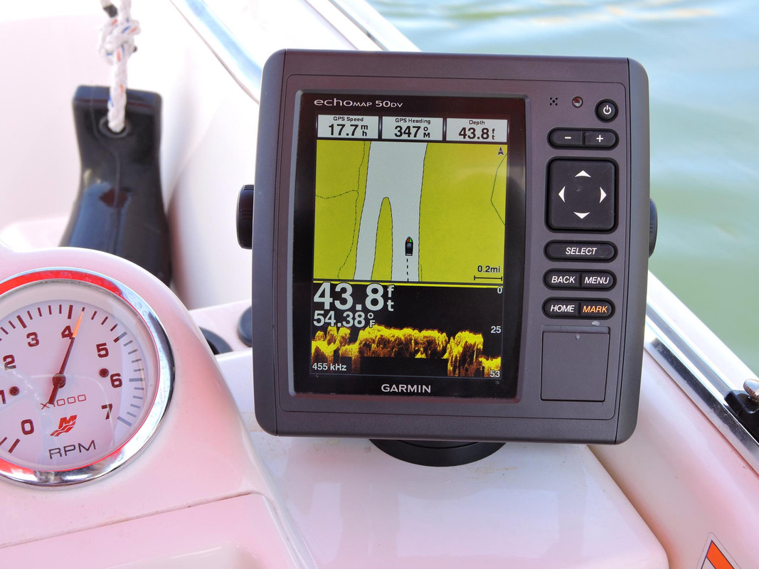
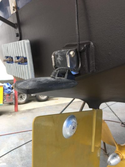
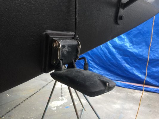
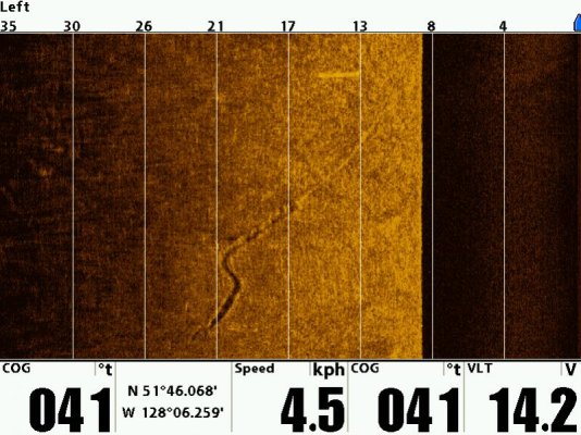
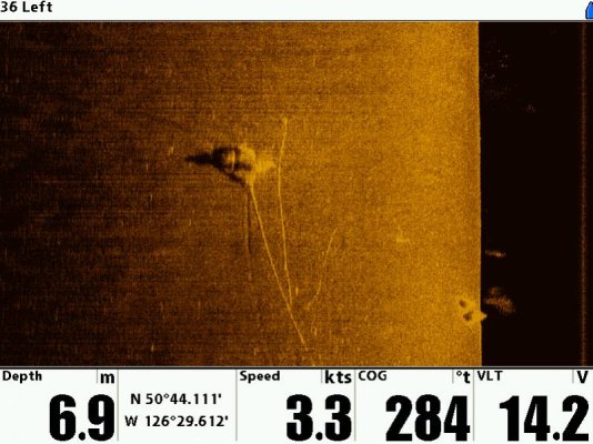
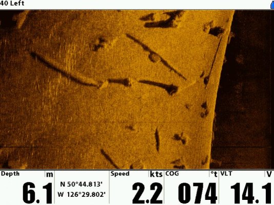
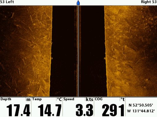
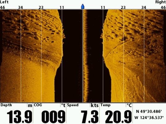
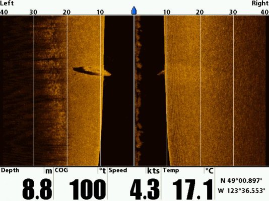
Anyone played around with any of the sidescan sonar systems?

I've always been interested in them, if not for actual fishing, just for curiosity about the sea floor I'm traveling over. Stuff like Simrad G07XSR with the TotalScan transducer comes in at a pretty inexpensive entry point. It'd be interesting to make use of one of those. Not necessarily as a primary chartplotter, but as an added network display for data, along with the sonar imagery.

If I'm going to move things around but not commit to a total replacement of all four 12" chart plotters something like this could be a fun interim taste of more recent features.

Anyone had one of these onboard and care to comment about the experience?
 
we had one of these on a previous boat https://www.wesmar.com/commercial-fishing-hull-mounted-sonar It was pre chirp and multiple element transducers. The transducer dome was on a elevator and the transducer was motorized so it would side scan up to the surface , look forward, or just down. I never used the side scan function but looking forward when ever we went into unfamiliar anchorages was invaluable... The image was very noisy at any speed above about 7 knots.

The issue with current side scan is mounting the transducer. a keel will block the side signal on one side... The pictures sure look nice though.
 
We have a Simrad Structurescan on Blue Sky, installed in 2014. I find that I never use the sidescan but the straight down is amazing down to about 300 feet or so. Great detail, and I use it to show wrecks and sometimes a detailed look at the bottom. But to be clear, it is only for entertainment. A proper Furuno FCV-588 covers the depth reliably down to about 1000 feet plus shows the fish of course.
Perhaps I just never gave the sidescan a chance, but I found that it was more confusing than helpful.

Attached is a photo of the Structurescan looking at the HMCS Columbia sitting on the bottom near Seymour Narrows.
 

Attachments

  • DSC_0348.jpg
    DSC_0348.jpg
    94.7 KB · Views: 97
We've found there are two levels of forward or side scanners. One is the basics that Garmin, Raymarine and Simrad now include with their systems. Their usefulness is really limited to slow speeds and fairly short distances but for that they're extremely helpful. We had the Garmin on a boat and used it several times when we were concerned about the bottom and contour and it always was useful.

Then there are units like Farsounder and Echopilot, both of whom offer multiple levels. These greatly extend distances and details. Still primarily for slower speeds and fairly short distances but much more range than the basic units.

I strongly recommend some form of sonar scanner as on the occasions you do need one, it's worth every penny you spent on it. Thankfully, most full electronics packages now include the functionality.
 
Last edited:
Part of my interest here is looking for additional ways to show data on the helm, and to address jobs that are best done while already out of the water. I can add a display anytime. Adding a sonar sensor, that's best done while already out of the water, which is where we are at the moment.

Adding a forward sensor seems like an invitation for complications. Ours is a planing hull and past experience with depth/speed/temp sensors tells me I'd be in for a bit of an adventure finding "the best" location for a faired sensor. But something like a transom-mounted sidescan unit might be less complicated, or at least allow for some arms-reach adjusting without totally hauling out.

I have to double-check that the lowering swim platform won't interfere with what locations might be best for mounting it. That'd put me back into needing a faired location under the hull.
 
Side scan is best left to fishermen and divers looking for structure. I have had a Humminbird unit for 8 years. I have not found any benefit that would help on my trawler. But if you insist, you may have issues mounting the transducer. 99 percent of them out there are transom mount types designed for outboard boats of shallow deadrise. The TD needs clear, submerged view to either side of the mount (no keel, rudder, trim tabs, or air gap when on plane. If you mount it dead center of the transom with a keel, there will be a lot of turbulence noise from the prop and rudder. At speeds above about 6 knots, there is just too much turbulence to show any detail. You only see what you passed because they are mounted on the transom.

There is at least one manufacturer that offers 2 separate thru-hull TD's for inboards with keels. Can't remember which one but they were PLASTIC!!! Not even Marlon.
 
The TD needs clear, submerged view to either side of the mount (no keel, rudder, trim tabs, or air gap when on plane. If you mount it dead center of the transom with a keel, there will be a lot of turbulence noise from the prop and rudder. At speeds above about 6 knots, there is just too much turbulence to show any detail.

Well, given this is an Eastbay with twin engines and a planing hull, I've got a little more flexibility regarding placement. I'm guessing a block set up above the center 'keel anodes' and a bracket might give me some mounting flexibility. No rudders or props directly in front of it in that location.

I understand that a transom mount is providing an 'already passed' field of view. Some of the newest plotters have enough memory to keep a fair bit of obtained data, allowing for some pretty nifty ways to replay/rotate/zoom through scanned data. Granted, adding those features bumps you up to the next tier of display and pricing, of course.

This is still at the "I wonder what my options are?" stage.

I don't need it but if it doesn't bump the price a lot it might be worth the entertainment value.

But to get to the 3D pan/zoom/rotate level of functionality it's easily $1k more. That's enough to make me second guess my willingness to defend the idea with a straight face to the wife.
 

Attachments

  • 20181213_115834.jpg
    20181213_115834.jpg
    142.2 KB · Views: 80
Well, given this is an Eastbay with twin engines and a planing hull, I've got a little more flexibility regarding placement. I'm guessing a block set up above the center 'keel anodes' and a bracket might give me some mounting flexibility. No rudders or props directly in front of it in that location.

I understand that a transom mount is providing an 'already passed' field of view. Some of the newest plotters have enough memory to keep a fair bit of obtained data, allowing for some pretty nifty ways to replay/rotate/zoom through scanned data. Granted, adding those features bumps you up to the next tier of display and pricing, of course.

This is still at the "I wonder what my options are?" stage.

I don't need it but if it doesn't bump the price a lot it might be worth the entertainment value.

But to get to the 3D pan/zoom/rotate level of functionality it's easily $1k more. That's enough to make me second guess my willingness to defend the idea with a straight face to the wife.


For it to work at anything above dead idle, the TD will have to be mounted below those zincs. The prop pockets are out. The outside edges are out. The trim tabs are obviously out. That leaves only the center 12" or so to place it and it needs to be parallel to the water surface.
Before you buy, check the manufacturers TD installation instructions and TD dimensions.
 
Here's a photo of our Garmin 50DV. It's easy to see the bottom contour in this shot, taken at ~4mph. The faster you go the less detail you're going to see, but I've found when it starts to get shallow I'm not going very fast.
DSCN2006.jpg

Here's another shot, not quite as deep but at ~18mph. Still excellent bottom detail.

a-DSCN2868.jpg
 
For it to work at anything above dead idle, the TD will have to be mounted below those zincs. The prop pockets are out. The outside edges are out. The trim tabs are obviously out. That leaves only the center 12" or so to place it and it needs to be parallel to the water surface.
Before you buy, check the manufacturers TD installation instructions and TD dimensions.

Agreed. My thinking is leave the zincs where they are and add a mounting block above them. Hang the transducer from there, with what will undoubtedly be a custom-made bracket, presumably one with some adjustability designed into it.
 
Perhaps I just never gave the sidescan a chance, but I found that it was more confusing than helpful.

Attached is a photo of the Structurescan looking at the HMCS Columbia sitting on the bottom near Seymour Narrows.

I have had SS for a couple years. Great if you are a shallow water bass fisherman, or, for deep stuff, you have to tow a fish. In deeper water, the angles don't work out well unless the sensor is deep also.

That is a very nice wreck shot!!
 
Side Scan

I have used side-scan professionally and have had a Humminbird on our KK42 for the past 5 years. I use it all the time in anchorages to see what is on the bottom prior to anchoring. In the PNW, many anchorages are covered with sunken logs and cables from the logging industry. Cables show up really well. Logs, wrecks and other debris (stumps) show up. Also bedrock and cobble bottoms show up.

I bought an extra transducer (about the size of a hand) for the skiff and can move the head unit back forth between the KK and skiff. Nice for looking at you anchor set. I found my stern anchor once with the SS because it had a floating line and clearly showed up in the sonar image.

These units have limited power so work best in 60' or less.

I would welcome suggestions for keeping the mussels off. Will try to find a few pictures.
 
Well, given this is an Eastbay with twin engines and a planing hull, I've got a little more flexibility regarding placement. I'm guessing a block set up above the center 'keel anodes' and a bracket might give me some mounting flexibility. No rudders or props directly in front of it in that location.

I understand that a transom mount is providing an 'already passed' field of view. Some of the newest plotters have enough memory to keep a fair bit of obtained data, allowing for some pretty nifty ways to replay/rotate/zoom through scanned data. Granted, adding those features bumps you up to the next tier of display and pricing, of course.

This is still at the "I wonder what my options are?" stage.

I don't need it but if it doesn't bump the price a lot it might be worth the entertainment value.

But to get to the 3D pan/zoom/rotate level of functionality it's easily $1k more. That's enough to make me second guess my willingness to defend the idea with a straight face to the wife.
Bill, I took another look at your picture. Why not mount the transducer at the bottom of the transom just outboard of where your trim tabs are mounted?

In the photos of my Garmin display, those are from two different Whalers. They're both mounted directly to the transoms, with the transducer in the water. The transducers stay in the water and give a good reading even at planing speeds as you can see in my second picture.
 
Here's the mounting of my Humminbird SS transducer on the KK42 transom.
 

Attachments

  • HaulOut_2018_068.bJPG.jpg
    HaulOut_2018_068.bJPG.jpg
    68.6 KB · Views: 44
  • HaulOut_2018_071b.jpg
    HaulOut_2018_071b.jpg
    82 KB · Views: 47
I'm headed down to the boat today. On my list is checking how closely the hydraulic platform tracks to the hull when raising/lowering. Might be a moot point if the platform would whack it.

There have also been situations where lines get pulled across the transom, so I'd want to avoid getting caught and knocking a sensor out of alignment. We've got various floats and other toys that get used while out for the day swimming while anchored. Sometimes the lines tethering them to the boat will get fouled at the platform. Not always, but I've learned to plan for the 'worst case' when it comes to setting up gear.
 
I finally got to the boat and got my chip w side scan images. When I am imaging from the skiff, I can only image to the left/port side because the motor is in the way to the right/starboard. When in the KK I can image to both sides. This system is of great assistance in choosing an anchorage.

1. SS image of anchor drag from skiff. the furrow is 8m long before it "set".
2. I think this is a logging winch with cable. Note how well the cable shows up.
3. Logs and stumps on the seabed - you better not anchor here!
4. Imaging from the KK42 showing seabed to each side. Seabed covered with logs!
5. Sedimentary bedrock (top half of image and sand bottom (lower left).
6. A wreck on the seabed - this one about 30' long - a popular anchorage.
 

Attachments

  • SS_1.jpg
    SS_1.jpg
    94.6 KB · Views: 42
  • SS_2.jpg
    SS_2.jpg
    81.2 KB · Views: 38
  • SS_3.jpg
    SS_3.jpg
    95.2 KB · Views: 42
  • SS_4.jpg
    SS_4.jpg
    80.8 KB · Views: 35
  • SS_5.jpg
    SS_5.jpg
    95.5 KB · Views: 43
  • SS_6.jpg
    SS_6.jpg
    78.8 KB · Views: 38
I checked yesterday and the platform doesn't descend far enough to be any sort an issue.

I would welcome suggestions for keeping the mussels off.

When I discussed this idea yesterday my boat guy said "and keeping barnacles off those sensors is a hassle." Meaning the L-shaped ones intended for transom mounting.

He's not a fan of that kind of installation, much preferring the through-hull sort. The trick being finding the ideal location, of course. That and we've been getting enough debris in the Chesapeake lately to make anything other than a pretty sturdy mount raise potential for problems.

I think this will fall into the 'thought experiment' category for now.

Mainly because if I'm going to do this, I might as well do it as part of a larger chart plotter upgrade plan. There's no sense in attempting to integrate it with the existing Navnet3D displays, as they're obsolete. Nor, really, is there much point in doing an 'entry level' install as little of that would remain viable when we get to a plotter replacement.
 
When I discussed this idea yesterday my boat guy said "and keeping barnacles off those sensors is a hassle." Meaning the L-shaped ones intended for transom mounting.

He's not a fan of that kind of installation, much preferring the through-hull sort. The trick being finding the ideal location, of course. That and we've been getting enough debris in the Chesapeake lately to make anything other than a pretty sturdy mount raise potential for problems.

I don't think there are thru-hull versions of the side-scan transducers but I may be wrong.

The bracket I have is the hinged, tip-up type. So far, never tipped in 3 years of operation and we have plenty of debris in the water. My current mussel/barnacle control is getting in with a wet suit and snorkel every 6 months and scraping/brushing the transducer.

I use the Humminbird (plotter/sounder/side-scan) as a stand-alone, backup system. It is independent of my primary navigation (still running off a desktop - LOL - waiting for that to fail before upgrading).
 
Raymarine makes a thru hull sidescan transducer. Two will give you right and left.

Tom
 
Side Scan

We installed a Garmin 7612xsv last year with Chirp and a through hull transducer on our Chris. Love the chart plotter, but haven’t quite figured out the side scan application. Thinking it will be helpful for Great Lakes cruising.
 
Back
Top Bottom