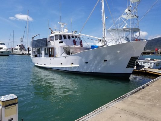
Great Barrier Reef cruise

The friendliest place on the web for anyone who enjoys boating.
If you have answers, please help by responding to the unanswered posts.
I'm sure you will enjoy Upolu. I went past it on my way into YKBC marina, and there was a tour boat on the NE side. I think Sep is one of the best months to make a visit.
Where else are you going?

Although there has been cyclones and bleaching events during the last 4 years the reef is quite resilient. I have been pleasantly surprised by the amount of healthy coral in the northern reef area, which was supposedly devastated and wiped out. For sure, there has been a lot of damage, and recovery is on-going and will take some time. But IMO visitors still get a great experience!

Thanks Brian,
Just catching my breath a bit. Left LA evening of Thursday crossing 19 time zones, the equator, and international date line to arrive Cairns this Saturday AM without a single sunrise! Strange.
We will base here touring south as far as South Mission, north to Palm Cove and Port Douglas. Mostly diving with some day trips and one live aboard hoping to get in at least ten dives and then see some upland highlights as well.
Recommendations welcome as we are flexible!
 
Not to stomp on Brian's thread but on my first stop here (walking the docks at Cairns), a delightful welcome provided by the visage of Torsk. She the Malahide that last I heard was for sale lying somewhere in the Adriatic.
 

Attachments

  • 20180914_202420.jpg
    20180914_202420.jpg
    148.4 KB · Views: 64
All posts are welcome, no problems! Cairns is a good base this time of the year. There are quite a few different dive/reef businesses, which should mean they are competitively priced and offer good day trips! I hope the ones you take give you a great experience. I have encountered a few of the larger vessels that do multiday tours, and they look to be well organised.

Its been a long time since I visited the Atherton Tableland, but I think you can easily do a loop drive through several of the small towns, and visit some art galleries etc particularly at Yungaburra. And the obvious day trip is to do is the Kuranda markets, railway one way and then cable car the other way. The aquarium is highly regarded. also.
 
Decent looking tinnie on the front of Torsk as well.
 
All posts are welcome, no problems!... And the obvious day trip is to do is the Kuranda markets, railway one way and then cable car the other way...
We did that trip. Returning,the cable car was getting side on bullet gusts flicking it sideways and up. Doubtless perfectly safe (think Dreamworld) but we enjoyed the train up ride more.
 
Decent looking tinnie on the front of Torsk as well.


The tinnie is stout for sure.
And, of course this is a Romsdal and not a Malahide, though both are fine vessels. This one not as impeccable as Delfin for sure, but still inspiring.
Palm Cove today. Quite nice. Looking forward to our first trip out to the reef tomorrow.
 
Brian
Two questions
Is it difficult to avoid anchoring in coral areas?
How is battery system holding up with no genset?
Thanks
 
Away from the reefs the water depths are anything from 30m to over 60m. But as you near the reefs it often shallows to 10-15m (sometimes 20-25m), and with high sun angles and preferably low tides you can see enough of the bottom to distinguish coral from sand, provided it is not more than about 15m deep. So I go in reasonably close, but allow swing room for wind shifts, and usually manage to anchor on sand. You need to watch out for isolated coral heads, but once again high sun angles work well for that.

Last night I was in 8m of water as there was a clear approach to the reef, and lots of sandy bottom to chose from. The vertical wall of the coral reef was about 75m away. The charts often have 'foul area' marked on them, which basically means irregular depths to coral bottom with no sand. I don't try an anchor in those areas, and am quite wary when traversing them as well.

As you know I have 2000 W of solar panels. In Jun-Jul, and down south, I had to use the Honda fairly frequently. But Up north in Aug the panels could keep up. Now in Sep the panels manage easily. Having said that, I often move 20-30nm each day to a new reef area, so get engine charging as well.
 
Last edited:
We just completed three days diving from a steel motor sailor on Hasting Reef,
Michaelmas Reef, and Upolu Reef.
Wonderful adventure and I am completely envious of your great cruising area.

I can surely understand the need for a very capable vessel to ply these waters as protection is pretty scarce when you are out there.

The skipper used a very interesting and useful way of the overnight mooring using a bridle from bow to stern that put the vessel mostly broadside to the wind/wind waves (SE) but directly bow into the swell (N). Sleeping was quite comfortable at what seemed to be 10-20 knots overnight and day.

Half of the guests (small boat) at the rail for the trip out, but seemed to settle in once in the lee of the reef.

Highly recommend a trip like this and wishing we were here longer for sure. Flora and fauna on the reef is spectacular and water temps are perfect!
 
Bill, you’re not getting any younger. Move one of your boats down there and commute.
Thanks for the updates Brian
 
The skipper used a very interesting and useful way of the overnight mooring using a bridle from bow to stern that put the vessel mostly broadside to the wind/wind waves (SE) but directly bow into the swell (N). Sleeping was quite comfortable at what seemed to be 10-20 knots overnight and day.

Klee...could you expand on this please? Maybe a sketch or...?

thanks
 
Klee...could you expand on this please? Maybe a sketch or...?

thanks

Attached please find my attempt at a sketch of the reef mooring. We were 50 meters from the reef wall and this mooring depends mostly upon the wind remaining constant in direction which it did. The secondary would have kept him off the reef wall in any case. I thought this was a really neat way of making the boat quite comfortable to be on. Hopefully the sketch shows that by adjusting the branch of the bridle from the stern, he positioned the boat so that the wind was from just slightly aft of full beam. She sat beautifully steady with nothing more than the two masts and this mooring to stabilize her.
 

Attachments

  • Reef Mooring.jpg
    Reef Mooring.jpg
    67.9 KB · Views: 50
Last edited:
Klee
That mooring setup looks good, and simple to adjust. Given he is a commercial operator I am guessing he has private moorings in place to do it. A lot of them do this at the places they take regular visits to. They like to be close to dive/snorkel spots so that they don't need to ferry people in RIB's.

Unless there are public mooring available I tend to anchor away from the coral walls in more shallow water and then launch the RIB to get to a better location to jump into the water.
 
To add to what I was describing in post #128, here are some pics. First is a screenshot of the plotter. As I approached Keeper Reef I passed through an area of '<10m' on the chart. The pale blue area. Water depths were 19m mostly, but there was isolated areas of coral within 10 of the surface.

As I got to the green area (an envelope bounding shallow coral) I saw shallow coral, as you see in pic 2 in foreground, which is pale green. The shallow area near the continuous reef is pale blue. The colours are far more clear with polarising sunglasses. Unfortunately I don't have a polarising filter for the camera!

I could see a gap of 100-150m between the isolated heads of shallow coral so travelled NW before entering the gap, and moved well into the green area on the chart. In pic 3 you can just discern some darker areas in the foreground. These are patches of coral that rise a couple of metres above the sandy bottom. IIRC the water was about 10m deep here. I went in closer to the pale blue area and anchored in sand in 8m of water.

The next day, despite leaving early when I could not see the areas of coral I went straight back out along my entry path, and after initially avoiding a guy trolling on my planned route I joined it and then continued SW to the next reef and repeated the process!
 

Attachments

  • Keeper Reef screenshot.jpg
    Keeper Reef screenshot.jpg
    70.9 KB · Views: 37
  • Keeper Rf 1 sml.jpg
    Keeper Rf 1 sml.jpg
    108 KB · Views: 39
  • Keeper Rf 2 sml.jpg
    Keeper Rf 2 sml.jpg
    122.8 KB · Views: 35
Last edited:
Moving further SW I went out to an area not all that well charted. We are all familiar with chart plotters showing more detail as you zoom in. Shallow areas appearing etc. What I found at Wallaby Reef and areas nearby was kinda the opposite: areas of reef disappeared as I zoomed in!

Pic 1 shows the area I am referring to. The grey coloured area indicate not well charted, or even uncharted. My track is crossing reef (green area) in quite a few places. But as pic 2 indicates, when zooming in I was actually in reasonable depths of water. Mostly. There were more places with coral with only 4-6 m of water, shown as >10m depth, than I liked! I would not traverse these grey areas of the charts unless I had high sun angles.

When going south in the channel between Gould and Cobham Reefs I had a 2kn adverse current. So I went to the East side to see if I could reduce the current. No luck, strong current right up against Cobham Reef. I then went over to the west, to Gould Reef, and found I could get a 1kn reduction in current close to the reef. I stayed about a boat length off the reef, and was travelling at 7kn. Pic 3 is while I was doing this, and shows reef with about 1m of water. Yet I had over 30m depth a boat length off the coral wall. Overall the channel was 8 cables wide, and most of that was 65m deep.
 

Attachments

  • Gould reef screenshot sml.jpg
    Gould reef screenshot sml.jpg
    133.5 KB · Views: 32
  • Gould Rf Zoom screenshot.jpg
    Gould Rf Zoom screenshot.jpg
    113.4 KB · Views: 30
  • Gould Reef 1.jpg
    Gould Reef 1.jpg
    116.1 KB · Views: 30
Last edited:
When in the Wallaby Reef and Gould Reef areas there were a couple of Cays not shown on the chart. The one at the N end of Wallaby Reef was just covered at high tide. Pic 1 shows it on my approach.

I had thought it was a sand cay, but it turned out to be made up of broken coral pieces, as in pic 2. I anchored the RIB in 2m of water (sand patch), and then snorkelled about 100m to the Cay. The boat is further out, in 10m of water. Pic 3 shows this, unfortunately in wide angle format!
 

Attachments

  • N Wallaby cay 1 sml.jpg
    N Wallaby cay 1 sml.jpg
    108.6 KB · Views: 29
  • N Wallaby cay 2.jpg
    N Wallaby cay 2.jpg
    210.8 KB · Views: 32
  • N Wallaby Cay 3 sml.jpg
    N Wallaby Cay 3 sml.jpg
    162.5 KB · Views: 42
I have noticed some changes in the areas around the reefs, from about 18°45'S latitude. Moving to the south it is less common to find sandy areas outside the main reef, and often water is 18m or more (with coral bottom) right up against the coral walls. In these areas I've needed to go inside the reef boundaries, usually possible in the larger reef complexes, to find partly sandy bottoms with <18m depths. The NW sides of linear reefs often will have shallow areas as well. Small reefs can have deep water all round them.

The second change is the tidal current. In the northern reef, particularly N of Cairns, along the Ribbon Reefs etc, the only places with significant current were gaps in the reef to open ocean. And even then, current was not very strong. But moving south, it is common to find 2kn of tidal current. This can make selecting anchorages more tricky as I prefer to not have a reef gap with a current at too great an angle to the wind.

It also means that I need to restrict snorkelling to the times of slack tides. I can't swim fast enough to counter those currents, and am even a little concerned that the single engined RIB might be problematic as I could not paddle it against the current either. So areas I take the RIB, and then snorkel, are always going to be up-current by the time I'm ready to return to the boat.
 
Final catch-up post. One of the issues with travelling SE along the outer reef rather than the coast is lack of phone (internet) and often sat TV as well. A lot of the time it is still possible to get weather forecasts on VHF from the Volunteer Coastguard/VMR bases along the coast. The problem with those, however; is that between Townsville and Mackay (and north of Townsville too for that matter) many of these stations operate on weekends only.

And so it was that I had a rough trip into Stonehaven Bay this morning. I had been meandering down the outer reef for 6 days, and often could not get weather forecasts. Mostly light winds, and the last couple of days winds of 5kn or less, and this is when the reef is magic.

The last forecast I had was for the SE change that was due to arrive midday Friday to actually be a little earlier. Winds 15-20 just before dawn. So I laid a route to follow, had an early night and raised anchor at first light. As it turned out I ought to have left an hour earlier. Less than halfway into a 4 hour trip it was 20-25kn and then increasing to around 30kn. Gusts to 40kn. Seas built fairly quickly. For a lot of the time I had 1.5-2m seas on my port quarter, and the boat rode quite well although the stabilisers could not take all the roll out. But for about 8nm seas were over 2m, winds into 30kn range and it was unpleasant, although not unsafe. It isn't going to get below 15kn for a week so I'll have to hang around the Whitsunday's for a time. I wan't to get bck out to the outer reef and continue SE, but only if winds are not forecast above 15kn. They are often a bit more than forecast out on the reef anyway.

I'll probably spend a day or two in Cid Harbour, but I never snorkel or swim there. It has some mangrove shorelines. An unfortunate recent reminder to stick with that policy!

https://www.9news.com.au/2018/09/20/14/12/second-shark-attack-queensland-cid-harbour
 
Last edited:
Hi Brian,

Glad to hear you are well! Like others, I have been watching your adventures with interest.

If you are in Cid Harbour / Sawmill Bay on Sunday, the annual Australian GB rendezvous will be held there at that time. Usually lots of GBs and Palm Beach in attendance, the QLD dealer Todd H hosts the event (he is a good guy).

I wont be there unfortunately, but if you happen to catch up with any of them pls say hello from me.

Hamish.
 
...I'll probably spend a day or two in Cid Harbour, but I never snorkel or swim there. It has some mangrove shorelines. An unfortunate recent reminder to stick with that policy!

https://www.9news.com.au/2018/09/20/14/12/second-shark-attack-queensland-cid-harbour
Knowing your snorkelling exploits I wondered were you near Cid Harbour, it seems you are or will be.
2 shark attacks in 24 hours in one area is a worry, fortunately both look like ending as well as they can, largely due to excellent first aid. As a southerner, are mangrove shorelines known elevated risk areas?
 
I don't know if any particular species of shark prefer those areas or not. Perhaps bull sharks? Mangroves provide good fish breeding areas, and where there are food sources...... Water is not as clear there, and I do prefer very clear water for swimming etc.

But my main aversion to mangrove areas for swimming is estuarine crocodiles. They are apex predators, and although sightings are rare they have been seen around the islands occasionally. Anywhere north of Gladstone is croc country. When up at Lizard Island I was told there had been a slide on the beach not all that long ago, estimated to have been made by a croc of around 2.5m. They are territorial. Their range will continue to increase as their population expands, although open ocean and islands well off the coast should not have a significant issue with them for some time yet.

I'll likely go to Cid Harbour on Monday for a couple of days if the weather is clear as I ought to climb all the way to the peak. It can get crowded, and Sunday's GB rendezvous might accentuate that. Hamish, if you were there I'd join in, interloper or not!
 
Finally there is a break in the weather! I've been chilling in the Whitsunday area for 10 days while the winds have been over 15 kn and often over 20kn. Of course its a great place to spend some time, so no real hardship! I went ashore at Dugong Beach to climb to Whitsunday Peak, elevation 434m. That beach landing adds another 1km each way, and helped ensure that I was pretty stiff and sore afterwards. Knees in particular (sports injuries to both in the past), but also feet. Pics of Hamilton Island (resort hotel centre of pic, just below horizon), and then Cid Harbour looking towards Hook Island. Insequent is in the middle of second pic, closest of the boats to shore.

I also enjoyed Whitehaven Beach for a couple of days, and one of the 14 mooring buoy 's at Tongue Inlet. Both very popular spots this time of year, but large areas so not particularly crowded.

Tomorrow is the start of a week of forecast wind below 15kn, and quite a few days of below 10 kn. So first stop will be Square Reef. Then I'll meander south along the reef, and likely come back into the coast (and internet) around Port Clinton.
 

Attachments

  • Whit Peak 1 sml.jpg
    Whit Peak 1 sml.jpg
    151.7 KB · Views: 86
  • Whit Peak 2 sml.jpg
    Whit Peak 2 sml.jpg
    87 KB · Views: 80
Last edited:
Brian...another great post, thanks. I am taking careful notes of your passage, as I hope to largely replicate it next year. More often than not, I have to google to find the reefs you are referencing and visiting. What pilots or guidebooks are you using to get info on places to visit?
 
Paul
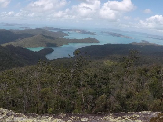
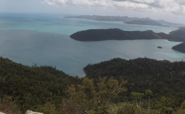
I just got back into internet range this afternoon. After going out to Square Reef (due east of Whitsunday Island) I made the most of the forecast of 5 days of 10-15kn northerlies. In general you want to gain as much southing as you can when the northerlies are present, as bashing into the normal SE winds gets old pretty quickly.

The only issues I had were no phone service and also only intermittent sat TV. My 45 cm KVH really does not work north of Cairns or out on the reef much south of Cairns as the reef starts to become further offshore. If you want TV out there you need a 60cm dish.

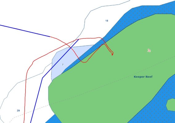
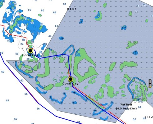
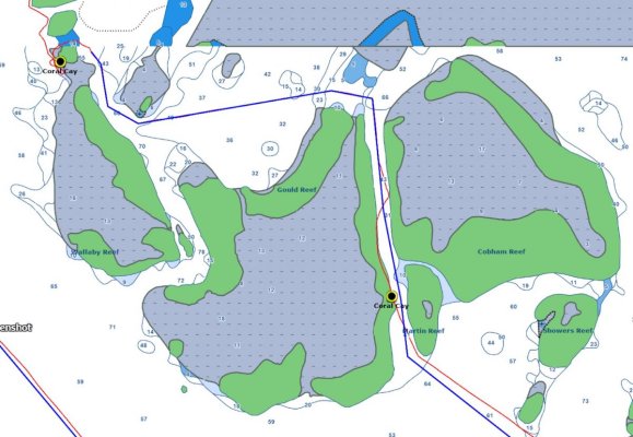
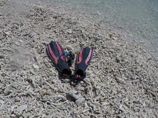
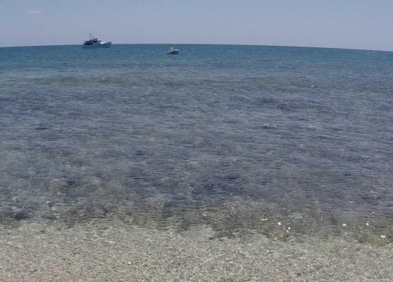
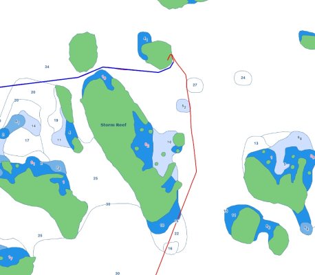
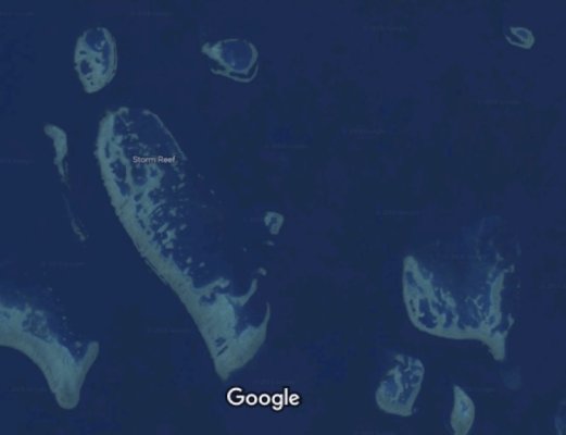
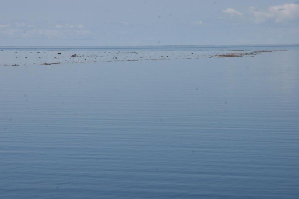
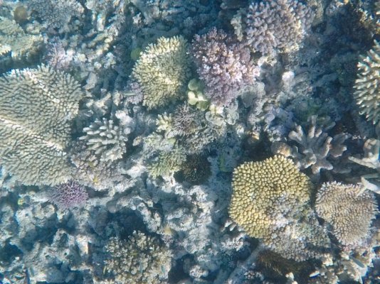
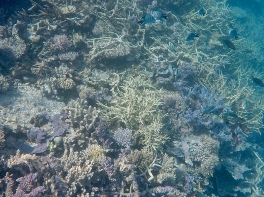
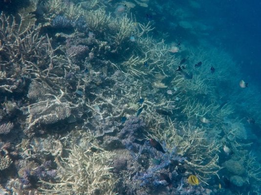
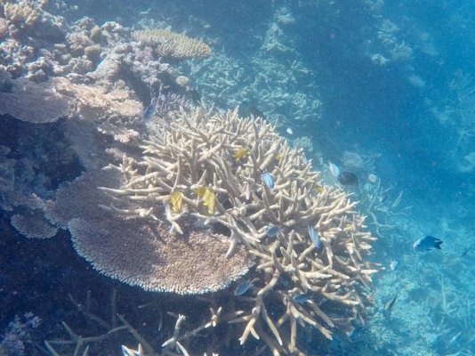
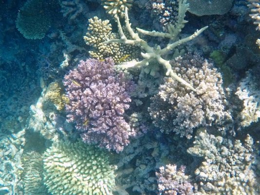
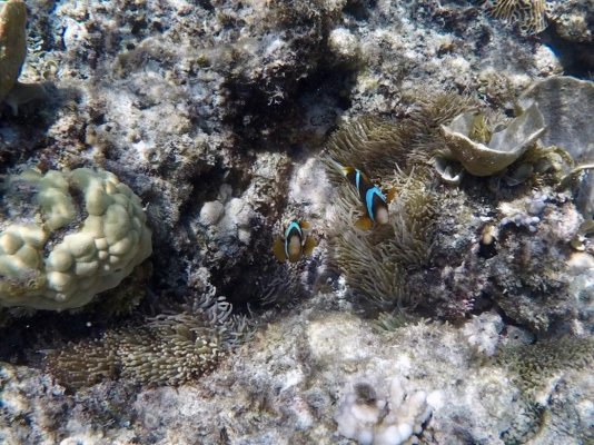
Overnights were at Little Stevens Reef, south of Pompey Reef, NE of Storm Reef and finally at Heralds Prong No 2 Reef. Stops along the way for snorkelling.

This section of the Barrier Reef tends to have reef walls on south and west sides (and often on other sides too!), with deep water (well, 30m or so) adjacent. So with northerlies I had to hunt for a bit of protection. For this the satellite images on Google maps (save map for offline use when you have a connection) works very well. The charting is reliable enough, I found, but lacks detail in the southern Barrier Reef area in particular.

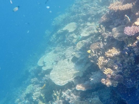
As to Guides, Alan Lucas' Cruising the Coral Coast is quite good, but it does not cover much of the reef. He was focussed on the coast, and gunkholing the rivers etc. I cruised many of those areas a couple of years ago, but this time I avoided shallow & murky water as much as possible as I wanted to swim/snorkel. The only other guide I used was the '100 Magic Miles', aka the charter boat bible for the Whitsundays. It is very good. But it does not have much on the reef either.

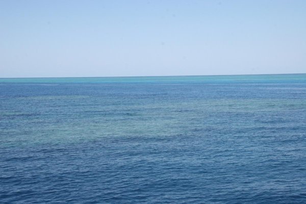
There is a huge choice of where to visit. What you need is a set of flopper-stoppers (or a SeaKeeper!) as the swell comes over the reef at high tide. This is particularly true for the section I just completed as there was over 5m of tidal range. Earlier in the season, when the SE winds are often 15-20kn it would not be comfortable unless you had neap tides, and perhaps not even then.

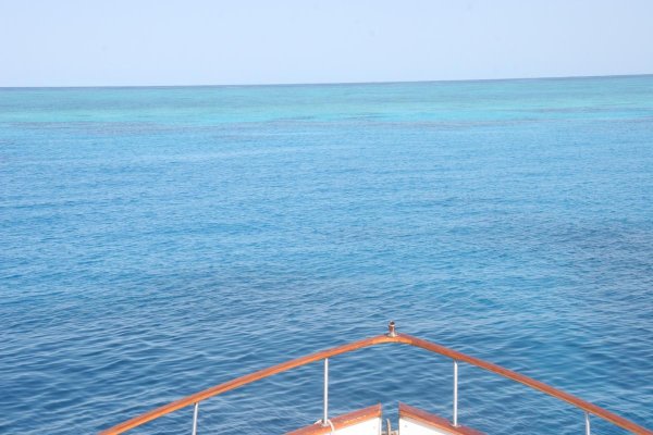
You also need enough rode to anchor in 30m depths, although I was not over 20m depth often. And all chain rode is best. You think you have found a flat bottom, but no idea whether is is deep reef or sand. Given there might be a wind shift, you put out good scope. Then you swing in gentle winds and later discover the rode has snagged on a patch of coral rising up 5m or so off the bottom that you did not know was there. That effectively gives a much steeper catenary (but still secure), and can give a lot of noise transmitted up the chain to the bow roller. Anchor recovery is usually quite easy - just go up to where the chain is vertical above the coral patch, take up the slack and the bow moving up and down a bit will shake the chain off the coral. But you would not want to have rope down there for that!
 
Last edited:
Brian, if this is not your first reef visit, from your snorkelling experiences can you comment on the condition of the reef compared to past visits?
 
Bruce

Two years ago I went as far north as Otter Reef, east of Cardwell. At that time the northern areas had some bleaching, and fluorescent-coloured (stressed) coral. It improved as I went south.

This time, when at Lizard Island the Research Station people were saying that over the past four years they had had two cyclones and two bleaching events. And yet the coral was still fair, and obviously recovering reasonably well. It seemed to improve, in terms of abundance and diversity as I went south, until getting towards the Whitsundays where cyclone Debbie really smashed it. Still, apart from a lot of coral debris in the shallower areas it was also resilient. This time one of the best areas of coral I saw was at Trunk Reef, east of Hinchinbrook Island. It was amazing diversity and abundance.

I had an interesting chat with the Bosun at Yorkeys Knob Boat Club. He has lived in the Cairns area all his life, and has been boating the whole time. He said that it seems to go in 10 year cycles. One area might be smashed for one reason or another but 10 years later is outstanding. And the poor/good areas are not necessarily that far apart and are not that extensive at any time. My own visits are very much 'limited random samples', but I think he may be right. Of course if the frequency of cyclones and bleaching increases compared to historical levels then things might start going downhill big time. At present, with a bit of local knowledge, I think you could pretty much visit anywhere along the length of the reef and see areas of healthy coral.

Resort infrastructure on the other hand is very hit & miss. Only a few have fully rebuilt, some are still building and not yet open, and some have not even started to clean up the debris from the cyclone damage.

What is apparent is that the greenies screaming 'the reef is dead/stop global warming/stop coal mining/ban farting etc' have absolutely no idea. They did a lot of damage to tourism in particular by ignoring the truth, not doing any real research or fact-finding and just pushing their own agenda.
 
Last edited:
I'm going to spend a few nights now in the Keppel group. I am glad I retreated from the outer reef when I did. The northerlies became brisk, but tomorrow very brisk SE winds and storms are forecast! So I'll relocate from S side of North Keppel to the W side of Great Keppel for a start but then move to N side of Great Keppel once there is no further likelihood of northerlies. The various weather models are conflicting at present. So after some maintenance was completed I thought I should add some more pics!

First is a screenshot of the Storm Reef area. With N to NW winds forecast, and most of the water depths near the reef being over 40m, so there was no obvious perfect anchorage. But then I looked at Google maps (offline) satellite image of the area (pic 2) and noticed there was a semi-enclosed lagoon in the patch or reef to the NE of Storm Reef. I found 20m depths inside, mostly flat bottom. It almost glassed-out for a while, but wind did pick up to 10 kn later.

Pic 3 is looking NE from where I anchored, about 45 minutes before low tide. At low slack there was about 0.5m of reef emergent. This is the area I snorkelled. Pic 4 shows the reef wall from surface down to about 10m depth. The other pics show a bit of the reef and the small fish in the area.
 

Attachments

  • Storm Rf chart.jpg
    Storm Rf chart.jpg
    127.2 KB · Views: 69
  • Storm Rf sat.jpg
    Storm Rf sat.jpg
    40.6 KB · Views: 69
  • N Storm Rf 1 sml.jpg
    N Storm Rf 1 sml.jpg
    50.4 KB · Views: 69
  • NE Storm Rf 7 sml.jpg
    NE Storm Rf 7 sml.jpg
    136.9 KB · Views: 72
  • NE Storm Rf 1 sml.jpg
    NE Storm Rf 1 sml.jpg
    202.4 KB · Views: 68
  • NE Storm Rf 2 sml.jpg
    NE Storm Rf 2 sml.jpg
    198.6 KB · Views: 70
  • NE Storm Rf 5 sml.jpg
    NE Storm Rf 5 sml.jpg
    188.5 KB · Views: 71
  • NE Storm Rf 8 sml.jpg
    NE Storm Rf 8 sml.jpg
    181.8 KB · Views: 73
  • NE Storm Rf 10 sml.jpg
    NE Storm Rf 10 sml.jpg
    200.2 KB · Views: 67
  • NE Storm Rf 11 sml.jpg
    NE Storm Rf 11 sml.jpg
    202.4 KB · Views: 68
I'm going to spend a few nights now in the Keppel group. I am glad I retreated from the outer reef when I did. The northerlies became brisk, but tomorrow very brisk SE winds and storms are forecast! .

Let the rolling begin

Keppels were one of our favourite cruising spots ever........when we had a boat that could float on a heavy dew.
Now we draw 6ft it didn't work as well for us and I never really noticed before how far out the shallows go.

Stay safe in the storms, BOM called and got tornadoes today........in Australia.:ermm:
 
Brian, There are some nice hidey holes in those Storm Reef surrounding reefs.
Good entrances and pretty safe inside.
Bur as usual they take some time to scout out and try.
Looks like you have had a great north cruise.
Did not even leave Moreton Bay this year, first time in 25 years.
Sounds like everything is working well.
 

Latest posts

Back
Top Bottom