ICW Jacksonville

The friendliest place on the web for anyone who enjoys boating.
If you have answers, please help by responding to the unanswered posts.

GMB

Veteran Member
Joined
Dec 30, 2012
Messages
41
Location
US
Vessel Name
Joy Shared
Vessel Make
Gulfstar 44 Motor Cruiser
I have heard that the entry to the ICW southbound from the St Johns River is tricky. Does anyone have recent experience? Are Nav aids correctly placed? Is a favored side approach needed ? We have 4ft draft. Looks like we'll be there at or just after high tide.
 
I have heard that the entry to the ICW southbound from the St Johns River is tricky. Does anyone have recent experience? Are Nav aids correctly placed? Is a favored side approach needed ? We have 4ft draft. Looks like we'll be there at or just after high tide.

You do need to exercise care in that area. The channel has changed over time, most recently more with Irma. The markers are back in decent shape, but many charts are not accurate. The other issue to be prepared for is that the current on the St. Johns can be very strong there flowing out, right in the area you're making your turn. Just proceed with care, keep your eyes on the markers and you should be fine.

Hopefully some who live in that area can add information.
 
I'll get back to you this afternoon. It was tricky coming south. Channel was far from the charts. See our tracks following the buoys.
 

Attachments

  • Jaxicw.jpg
    Jaxicw.jpg
    188.3 KB · Views: 160
Last edited:
This is less than a mile from the mouth of our lagoon.

Because of the deepening of the river to be able to accept the bigger ships coming through the new Panama Canal the ACE took away the small jetties that were protecting the mouth of the ICW south of the river. Clearly, while they could do all of the studies that they wanted, no one would know the impact until they actually did it.

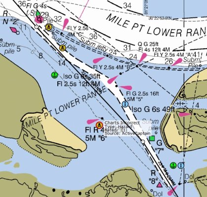
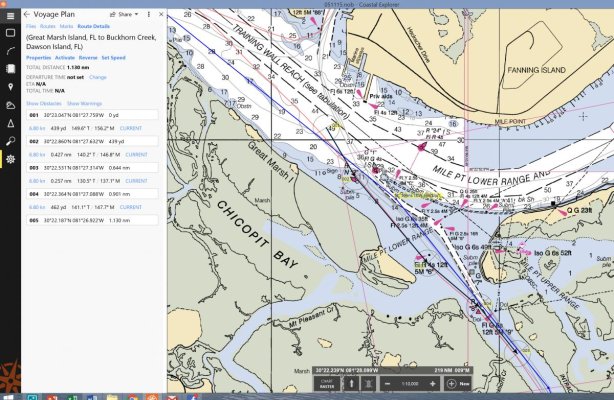
So where are we right now? Before you basically went right down the middle of the ICW, in fact the channel was not as narrow as depicted in the above chart, it was pretty deep and wide.

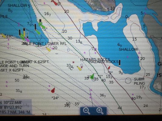
If you are approaching this part of the ICW, either form the north or south, you will think that one set of markers have been badly placed or moved. From the north it will look like the west side is Red, Red, Green, Red, and then, a set further south, the east side is Green, Green, Red, Green. They are not. That is because there is a sharp jog to the north west at one point. Pushing you close to the concreted edge of the ICW. Then it jogs east again. Simply trust the markers as they are laid out and you will be fine. I draw five foot and have no depth issues.

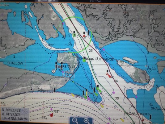
As mentioned, due to the removal of the jetties and the deepening of the river itself there is now a constant strong flow at the mouth of the ICW. At Springs this can be quite severe, but really something to be mindful of and ready for rather than dangerous as you are still in the (new part of the) deep river and there is plenty of room and depth where it happens so time and space to adjust if you have to.

Welcome to the hood, and what I believe is one of the most beautiful parts of the ICW, which many boaters miss going outside to St Augustine - and I include Palm Valley in that for first timers as the houses are pretty amazing - subsequent passages through there, not so much! :)
 
Last edited:
I agree its tricky, been reading charts a long time and that red bouy against the rocks threw me.

Hope it looks different headed North to better understand it.
 
We just did it the the 22nd of January. Follow the markers and you’ll be fine. We draw 5’. I think part of the confusion can the G4. It’s for the ICW and also for the ST John’s. The markers are all good. The current can push you around so keep your speed up. Here’s our track (green).
 

Attachments

  • F90029D3-8869-4435-B6F8-22C20D19767E.jpg
    F90029D3-8869-4435-B6F8-22C20D19767E.jpg
    193.5 KB · Views: 172
Larry, can you show your track further south as that is the most confusing part.
 
I’ll try. The Navionics were update this year. Again, the green track.
 

Attachments

  • 3A28AC80-96FA-438D-B65B-796C06EB42A8.jpg
    3A28AC80-96FA-438D-B65B-796C06EB42A8.jpg
    196 KB · Views: 186
Look at post #3 above...

Going south is easier than going North. If you are going North and miss the slight left turn at marker #5...with a fast outbound current...you will be swept over the submerged jetty to the right before you can take corrective actions.

As Forrest Gump says: "That's all I am going to say about that".

There is no longer a submerged jetty - the ACE removed all of that when they widened and deepened the river.
 
I was southbound in January and followed the markers and all went well with little to no anxiety. I draw 5’. The current is swift. Active Captain helps with this and other trouble spots as well.
 
I went through there twice last spring/summer. I didn't find it tricky but I didn't know it was supposed to be.

It pays to be on your toes whenever you are driving the boat but especially in situations like that, crossing a large river and watching for other traffic.
 
I went through there twice last spring/summer. I didn't find it tricky but I didn't know it was supposed to be.

It pays to be on your toes whenever you are driving the boat but especially in situations like that, crossing a large river and watching for other traffic.

You probably went through before the work was done to remove the jetties and before the post-work silting and channel shifting began. It is a different animal now unfortunately.
 
We came through February 5. We had the most up to date NOAA chart 11491 updated through January 13, 2018. We also had the latest Navionics updated charts. Neither chart agreed with each other on buoy placement and neither chart agreed with the buoys we actually saw in the water. But if you follow the buoys you will be fine.
 
We came through February 5. We had the most up to date NOAA chart 11491 updated through January 13, 2018. We also had the latest Navionics updated charts. Neither chart agreed with each other on buoy placement and neither chart agreed with the buoys we actually saw in the water. But if you follow the buoys you will be fine.

I agree, thats why it made me look twice and triple check coming through.

I was using an October NOAA chart coming through in December.
 
Here are waypoints from my transit 10 days ago.
 

Attachments

  • Jax pablo creek 2018-02-15 07.28.34.jpg
    Jax pablo creek 2018-02-15 07.28.34.jpg
    192.4 KB · Views: 133
Follow the markers. They're doing a good job of moving and placing them. The charts cannot keep up at this time.
 
We are planning a trip, in March, up the St Johns River from Astor to Jacksonville then south down the ICW. We aren't fast but hope not to have any problems in that area. Thanks for the heads up on the area.
 
I came through in November - headed south.

The buoys and charts did not agree and the local outboard folks were all following the old channel...

I figured they moved those buoys for a reason so I followed them. No problems.
 
There is no longer a submerged jetty - the ACE removed all of that when they widened and deepened the river.

When did they remove it? I know for a fact (don't ask) that it was there in 2007. But that is eleven years ago so even a hide bound federal agency could do something in that time. :socool:
 
just the last few years or less....
 
Back
Top Bottom