Laptops On Board

The friendliest place on the web for anyone who enjoys boating.
If you have answers, please help by responding to the unanswered posts.
Peter B wrote:Give me my mounted Lowrance, available at the flick of a switch, and back-up hand help Navman, (which has never been needed), any day.* I like simplicity....
******* That pretty much sums up my opinion, as well.
 
Regardless of the type of laptop, operating system, and nav application, the complaint I have heard most often about using a laptop is the readability of the screen in bright light. In a boat like a GB with its large windows all around the helm station, there are times when even our old CRT green-screen plotter can be tough to read. If the light is coming from in front so it's very bright out ahead of us, most screens-- purpose-built plotter or laptop--- simply can't be made bright enough to "balance" with the glare out front.

But when the light is coming from the side or rear, this is where the laptop screens seem to fall down. Any screen has a tough time under these circumstances but the backlit screen of a laptop or iPad seems particularly susceptible to this.

When we bought our big CRT plotter back in 1998 we ordered the optional sunshade for it, which makes a huge difference. Our much newer Furuno NavNet VX2 is on a retractable mount that comes down out of the overhead at the helm and so is fairly protected from light. Has any company come out with sunshades for laptops? That would seem to solve a whole lot of problems.
 
RickH wrote:
To Marin and others,

Our Sundowner raised pilothouse also has large windows and I use a Toshiba laptop with Costal Explorer.* You might take a look at one of these to reduce/eliminate the screen glare problem.

http://www.compushade.com/viewarticle.php?page=3&ref=24

Rick Haverstock

*
*

I use one of these (different brand) when I have the laptop on the flybridge.* It can still be a bit hard to see, but it's usable with the hood.* The biggest problem remaining problem was finding the mouse pointer.* Changing the default pointer to a larger arrow really helped.* Windows comes with several pointers to choose from.* A friend found, and downloaded a large red arrow to use on his laptop.
 
Thanks for the comments regarding power for a lap top but the rest of the comments I am afraid do not apply in my case. What I am using the lap top chart system for is to have a display of where we are in relation to what I can see out the windows without having to leave the helm and go to the chart table to read a full sized paper chart. I am sorry but I just do not trust the accuracy or reliability of any electronic chart system (that is affordable) to rely on it for my main navigation reference therefore Penta has a chart table large enough to hold full scale charts but due to her size there is not room enough for it to be adjacent to the helm so it was placed a bit aft over the dinette area and hinged from the ceiling so I have to step back from the helm to look at a chart.
The lap top is a Toshiba (a few years old) running Coastal Explorer and if it fails or I cannot see the screen due to the ambient lighting I will simply go back to using the paper charts as I have done for the past 20 odd years on Penta.
I guess to sum it up, the laptop is an added "convenience" item at the helm and will in no way be a prime navigation tool.
Thanks again for all the comments, interesting as always.

John MV Penta
Sidney, BC
 
Penta wrote:
I am sorry but I just do not trust the accuracy or reliability of any electronic chart system (that is affordable) to rely on it for my main navigation reference therefore Penta has a chart table large enough to hold full scale charts
*Well. every boater will use what they are the most comfortable with and it's rare that comments from other boaters who believe differently will change their minds. :)* 
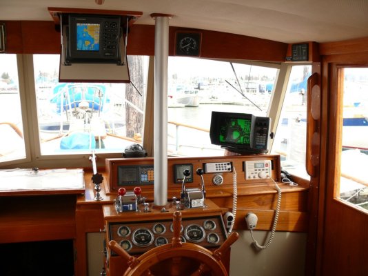
But we have been using elecronic navigation from the time we got our first boat, an Arima, in 1987.* Back then it was Loran-C.* Today, of course, it's GPS.* And while I won't use laptop-based navigation system for the reasons I've already described, I do believe that electronic navigation is every bit as accurate these days as charts.* We now have two (three, really) GPS-based, C-Map chart plotters on the boat.* We also have a chart board we modified that fits next to the helm station to hold the big MapTech-type chart-books for the areas we boat in here and in BC.* Underway, the board sits over the companionway to the forward cabin to the left of the helm station (see photo).

And, in the aft cabin out of the way, we carry the official NOAA and Canadian full-size charts for everywhere we go as there are some areas that are not covered by the big chart books.

We have found in the waters we boat so far-- which inlcluding our small-boat fishing goes from Possession Point at the south tip of Whibey Island to Knight Inlet and Blackfish Sound and the southern end of Queen Charlotte Strait that the electronic navigation from our purpose-built nav systems is every bit as accurate as the paper charts.*

The advantages we find in using electronic navigation over paper charts are far too numerous to list here, but I can think of only two advantages one gets from paper charts over an elecronic nav system.* The paper charts still work if the boat's electrical system fails, and paper charts can do a better and faster job of giving one an overall picture an area.* Since we have never had a power failure on either of our boats, the first advantage has not been one for us.* However we do use the paper charts for basic trip planning if we are going somewhere new and they definitely come in handy for giving us an overal picture when we want one.

We also use the paper charts on occasion to make sure in a tricky bit of water that there aren't any rocks or reeefs or other potential problems that aren't on the electronic charts.* So far, there never have been.

My wife and I both like and are comfortable using charts.* Me from flying and my wife from both flying and her US Navy days.* And we both simply like charts and maps.* So we like having them adjacent to the helm and we keep the correct page open for the area we're in.* But we use electronic charts for 100-percent of our navigation.

I know boaters who have no paper charts on board their boats at all, and so far so good for them for many,* many years.* I don't advocate this approach but it does illustrate the reliability and user-friendliness of electronic navigation.

I have on occasion plotted some of the courses we routinely follow on our paper charts to have as a backup in case the power should fail in poor visibility.* In my opinion, it's a major pain in the a*s.* It's like working out a complex calculation using a pencil and paper instead of a calculator.* If experience had shown that our electronic nav systems could not be trusted, the effort to plot and follow courses on the paper charts would seem more worthwhile.* But as we have never experienced a reliability or accuracy problem with any of the nav systems we have or have had, the case to actively use the paper charts simply isn't there for me.

I can only speak, of course, for the C-Map-based electronic charting systems we use.* I have not used any of the laptop-based systems like Nobletch, nor have I used Navionics, BlueCharts, or any of the other systems used by other makes of purpose-built plotters.* So I have no idea if they have accuracy and/or reliabitlity problems.* I've not heard that they do but since we are happy with C-Map we've had no reason to pay any attention to the other systems that are out there.

I think paper charts are cool in a sort of "historical roots" sort of way.* But I would not want to run a boat with them given what's available on a screen these days.


-- Edited by Marin on Monday 10th of October 2011 12:59:58 PM
 

Attachments

  • helm.jpg
    helm.jpg
    176.5 KB · Views: 78
Regarding the vessel lost to fire in Desolation Sound, it was the converted fish boat "Dagen" which was a member vessel of the West Coast Workboat Assoc. as well as being home and business for the owners. The last I heard they were still not certain what caused the fire however to the best of their knowledge the lap top was the only electronic device left running but it could very well have been another cause. I don't believe Capt. Leslie or her First Mate were able to get on board after they realized the fire had started because they lost everything including their cat to the fire. Being an older wood boat that was very well looked after I would imagine the wood was very dry and would have burned rapidly and fiercely.

John MV Penta
Sidney, BC
 
Penta wrote:
I am sorry but I just do not trust the accuracy or reliability of any electronic chart......._________________________________________________

Marin wrote:

I have not used any of the laptop-based systems like Nobletch, nor have I used Navionics, .............
I think paper charts are cool in a sort of "historical roots" sort of way.* But I would not want to run a boat with them given what's available on a screen these days.

*
SeaHorse II wrote:
My older brother used a slide ruler long after electronic calculators came out as he didn't trust them and thought they were a fad that would soon die.
I, on the other hand, have used both C-Map and presently Navionics. They are so accurate that, like Marin, I can't imagine running a boat with paper charts. (I do keep them on board, however.) As I've said in other threads, I love the combos & stand alone plotters.
*
 

Attachments

  • img_0192.jpg
    img_0192.jpg
    276.6 KB · Views: 75
Marin wrote:
I can think of only two advantages one gets from paper charts over an elecronic nav system.* The paper charts still work if the boat's electrical system fails, and paper charts can do a better and faster job of giving one an overall picture an area.

___________________________________________________________________

Agreed. And, of course, in the event the satellites fall out of the sky. We always have the Maptechs next to the chartplotter open to the area in which we are operating.
 
Back
Top Bottom