You are using an out of date browser. It may not display this or other websites correctly.
You should upgrade or use an alternative browser.
You should upgrade or use an alternative browser.
Can you identify this location?
- Thread starter bobc
- Start date
The friendliest place on the web for anyone who enjoys boating.
If you have answers, please help by responding to the unanswered posts.
If you have answers, please help by responding to the unanswered posts.
Nomad Willy
Guru
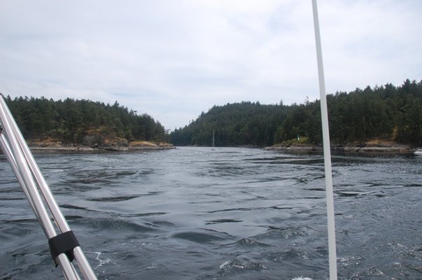
Second pic is Active Pass. Third is Tracy Arm south of Juneau. The last looks like San Juan or Gulf Island territory but I don't recognize it at all.
Walt, * Sounds like you had a great time beating the odds on your trip. I've never been the Johnston Strait route except by ferry. But I've run Yaculta in a 10 knot boat (max) with about 8.5 to 9 knots current. Took 45 minutes and 15% of the time the GPS said 0 speed fwd. Tidal currents generally are not a problem in the back channels. Ya go slow and ya go fast but that Yaculta experience was the only time I've been almost stopped. Just my experience and where I was and when I was there. Big Bay was the only place I can remember actually waiting for slack water. Planned not to be at Deception Pass at max current many times and spent the night at Bowman Bay to avoid max current. Keeping a straight course in whirlpools most of the time is watching the water over the bow moving sideways and going hard over w the helm and full throttle (especially if you have small rudders) at just the right time, usually a bit later than I expect.*
I'll wait till later today to post the picture locations ..weather permitting *...forecast is bad. Lots of guys know where these are. Those that have cruised SE will know these places like Tom White and Old Salt.
<table class="forumline borderline" style="font-size:12px;background-color:#0053a2;border-collapse:collapse;margin-bottom:10px;width:100%;border-width:1px;border-color:#0053a2;border-style:solid;" cellspacing="0" cellpadding="0"><tbody><tr class="tr tr-odd"><td class="row1 borderline comment-content" style="font-family:Verdana, Arial, Helvetica, sans-serif;border-collapse:collapse;background-color:#eff2f9;border-width:1px;border-color:#0053a2;border-style:solid;padding:4px;" valign="top"><table style="font-size:12px;width:1106px;padding:0px;margin:0px;"><tbody><tr><td style="font-family:Verdana, Arial, Helvetica, sans-serif;width:1102px;" colspan="2"><table style="font-size:12px;width:100%;" cellspacing="2" cellpadding="0"><tbody><tr><td style="font-family:Verdana, Arial, Helvetica, sans-serif;" colspan="2">
Marin this picture is absolutely stunning.
</td></tr></tbody></table></td></tr></tbody></table></td></tr></tbody></table>
-- Edited by nomadwilly on Saturday 8th of October 2011 11:12:19 AM
Nomad Willy
Guru
Well it looks like the interest in pictures went dead.*
My mystery pics are:
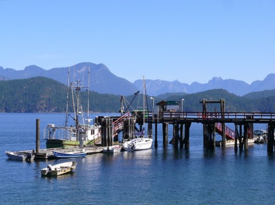
1. * Kake Alaska. West of Petersburg and north of Rocky Pass.
2. * Point Baker Alaska. On the NW corner of Prince of Wales Island.
My mystery pics are:
1. * Kake Alaska. West of Petersburg and north of Rocky Pass.
2. * Point Baker Alaska. On the NW corner of Prince of Wales Island.
rochepoint
Guru
- Joined
- Apr 4, 2009
- Messages
- 1,747
- Location
- Sidney BC, Canada
- Vessel Name
- Roche Point
- Vessel Make
- 1985 Cheer Men PT38 Sedan


bobofthenorth
Guru
- Joined
- Oct 18, 2009
- Messages
- 570
- Location
- Canada
- Vessel Name
- Gray Hawk
- Vessel Make
- Defever 43 Offshore Cruiser
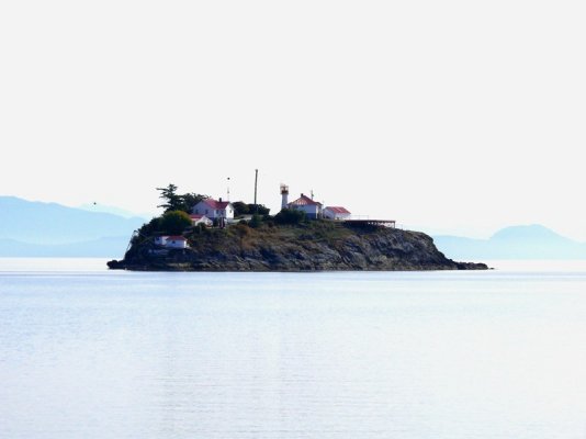
I'll play too - #3 looks like the end of Van Donop Inlet and #5 looks like Chrome Island light.
I think the first two are Dodd Narrows, first from the south, then from the north, the fourth one is definitely Squirrel Cove and the last one is definitely Chrome Island.
Below is a shot I took of Chrome the other year.* Anybody know where the next five are from?
*
Below is a shot I took of Chrome the other year.* Anybody know where the next five are from?
*
Attachments


markpierce
Master and Commander
- Joined
- Sep 25, 2010
- Messages
- 12,557
- Location
- USA
- Vessel Name
- Carquinez Coot
- Vessel Make
- penultimate Seahorse Marine Coot hull #6
No idea, but I love the looks of the float plane.
markpierce
Master and Commander
- Joined
- Sep 25, 2010
- Messages
- 12,557
- Location
- USA
- Vessel Name
- Carquinez Coot
- Vessel Make
- penultimate Seahorse Marine Coot hull #6
Guess whered (somewhere in Alaska).

*
*
It's an N3N-3, a trainer made by the Government Aircraft Factory. I believe it is the only plane, or at least the only successful plane, made by the US government itself. Made prior to WWII it was used by the Navy as a primary trainer both on wheels and on floats like this one.
rochepoint
Guru
- Joined
- Apr 4, 2009
- Messages
- 1,747
- Location
- Sidney BC, Canada
- Vessel Name
- Roche Point
- Vessel Make
- 1985 Cheer Men PT38 Sedan
#3 Squirrel Cove, #4 Squirrel Cove Government dock, #5 Pender Harbour and # 6 Refuge Cove.
Ok I give up where is two? My photos #1 Dodd Narrows from the south, #2 Dodd Narrows from the north, #3 Prideaux Haven, #4 Squirrel Cove, #5 Von Dunop and #6 Chrome Island.
Ok I give up where is two? My photos #1 Dodd Narrows from the south, #2 Dodd Narrows from the north, #3 Prideaux Haven, #4 Squirrel Cove, #5 Von Dunop and #6 Chrome Island.

bobofthenorth
Guru
- Joined
- Oct 18, 2009
- Messages
- 570
- Location
- Canada
- Vessel Name
- Gray Hawk
- Vessel Make
- Defever 43 Offshore Cruiser
*I think you can see it if you go to Hospital Bay in Pender Harbour.* And I believe its an N3N.markpierce wrote:
No idea, but I love the looks of the float plane.
*I think you can see it if you go to Hospital Bay in Pender Harbour.* And I believe its an N3N.bobofthenorth wrote:markpierce wrote:
No idea, but I love the looks of the float plane.
Yes, it is. It's an N3N-3.* I'm told it that it can still fly.* Judging by some small print on the plane, I think it's owned by a sort of historical association.* It's kept in a ramshackle hangar on the dock (to the left in the photo) and is rolled out on a railcar to a small derrick which launches and retrieves it.* We dinghied around from where we were anchored Garden Bay to see it but there was nobody around so I couldn't learn much about this particular plane's history.
Attachments

bobofthenorth
Guru
- Joined
- Oct 18, 2009
- Messages
- 570
- Location
- Canada
- Vessel Name
- Gray Hawk
- Vessel Make
- Defever 43 Offshore Cruiser
Giggitoni
Guru
- Joined
- Jun 21, 2008
- Messages
- 2,092
- Location
- United States
- Vessel Name
- Mahalo Moi
- Vessel Make
- 1986 Grand Banks 42 Classic

bobofthenorth
Guru
- Joined
- Oct 18, 2009
- Messages
- 570
- Location
- Canada
- Vessel Name
- Gray Hawk
- Vessel Make
- Defever 43 Offshore Cruiser
Here's 3 more - I'll give up that they're all in the vicinity of Desolation Sound.


rochepoint
Guru
- Joined
- Apr 4, 2009
- Messages
- 1,747
- Location
- Sidney BC, Canada
- Vessel Name
- Roche Point
- Vessel Make
- 1985 Cheer Men PT38 Sedan
#1 Refuge Cove, #2 Pendrell Sound..?, and #3 Roscoe Bay
markpierce
Master and Commander
- Joined
- Sep 25, 2010
- Messages
- 12,557
- Location
- USA
- Vessel Name
- Carquinez Coot
- Vessel Make
- penultimate Seahorse Marine Coot hull #6
*I think you can see it if you go to Hospital Bay in Pender Harbour.* And I believe its an N3N.Marin wrote:bobofthenorth wrote:markpierce wrote:
No idea, but I love the looks of the float plane.
Yes, it is. It's an N3N-3.*...
*Did a bit of research.* Several hundred were made.* One was used in Hitchcock's North by Northwest to buzz the hero. ...* Anyone out there have a TBF?
bobofthenorth
Guru
- Joined
- Oct 18, 2009
- Messages
- 570
- Location
- Canada
- Vessel Name
- Gray Hawk
- Vessel Make
- Defever 43 Offshore Cruiser
#2 was behind Elworthy Island on the south side of Waddington Channel. There's room for four or maybe five boats as long as they stern tie to the island. And yes, Refuge Cove and Roscoe Bay. We loved Roscoe Bay - the entrance likely keeps a lot of people out but it doesn't need to.
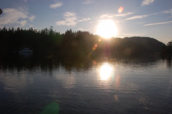
Before we get too far away from them, the photos I posted on page three are (after the Seal Cove floatplane base photo), Active Pass in the Gulf Islands, the LeConte Glacier near Petersburg, and Silva Bay on Gabriola Island in the Gulf Islands.
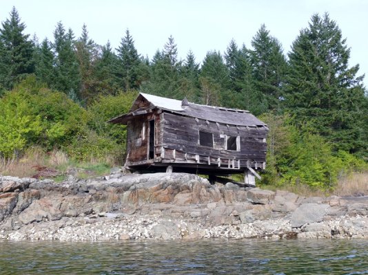
The photos of the little*weatherbeaten, beached floathouse and our GB rafted with a sailboat are both from Grace Harbor in Desolation Sound.
-- Edited by Marin on Monday 10th of October 2011 08:33:10 PM
The photos of the little*weatherbeaten, beached floathouse and our GB rafted with a sailboat are both from Grace Harbor in Desolation Sound.
-- Edited by Marin on Monday 10th of October 2011 08:33:10 PM
rochepoint
Guru
- Joined
- Apr 4, 2009
- Messages
- 1,747
- Location
- Sidney BC, Canada
- Vessel Name
- Roche Point
- Vessel Make
- 1985 Cheer Men PT38 Sedan
Shhhhhh..........thats a secret, beautiful anchorage with a great swimming lake!
markpierce
Master and Commander
- Joined
- Sep 25, 2010
- Messages
- 12,557
- Location
- USA
- Vessel Name
- Carquinez Coot
- Vessel Make
- penultimate Seahorse Marine Coot hull #6
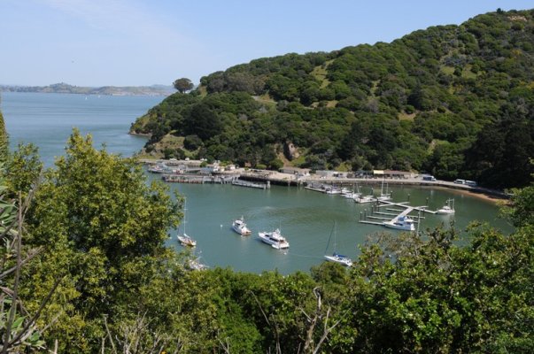
*Haven't yet figured out what picture you're referring to, but the northeast end of Angel Island is the landform on the left of this photo.Marin wrote:
Ray--- I haven't been there since I was a wee kid living in Sausalito, but is your first photo by chance Angel Island?

(Sure hope RickB doesn't monitor this thread.**His snipes are tiresome.)
*
-- Edited by markpierce on Monday 10th of October 2011 09:00:20 PM
Giggitoni
Guru
- Joined
- Jun 21, 2008
- Messages
- 2,092
- Location
- United States
- Vessel Name
- Mahalo Moi
- Vessel Make
- 1986 Grand Banks 42 Classic
Marin, you got it! The first photo is Ayala Cove on the north side of Angel Island. Richmond is in the background. The second?
-- Edited by Giggitoni on Monday 10th of October 2011 09:21:50 PM
-- Edited by Giggitoni on Monday 10th of October 2011 09:21:50 PM
markpierce
Master and Commander
- Joined
- Sep 25, 2010
- Messages
- 12,557
- Location
- USA
- Vessel Name
- Carquinez Coot
- Vessel Make
- penultimate Seahorse Marine Coot hull #6
*That's easy for me.* That's the lighthouse complex on the Brothers betwixt San Francisco and San Pablo Bays.Giggitoni wrote:
Marin, you got it! The first photo is Ayala Cove on the north side of Angel Island. Richmond is in the background. The second?
-- Edited by Giggitoni on Monday 10th of October 2011 09:21:50 PM

(Looking south.)
Giggitoni
Guru
- Joined
- Jun 21, 2008
- Messages
- 2,092
- Location
- United States
- Vessel Name
- Mahalo Moi
- Vessel Make
- 1986 Grand Banks 42 Classic
That's right, Mark. You captured your image from the west side of the island. The Brothers is about 1,000 feet west of Point San Pablo and defines the ancient western boundary of the Sacramento River trace during the last Ice Age. The water depth between the island and Pt. San Pablo exceeds 130 feet. Pretty darn deep for a bay that averages 15 feet! The ancient trace of the Sacramento River also ran between Angel Island and Point Tiburon; Raccoon Strait. The water depth in Raccoon Strait is up to 170 feet.
Similar threads
- Replies
- 8
- Views
- 1K