You are using an out of date browser. It may not display this or other websites correctly.
You should upgrade or use an alternative browser.
You should upgrade or use an alternative browser.
Can you identify this location?
- Thread starter bobc
- Start date
The friendliest place on the web for anyone who enjoys boating.
If you have answers, please help by responding to the unanswered posts.
If you have answers, please help by responding to the unanswered posts.
Island Cessna
Senior Member
- Joined
- Feb 19, 2011
- Messages
- 307
Sucia Island?
The first three are from the same general area and should be pretty easy for anyone who's cruised there.* The fourth photo is closer to home but I suspect will be a lot harder to figure out.bobc wrote:
Do you have other "Name that place shots"?
Attachments

bshanafelt
Senior Member
- Joined
- Oct 6, 2007
- Messages
- 427
- Vessel Name
- Isobel K
- Vessel Make
- 37' Custom Pilothouse
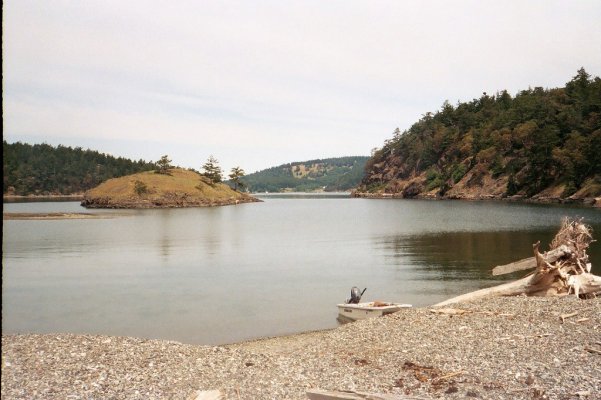
eagle harbor
love the free bouy
love the free bouy
OP
OP
bobc
Senior Member
You win the prize!* How'd you know what the prize was?* This was my first time visiting Cypress.* This shot was taken a few weeks ago.* I hope to go back when I have more time to explore the trails.bshanafelt wrote:
eagle harbor
love the free bouy
Eagle Harbor is neat. We went there for the first time this past spring and intend to go back this fall and winter when the crowds are gone. We're told the views from the top of the big hill are great but I think that particular trail is closed in the winter.
2bucks
Guru
- Joined
- Oct 6, 2007
- Messages
- 698
The giveaway was that you're in only 20 feet of water. The inside bouys are in 5 feet at low tide. Same place, different angle.
*
-- Edited by 2bucks on Wednesday 28th of September 2011 03:20:34 PM
-- Edited by 2bucks on Wednesday 28th of September 2011 03:21:27 PM
*
-- Edited by 2bucks on Wednesday 28th of September 2011 03:20:34 PM
-- Edited by 2bucks on Wednesday 28th of September 2011 03:21:27 PM
Attachments
OP
OP
bobc
Senior Member
I took the dinghy ashore in Eagle Harbor at low tide and had a hard time landing. I rowed in, but still ran out of water several feet from dry land. I finally found a spot to land on the southwest corner.
Marin, you're going to have to give us some more hints, I'm afraid. I'm guessing the first three pictures are somewhere north of Vancouver. The peak in the distance on the fourth picture looks like it might be Mt Erie, but I haven't got a clue as to what harbor that's in. The docks should be a dead giveaway.
Marin, you're going to have to give us some more hints, I'm afraid. I'm guessing the first three pictures are somewhere north of Vancouver. The peak in the distance on the fourth picture looks like it might be Mt Erie, but I haven't got a clue as to what harbor that's in. The docks should be a dead giveaway.
We found the best place to land in Eagle Harbor is on the little beach on the west side instead of the larger beach at the head of the bay.* Even at low water, getting up to the little beach in the dinghy*is easy.
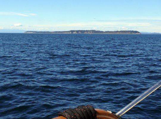
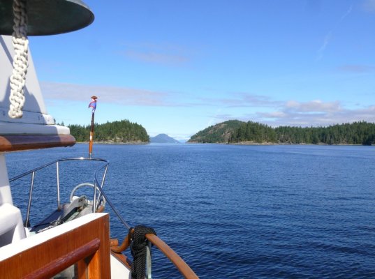
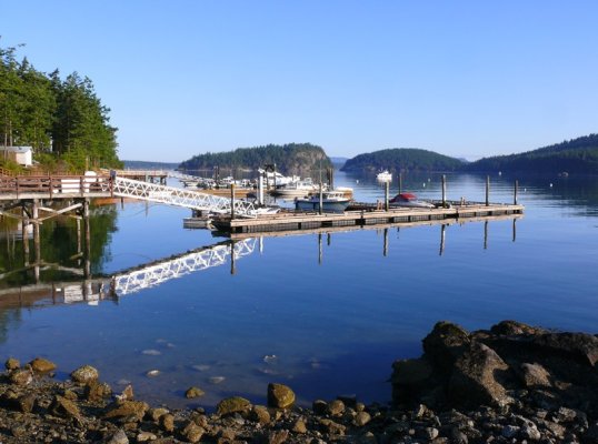
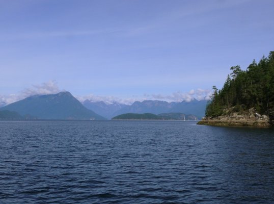
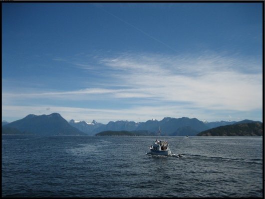
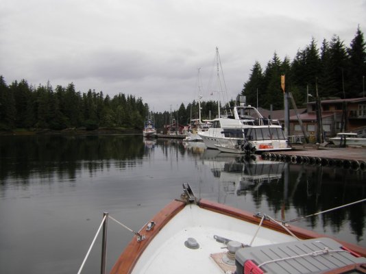
THe first three of my photos were all taken north of Powell River.* The first one marks a big moment in every northbound boater's journey.* The second photo is something that's talked about a lot in the book "Spillsbury's Coast."* The third photo is approaching an entrance from the inside and there are lots of rocks and ledges between our boat and the gap in the distance.
Mt. Erie is not in the fourth photo but you're in the right neighborhood.
*
-- Edited by Marin on Wednesday 28th of September 2011 10:20:16 PM
OP
OP
bobc
Senior Member
Marin, I give. I haven't cruised up North, so I don't really know the Powell River area. I tried to find something matching the 4th picture using Google Maps, but can't. It looks like a nice spot.
When I used to fly in Hawaii you could show me a photo of a small section of island coastline from any of the islands and I could immediatly name exactly where it was.* But it's a lot different looking at things from a boat, especially in the huge complex of islands, channels, and bays from here on north.* If I hadn't taken the photos I doubt I could identify any of the first three photos either except possibly the second one, and that only because I've read so many books about this particular area.
The first shot is Sarah Point at the top end of the Malaspina Penninsula.* The penninsula itself is pretty featureless as you cruise along the west side of it toward Desolation Sound. Then you get to Sarah Point and the islands and the coast range all appear as you turn the corner.
The second photo is Savary Island, which is why I made the referece to the book Spillsbury's Coast.* The author grew up on this island.
The third photo is really tough unless one knows the area fairly intimately.* It's the top end of Malaspina Inlet, approaching the entrance to the inlet from the inside.* So the boat is heading northwest.* We had spent some time in Grace Harbor, which is reached from the inside of Malaspina Inlet and we were on our way to Prideaux Haven when I took this shot.
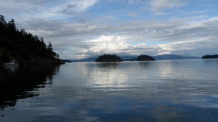
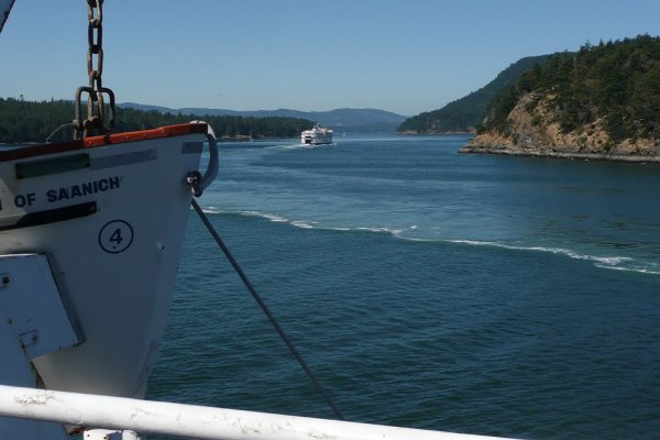
The fourth photo, while close to home, would be really tough for even long-time boaters in this area to identify because they would have no reason to go here.* It's Reads Bay at the south end of Decatur Island, between Decatur and Center Island.* We have property on Center and take the boat down there regularly (our boat is in the distance in the photo).* All the land on Center and Decatur is private with no access for the public.* All the docks and mooring buoys on both shores are private as well.* The docks in the photo are the Center Island Association docks.* The little white building on shore houses Center Island's reverse-osmosis desalinization plant, the first one to be installed in the San Juans.* It has recently been doubled in capacity and it provides so much potable water that the island's wells have no longer needed except for emergency backup from the day the original plant went on line.*
It's a wonderful place to go because with no public*shore access and no mooring facilities other than anchoring, the only boats and boaters back here are local.* The foot ferry Paraclete comes through a few times a day to pick up and drop off property owners at Center and over at the Decatur Shores dock on the other side.
First photo is the view from the mooring buoys.* Lopez Sound is in the distance to the left.* Second shot is our boat with some of the Decatur Shores houses in the background.
*
-- Edited by Marin on Tuesday 4th of October 2011 10:17:48 PM
The first shot is Sarah Point at the top end of the Malaspina Penninsula.* The penninsula itself is pretty featureless as you cruise along the west side of it toward Desolation Sound. Then you get to Sarah Point and the islands and the coast range all appear as you turn the corner.
The second photo is Savary Island, which is why I made the referece to the book Spillsbury's Coast.* The author grew up on this island.
The third photo is really tough unless one knows the area fairly intimately.* It's the top end of Malaspina Inlet, approaching the entrance to the inlet from the inside.* So the boat is heading northwest.* We had spent some time in Grace Harbor, which is reached from the inside of Malaspina Inlet and we were on our way to Prideaux Haven when I took this shot.
The fourth photo, while close to home, would be really tough for even long-time boaters in this area to identify because they would have no reason to go here.* It's Reads Bay at the south end of Decatur Island, between Decatur and Center Island.* We have property on Center and take the boat down there regularly (our boat is in the distance in the photo).* All the land on Center and Decatur is private with no access for the public.* All the docks and mooring buoys on both shores are private as well.* The docks in the photo are the Center Island Association docks.* The little white building on shore houses Center Island's reverse-osmosis desalinization plant, the first one to be installed in the San Juans.* It has recently been doubled in capacity and it provides so much potable water that the island's wells have no longer needed except for emergency backup from the day the original plant went on line.*
It's a wonderful place to go because with no public*shore access and no mooring facilities other than anchoring, the only boats and boaters back here are local.* The foot ferry Paraclete comes through a few times a day to pick up and drop off property owners at Center and over at the Decatur Shores dock on the other side.
First photo is the view from the mooring buoys.* Lopez Sound is in the distance to the left.* Second shot is our boat with some of the Decatur Shores houses in the background.
*
-- Edited by Marin on Tuesday 4th of October 2011 10:17:48 PM
Attachments


OP
OP
bobc
Senior Member
I wouldn't have figured that out. From the picture I thought I was looking out of a small harbor. In fact, I had suspected the little bay at the South tip of Decatur, but I couldn't see any docks that matched the picture. You're right about no reason to go there. I've always past Center Island to the West. I've anchored in nearby Hunter Bay several times. The next trip through Lopez Pass I think I swing in there for a look. Do you take the southern exit out of Reads Bay? It looks a bit shallow.
Boats like ours can go through the narrow southern pass but be very careful entering the bay itself (or exiting it through the pass).* A very shallow bar extends a long way into the bay from just south of the Center Island Association docks.* If it's a minus tide I'd be leary of going through there at all as based on the depth sounder on our dinghy there are some big humps of bottom that come up between the south shore of Center and the south end of Decatur.
The bay itself has good holding in a mud bottom although you can't go ashore anywhere unless you're a property owner.* There is a marked (but not very well) power cable crossing from the long bar over to Decatur.* The more obvious sign is on the Center Island end.* There a lot of private mooring buoys along the east side of Center and the west side of Decatur Shores.
The bay is well protected from the east, south, and west.* Not so much from the northwest if the wind picks up from that direction as there's a pretty long fetch across Lopez Sound and Read's Bay.* It can bounce you around pretty good.
There is a small but popular little anchorage south of Center tucked into the southwestern end of Decatur just inside Lopez Pass.* There are often two or three boats there stern tied to the little island in the cove.* This is the island with the famous "nobody has a clue what it is" concrete blockhouse structure on it.* The big gravel berm that separates this cove from Rosario Strait is accessible to the public so far as I know.* The whole south tip of Decatur is a wildlife preserve.*
Be very, very careful if you decide to anchor in there (if you haven't already and so are aware of this) because the little cove goes dry or nearly so at low tide between the island and the gravel bar.* We've seen a few sailboats aground and leaning over at a pretty severe angle when the tide went out.
If you anchor in Read's Bay be aware you'll probably get hit by a fair number of boat wakes during the day from the locals (and the Paraclete).* Most of the boats are smaller--- 16-25 feet--- but they can put out quite a wake if they're plowing or coming on or off the plane.** We're use to it but we've had friends come down in their boats and they didn't care too much for it.* Don't raft on your or someone elses's anchor--- your boats could take something of a beating.
The photo is from the big gravel berm and shows the little cove, the "concrete mystery" island, Center Island in the left background, and Read's Bay and the main part of Decatur with the sheep pasture on the hill*off to the right.
*
-- Edited by Marin on Tuesday 4th of October 2011 11:27:14 PM
Attachments
Nomad Willy
Guru
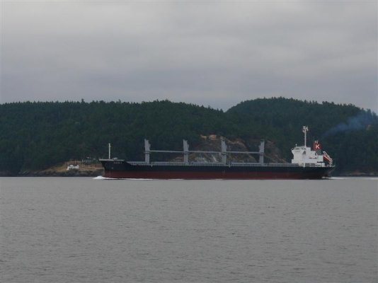
Yea *...Turn Point. Lotta ships make the big turn there. Been by it many times when we lived in Arlington and kept our boat in Everett and then LaConnor. We walked the beach just south of the point once *... assessed the beach walking over the island *...Henry ..I think.
Here's 3 even easier:
-- Edited by nomadwilly on Thursday 6th of October 2011 09:53:21 PM
Here's 3 even easier:
-- Edited by nomadwilly on Thursday 6th of October 2011 09:53:21 PM
Attachments
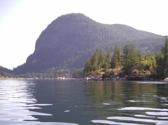


Eric--*Not at all confident about*the first one but it sure looks familiar. Is it at or near Prideaux Haven by chance?*
Second one is Butedale Cannery. That must be a pretty old photo as many of those buildings were gone or collapsing when we flew in there for the first time with the Beaver in 1985. I understand from friends who were there three years ago that there is almost nothing left now although there is still a caretaker. But I don't recall that the big building on the left was there in 1985.* Just the big concrete platform on piles that the buidling stood on. That first trip we tied the plane to a half-sunk dock in front of the store (building in front*on the right).**There were actually still a few items*on the shelves inside--- I recall jars of*mustard among other things---*although the store was closed and was starting to fall apart. *
In following years that dock was gone so*we'd land in the big*lake up behind the cannery (where the waterfall and*pipeline that*brings water to*the*turbine generator building come from)*and eat our picnic lunch.* Butedale was a good take-a-break point between Kenmore Air Harbor and Prince Rupert which was our destination for the day.
Third shot looks like Petersburg, not because I recognize the docks but because I recognize the hills on the other side of the channel.* I've landed in that channel more times than I can remember.
Keith--- This*is entering Desolation Sound after passing or rounding Sarah Point at the tip of the Malaspina Peninsula.
*
-- Edited by Marin on Friday 7th of October 2011 01:14:16 AM

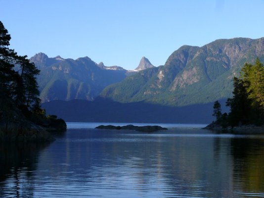
*Walt--- The first glimpse one gets of the Desolation Sound area is pretty dramatic isn't it?* It's made more so by the fact that if you go up to Desolation Sound by hugging the east side of Georgia Strait, the so-called Sunshine Coast, the view you have most of the way up is somewhat blah.* Low, tree-covered hills coming down to the water.* For part of the journey you are between the mainland and Texada Island, which is long and seems endless as you creep along at 8 knots.SeaHorse II wrote:
I'm not famliar with the photo areas you guys are posting but this photo really stirs my blood.
As you go north the shore to your right* becomes the Malaspina Peninsula.* On the other side of it out of sight is Malaspina Inlet, but the shoreline you are following remains unchanged.* Then you get to the top of the Penninsula and as you pass it, this is what you see.* If you're in close to shore as we usually are, it's like a curtain opening to reveal Desolation Sound.*
It was named, by the way, by Capt. Vancouver who, if you believe some of the accounts about him, was a rather weird guy.* He suffered from major mood swings from positive to negative and at times could be downright depressing.* If this is true, my guess is he named the Sound during one of these times.*
Even today, one is struck by the apparent lack of "life" in this area.* We have always gone in September so perhaps that makes a difference, but we have seen very little wildlife compared to farther south in the Gulf Islands.* We have seen only one eagle up there for example.* Of course in September the eagles are starting to congregate on the rivers for the salmon so that may be a factor.* Ravens are plentiful enough-- -you hear them everywhere if not see them.* But they can sound really spooky if they want to. We've seen a deer at Prideaux Haven. And there is certainly plenty of life in the water.
The scenery is spectacular (although it gets even better as you go north toward Eric's neck of the woods).* But if you take away all the boaters and imagine the place as Vancouver saw it, when his "Discovery" and the little "Chatham" were the only two vessels there in this vast, silent basin with its jagged, rocky shoreines, I can see where the area could appear foreboading and desolate in terms of life.* Particularly if it was raining, which it probably was.
These photos were all taken in the same immediate area as Keith's, which I've included here, too.* Note the similarity to the second photo, which was taken from more or less the same place but right in next to Sarah Point.* If you've not had the opportunity to visit this area, it's well worth it.* There are lots of places to charter boats if you don't have your own up here.
-- Edited by Marin on Friday 7th of October 2011 01:54:36 PM
Attachments


Codger2
Guru
- Joined
- Oct 11, 2007
- Messages
- 6,691
- Location
- US
- Vessel Name
- Circuit Breaker
- Vessel Make
- 2021..22' Duffy Cuddy cabin
******* My only experience in the B.C. area was on a 57' Nordhavn, about 7 years ago. My wife and I flew into Campbell River, took a water taxi to April Point where we met the boat. (Quadra Island?)Marin wrote:*If you've not had the opportunity to visit this area, it's well worth it.* There are lots of places to charter boats if you don't have your own up here.
We cruised south for a short while, then turned east. (I have no idea what the names of these places are as I was busy holding up my lower jaw.) We anchored in a secluded cove where the entrance was slightly wider than the beam of the Nordhavn. The next morning we boarded the Grady White that we were towing* and went for a short spin. Dick pulled in to a marina of sorts and we bought some staples and topped off the Grady with gas.
That day we cruised on to Dent Island and Jim & Sally Nordstrom's lodge, where we tied up and spent the night. The going was really tough as we were met at the dock, approved for tying up and ask to fill out our dinner menue choices which included Pheasant Under Glass, Salmon/ Halibut and Filet Mignon. After showering, we all met on the lodge's deck for a cocktail and watched the guides running up a rapid and into the next bay, which they could only do during a tide change.
Answering the dinner bell, we proceeded to the dining room where open seating allowed us to all sit together and with whomever we chose. When the entrees came, they placed them ever so carefully in front of each of us and everyone got exactly what they had ordered when we were on the boat! I have asked, but never got an answer as to how they did that.
That was and is my only encounter with* the "ruggedness and wilderness" of B.C. I have spent quite a lot of time, however, in S.E. Alaska which is my favorite spot on the planet.
-- Edited by SeaHorse II on Saturday 8th of October 2011 08:43:10 AM
Attachments


Nomad Willy
Guru
Well I thought anybody that had been north would get all three. There so easy you're going to deflate when I tell you what they are. 1st is Big Bay at Yuculta Rapids. 2nd is Butedale like Marin says. I was there in 74 when the pelton wheel was still working and you could take 3 hr hot showers anytime. The third is Prince Rupert. PR Public floats. Lots of action there in the summer. So much so I've never tied to the floats. Always had to raft. These two new photos are off the beaten path and both in Alaska.*
Attachments

*You will have gone through part of Desolation Sound on this run.* I suspect that the marina of sorts you visited*with the*store and fuel*was Refuge Cove.SeaHorse II wrote:
We cruised south for a short while, then turned east. (I have no idea what the names of these places are as I was busy holding up my lower jaw.) We anchored in a secluded cove where the entrance was slightly wider than the beam of the Nordhavn. The next morning we boarded the Grady White that we were towing* and went for a short spin. Dicked pulled in to a marina of sorts and we bought some staples and topped off the Grady with gas.
I've not been to the Dent Island resort, although Kenmore flies in there, or used to if it's no longer operating as a lodge.* I have been into Big Bay Resort across the way several times back when it was in full operation.* It's closed as a resort now and has reverted to a private operation.* Big Bay was a major customer of Kenmore's for years.* Somewhere I have some photos I took on the way into a landing at Big Bay of the Yuculta Rapids in full flow.* With little fishing guide boats around the perimeter.* Very impressive sight.
*
Attachments

Eric--- *Prince Rupert.* Wow, I never would have guessed.* The channel and hills on the other side look exactly like Petersburg.* I've been into Prince Rupert, too, with the Beaver about a zillion times.* But the seaplane docks are around the corner in Seal Cove.* In the attached photo (off the web) the main channel and harbor is around the point on the left.nomadwilly wrote:
The third is Prince Rupert. PR Public floats.
I guess your first photo was familiar to me as a result of flying into Big Bay so many times.* But that was back in the 80s and 90s so I was thinking in terms of where we've been in the boat since then.
Your two new photos are total mysteries to me as the only places we've gone in SE Alaska have been in the plane.* So Ketchikan, Petersburg, Wrangel, Sitka, and Juneau as well as some of the lakes over on the mainland side up in the Coast Range and in Misty Fjords.* But wherever those two photos are, they look like great places to explore.
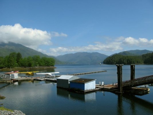
As long as we're playing "Stump the boaters," here are three more (after the Seal Cove picture).* I didn't take the first one, but it's closer to home than the other photos we've been posting.** I did take the second one, and while it's*not from a boat it should be familiar to people familiar with SE Alaska.* And I did not take the third one, but it, too, is closer to home.
*
-- Edited by Marin on Friday 7th of October 2011 10:14:12 PM
Attachments


Codger2
Guru
- Joined
- Oct 11, 2007
- Messages
- 6,691
- Location
- US
- Vessel Name
- Circuit Breaker
- Vessel Make
- 2021..22' Duffy Cuddy cabin
******* If Refuge Cove has a dock and fuel, that sure looks like the place.Marin wroteI suspect that the marina of sorts you visited*with the*store and fuel*was Refuge Cove.
While we were at Dent Island, a* float plane landed but as I recall it was not directly at the lodge but at a bay beyond the tree line. The rapids I was referring to were very close to the lodge. It may seem unusual that I didn't get the names of all these places but one had to be there to understand my situation. The owner of the boat was a good friend of mine with more money than boat knowledge or brains. On the way to Dent we had a hell uv a tide behind us and logs, tree stumps, etc. were coming very close to us and actually hit the Grady White.
The next day we headed back to April Point and went south in the Seymore Narrows. Dick did have the good sense to anchor at the north end of the Narrows and wait for a slack tide. The trip down the Narrows was a little hair raising, however, as I noticed the GPS was indicating 18 knots, in a boat that cruises at 8.5 knots. Several times the boat swung 90 degrees to the desired heading and I felt like we were on a raft, completely out of control. Just north of Campbell River the water settled quite a bit but it seems there were always small whirl pools.
Another thing that happened was that an ER check the first night showed that the transmission dip stick came loose and the drip pan below the Lugger was full of oil. Using a couple rolls of paper towels, I managed to clean it all up and ask Dick for the oil to replace what we had lost. He brought me a case of ATF and I just stared at him. I pulled out his manual on the Twin Disk transmission which indicated that regular engine oil should be used. He had a hard time accepting that but that is what we filled the transmission with. It held up for the rest of the summer and all the way to Seattle.
So, to conclude, the entire trip was filled with events such as this and the last thing I was thinking about before turning in was "where I had been during those days and what their names were."* :wtf:
*Yes, it does.* Actually it has three docks arranged in a big U-shape. The fuel is at the end of one of the legs of the U.* There are also several other homes and outbuildings perched on the rocks around the cove as well as on floats next to the docks.SeaHorse II wrote:
******* If Refuge Cove has a dock and fuel, that sure looks like the place.
Sounds like you had a rather harrowing voyage.* Most people wait for slack tide to run the Yuculta, Dent, and Arran rapids.* There are annually published tide and current books that tell you when the*slack and maximum ebb and flood current times are for all the main rapids.
Similar threads
- Replies
- 8
- Views
- 1K