I've used AC for 3-4 yrs now... submitted many reviews and earned my cap.
Started w/ laptop & wifi access to AC website - marina reviews etc helpful for route planning.
I learned that w/ the App on a tablet / phone I could download chart "Tiles" to allow access while offline - useful for quick checks while underway.
Last season I attempted to update an outdated tile only to find the no cost AC app no longer was supported and it wiped out the old (although still useful) AC data. I emailed AC any they indicated I could use any of the many apps listed on their website.
For background - I have a Raymarine MFD & chip for my cruising area - I am not looking to do route planning or nav w/ the App I don't need / want a new high end / multifunction nav program - I am only looking to access to AC marina / anchorage data & info.
So far I've downloaded & tried...
Locations - I can get on and display current location but can not get any AC info / data - I don't see any setting / layer drop down to select AC??
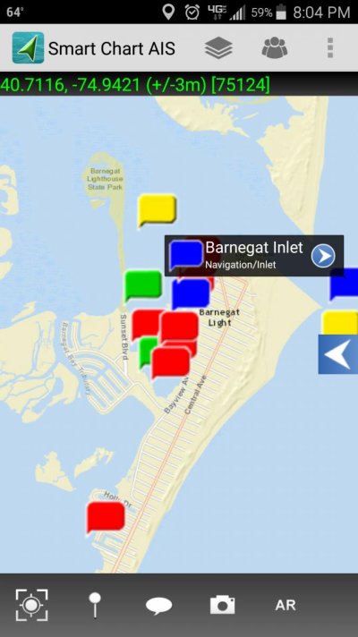
Smart Chart - Similar to locations - I can get on but can not find or access any AC marina data, reviews, etc
Note I have AC turned on in the Layers drop down - but still nothing showing?
Neither of the above have much in the way of help w/ set-up
Can anyone provide any insight / assistance w/ either of the Apps noted?
Can anyone recommend a No / Low Cost Android app that allows access to AC marine / anchorage info / reviews - I'm especially interested in downloading chart sections to allow offline access.
Started w/ laptop & wifi access to AC website - marina reviews etc helpful for route planning.
I learned that w/ the App on a tablet / phone I could download chart "Tiles" to allow access while offline - useful for quick checks while underway.
Last season I attempted to update an outdated tile only to find the no cost AC app no longer was supported and it wiped out the old (although still useful) AC data. I emailed AC any they indicated I could use any of the many apps listed on their website.
For background - I have a Raymarine MFD & chip for my cruising area - I am not looking to do route planning or nav w/ the App I don't need / want a new high end / multifunction nav program - I am only looking to access to AC marina / anchorage data & info.
So far I've downloaded & tried...
Locations - I can get on and display current location but can not get any AC info / data - I don't see any setting / layer drop down to select AC??
Smart Chart - Similar to locations - I can get on but can not find or access any AC marina data, reviews, etc
Note I have AC turned on in the Layers drop down - but still nothing showing?
Neither of the above have much in the way of help w/ set-up
Can anyone provide any insight / assistance w/ either of the Apps noted?
Can anyone recommend a No / Low Cost Android app that allows access to AC marine / anchorage info / reviews - I'm especially interested in downloading chart sections to allow offline access.