You are using an out of date browser. It may not display this or other websites correctly.
You should upgrade or use an alternative browser.
You should upgrade or use an alternative browser.
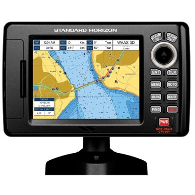
Standard Horizon CP190i
- Thread starter Marin
- Start date
The friendliest place on the web for anyone who enjoys boating.
If you have answers, please help by responding to the unanswered posts.
If you have answers, please help by responding to the unanswered posts.
Tom.B
Moderator Emeritus
- Joined
- Jul 30, 2009
- Messages
- 5,839
- Location
- USA
- Vessel Name
- Skinny Dippin'
- Vessel Make
- Navigator 4200 Classic
I am thinking of a plotter upgrade and SH is at the top of my list. I have heard great things about their customer service and that is a huge plus for me. (I am looking at the higher end models tho). The only problem is that the local marine stores don't stock them, so I really have to buy without being able to try them out first. That will be a little bummer for me. I am worried that some of the bigger models are jack-of-all-master-of-none. They have wi-fi, iPod, music, movies and all the bells and whistles. I worry about them trying too hard and falling a bit short. Still, I have heard good things about the smaller 190's.
FWIW after reading reviews of various units and talking to the owner of the marine electronics shop we use we decided to go with the CP190i.* One reason is that it uses C-Map cartography which we prefer over all the other chart applications we've seen to date.* The unit comes pre-loaded with the charts for all of the* US including the Great Lakes, Alaska and Hawaii, coastal Canada, the northern portion of South America, Mexico, Cuba, Central America, and the Caribbean.
The owner of the electronics shop said that in order to load that much data into the unit something had to go, so what went was all the depth and depth contour data deeper than 60 feet.* However if one wants the deeper water data or all the additional data available from C-Map the CP190i has a slot to accept C-Map NT+ and Max cards. The unit can display all this data, it just can't hold it on its own.
The CP190i has a built-in 50 channel WAAS GPS receiver which was another of our requirements as we did not want to have to mount a separate GPS antenna.* It can be connected to a stand-alone receiver, however.
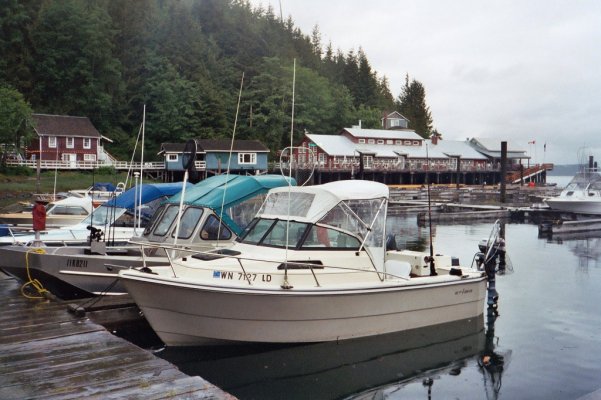
It's a small unit--- only a five inch screen--- so in my opinion would be very unsuitable as a primary plotter for a trawler-type cruiser.* But for a small boat like our 17' Arima fishing boat the reviews we read said it proved ideal.* I would imagine the unit would also be well suited for use as a plotter on a larger dinghy--- RIB, Boston Whaler, etc.* It will be replacing the Loran-C unit and the Magellan GPS plotter in the second photo.* So the small size of the CP190i is an advantage in this particular application.
We bought the basic plotter version but it can be had with a fishfinder function, it can display AIS information, and it be linked to a radar.* It is supposedly waterproof.
We bought an extra mount and power cable to put on the flying bridge of the GB.* We never run the boat from up there but when we take friends out they sometimes like to sit up there so having a plotter to show them where we are is nice--- we did the same thing with the Magellan 6000 in the photo.* But its primary use will be on the Arima.
At this point I can't offer any opinion pro or con as we haven't yet used it.* But in two weeks we are heading up the north end of Vancouver Island for our annual two-week halibut fishing trip with friends from France so we should have a pretty good idea if the plotter is good, bad, or indifferent after that.
I've got a project to direct in Shanghai immediately after the halibut trip but if anyone is looking for a small plotter for an application similar to ours and wants to know what we think of the CP190i after using it up north send me a PM and I'll respond to you when we get back from China.
-- Edited by Marin on Saturday 14th of May 2011 01:14:26 PM
The owner of the electronics shop said that in order to load that much data into the unit something had to go, so what went was all the depth and depth contour data deeper than 60 feet.* However if one wants the deeper water data or all the additional data available from C-Map the CP190i has a slot to accept C-Map NT+ and Max cards. The unit can display all this data, it just can't hold it on its own.
The CP190i has a built-in 50 channel WAAS GPS receiver which was another of our requirements as we did not want to have to mount a separate GPS antenna.* It can be connected to a stand-alone receiver, however.
It's a small unit--- only a five inch screen--- so in my opinion would be very unsuitable as a primary plotter for a trawler-type cruiser.* But for a small boat like our 17' Arima fishing boat the reviews we read said it proved ideal.* I would imagine the unit would also be well suited for use as a plotter on a larger dinghy--- RIB, Boston Whaler, etc.* It will be replacing the Loran-C unit and the Magellan GPS plotter in the second photo.* So the small size of the CP190i is an advantage in this particular application.
We bought the basic plotter version but it can be had with a fishfinder function, it can display AIS information, and it be linked to a radar.* It is supposedly waterproof.
We bought an extra mount and power cable to put on the flying bridge of the GB.* We never run the boat from up there but when we take friends out they sometimes like to sit up there so having a plotter to show them where we are is nice--- we did the same thing with the Magellan 6000 in the photo.* But its primary use will be on the Arima.
At this point I can't offer any opinion pro or con as we haven't yet used it.* But in two weeks we are heading up the north end of Vancouver Island for our annual two-week halibut fishing trip with friends from France so we should have a pretty good idea if the plotter is good, bad, or indifferent after that.
I've got a project to direct in Shanghai immediately after the halibut trip but if anyone is looking for a small plotter for an application similar to ours and wants to know what we think of the CP190i after using it up north send me a PM and I'll respond to you when we get back from China.
-- Edited by Marin on Saturday 14th of May 2011 01:14:26 PM
Attachments

JAT
Guru
I don't have a CP190i...seems that is the newest model... I have a CP180i that we have had for about a year and a half.... It looks identical to the 190i... I can tell you that it is a good little chart plotter... I liked it because it uses the same chip as my two Interphase GPS's.... I run two GPS's on the flybridge all the time.... and they, the CP180i and Interphase V6 were on the numbers together. I'm happy with my choice for a backup unit.
For anyone contemplating the acquisition of a small, self-contained GPS chart plotter for a fishing boat, RIB, etc, I thought I'd briefly comment on my experience thus far with the Standard Horizon CP190i.
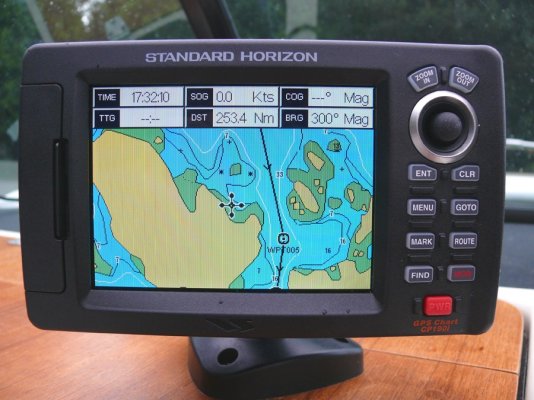
To start with, the display is extremely bright.* I mean REALLY bright.* Even in our Arima with the top down and the sun falling directly on the screen it was plenty bright enough even in the "normal" setting.* There is an even brighter "Sunlight" setting than this but we did not find it necessary.
The built-in cartography is C-Map which we feel is superior to all the others on the market and is one of the main reasons we selected this unit.* So far as I know C-Map is the only cartography available in the CP190i, so if you don't like C-Map cartography this is not a unit you'll be interested in.
When zoomed in to smaller areas the chart display is as detailed as the display on our Furuno NavNet VX2.* However as one zooms out smaller shorline details begin to be "smoothed over" sooner than they do when you zoom out on a larger plotter.* I assume this is due to the small (5") screen size on the CP190i.* Or it may be that this detail will not be lost if one uses the optional C-Map Max card in the unit.
The plotter can be oriented north up or course up. I tend to prefer north up, which is how we run the plotters on the GB.* But at 30 mph in the narrow, rock-strewn passes and channels around Knight Inlet and Blackfish Sound where we were fishing I found that course-up was the better way to go, particularly on those days we found ourselves fishing in dense fog.
There are several choices for the boat marker.* The default is a small planview of a motorboat.* A clever feature is the port half of the bow is red and the starboard half is green.* As insignificant as it seems this feature came in quite useful in the fog as added confirmation that we were turning the boat the correct direction, particularly on those times when turning in the wrong direction could have gotten us in real trouble real fast.
It seems that every plotter manufacturer has their own way of dealing with waypoints and routes and the CP190i has one I hadn't encountered before.* My favorite method is the one used by our Furuno in which you create waypoints and then use the master waypoint list to create routes.* So the same waypoint can be used in multiple routes.* With the CP190i you create a route by moving the cursor over the chart to where you want the first waypoint, entering it, then moving the cursor to where you want the next waypoint and entering it, and so on until you have built the route.* You then give the route a name.* Waypoints can be added, deleted, or moved once the route is made.
To make another route you do the same thing again, moving the cursor to the first waypoint and so on.* Even if the second route is going to start at the same place or follow some of the first route you still have to create the whole route from scratch.* However, unlike our old Echotec plotter on our GB which requires all routes to be created separately and displays all of them all the time, the CP190i only displays the route you have selected to follow.* So in that respect it's a big improvement over the Echotec display but it's not as user-friendly (in my mind) as the Furuno with its master waypoint list.
Granted, I haven't had that much time with the CP190i so there may be more sophisticated ways of dealing with routes than what I've learned so far.* You can also create marks on the chart display.* These act more like the Furuno's waypoint list in that the marks list can be used to create routes and the marks don't go away when a route is deleted.* So perhaps that's the better way to go, but I didn't have the time to get into that part of the CP190i's operation.
Like most electronics these days the CP190i is very much menu-driven.* The "joystick" cursor control is also the main way of moving around on the menus and it works very well.* For the most part menus are pretty intuitive once you learn the basic locations of things.* I didn't find I was constantly having to refer to the manual.
Like all C-Map cartography there are many layers of information that can be turned on or off so you can customize the display pretty much how you want it.* There are even options for what you want the charts to look like--- "Classic,"* "NOAA," etc.* The unit accepts a C-Map Max card which adds all the depth contour data deeper than 60' plus a huge array of C-Map features from photos of navaids and harbors to active flashing navaids.* A card is about $200.
However the built-in cartography is excellent and for the kind of thing we we doing up north it was more than sufficient for our needs.
Unfortunatly we had a motor problem with the main engine on the Arima and so were not able to get in as much fishing/boating as we'd anticipated.* So I have not had the experience using the CP190i that I'd hoped to have by now.* But based on our experience so far I am very happy with our decision to buy the unit and feel that for a small-boat application like ours it is ideal.* The unit has a built-in GPS antenna so it needs to be mounted in a location where the antenna can see the satellites.* However a remote antenna is available for the unit so the display unit can be mounted just about anywhere including flush in a panel.
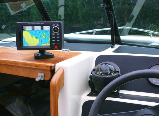
We* bought a second mount and power cord so we can mount the CP190i on the flying bridge of our GB on those occasions when we have guests who like to ride up there.* The extremely bright screen of the CP190i means it will be easily readable even up top in full sun.
The screen brightness setting in the two photos is "normal."* The vertical scan lines visible in the close-up are seen by the camera but are not visible to your eye.* I took the photos today when the boat was sitting in our driveway, hence the 253 nautical mile distance displayed which is how far it is from our driveway to the position of the cursor on the screen")
To start with, the display is extremely bright.* I mean REALLY bright.* Even in our Arima with the top down and the sun falling directly on the screen it was plenty bright enough even in the "normal" setting.* There is an even brighter "Sunlight" setting than this but we did not find it necessary.
The built-in cartography is C-Map which we feel is superior to all the others on the market and is one of the main reasons we selected this unit.* So far as I know C-Map is the only cartography available in the CP190i, so if you don't like C-Map cartography this is not a unit you'll be interested in.
When zoomed in to smaller areas the chart display is as detailed as the display on our Furuno NavNet VX2.* However as one zooms out smaller shorline details begin to be "smoothed over" sooner than they do when you zoom out on a larger plotter.* I assume this is due to the small (5") screen size on the CP190i.* Or it may be that this detail will not be lost if one uses the optional C-Map Max card in the unit.
The plotter can be oriented north up or course up. I tend to prefer north up, which is how we run the plotters on the GB.* But at 30 mph in the narrow, rock-strewn passes and channels around Knight Inlet and Blackfish Sound where we were fishing I found that course-up was the better way to go, particularly on those days we found ourselves fishing in dense fog.
There are several choices for the boat marker.* The default is a small planview of a motorboat.* A clever feature is the port half of the bow is red and the starboard half is green.* As insignificant as it seems this feature came in quite useful in the fog as added confirmation that we were turning the boat the correct direction, particularly on those times when turning in the wrong direction could have gotten us in real trouble real fast.
It seems that every plotter manufacturer has their own way of dealing with waypoints and routes and the CP190i has one I hadn't encountered before.* My favorite method is the one used by our Furuno in which you create waypoints and then use the master waypoint list to create routes.* So the same waypoint can be used in multiple routes.* With the CP190i you create a route by moving the cursor over the chart to where you want the first waypoint, entering it, then moving the cursor to where you want the next waypoint and entering it, and so on until you have built the route.* You then give the route a name.* Waypoints can be added, deleted, or moved once the route is made.
To make another route you do the same thing again, moving the cursor to the first waypoint and so on.* Even if the second route is going to start at the same place or follow some of the first route you still have to create the whole route from scratch.* However, unlike our old Echotec plotter on our GB which requires all routes to be created separately and displays all of them all the time, the CP190i only displays the route you have selected to follow.* So in that respect it's a big improvement over the Echotec display but it's not as user-friendly (in my mind) as the Furuno with its master waypoint list.
Granted, I haven't had that much time with the CP190i so there may be more sophisticated ways of dealing with routes than what I've learned so far.* You can also create marks on the chart display.* These act more like the Furuno's waypoint list in that the marks list can be used to create routes and the marks don't go away when a route is deleted.* So perhaps that's the better way to go, but I didn't have the time to get into that part of the CP190i's operation.
Like most electronics these days the CP190i is very much menu-driven.* The "joystick" cursor control is also the main way of moving around on the menus and it works very well.* For the most part menus are pretty intuitive once you learn the basic locations of things.* I didn't find I was constantly having to refer to the manual.
Like all C-Map cartography there are many layers of information that can be turned on or off so you can customize the display pretty much how you want it.* There are even options for what you want the charts to look like--- "Classic,"* "NOAA," etc.* The unit accepts a C-Map Max card which adds all the depth contour data deeper than 60' plus a huge array of C-Map features from photos of navaids and harbors to active flashing navaids.* A card is about $200.
However the built-in cartography is excellent and for the kind of thing we we doing up north it was more than sufficient for our needs.
Unfortunatly we had a motor problem with the main engine on the Arima and so were not able to get in as much fishing/boating as we'd anticipated.* So I have not had the experience using the CP190i that I'd hoped to have by now.* But based on our experience so far I am very happy with our decision to buy the unit and feel that for a small-boat application like ours it is ideal.* The unit has a built-in GPS antenna so it needs to be mounted in a location where the antenna can see the satellites.* However a remote antenna is available for the unit so the display unit can be mounted just about anywhere including flush in a panel.
We* bought a second mount and power cord so we can mount the CP190i on the flying bridge of our GB on those occasions when we have guests who like to ride up there.* The extremely bright screen of the CP190i means it will be easily readable even up top in full sun.
The screen brightness setting in the two photos is "normal."* The vertical scan lines visible in the close-up are seen by the camera but are not visible to your eye.* I took the photos today when the boat was sitting in our driveway, hence the 253 nautical mile distance displayed which is how far it is from our driveway to the position of the cursor on the screen
Attachments
Similar threads
- Replies
- 8
- Views
- 950
- Replies
- 7
- Views
- 422
- Replies
- 3
- Views
- 2K
- Replies
- 15
- Views
- 3K