Best BC Cruising Guides?

The friendliest place on the web for anyone who enjoys boating.
If you have answers, please help by responding to the unanswered posts.

Oldersalt

Senior Member
Joined
Jun 10, 2016
Messages
204
Location
USA
Vessel Name
Pacific Star
Vessel Make
1990 Grand Banks 32 #834
We are thinking pretty seriously about taking our new-to-us GB 32 cruising for the summer of 2017 to the San Juans and north into BC, at least as far as Princess Louisa and maybe further.

Thoughts on the best (and hopefully up to date) cruising guides for the Gulf Islands and north? (we already have a recent Waggoner for the San Juans).

Thanks!

Oldersalt
1990 GB 32 "Pacific Star"

"Everything on your boat is broken...you just don't know it yet."
 
The three guides that I found to be the most helpful, in no particular order, on my BC excursion last summer were:
koliver
Northern Spy
Hogwash
 
Exploring the south coast of British Columbia
By Don Douglass and Reanne Hemingway Douglass

It covers to the Broughton's
 
I like the Salish Sea Pilot guides. The are digital only, reasonably priced, and cover from Puget Sound to Desolation Sound. They include detailed info on anchorages as well as marinas.
 
We have accumulated only 18 months cruising in this region, 330 hours or so. IRENE has taken us from Gig Harbor to the Nahwitti Bar, including Princess Louisa Inlet, with many tens of weekends in the San Juan and Gulf Islands. We find that the Wagonners guide has the ideal aperture of information for our cruising, as we are going many places for a short visit. The superb quality of the Wagonners was a topic of discussion during our last weekend cruise.

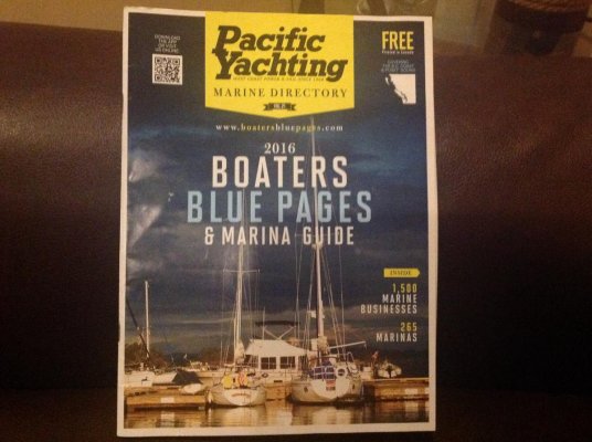
Last year we bought the Hamilton's book (Cruising the Secret Coast) and we have looked at many others that are all quite nice. I think you might find an updated Wagonners to be ideal - you can supplement with local things along the way. One worth picking up is the Pacific Yachting Marine Directory, Boater's Blue Pages and Marine Guide, which is free. It looks like a magazine. Their website is www.boatersbluepages.com.

Best Wishes,

Jeff

image.jpg
 
Last edited:
We use the Waggoner Cruising guide and our imagination - the charts are generally excellent so you don't always have to follow the herd.
 
We also recommend the Wagonners, our go to for just about everything.
 
Hemingway Douglass is by far the best guide.

Waggoner is much too marina oriented.
 
As others have posted Douglass and Waggoner are great. Depends a bit on what sort of trip you are looking for. Hamilton's is more off the beaten track. Great but you could spend many seasons cruising the area before feeling the need to try some of those destinations. There is a lot here! Dreamspeaker guides with their hand-drawn charts and presentation style seem less serious but cover the basics up to Desolation. I would not bother with their Broughton one - a bit simplistic.

I highly recommend the cruising planners. A great way to visualise and plan the options. They are often sold out when trying to buy them once you are in destination. Many people laminate them.

Here is the Desolation one. There are other too.
Desolation Sound & Johnstone Strait Cruising Planner Map - Waggoner Cruising Guide
 
Last edited:
San Juan Islands a Boaters Guidebook is very good. Quite informative and filled with charts, island maps, GPS coordinates and even a bit of a history lesson of the islands.

Blue Latitude Press - Cruising Guides and More!

We met the authors last year at Vendovi Island, great people.
 
While not a cruising guide, I wrote a blog about our trip up to PI in our Albin 25 that you might find useful. Princess Louisa Inlet 2010

We have a GB 36 now and cruise the area often.

BC is a wonderful place to cruise. You will enjoy it.
 
The Douglass books are much more detailed than the Waggoner and are very useful for planning anchorages and transiting fast current areas. The Waggoner is more general in nature but is still useful for the phone numbers and marina info. We use both.
 
The Douglass books are much more detailed than the Waggoner and are very useful for planning anchorages and transiting fast current areas. The Waggoner is more general in nature but is still useful for the phone numbers and marina info. We use both.

Your "we use both" comment is instructive. We have on board the Waggoner Guide, some Douglass books, some Dreamspeaker books, Northwest Boat Travel and the Burgee.

We use all of them. Some more frequently than others, but it's always nice to cross-reference or find that one guide has information that another does not.

I agree with Darren. I have used the Waggoner guides for years and it is the first thing I reach for, but we use others as well. Not only do each have their own emphasis, but it is nice to get several viewpoints.
 
I agree with Darren. I have used the Waggoner guides for years and it is the first thing I reach for, but we use others as well. Not only do each have their own emphasis, but it is nice to get several viewpoints.

I agree as well and this applies elsewhere too. We use everything we can get our hands on. Whether it's Alaska or the PNW or the Loop, trying to select where you'll go and what you'll do is fun, but a challenge. We start with a list of possibilities and then use many resources to narrow it down. They will present very different information and views.

We do the same cruising the east coast. We just made a quick trip up the coast and back. We looked at our charts, but also at any recent alerts and information on Active Captain, Waterway Guide or Cruisers Net. Especially since Matthew, you want the latest available information.
 
Back
Top Bottom